Introduction
Ayscoughfee Hall Museum stands in Ayscoughfee Gardens, five acres of public park. It is known that the present footprint and acreage of the Gardens dates back to at least 1732 when they can be compared to John Grundy's map of Spalding from that date. Maurice Johnson II (barrister and founder of the Spalding Gentleman's Society, 1688 - 1755) was probably responsible for laying the Gardens out. They were influenced by the fashions of the time and Johnson's strong connections with London.
Terrain
The triangular site sits on level ground.The following is from the Register of Parks and Gardens of Special Historic Interest. For the most up-to-date Register entry, please visit The National Heritage List for England (NHLE):
Formal gardens of the early 18th, 19th, and 20th centuries, now a public park, forming the setting to Ayscoughfee Hall, a museum.
Location, Area, Boundaries, Landform and Setting
Ayscoughfee Hall occupies an urban setting in the centre of the town of Spalding, on the east bank of the River Welland. The c 0.3ha triangular site sits on level ground, bounded to the west by Churchgate and to the east by Love Lane. The north-east boundary overlooks the church of St Mary and St Nicholas while the north-west boundary overlooks the Town Hall.
Entrances and Approaches
The present main entrance is from the west off Churchgate into the tarmac forecourt below the west front of the Hall. A magnolia planted in the 1950s lies in the centre of the forecourt with the pedestrian access into the gardens from the south-west corner through a brick garden wall. On the north side of the forecourt is a second entrance which leads east along an avenue of chestnuts to the east front of the Hall. This avenue was planted on either side of the carriage drive in 1819 (Pursglove 1996) although the original trees were felled in 1957 and subsequently replanted. There are several further pedestrian entrances around the perimeter of the gardens, that to the east marked by an iron gate flanked by brick gate piers set in the east wall.
Principal Building
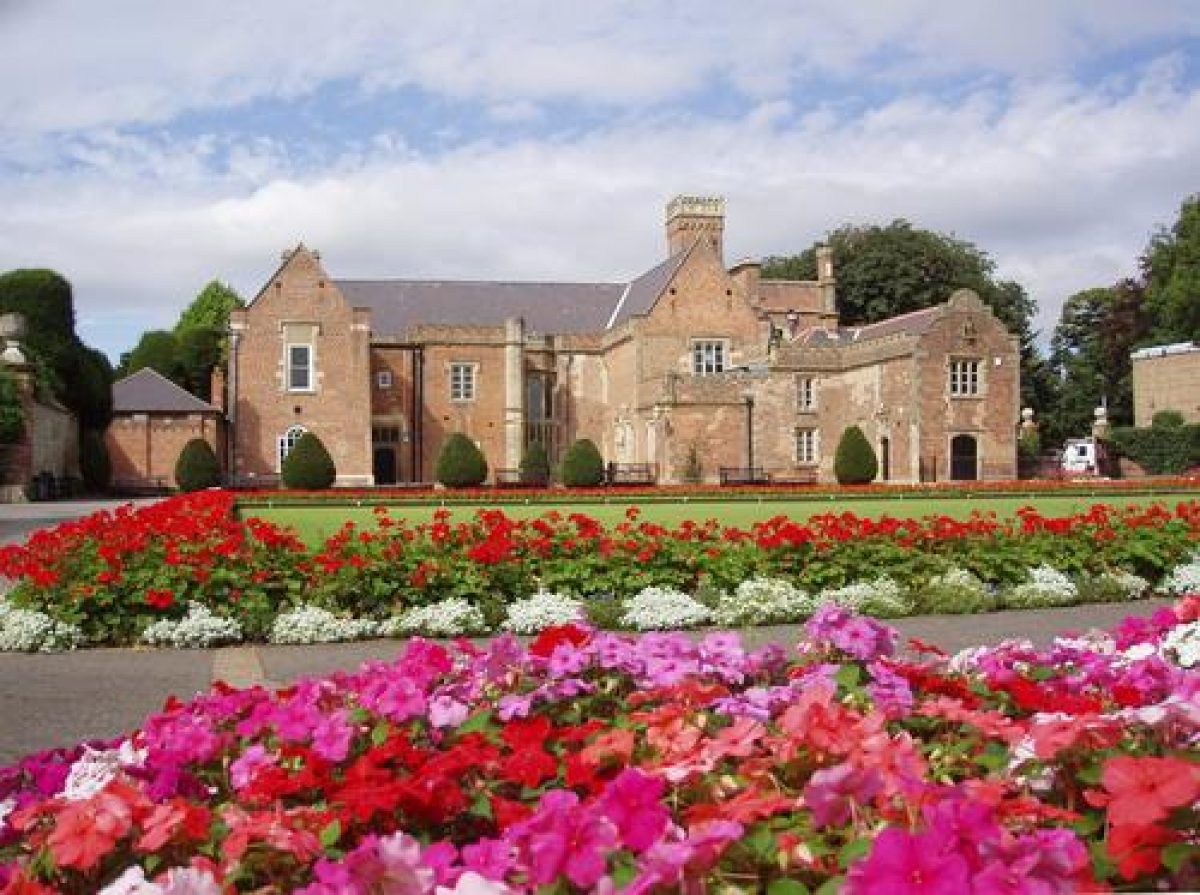
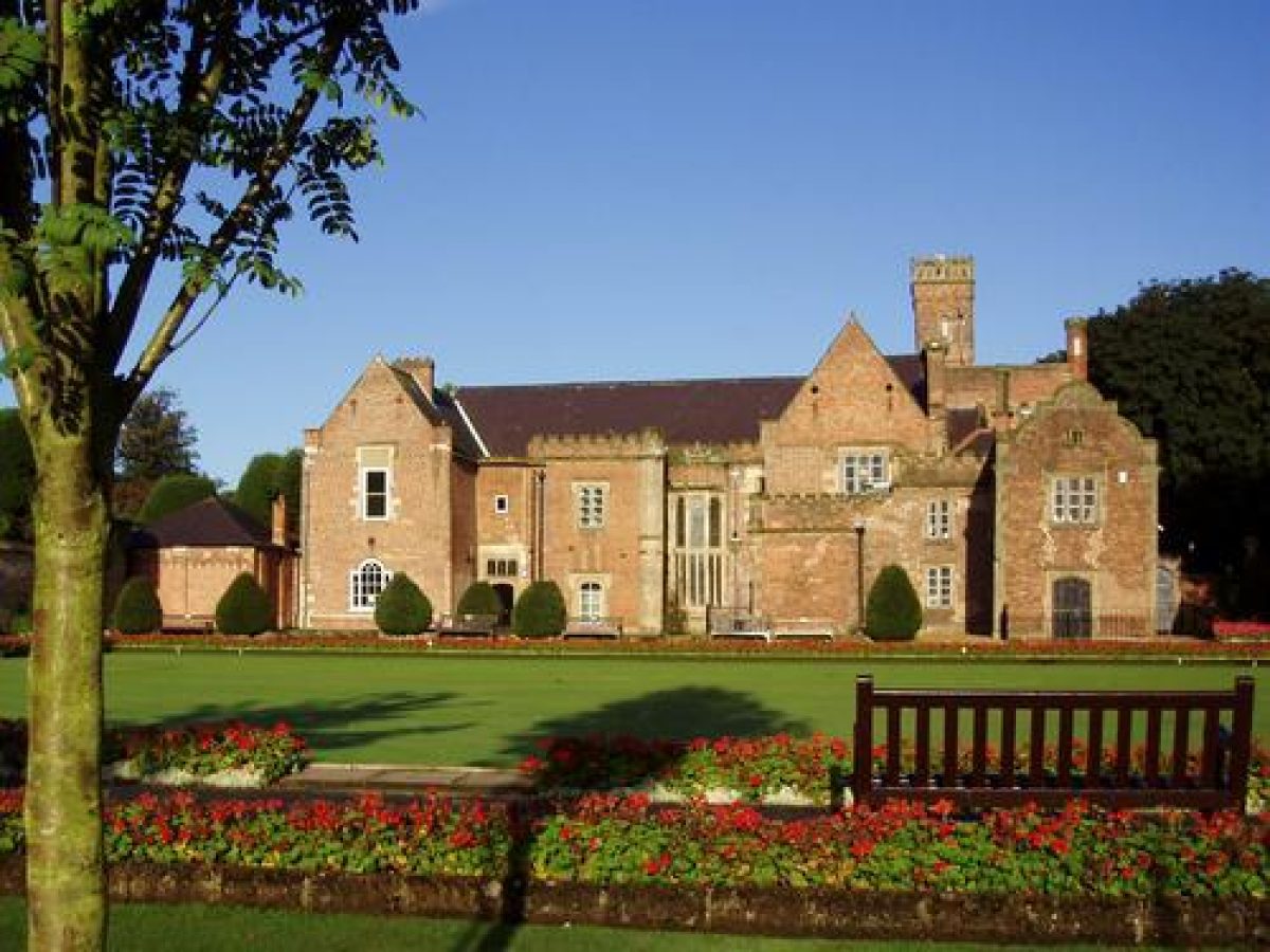
Ayscoughfee Hall (listed grade II*) is a small mansion standing in the north of the site. It is built of brick with stone bays and an arcaded porch on the west front, crenellations, and shaped gables. Richard Aldwyn erected a thatched property in the 1420s, but that was altered in 1772 for Colonel Maurice Johnston when the thatch was replaced; in 1794 for Rev Johnston when gothic windows were added; and in 1845 when it was given a Tudor character by William Todd.
The stable block was formerly located just beyond the east front but was badly damaged in a fire in the 1960s and was subsequently demolished.
Gardens and Pleasure Grounds
The gardens lie south and east of the Hall and are bounded to the west along Churchgate and partly to the east along Love Lane by a brick garden wall (partly early C18, listed grade II). Lying below the south front are the south gardens and the south lawn, separated from the Hall by a tarmac path. The lawn is flanked by yew hedges to east and west and from its south boundary a yew avenue extends towards the south end of the gardens. Midway along the axis of the avenue is a sundial on a fluted plinth set in a circular brick surround. On the west side of the avenue is an area known as the Formal Garden, laid out with a lawn inset with flower beds around a stone obelisk overlooked by a pergola under brick pillars, located c 400m to the south-south-west of the Hall. To the east of the avenue is an area of small, irregularly shaped lawns planted with clipped yews, at the southern end of which, c 400m south of the Hall, stands an icehouse surrounded by shrub planting within C20 railings. A serpentine path runs around both garden areas.
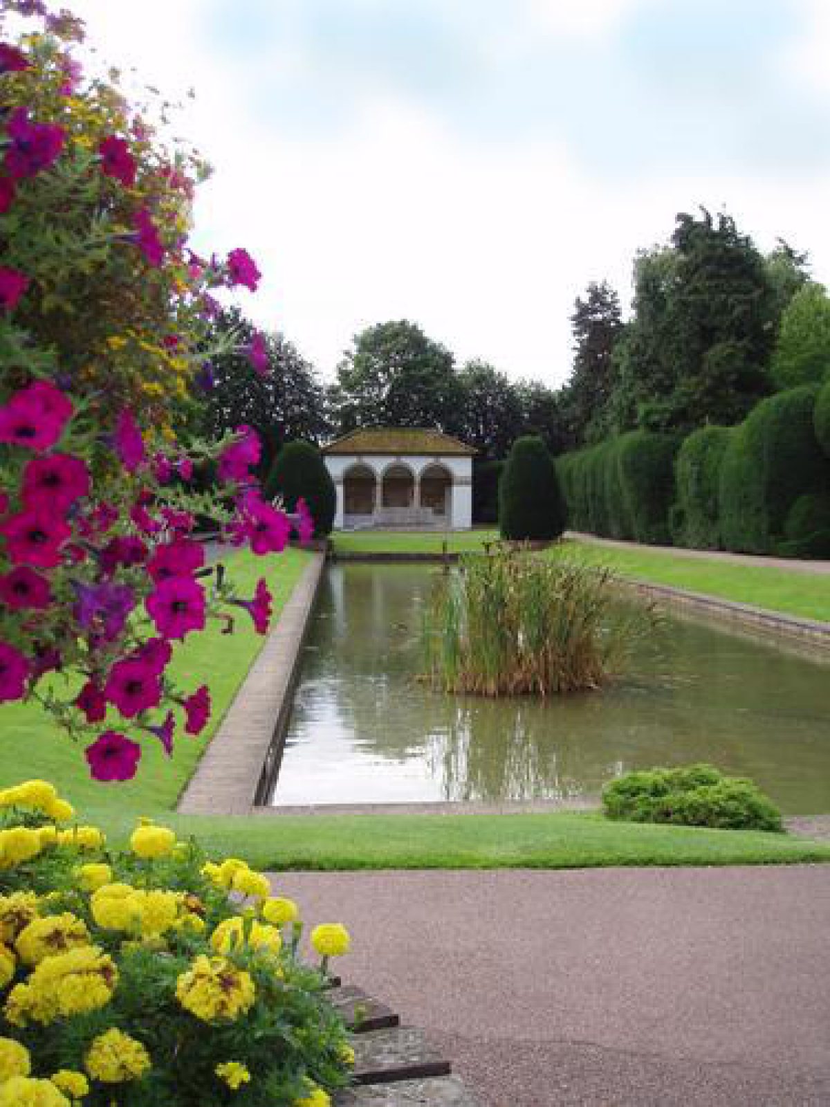
To the east of the south lawn is a stone-edged formal canal with two fountains, surrounded by sloping lawns and paved paths, occupying the same position as a canal shown on the 1732 Grundy map. Standing at the southern end of the canal, which was reworked in the 1920s, is a war memorial (1922, listed grade I) designed by Sir Edwin Lutyens as a classical loggia with a Tuscan Doric arcade and pantile roof. The east side of the canal is bordered by a yew hedge broken at intervals by late C20 ironwork arches which lead to the Peace Garden, laid to lawns cut with informal flowers beds around a stone obelisk. This garden was created in 1994 and occupies the site of a bowling green laid out by the District Council in 1908. Beyond the Peace Garden, on the eastern boundary of the site is a children's play area, a small yew-enclosed pond garden, and an aviary which was created in 1925 on the site of an old tennis court.
Lying below the east front of the Hall is a brick-paved herb garden with iron railings dividing it from a shrub and flower bed beside a path overlooking a second bowling green, beyond the northern boundary of which is a long narrow Scent Garden with a late C20 glasshouse at its eastern end. The brick and tile bowling pavilion and café stand on the site of the stables, on the northern edge of the bowling green, to the east of which is an L-shaped putting green partly surrounding tennis courts, added to the gardens in 1925 and located in the north-east corner of the site. Between the tennis courts and the aviary to the south is a path and rockery with a central cascade flowing into a long narrow pool running parallel with the path.
The gardens were originally laid out by Maurice Johnston before 1730 and contained paths, groves, flower beds, and grass plats, as well as a long canal, all enclosed by walls as depicted on the Grundy map of 1732. Within the later development of the gardens as a public park, parts of the structure of Johnston's layout survive.
Maps
- J Grundy, A plan of the town of Spalding ..., 1732 (Lincolnshire Archives)
- Capt A Armstrong, Map of the County of Lincolnshire, 1779 (Lincolnshire Archives)
- OS 6" to 1 mile: 2nd edition published 1906
Archival items
- Indentures between owners and trustees of Ayscoughfee Hall, May 1898; supplementary indenture between trustees and Spalding Urban District Council, August 1902 (Lincolnshire Archives)
Description written: June 2000 Redrafted: May 2001 (EMP)
Register Inspector: CEB
Edited: May 2002
Minor Amendment: 18 November 2015
- Visitor Access, Directions & Contacts
Telephone
01775 764555Access contact details
Ayscoughfee Gardens are open from 8am, until 30 minutes before dusk.
Entrance to the Gardens is free to all visitors.
Ayscoughfee Hall Museum is open on Tuesdays, Saturdays and Sundays, 10am - 2pm.
Directions
Entry to the Gardens is via Chestnut Avenue (next to the Vista car park).
- History
The following is from the Register of Parks and Gardens of Special Historic Interest. For the most up-to-date Register entry, please visit The National Heritage List for England (NHLE):
15th Century
Richard Aldwyn built Ayscoughfee Hall in the 1420s, possibly including parts of an earlier building (Glenn and Taylor 1999).
17th - 18th Century
The property passed through several hands before John Johnston bought the Hall in the mid-17th century and it was his granddaughter and her husband, Maurice Johnston, who were responsible for laying out gardens in the 1730s. The design is attributed to William Sands (Pevsner et al 1989) and appears on the John Grundy map of 1732. Maurice's son, also Maurice (1688-1755), inherited Ayscoughfee Hall in 1747 and his son, Colonel Maurice Johnston, to whom it passed in 1775, made various alterations to the Hall in 1772. When Colonel Johnson died his son, the Rev Maurice Johnston, incumbent of Spalding parish church, inherited the property and made significant alterations to the Hall and the grounds in 1794.
19th Century
The Rev Maurice's grandson, also Maurice, succeeded to the estate in 1834 and commissioned William Todd to further alter the Hall before moving away in 1851 and letting the property. Maurice's widow, Isabella Mary Johnson sold the Hall and grounds to a committee of Spalding citizens in 1898 and they were presented to Spalding Urban Council in 1902 to celebrate the coronation of Edward VII.
20th Century
The grounds were opened as a public park, while from 1915 to 1920 the War Office took over the Hall; after that part of it was used by Ayscoughfee School between 1920 and 1982, and part used as a free public library. In 1974 ownership passed to South Holland District Council and in 1987 the Hall opened as a museum. The grounds remain (2023) in public ownership.
- Associated People
- Features & Designations
Designations
The National Heritage List for England: Register of Parks and Gardens
- Reference: GD1967
- Grade: II
Features
- Ornamental Lake
- Hedge
- Description: Clipped yew hedges.
- War Memorial
- Description: The War memorial designed by Sir Edwin Lutyens is at the end of the ornamental lake.
- Icehouse
- Hall (featured building)
- Now Museum
- Description: The hall was built in the 1420s. It has been modeified several times since, and is now a museum.
- Earliest Date:
- Key Information
Type
Park
Purpose
Ornamental
Principal Building
Education
Survival
Extant
Hectares
3
Open to the public
Yes
Electoral Ward
Spalding Castle
- References
References
- {English Heritage Register of Parks and Gardens of Special Historic Interest}, (Swindon: English Heritage, 2008) [on CD-ROM] Historic England Register of Parks and Gardens of Special Historic Interest
- Pevsner, N. and J. Harris, {The Buildings of England: Lincolnshire} (London: Penguin, 2nd edition 1989), pp. 675-7 The Buildings of England: Lincolnshire
- Anderson & Glenn {Conservation Plan, Historical Appraisal of the Grounds} (2000) Conservation Plan, Historical Appraisal of the Grounds
- NPS Group and NAU Archaeology {An Archaeological Desk Based Survey of Ayscoughfee Hall Gardens. 2000, Conservation Plan, Historical Appraisal of the Grounds} (2008) An Archaeological Desk Based Survey of Ayscoughfee Hall Gardens. 2000, Conservation Plan, Historical Appraisal of the Grounds
- White, W., (1856), p 845 Directory of Lincolnshire
- 19 (10 June 1906), pp 730-5 Country Life
- Rawnsley, W F., (1926), pp 445-6 Highways and Byways in Lincolnshire
- Thorold, H, and Yates, J., (1965), p 124 Lincolnshire, A Shell Guide
- Pursglove, R., (South Holland Museums Service, 1996) The History of Ayscoughfee Hall