
Introduction
Appuldurcombe has the remnants of an 18th-century landscape park. At its most extensive the park covered around 100 hectares, but is now in divided use and ownership. Features include an icehouse, four gate lodges and a ruined obelisk.
Terrain
The parkland at Appuldurcombe rises up from east-north-east to west-south-west.
The following is from the Register of Parks and Gardens of Special Historic Interest. For the most up-to-date Register entry, please visit The National Heritage List for England (NHLE).
A late C18 landscape park laid out to a design by Lancelot Brown around a C17 and C18 house which was altered in the early-mid C19 by the addition of ornamental pleasure grounds forming an inner park around the house.
Location, Area, Boundaries, Landform and Setting
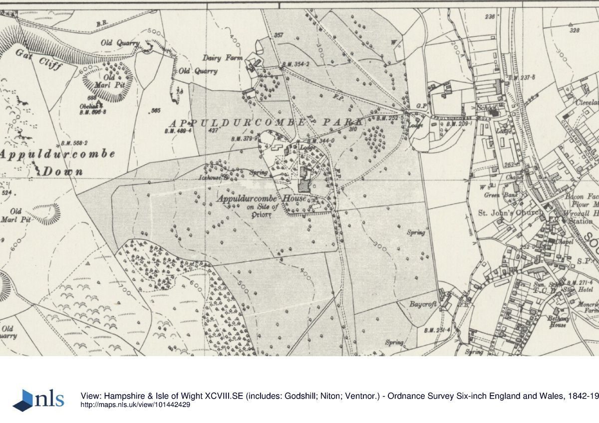
Appuldurcombe lies to the immediate west of Wroxall village and the B3327 road running south to Ventnor. The c 156ha site, comprises 6ha of ornamental pleasure and kitchen grounds and 150ha of parkland, woodland and downland.
The site is enclosed on the north-east and northern boundaries, and on sections of the west and south boundaries, by a stone rubble wall (all lengths listed Grade II), parts dating from the early C18 and parts erected as part of Brown's design of 1779. The remaining boundaries are fenced, with hedges to the south and south-east. The southern half of the eastern boundary, east of Brown's reverse ha-ha, is bounded by a stream. The landscape is open, grazed or farmed downland. The detached kitchen garden (c 60m east of the park) is bounded to the south by Appuldurcombe Road and housing to the south and east (Wroxall village) and by open fields to the north.
Appuldurcombe was designed with the surrounding landscape which emphasised the grandeur of the house and the visual relationship between the house and the land that immediately surrounds it makes up much of its charm. Its siting within a bowl formed by the downs, enhanced by the attractive and dramatic landforms, fine views and contrasting patterns of land use and vegetation largely determined by the site's geology, all contribute to a magnificent setting. Appuldurcombe Down and Gat Cliff are major landmarks over a wide area. The Down forms part of a continuous ridge of chalk downland running south to the coast from which there are panoramic views of the island and the sea from the ridge top.
Entrances and Approaches
Appuldurcombe House (listed Grade I and a scheduled monument) was particularly well sited. Lying within a fold in the downland landform it could be approached from the north and south, and even to some extent the east, and not be visible until the observer was quite near.
Originally the entrance to the park was from Godshill via the Freemantle Gate, a late C18, stone ashlar round-headed carriage arch generally attributed to James Wyatt (listed Grade II* and a scheduled monument) repaired in the late C20 and again in the early C21. The approach through Godshill was probably already in place before Richard Worsley began his improvements but the impact of what Richard called the ‘triumphal arch' is dramatic as the Gate appears suddenly at very close range, emphasised by the long approach through a narrow valley across Worsley land from Godshill. Freemantle Lodge (listed Grade II) was later built beside the Gate in the early C19 and has recently been converted to holiday accommodation.
From Freemantle Gate the whole bowl of the park opens out but the house is hidden. Brown designed a serpentine drive that ran south-eastwards from the gate through clumps of trees planted to hide the house from view, before turning in a great westward sweep to approach the east front of the house. There are a few surviving sections of the serpentine drive but the current drive, now metalled, follows a different course from Freemantle Gate to the house from that shown on Brown's plan.
The serpentine drive was a prominent feature on Brown's plan of 1779 and was one of the central features of his design, winding through woodland and contrasting open areas to the crest of Appuldurcombe Down and carefully laid out to give the greatest variety of scenery and viewpoints as well as emphasising the extent of the Worsley estates. The serpentine drive left the house and wound its way into Appuldurcombe Wood, and as it sprang from the dense wood, the whole of the valley and the island was displayed from the summit of Appuldurcombe Down. There are a few surviving sections of the drive in the south part of the park and in Appuldurcombe Wood. To the south of the house, the drive continued to the exit on the park's southern boundary (the course still survives) where later, in 1805, a lodge was built at the exit known as Span Lodge.
Another drive shown on the Brown plan, now the main entrance to the park, lay roughly in the centre of the park's east boundary. In the Regency period this approach is likely to have become the principal entrance. The gateway flanked by stone rubble piers is of similar style to the gateways to the Inner Park and probably dates from the C19 as does Old Church Cottage built as its lodge. Old Church Cottage is a Regency Gothic building and stands within its garden on the south side outside the entrance. The drive is lined on the north side within the park with mature trees, many have Tree Preservation Orders (TPOs).
The drive, now metalled, continues west from the east entrance across the park, where the car park is sited, to arrive alongside a gateway, flanked by dressed-stone piers, in the northern, stone-walled boundary of the Inner Park pleasure grounds which surround the house. Immediately inside the wall, on its western side, the drive passes a single-storey, ashlar lodge (listed Grade II) built in the early to mid-C19 by the Earl of Yarborough. The drive continues on a straight course southwards to arrive alongside the west front of the house. Through a second gateway in the north wall of the Inner Park, some 25m west of that by the lodge is the entrance to the two-storey, coursed-stone, early to mid-C19 stables (listed Grade II) and brewhouse (c 100m north-west of the house) converted in the 1990s to holiday and visitor accommodation.
Principal Building
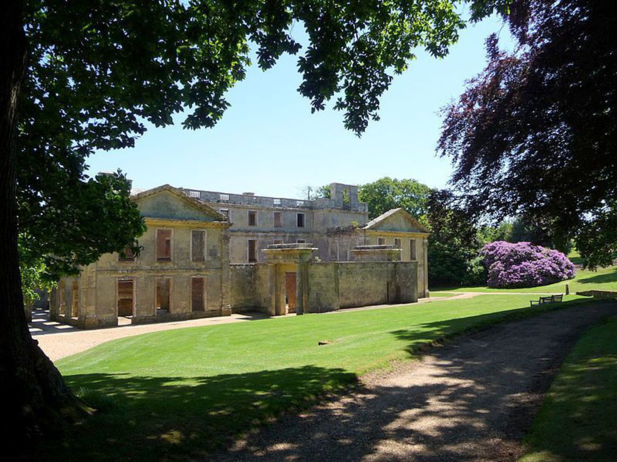
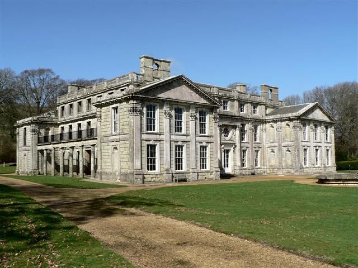
Appuldurcombe House (listed Grade I and a scheduled monument) stands roughly in the centre of its park, within the Inner Park. The mansion, which is one of the most significant houses of the English Baroque style, survives as a roofed shell. It consists of a central, three-storey, square block with a projecting pavilion at each of the corners. Built in Isle of Wight greensand ashlar with Portland stone dressings and partially covered with a slate roof, it was begun in 1701 for Sir Robert Worsley to designs most probably by the architect John James and replaced the former Tudor manor house although with some incorporation of the earlier fabric.
The present, principal, east range, fronted by giant Corinthian pilasters between the windows and terminated by pavilions, was the only part completed by 1711 by Robert. The present east front, south-east pavilion, south and east sides of the north-east pavilion, the south and east sides of the south-west pavilion and the south front are known to comprise the original baroque house. Probably construction of the north wing, and possibly the north-west part of the south-west pavilion and the whole of the north-east pavilion, along with a complete refurbishment of the interiors, was carried out between 1773 and 1782, supervised by Brown's associate William Donn for Sir Richard Worsley. The porte cochere on the west front and the colonnade linking the pavilions on the south front were added between 1805 and 1885. The present, partial re-roofing with slate and the insertion of sashes to the east front of the central block and the east pavilions was undertaken by English Heritage from 1981.
Gardens and Pleasure Grounds
The Inner Park or pleasure grounds (scheduled monument) surround the house on all sides, enclosing it from the Outer Park. A c 1.8m high stone wall forms the north-west and north-east boundaries, the latter section containing a pedestrian gateway known as the Hampton Court Gate with Ionic pilasters and half columns (walls and gateway listed Grade II). The eastern and southern boundaries are enclosed by c 1m high iron railings, the southern stretch set on top of a stone-walled ha-ha which extends (without railings) halfway along the western boundary (the ha-ha is part of the scheduled monument).
As well as Appuldurcombe House, the Inner Park contains the ashlar lodge (listed Grade II), stables (listed Grade II) and former brewhouse as well as a shop and café. Behind them is a conspicuous group of mature beech (Fagus sylvatica) and sweet chestnut (Castanea sativa).
The grounds are lightly wooded with trees of mixed ages and species and a grassed floor and are underplanted in places with informal, island shrubberies, not greatly altered from their Regency character shown on engravings by George Brannon and others in the early to mid-C19. The enclosure and planting of the Inner Park were almost certainly complete by the end of the 1820s; a contemporary description confirms their design to have been the work of the Earl of Yarborough's father.
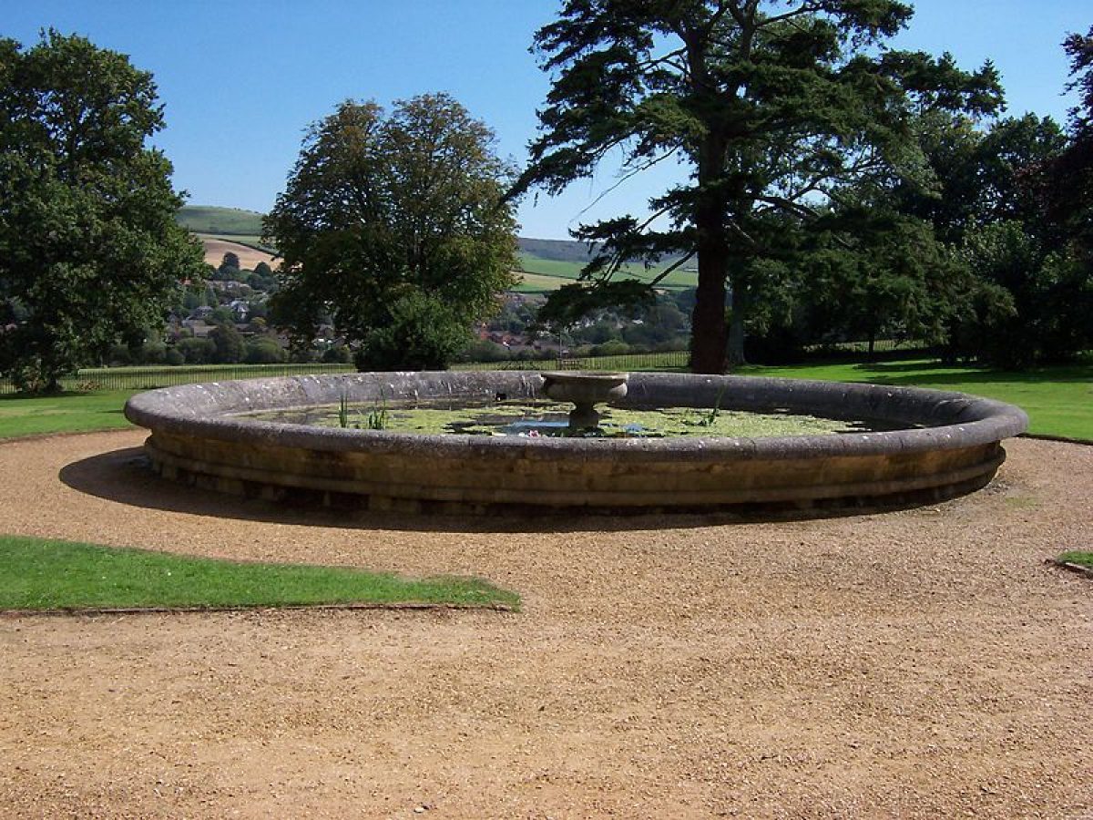
The east front of the house overlooks a broad, gravelled walk and a fairly open lawn framed by trees. A stone fountain basin, also part of the early C19 improvements, stands some 15m from the east front, on its central axis. In front of this ‘Irregular-shaped little parterres' mentioned in 1834 have since gone. Further serpentine walks criss-cross the garden, the more major ones linking the house with the Outer Park via further gateways, in the south-east corner, in the middle of the western boundary and beside the lodge. It is possible that two cedars of Lebanon (Cedrus libani), the Douglas fir (Pseudotsuga menzesii) and some of the beech (Fagus sylvatica) and possibly the Rhododendron ponticum planted here may also date from the early C19.
Park
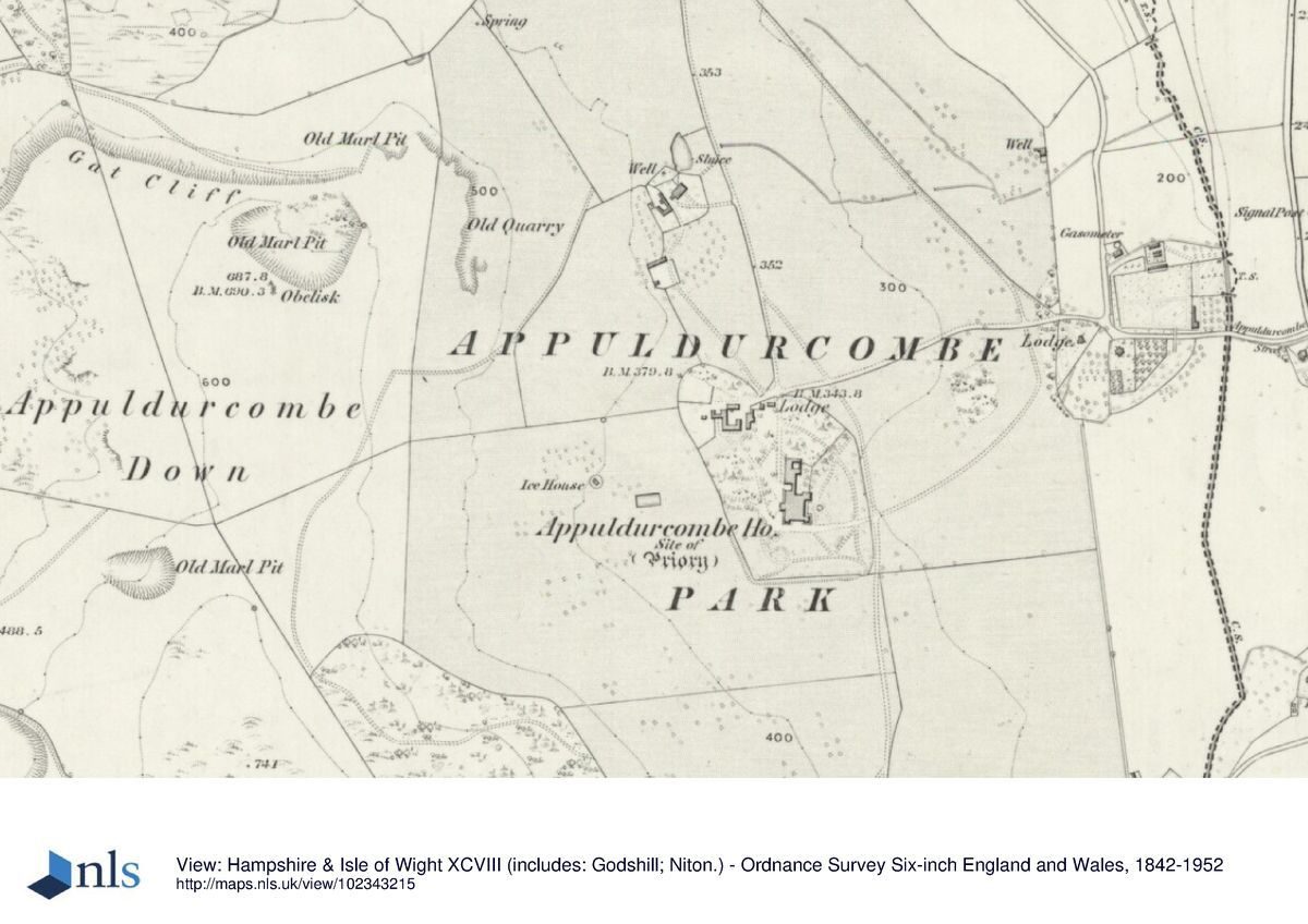
Although the land was almost certainly farmed from the period of the founding of the abbey, there is no documentary evidence for the existence of a medieval deer park. There are references to Appuldurcombe Lodge, a deer lodge, from 1557 onwards and references to a deer keeper in the late C17 which implies the existence of a park. There are references to ‘a new park' and ‘new lodge' by 1708 and its boundaries were first recorded on Andrew's maps of 1769 and 1775. Appuldurcombe Lodge is shown as a deer lodge on Brown's plan of 1779.
The park was enlarged as part of Brown's commission in 1779. The park is enclosed to the north, east and west by a stone wall of Isle of Wight stone of varying height (up to 1.9m in the northern length) and in various states of survival and repair (listed Grade II). The position of the wall was part of Brown's design; the locations he chose for the new wall opened out the park and related it far better to its surroundings. His design shows the proposed extensions to the park boundaries to the east, west and south: to the west, placing the wall at the foot rather than the crest of Appuldurcombe Down enabled unobstructed views to and from the ridge, and to the east he opened out the landscape by the construction of a reverse ha-ha, and to the south he created a soft edge in which the park faded into the landscape to the south.
Important vistas within the landscape were designed to accentuate existing landforms; Cook's Castle folly (still extant in 1839 but substantially damaged in 1940 by a spitfire crashing. The position is approximately marked as by a stone cairn engraved ‘Site of Cooks Castle') was sited on the promontory of St Martin's Down and the obelisk stands on the summit of Appuldurcombe Down. The truncated obelisk of Cornish granite (listed Grade II), was built as an eyecatcher (it could be seen from Cook's Castle) in 1774 by Richard Worsley to commemorate his great-uncle, Robert. Following lightning damage in 1831, only the plinth and a short section (rebuilt from scattered stone in 1984) now survive from its former c 21m height.
Appuldurcombe Wood, an area of mixed woodland on the downland slopes in the south-west corner, is also a point of interest designed to heighten the impact to hide the approaching views as the Down is climbed. The site is ancient woodland and had an important role in the C18 designed landscape as part of the sequence of features along the Down. There is some survival of Brown-period planting in Appuldurcombe Wood, as the wood is dominated by mature beech (Fagus sylvatica) and sweet chestnut (Castanea sativa).
Apart from Appuldurcombe Wood, the park is open in character, the whole under permanent pasture. There are a few dividing hedges (others having been removed in the early C21 under Countryside Stewardship) with an occasional hedgerow tree. The few remnant clumps and individual trees dotted about include the only survivors from Brown's design which escaped the disparking and tree clearance following the sale after Pelham's death in 1846. Scrub is invading areas of the pasture on the slopes of the downland in the northern part of the park where there is extensive earthwork evidence of former quarrying which occurred from the medieval period until probably the C18.
Notable designed views still survive. From the Freemantle Gate there is a fine view eastwards to the sea framed by woodland on St Martin's Down ridge which once would have had Cook's Castle as a focal point. Freemantle Gate is prominent when viewed from the site of Cook's Castle and the approach to it, forming a landscape composition along the downland ridge to Appuldurcombe Wood with the obelisk. The fine grouping that Freemantle Gate forms with the obelisk and Appuldurcombe Wood in the panorama from the Castle may have been conceived as an entity.
From Appuldurcombe Down there are views across the whole island, while from the Marl Pit, a large steep-sided quarry pit, there are long views northwards. In the south, moving the boundary to lower ground allowed the parkland to fade into the countryside beyond. In contrast to these long views, the views from the house are more restricted and today are principally of the south edge of Wroxall, with the downs beyond, although views from the upper floors would have been more commanding. The main view east looks across the park to Wroxall and beyond to St Martin's Down on which stood Cook's Castle.
Typical features of a Brown design include the selective retention of older trees and the siting of clumps to structure views and vistas. The new plantations that appear to have been directly instigated by Brown were small but significantly sited but few survive. The Long Plantation softened the approach to Freemantle Gate and others framed a view eastwards to Cook's Castle and probably framed a view from the house to the seasonal lake, but few of these survive; some of the trees in these areas are designated with TPOs. Planting at the Marl Pit may have helped to frame the viewpoint and this woodland still survives.
Possible evidence of Brown's suggested earthmoving can still be seen. Near Freemantle Gate the foreground of the view towards Cook's Castle appears to have been scooped out to flowing contours. In front of the house there is similar work making a gentle fall to the reverse ha-ha and exaggerating the higher ground around the approach drive. The Marl Pit quarry has been partially landscaped to form a viewpoint.
East of Appuldurcombe House is Brown's reverse ha-ha comprising a stone wall on the eastern side of its now-remnant, stone-lined ditch. This may have been fed by the spring noted on later maps and would have served as a drain that could be used to create a narrow seasonal lake out of a stream, a tributary of the Yar, by flooding the surrounding meadowland. It would have been visible from at least the upper storey of the house but only part of this meadow up to the stream survives; the rest has been developed. The Brown plan also included Cleveland Wood, which has now been totally lost to development. The Regency period park lodge though, Cleveland Lodge (listed Grade II) survives to the east.
Other buildings are present in the park. Some 220m due west of the house and Inner Park, a late C18 icehouse with a stone revetment wall and stone-vaulted entrance below a scrub and grass covered mound (listed Grade II) stands in an open field. The late C18 stone and slate-roofed farmhouse and C20 agricultural barns of Appuldurcombe Farm lie some 250m north of Appuldurcombe House, the farmhouse built on the site of the deer lodge. The farmhouse has a datestone of 1780 but its picturesque appearance suggests that it may have been remodelled in the early C19 by Pelham. Stenbury Down Radio Station is sited in the western part of the park.
Kitchen Garden
The kitchen garden stands outside the eastern park boundary, some 60m from the present entrance to the park, on the north side of Appuldurcombe Road. It is trapezoid in plan and is enclosed on three sides by 3m high walls of stone rubble to the outside face and rendered brick to the inside, with ashlar piers and on the fourth by a brick wall; all walls being capped by a pitched, tiled coping. The garden was constructed as part of Brown's improvements in 1779 and typical of his work in the placing of the walled garden out of view of the house yet easily accessible and on the route of one or more drives. By 1862, the garden had been reduced at the east end.
The walled garden is now (2015) used as the Appuldurcombe Holiday Centre, a caravan park.
Reasons for Designation
Appuldurcombe, Wroxall, Isle of Wight, is registered at Grade II for the following principal reasons:
- Historic interest: as a late C18 landscape park, a landscape type which is considered among the country's most important contributions to European civilization;
- Designer of national importance: laid out to a design by Lancelot ‘Capability' Brown (1716-83), the pre-eminent English landscape designer of the mid to late C18;
- Design influence of the natural landscape: designed within a bowl formed by the downs, emphasising the grandeur of the house, and enhanced by the attractive and dramatic landforms and panoramic views of the island and the sea;
- Group value with other heritage assets: with Appuldurcombe House (listed Grade I and a scheduled monument), one of the most significant houses of the English Baroque style; and wider estate ensemble including Freemantle Gate (listed Grade II* and a scheduled monument), Hampton Court Gate (listed Grade II); obelisk, lodges and boundary wall listed Grade II; * Documentation: including Brown's design of 1779, contemporary account books and engravings.
Maps
- OS Surveyor's Notebook (1794)
- Plan of the Manor of Appuldurcombe 1800 (IWRO JER/WA/33/45)
- William Watts, Appuldurcombe Estate Map (1773) IWRO
- Visitor Access, Directions & Contacts
Website
http://www.appuldurcombe.co.uk/Access contact details
Opening times: The site is open daily from April to October. Hours are from 10am to 4pm, closing at 12 noon on Saturdays. Currently interior space in the house remain closed.
Dogs on leads are welcome and there is a car park 150 metres from the house.
For more detailed visitor information visit the English Heritage website.
Directions
The park is off the B3327, west of Wroxall.
- History
The following is from the Register of Parks and Gardens of Special Historic Interest. For the most up-to-date Register entry, please visit The National Heritage List for England (NHLE):
11th - 15th Century
Appuldurcombe was possibly part of the manor of Wroxall which, in 1086, was owned by William the Conqueror. Shortly after 1100, it became a dependent priory of the Norman Abbey of Montebourg until it was sold to the Poor Clares of Aldgate in 1461, the nuns soon after leasing it to Sir John Leigh.
16th Century
It was through his daughter's marriage in the early C16 to Sir James Worsley (d 1538) that the Appuldurcombe estate came into the possession of the Worsley family and it was to remain the Worsleys' seat on the Isle of Wight for the next 300 years. James Worsley was a favourite of the Crown, being knighted by Henry VIII and, in 1511, granted a monopoly of the major official posts on the island including its military captaincy. Appuldurcombe was granted to James Worsley in 1527. The estate passed down through the Worsley family, the sons making a series of marriages with important mainland families which extended their estates.
17th Century
The C16 house is thought to be the one illustrated in Richard Worsley's ‘History of the Isle of Wight' of 1781 which is annotated by Robert Worsley ‘Appuldurcombe as I found it in 1690 all of which I have left not one stone standing'. A wall foundation was recorded by archaeologists under the present house during works in 1986 but it was not clear whether the foundation related to the abbey or to the C16 house. Both are now protected within the area of the scheduled monument.
In 1677 Sir Robert Worsley (1670-1747) inherited. Following his return from a grand tour in 1690, he began in 1701 to build Appuldurcombe House (listed Grade I and a scheduled monument) to designs most probably by the architect John James (c 1672-1746).
18th Century
Robert Worsley was a keen gardener although the garden was apparently ‘no bigger than your parlour' (Lady Worsley to her father, 1702). John Andrew's map of 1769 shows that the house lay within a walled enclosure and walled gardens with ‘melon glasses' and greenhouses were laid out as mentioned in the account books of 1711 and 1716.
Parch marks on air photographs of 1946 show what might be three walled gardens on the south-facing shallow slope to the north-west of the house. The so-called Hampton Court Gate (now ex situ) appears to be the only surviving structural evidence of the gardens. It is of early C18 date and is thought to have originated from the grounds and possibly moved to its present location (set into the wall of the Inner Park) in the Regency period. William Watts' estate plan of 1773 and William Cooke's 1808 engraving show the house devoid of gardens and set in well-planted parkland against a western backdrop of trees.
Robert Worsley was succeeded by his cousin Sir James Worsley of Pylewell in Hampshire. No further work was done to the house, though, until the succession of James Worsley's grandson, Sir Richard Worsley (1751-1805), in 1768. Richard Worsley returned from his grand tour in 1772 and at once set about completing Appuldurcombe and improving its landscape, probably with architectural advice from James Wyatt (1746-1813). The removal of a walled enclosure from around the house (as shown on Andrew's map of 1769 but absent on his later one of 1775) was likely to have been undertaken by Richard.
Appuldurcombe provided a large canvas on which Richard could execute his landscape designs. The house lay on gently sloping land enfolded by the steep slopes and high ground of the South Wight Downland to the west. Appuldurcombe Down has magnificent views across the whole of the island and beyond at one of its highest points. In his ‘History of the Isle of Wight' of 1781 Richard described the view ‘The different eminences command most extensive and grand prospects. On the east is seen St. Helen's road, Spithead, and Portsmouth; on the west, the Cliffs at Freshwater, the Dorsetshire coast, and the Isle of Portland; on the north is a view of the new Forest and the channel, by which the island is separated from the other part of the county; and on the south, is the British Channel'. It was an obvious place for Richard in 1774 to site an obelisk (listed Grade II) in memory of his great-uncle, Sir Robert Worsley.
The designed landscape stretched eastward beyond the confines of the park to take in St Martin's Down where a folly known as Cook's Castle was erected. Cook's Castle would have been widely visible from the north part of the park. It was built at some time in the mid 1770s, and although Richard described it as the site of an ancient ruin there is no evidence for this. It was described by John Hassell in his ‘Tour of the Isle of Wight' in 1780 and illustrated by George Brannon in 1839.
On 19 January 1778, Lancelot Brown Junior (1748-1802), the son of Lancelot 'Capability' Brown (1716-1783), wrote to Sir Joseph Banks enclosing a copy of the inscription on the obelisk at Appuldurcombe. In 1779 Richard commissioned Lancelot ‘Capability' Brown to prepare a scheme for further transforming the surroundings of the house. Brown's scheme extended the 1769 park boundaries, added new parkland plantations, designed views, a serpentine drive and planting which exploited the dramatic topography of the downland setting. He also designed a reverse ha-ha to keep deer in the park and to create a water feature; and a walled kitchen garden.
An entry in Richard Worsley's notebook for 1780 gives a long list of fruit trees that were most probably planted in the walled garden. Entitled ‘a list of fruit trees planted at Appuldurcombe Park 16 December 1780', 287 items are listed including a number of wall trees. Brown's proposals of 1779 are shown overlaid upon the 1773 Watts estate plan and are referred to in his account books as ‘Appuldurcombe: A journey there in 1779 and a Plan for the alteration of the place'. There is record of a payment of £52.10.00 to Brown (Masters 2005, 32, footnote 69). A surveyor's drawing of 1794 and an estate plan of c 1800 show that Brown's scheme was largely carried out; it was admired by William Gilpin on a visit in 1783. Brown's associate William Donn appears to have played a significant part in the works to the house; he was paid nearly £4,000 between 1774 and 1782.
19th Century
Following a disastrous divorce, Richard Worsley spent much time abroad although his expeditions brought back a significant collection of Greek marbles and pictures to Appuldurcombe. On his return he retired to Sea Cottage in St Lawrence, dying in 1805; the estate was inherited by his niece Henrietta who married Charles Anderson-Pelham, eldest son of the first Baron Yarborough of Brocklesbury Park and the effective founder of the Royal Yacht Squadron.
He was created Earl of Yarborough, the Baron Worsley of Appuldurcombe in 1837 and although Appuldurcombe perhaps became less of an interest to him after he inherited Brocklesbury, he made substantial changes to the park and house. He altered the exterior appearance of the house by adding the colonnade, balcony, porte cochere and service rooms. He also built the largely-surviving range of service buildings north of the house and a group of picturesque Regency-style buildings, but most have gone, adjacent to Appuldurcombe Farm. A contemporary description (Yarborough papers 11/2/2, Lincolnshire Archives) of the Inner Park confirms that its layout, completed to its present form during the 1820s, was, however, the work of Pelham's father, whose shrubberies and flower gardens at Brocklesbury were laid out by Humphry Repton. The Inner Park enclosure with its mixture of shrubberies, trees, a formal parterre and winding walks within a marginal fringe of light woodland (engraved by Brannon in 1825) show a Regency-style garden typical of its period.
Charles Pelham died in 1846 and his son began to sell the estate in 1851. Its eventual purchaser, Vaughn Wynne Williams, broke it up and by 1862, the substantial tree cover still present in 1855 had been greatly reduced and the park divided into large fields. The house was subsequently leased to a school until the 1890s when it became a temporary home for Benedictine monks from France.
20th Century
It was unoccupied from 1909 except for wartime use, the damage to the roof and windows by a landmine in 1943 hastening its decay. The Ministry of Public Buildings and Works took it into guardianship in 1952, the negotiation period for which saw some demolition and the removal of all its timber and lead and its plaster ceilings (these last are in storage at Fort Brockhurst, Gosport). The MPBW consolidated the surviving shell as a ruin. Subsequently the majority of the Appuldurcombe estate was purchased by the Owen family and in the 1990s the stable block and brew house were converted to holiday apartments and a shop and exhibition room serving a falconry centre.
21st Century
The estate remains in private ownership with the house and Inner Park in a guardianship agreement with the Secretary of State and looked after by the English Heritage Trust.
Period
18th Century (1701 to 1800)
- Associated People
- Features & Designations
Designations
The National Heritage List for England: Register of Parks and Gardens
- Reference: GD1923
- Grade: II
Features
- Gate Lodge
- Description: There are three lodges with approach drives and a fourth lodge to the north of the house.
- Tree Belt
- Ruin
- Description: An obelisk dating from 1774 is sited on high ground. It was struck by lightning 1831, and remains as a tall, stepped cairn of shaped blocks.
- Earliest Date:
- Latest Date:
- Boundary Wall
- Description: Sections of later-18th-century park wall remain.
- Earliest Date:
- Latest Date:
- Icehouse
- Description: icehouse with a stone revetment wall and stone-vaulted entrance below a scrub and grass covered mound (listed Grade II) stands in an open field.
- Earliest Date:
- Latest Date:
- Ha-ha
- Description: Reverse Ha-ha is bounded by a stream.
- Earliest Date:
- Latest Date:
- Fountain
- Description: Circular basin with central fountain.
- Earliest Date:
- Latest Date:
- House (featured building)
- Description: Appuldurcombe House built for Sir Robert Worsley, on the site of a 16th-century building.
- Earliest Date:
- Latest Date:
- Kitchen Garden
- Description: The kitchen garden stands outside the eastern park boundary, some 60m from the present entrance to the park.
- Serpentine drive
- Description: The greatest variety of scenery and viewpoints as well as emphasising the extent of the Worsley estates.
- Old Church Cottage
- Description: Old Church Cottage is a Regency Gothic building.
- Freemantle gate
- Description: Freemantle Gate there is a fine view eastwards to the sea framed by woodland.
- Cooks Castle
- Description: Cook's Castle and the approach to it, forming a landscape composition along the downland ridge to Appuldurcombe Wood.
- Hampton Court Gate
- Description: Hampton Court Gate with Ionic pilasters and half columns (walls and gateway listed Grade II).
- Appuldurcombe Lodge
- Description: Appuldurcombe Lodge is shown as a deer lodge on Brown's plan of 1779.
- Appuldurcombe Down
- Description: Appuldurcombe Down there are views across the whole island.
- Marl Pit
- Description: Marl Pit, a large steep-sided quarry pit.
- Ashlar lodge
- Description: Ashlar lodge (listed Grade II) built in the early to mid-C19 by the Earl of Yarborough.
- Walled Garden
- Description: walled garden is now (2015) used as the Appuldurcombe Holiday Centre
- Farmhouse
- Description: The farmhouse has a datestone of 1780 but its picturesque appearance suggests that it may have been remodelled
- Freemantle Lodge
- Description: Freemantle Lodge (listed Grade II) was later built beside the Gate in the early C19
- Cleveland Wood
- Description: Cleveland Wood, which has now been totally lost to development.
- Stone walled Ha-ha
- Description: stone-walled ha-ha which extends (without railings) halfway along the western boundary
- Appuldurcombe Wood
- Description: Appuldurcombe Wood, an area of mixed woodland on the downland slopes in the south-west corner,
- Key Information
Type
Park
Purpose
Ornamental
Principal Building
Commercial
Period
18th Century (1701 to 1800)
Survival
Extant
Open to the public
Yes
Civil Parish
Godshill
- References
References
- Consultancy team comprising Philip Masters (ACTA), Clive Mercer Associates, Archaeology South East and the Tourism Company {Appuldurcombe Park Conservation Management Plan} (2005) Appuldurcombe Park Conservation Management Plan
- ACTA {Appuldurombe Inner Park Management Plan} (2005) Appuldurcombe Inner Park Management Plan
- ACTA {Appuldurcombe Outer Park Management Plan} (2005) Appuldurcombe Outer Park Management Plan
- Isle of Wight Gardens Trust {Walled Kitchen Gardens of the Isle of Wight} (Isle of Wight: 2014) Walled Kitchen Gardens of the Isle of Wight
- Brannon, G., (1839 ) Graphic sketches of well-known subjects in the Isle of Wight
- Dawson, W., (1958) The Banks Letters
- Doubleday, AH., (1903), 231-232 Victoria County History: Hampshire and the Isle of Wight, Volume 1
- Hassell, J., (1780) Tour of the Isle of Wight
- Isle of Wight Gardens Trust, (2014), 88-9 Walled Kitchen Gardens of the Isle of Wight
- Worsley, R., (1781) History of the Isle of Wight
- Andrews, J., (1769) IWRO Topographical Map of the Isle of Wight in Hampshire
- Land Use Consultants, (1980) Proposals for the Restoration of the landscape at Appuldurcombe House unpublished report for English Heritage