Introduction
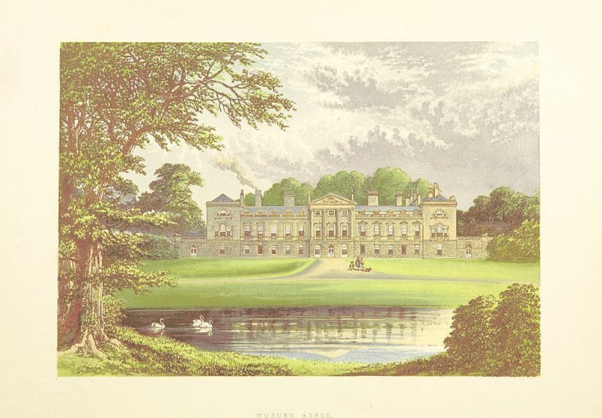
Woburn Abbey is a country mansion surrounded by a medieval deer park and 18th-century landscape park, part of which is now used as wildlife park. There are formal and ornamental gardens adjacent to the Abbey, occupying about 17 hectares in area.
The following is from the Register of Parks and Gardens of Special Historic Interest. For the most up-to-date Register entry, please visit The National Heritage List for England (NHLE):
Extensive and complex park and pleasure grounds around a country mansion. Main phases C18 and early C19, using C17 base, with early C18 work by George London and Charles Bridgeman, and early C19 work by Humphry Repton.
This entry is a summary. Because of the complexity of this site, the standard Register entry format would convey neither an adequate description nor a satisfactory account of the development of the landscape. The user is advised to consult the references given below for more detailed accounts. Many Listed Buildings exist within the site, not all of which have been here referred to. Descriptions of these are to be found in the List of Buildings of Special Architectural or Historic Interest produced by the Department of Culture, Media and Sport.
Location, Area, Boundaries, Landform and Setting
Woburn Park lies on the Greensand Ridge of low hills, adjacent to the village of Woburn to the west and 7km north-east of Leighton Buzzard. The c 1200ha park is bounded to the south-west, north-west and north by the A4012 road from Hockliffe to Ridgmont, and to the east partly by the lane from Ridgmont to Milton Bryan and partly by agricultural land and woodland. Those stretches bounded by roads are enclosed by high, red-brick walls. One c 200m length of wall, situated 1.3km west of the house, is of reduced height, the upper portion being replaced with an iron fence and gates in the form of a clairvoie to give views of the broad, west avenue beyond, known as Wayn Close.
The setting is largely agricultural, with the large wooded expanse of Wavendon Heath and Bow Brickhill woods to the west, and the villages of Woburn, Ridgmont and Milton Bryant lying close to or adjacent to the boundaries. An area of farmland adjacent to The Evergreens wood, outside the north-west boundary, links the enclosed park with Aspley Wood, some 4km north-west of the Abbey. Formerly ornamental woodland, possibly laid out by Humphry Repton, it is now used for mineral extraction with surrounding commercial woodland. Repton's associated C15-style Henry VIII Lodge (1810-11, listed grade II), and small garden, lie at the north-west corner of the wood.
Entrances and Approaches
The main approach to the Abbey enters the park at the southern tip, through the London Entrance (Holland and Repton, 1810-11, listed grade II*), a stone gateway with a tall central carriage arch flanked by smaller pedestrian arches with latticed iron gates, flanked by c 50m long, curving, stone screen walls framing an extensive apron of lawn adjacent to the road.
The drive, laid out by Repton, runs north through the park in almost straight sections, crossing Basin Bridge (Sir William Chambers 1770, listed grade I) 250m south-west of the Abbey, a stone, three-arched bridge separating Basin Pond to the north from New Pond to the south. The drive skirts the east bank of Basin Pond, turning east some 200m west of the Abbey to approach the west front, reaching a broad gravel sweep adjacent to the house, this section of the drive being aligned with Basin Pond and the great avenue west of the Woburn road in Wayn Close. Further major drives, marked by lodges and gateways, curve across the park, entering from Woburn, Husborne Crawley, Ridgmont and Froxfield, the park being bisected by that between Woburn and Froxfield, which is also a public road.
Gardens and Pleasure Grounds
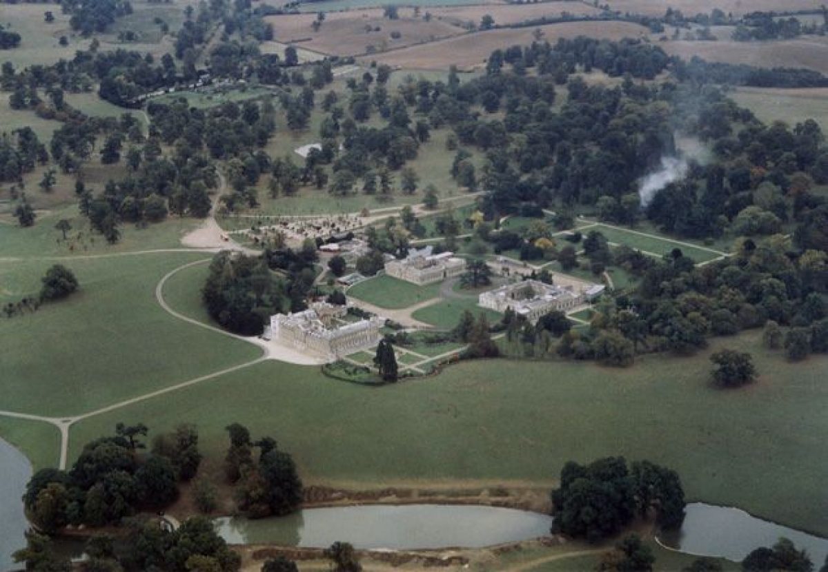
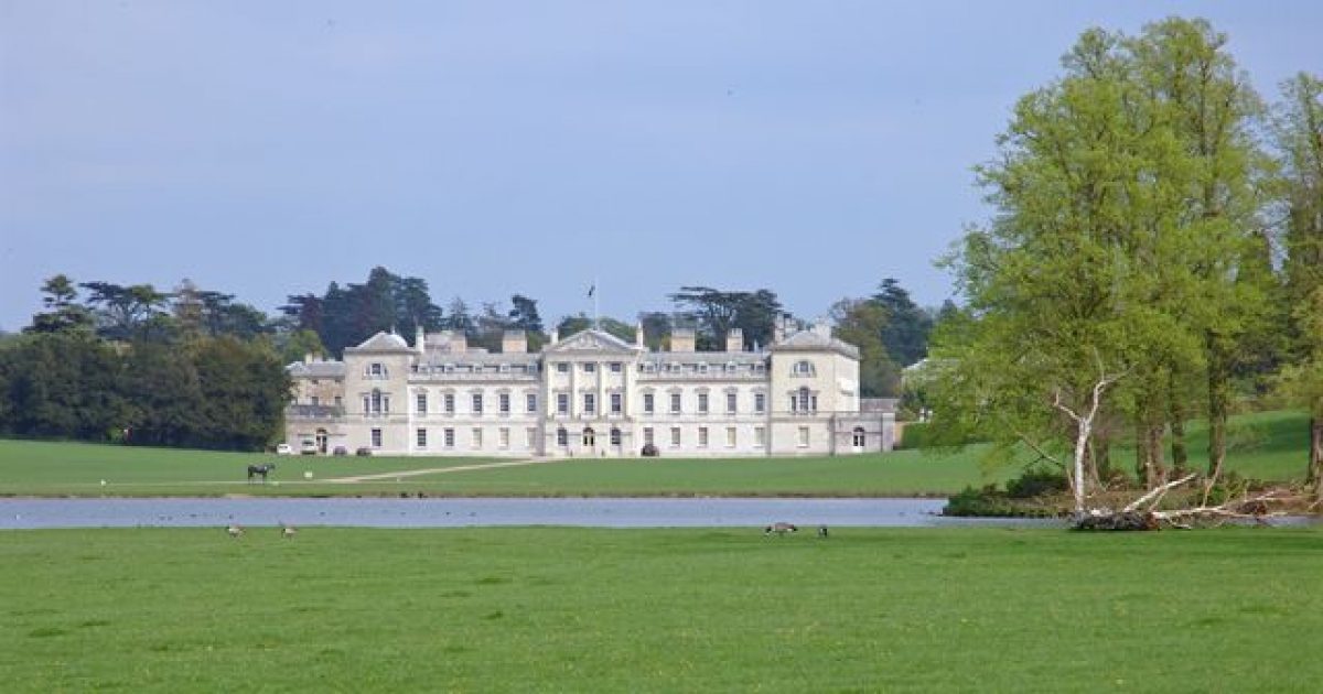
The site consists of gardens, pleasure grounds, extensive parkland and woodland. The mansion (C17/C18, listed grade I), surrounding three sides of a courtyard open to the east, lies towards the centre of the southern half of the site, on the west boundary of the garden and pleasure grounds. The main, west entrance front overlooks parkland, standing at the east end of the great west axis created in the C17 and extended in the early C18. The north front encloses, on the ground floor, the early C17 arcaded grotto room, attributed to Isaac de Caus (Strong 1979). This overlooks the informal Grotto Garden which is enclosed by mature trees, including yews around the boundary.
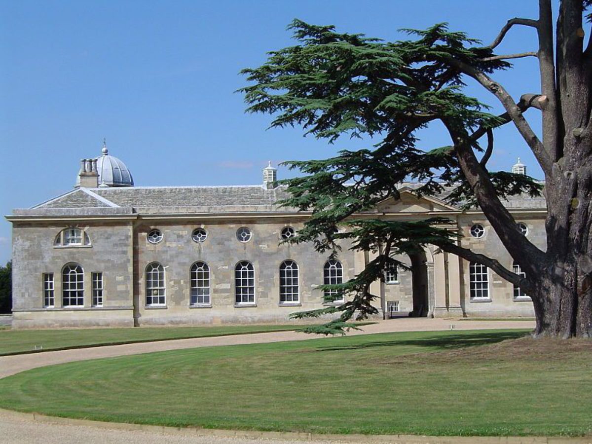
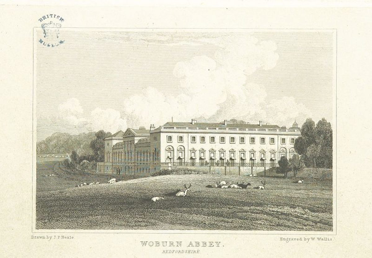
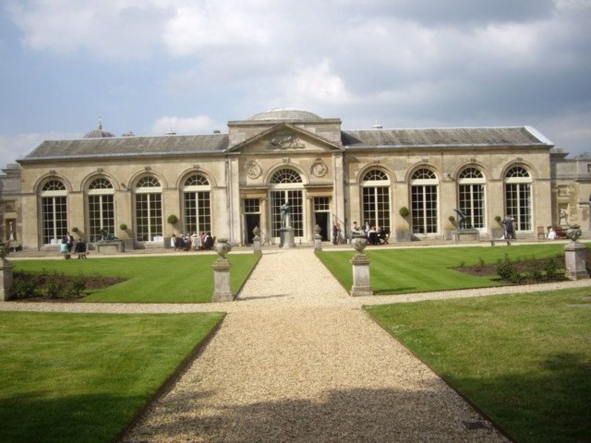
The south, garden front overlooks a formally laid out, square garden which extends east along a straight path, running along the south fronts of the Sculpture Gallery (Holland c 1790, listed grade I) and adjoining Camellia House (Jeffrey Wyatville 1822, listed grade I), both attached to the South Stable Block. This stable block forms a pair with the North Stable Block 75m to the north (both Flitcroft 1750, listed grade I), the two originally flanking the entrance to the main, east front (demolished 1950s), and still enclosing a large courtyard, overlooking the house, with a mature cedar of Lebanon at the centre of an oval panel of lawn.
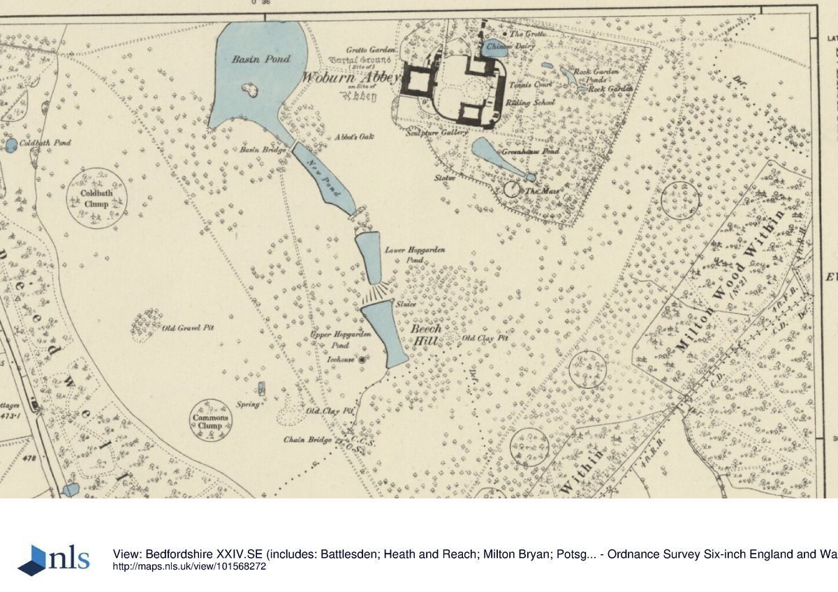
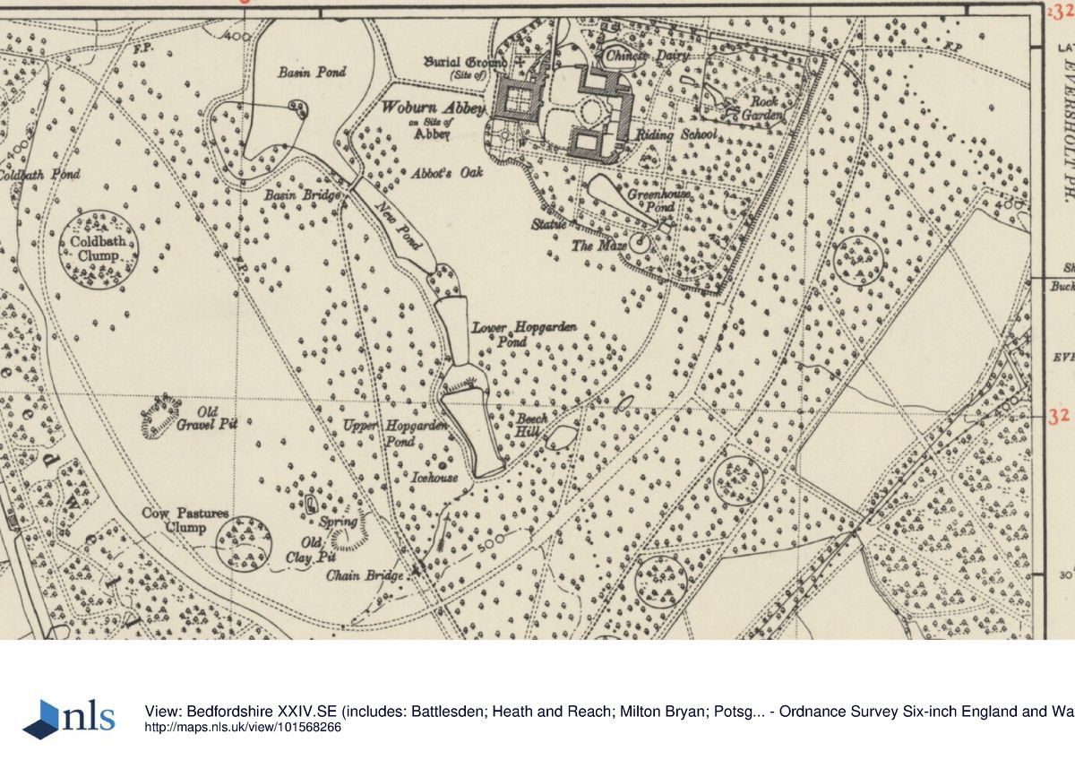
The c 12ha pleasure grounds, remodelled by Repton, consist largely of informal mature woodland and lawns enclosing features such as the Chinese Dairy (Holland 1788, listed grade I) and adjacent pond, the circular hedged maze with its central Chinese Pavilion (1833, based on a 1757 design by Sir William Chambers, listed grade II*), several other garden buildings and seats, a rock garden, cedar avenue and Greenhouse Pond. The area is enclosed by a ha-ha to the south and east, and an iron fence and gates to the north.
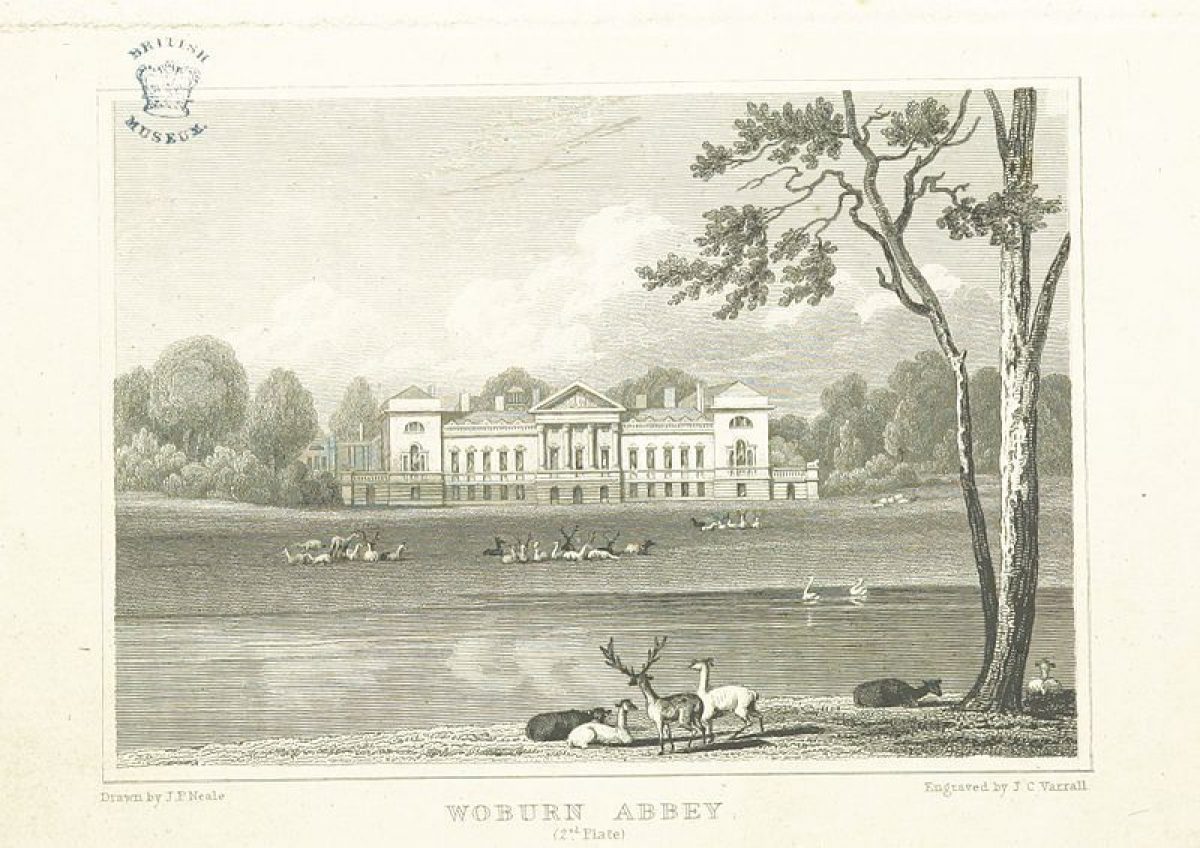
The gardens and pleasure grounds are surrounded by the park, still largely pasture with many single trees and clumps, containing herds of several different species of deer. A series of ponds runs from south to north through the centre of the southern half, dominated by Basin Pond, laid out initially by George London in the early eighteenth century as a formal circular pond, aligned with the west front of the house, with an avenue extending west to the park boundary and beyond. This pond was naturalised by Repton, who included it as part of a chain of informal ponds extending north-west and culminating in Lower Drakeloe Pond, lying 1.5km north-west of the Abbey.
Bisected by the drive from Woburn, the Pond encircles an island with a Chinese Gothic temple (1749, listed grade II). At the centre of the northern half of the park lies the Safari Park, developed mid to late C20, with its own network of drives and paddocks, at the east edge of which stands Repton's Thornery (1808, listed grade II*), a small, rustic thatched cottage used as a summerhouse. The Evergreens, on the north-west boundary, is an extensive area of native and exotic woodland with rhododendron underplanting, laid out in the C18 and extended in the C19.
Maps
- Mapp of the Mannor of Woburn the possessions of Lord Russell, 1661 (Bedfordshire Record Office)
- Plan of the Manor & Parish of Woburn, 1738 (Bedfordshire Record Office)
- T Jefferys, The County of Bedford, 1765
- A Bryant, Map of the County of Bedford, 1826
- Map of Woburn, 1831 (Bedfordshire Record Office)
- OS 6" to 1 mile:
- 1st edition published 1881
- 2nd edition published 1901
- 3rd edition published 1926
- OS 25" to 1 mile: 1st edition published 1880
Description written: September 1997 Amended: April 1999
Register Inspector: SR
Edited: May 1999, July 2022
- Visitor Access, Directions & Contacts
Telephone
01525 290 333Website
https://www.woburnabbey.co.ukAccess contact details
There is currently work happening to reroof the Abbey and therefore Woburn Abbey is closed until the spring of 2024. The rest of the Estate including Woburn Safari Park, Woburn Golf Club and the Deer Park's footpaths remain open.
For more detailed information please visit the Woburn Abbey website.
Directions
Off the A4012, south of M1 junction 13.
- History
The following is from the Register of Parks and Gardens of Special Historic Interest. For the most up-to-date Register entry, please visit The National Heritage List for England (NHLE):
12th - 16th Century
Woburn Abbey, founded in 1145 on the site of the present house, was given in 1547 to Sir John Russell of Chenies (Buckinghamshire), later first Earl of Bedford.
17th Century
In 1619 Francis, Lord Russell, later fourth Earl, established Woburn as the principal family seat, extending the adapted ecclesiastical buildings and, in the 1620s or 1630s, commissioning the Grotto in the new north wing, probably from Isaac de Caus (Strong 1979). By 1661 (Mapp of the Mannor of Woburny, 1661) a series of enclosed gardens had been laid out to the west of the house, within a park enclosing various areas of woodland with straight rides cut through.
18th Century
The park was extended and further formalised by 1738 (Plan of the Manor & Parish of Woburn, 1738), the circular Bason Pond [sic] having been created by George London (d 1714) as part of his grand west approach. Charles Bridgeman (d 1738) was consulted in the 1730s, his work including the removal of much of the formal C17 gardens surrounding the house.
In 1747 the fourth Duke employed Henry Flitcroft (1697-1769) to rebuild the great west range of the house, the fifth Duke employing Henry Holland (1745-1806) to build the south wing in the 1790s to 1800s, together with the Chinese Dairy, Sculpture Gallery and great London Entrance, at the same time as the informal gardens to the east and south were enclosed and developed.
19th Century
The sixth Duke employed Humphry Repton (1752-1818) in 1804, who produced his most splendid Red Book for Woburn in January 1805, with suggestions covering both park and gardens. Repton was employed until at least 1810, although some of his suggested features were not executed or were implemented later in the C19, Woburn being probably his largest and most complete work. The sixth Duke was a keen plant collector, as is reflected in the publication between 1816 and 1833 of several catalogues with extensive lists of plants in cultivation at Woburn, and he also extended the park to its current extent.
20th - 21st Century
The gardens were further developed by Percy Cane c 1930, and in 1955 the house and grounds were opened to the public, with the subsequent development of the safari park in the north park (although a collection of exotic animals has been kept since at least the C19), and other visitor facilities close to the house.
The estate remains (2022) in private ownership.
Period
18th Century (1701 to 1800)
- Associated People
- Features & Designations
Designations
The National Heritage List for England: Register of Parks and Gardens
- Reference: GD1314
- Grade: I
Style
English Landscape Garden
Features
- Boundary Wall
- Description: Those stretches bounded by roads are enclosed by high, red-brick walls.
- Clairvoie
- Description: One length of wall is of reduced height, the upper portion being replaced with an iron fence and gates in the form of a clairvoie.
- Gate Lodge
- Description: 15th-century-style Henry VIII Lodge.
- Earliest Date:
- Latest Date:
- Key Information
Type
Park
Purpose
Ornamental
Principal Building
Domestic / Residential
Period
18th Century (1701 to 1800)
Survival
Extant
Hectares
1200
Open to the public
Yes
Civil Parish
Woburn
- References
References
- Carter, G, Goode, P and Laurie, K {Humphry Repron landscape gardener 1752-1818} (1982) Humphry Repton landscape gardener 1752-1818
- {English Heritage Register of Parks and Gardens of Special Historic Interest} (Swindon: English Heritage 2008) [on CD-ROM] Historic England Register of Parks and Gardens of Special Historic Interest
- Strong, Roy {The Renaissance Garden in England} (1979) pp139-141 The Renaissance Garden in England
- Page, W {Victoria County History: Bedforshire, Volume 3} (Victoria County History, 1912) 458-61 Victoria County History: Bedforshire, Volume 3
- Historic Land Management {Woburn Abbey Park Conservation Statement} (2005) Woburn Abbey Park Conservation Statement
- Vol 117, (31 March 1955), pp 854-8; (14 April 1955), p 987; 138 (8 July 1965), pp 98-102; (15 July 1965), pp 158-61; 173 (31 March 1983), pp 772-5 Country Life
- Dodd, S., (printer) (1845), pp 44-50 Guide to Woburn Abbey