Introduction
Trinity College has enclosed courts, landscaped pleasure grounds and gardens of 10 hectares. The gardens were originally laid out between 1597 and 1605 by Thomas Neville.
Terrain
Flat.Trinity Great Court was laid out between 1597-1605 by Thomas Neville. The stone fountain was erected in his time and is set today within one of six shaped lawns surrounded by paths. David Loggan's etching of 1690 shows the six lawns edged with stone balustrading with taller stone piers at each corner. 'Add to this the ingeniously and delightfully composed variety of climbing plants and you will have some picture of the eminently English diversity of Great Court' (Pevsner).
To the west is Neville Court, built in 1612 and enclosed by Wren's Library in 1676. Here a simple lawn enhances the cloister atmosphere where again according to Pevsner, 'From the Botanical point of view the climbers are even more rewarding'. The Bowling Green, fitting tightly between the College and St. John's College, was laid out in 1647 and now comprises a rectangular lawn, an herbaceous border below the boundary wall and a long high beech hedge. The College still has the original box of bowls.
Loggan also shows a range of small gardens between the college and Trinity Street with elaborate parterres with a range of plants. To the south-east corner of the Chapel is a chequer-board layout of square beds each with a tree or shrub.
Between the College and the river is a short avenue of lime trees planted in 1780 when they were saplings five years old. Three are now missing and some branches have been removed and have lead cappings.
James Essex designed the Cam Bridge in 1746 before the riverside walk was laid out in 1760 and the weeping willows planted by Harrison the Gardener in 1761. The lime avenue replanted in 1949, but set behind a central cherry tree avenue, is underplanted with crocus and red tulips in grass and continues over the bridge to the gates at Queens Road (removed from Horseheath Hall in 1777). The avenue is centred on a vista of Coton church, which is no longer visible today.
To the west of Queens Road is the Fellows' Garden. The garden is protected from the noise of the road by three rows of yews, and is known as the Roundabout, so called after the perimeter path that existed around a field in 1803. In 1871, when the College bought the land, the cornfield disappeared and the informal layout of mixed borders, lawn and specimen trees was undertaken by W. Broderick Thomas (who also worked at Sandringham). Features include the rose garden with a memorial sundial dedicated to three Fellows of the College killed in the First World War; a pattern of paths in the wild flower area attributed to Wittgenstein, a Fellow in the 1930s; and a summer house on a mound erected by a Fellow as a romantic spot in which to propose.
Following the loss of an elm avenue in 1972, Richard Bisgrove redesigned the entrance to the Fellows' Garden with an avenue of plane trees which now links the garden, via a paved octagon, to Burrell's Field. Within a secluded part of the Fellows' Garden is Duffs Garden, originally rented by J.D.Duff, a Fellow in 1889. Here a timber summer house is constructed in a hawthorn hedge, and a mulberry tree has been planted in memory of Tressilian Nicolas (Bursar of the College).
The Fellows' Garden is approximately one-sixth of the College's 36 acre (14.4 hectare) grounds, now extending from Sidney Street to Grange Road. Recently completed is accommodation in Burrell's Field by MacCormac Jamieson and Prichard, set in a landscape designed by Cambridge Landscape Architects. Here, formal pergolas and conical yews link existing houses to the new design, a semi circular lily pool floats over the natural landscape beyond, and by a new bridge golden catalpas are planted amongst agapanthus.
Existing houses overlooking Grange Road have been connected by paths leading to the octagon. Their intimate gardens, a small formal box edged herb garden, and an Arts and Crafts Garden, nestle between extensive lawns under the shade of mature trees.
The following is from the Register of Parks and Gardens of Special Historic Interest. For the most up-to-date Register entry, please visit the The National Heritage List for England (NHLE):
www.historicengland.org.uk/listing/the-list
College courts, landscaped pleasure grounds and gardens, laid out between the 16th and the 19th centuries, including the informal Victorian pleasure ground known as the Fellows' Garden.
DESCRIPTION
LOCATION, AREA, BOUNDARIES, LANDFORM, SETTING
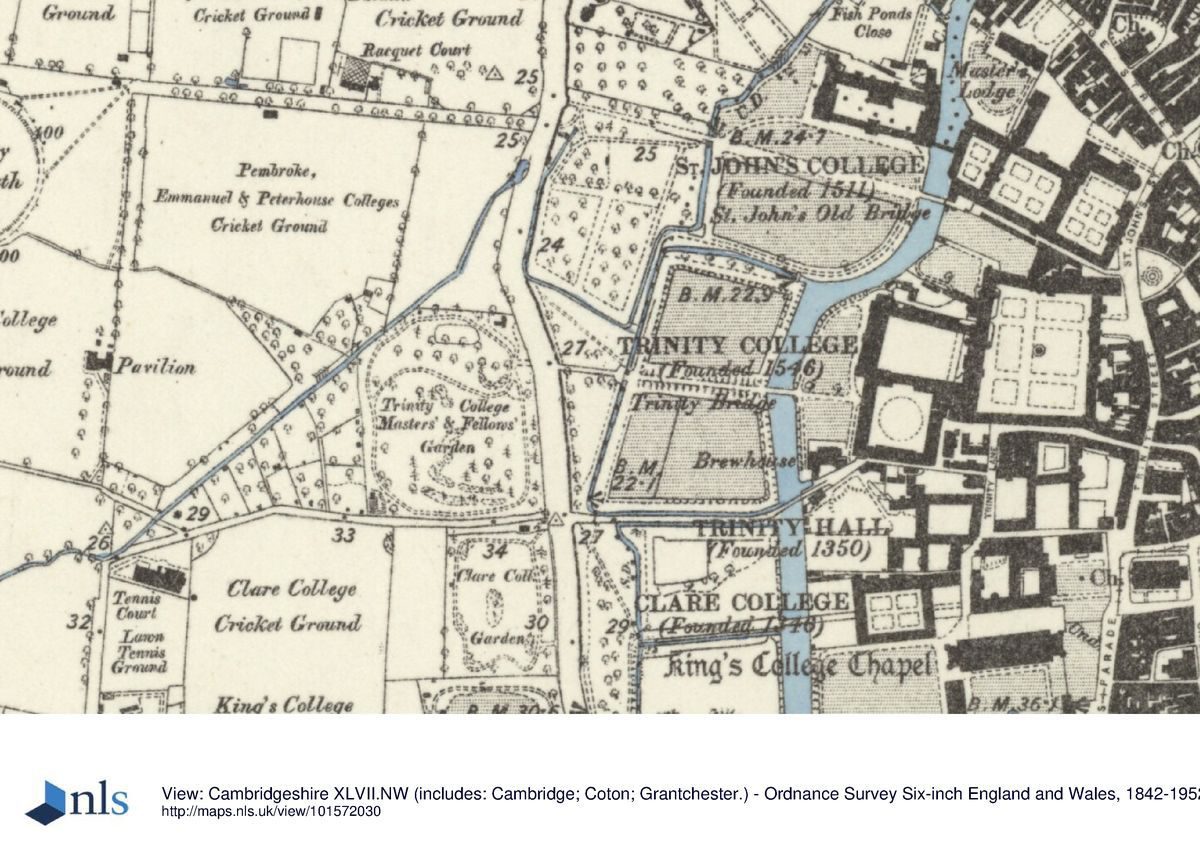
Trinity College lies at the centre of Cambridge, on flat ground crossed by the River Cam and various drainage ditches. The c 9ha college is bounded to the north by St John's College (qv), to the east by Trinity Street and beyond this the city centre, and to the south by Trinity Hall (qv), Clare College (qv) and Gonville and Caius College, divided from them by various drains and Garret Hostel Lane which runs along the length of the college south boundary. Trinity College is set within a group of city-centre colleges, cut from north to south by the river and Queens' Road, the area between these two features forming the centre section of the sequence of five adjacent college gardens and meadows which, taken together, are known as The Backs. In 1779 Lancelot Brown (1716-83) provided a plan to landscape The Backs, including that part of Trinity College west of Nevile's Court. He intended to widen the river into a serpentine lake, and remove the boundaries between individual college grounds together with King's, Clare and Trinity College bridges, using King's College Gibbs Building as the substitute focal point for a great house. This plan was never carried out and The Backs remain individually owned and designed pleasure grounds and gardens.
ENTRANCES, APPROACHES AND COURTS
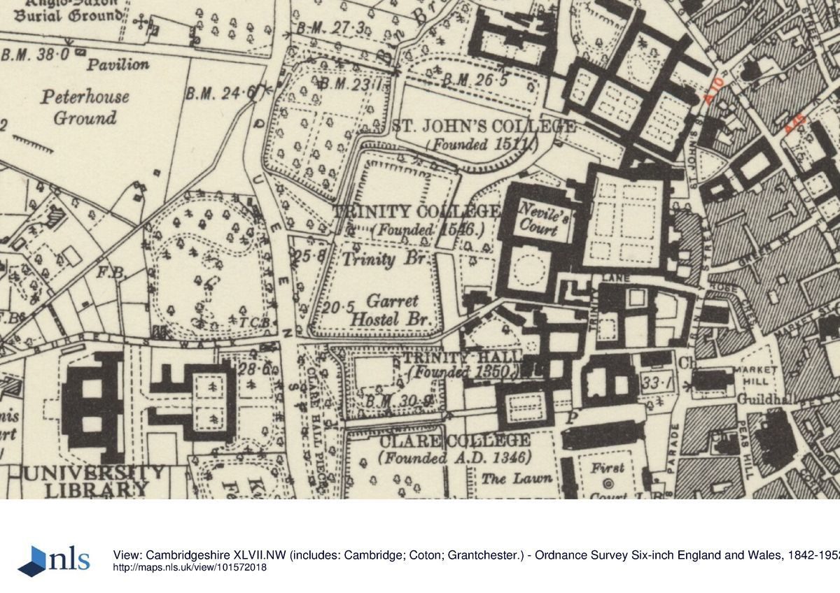
The college is approached at its east end, off Trinity Street, along a short path to the Great Gate gatehouse tower (1518-35), beneath which is the archway giving access into the east side of Great Court (C15-C19, listed grade I). This large court, covering c 2ha, was formed by Thomas Nevile (Master of the college 1593-1615) who demolished many existing buildings to create a coherent space, and moved the clock tower, King Edward's Tower, north to its present position at the centre of the north range. The court contains six unequal, rectangular panels of lawn, divided by cobbled areas with stone paths. At the centre stands a fountain (1602, rebuilt R Grumbold 1716, listed grade I) with raised basins enclosed by a colonnade springing from the top of the main basin, supporting a decorated ogee roof. A simple stone baluster sundial (Troughton of London 1704, listed grade II) stands several metres north of the fountain, marking the site of King Edward's Tower before its removal further north. In the late C17 (Loggan, 1690) the grass panels were edged with balustrade, that around the fountain being five-sided to follow the shape of the fountain's base.
Opposite King Edward's Tower, within the south range, stands the Queen's Gate (c 1597), with a statue of Queen Elizabeth I over the archway, giving access to Trinity Lane to the south. A set of semicircular stone steps leads up to a passage through the west range, past the south entrance to the Hall, giving access to Nevile's Court, emerging at the south-east corner of that court. The doorway emerges onto a raised stone terrace running along the east range (largely consisting of the Hall) of the court. The terrace is edged with a balustrade and contains a triple flight of stone steps down to the perimeter path around the court. A broad central flight of steps stands in front of the Roman Doric Tribunal screen set against the Hall's west wall (Sir Christopher Wren 1682-3, supervised Robert Grumbold, listed grade I as part of the court), and is flanked by two curved flights. The court is laid to lawn with a perimeter path running beneath the north, west and south ranges within a classical cloister. The west range (Sir Christopher Wren 1676-95, supervised Robert Grumbold, listed grade I), known as the Wren Library, contains the library on its upper two storeys, whilst at ground level an open undercroft is supported on Roman Doric columns. The open east side of the undercroft overlooks the court, whilst the west side overlooks the river and The Backs beyond, through wrought-iron screened window openings, with three doorways evenly spaced along the wall. The doorways contain elaborate wrought-iron screens with gates dating from the construction of the range c 1691-2, giving onto the informal lawn between the river and the library range. Both sides of the river bank adjacent to this lawn are planted with several mature weeping willows. In the late C17 (Loggan, 1688) the lawn had not been laid out. It was levelled 1746-7, and turf and gravel walks laid out in 1760. In 1761 payment was made 'to Harrison the Gardner for Planting North-American Poplars, weeping-willows, and other Aquatics, under the wall next the river', an early mention of weeping willows in Cambridge (Architectural Review 1947).
The south range of Nevile's Court is open on the south side, giving onto New Court (William Wilkins 1823-5, listed grade I), in Tudor-gothic style, of three storeys. At the centre lies a circular lawn with a mature specimen tree, surrounded by a gravel drive. An archway through the gatehouse in the east range gives access along a short passage via Nevile's Gate (c 1610, listed grade II*) to Trinity Lane. Nevile's Gate was moved in the late C17 from its original position, before the Wren Library was constructed, at the centre of the old wall bounding the west side of Nevile's Court, which then did not extend as far west (Pevsner 1970). A similar archway in the west range of New Court gives access to the path running west across the river and between the Paddocks to the Master's and Fellows' Gardens on the west side of Queens' Road.
The path from New Court, flanked by a lime avenue with informal lawns on either side, runs 50m west to Trinity Bridge (James Essex 1765, listed grade I), a triple-arched ashlar bridge with a solid parapet wall, replacing at least two earlier structures on the same site (Loggan in 1690 shows the previous structure, built 1651, following the destruction of the first bridge during the Civil War). The path and avenue continue west from the bridge, raised above the surrounding ground, flanked by the North and South Paddocks, two rectangular open lawns with gravel perimeter paths, the whole area bounded by drainage ditches to the north, west and south. The North Paddock contains a level, sunken area of lawn with a raised grass terrace along its east side. From here views extend north across St John's lawns, particularly focused on the New Building and St John's Bridge. Views south are largely interrupted by the adjacent Clare College Fellows' Garden, although from Trinity Bridge there are glimpses of Clare and King's Bridges. In the late C17 (Loggan, 1688, 1690) the Paddocks were laid out in very similar style, with a triple avenue of trees along the central path, and avenues enclosing the perimeter paths, the area referred to as Trinity College Meadow.
The west end of the path is marked by a wrought-iron gateway (from Horseheath Hall, erected 1733 but of earlier date, listed grade I) above a small bridge. The elaborate gateway contains three gates, all with overthrows, and short lengths of flanking railings forming the parapet of the bridge, probably of 1733. The gateways give onto Trinity Pieces, the path continuing west flanked by the North and South Pieces which are laid to informal lawn with specimen trees. Subsidiary paths run to north-west and south-west from the gateway to the road. The main path continues across the road to the main entrance to the Fellows' Garden standing opposite.
GARDENS
The Fellows' Garden is approached across Queens' Road from Trinity Pieces, entered through a set of double wrought-iron gates with an overthrow, brought from Rectory Manorhouse, Enfield, Middlesex, set between modern stone piers (mid C18, erected C20, listed grade II). This gateway stands on an axis with the main path from the college buildings, opposite the gateway between Trinity Pieces and the Paddocks. The entrance lies towards the north-east corner of the Fellows' Garden, laid out informally in 1873 by W Broderick Thomas who also designed the grounds of Sandringham (qv) and Buckingham Palace (qv) (Gray 1984). The Garden is bounded by an informal belt of trees and shrubs, with many evergreens, through which winds a perimeter path, encircling a lawn which is crossed by a path linking the west and east sides of the perimeter path. The lawn contains several island beds planted with trees and shrubs which prevent an open view of the whole garden. A small mound lies close to the entrance, to the south-east, planted with evergreen trees and shrubs enclosing a small summerhouse, with a further sinuous mound (late C20) adjacent to the south side of the cross path. A straight path (late C20) leads west from the garden entrance, flanked by an avenue of trees. This feature stands on the site of an elm avenue lost in the 1970s. A small circular feature with formal beds (late C20) has been laid out south of the mound.
The layout of the Garden is similar to that of the late C19/early C20 (OS 1902), although the path system in the north-west corner has been slightly altered (late C20) to accommodate the paved circle at the west end of the avenue path, and there are fewer specimen trees in the lawn.
The bowling green lies adjacent to St John's College, north of Great Court, approached via a passage through the north range to the west of King Edward's Tower. This enclosed garden is bounded to the north by a high brick wall, overlooked by the south ranges of St John's College, to the east by a range of brick and stone chambers known as King's Hostel (part of King's Hall, C15, listed grade I), to the south by a tall brick and stone wall (medieval and later, listed grade II) which forms the boundary with the Master's Lodge garden, and to the west by the river. The garden contains a rectangular bowling green surrounded by a gravel perimeter path, with, on the south side a tall, clipped beech hedge which prevents views from St John's into the Master's Garden. The south side of the perimeter path runs between the hedge and the boundary wall. At the west end the ground rises up to a terrace, bounded by a low wall, over which extend views of St John's lawns, bridges and New Building, as well as oblique views south-west towards Trinity's own Paddocks. This enclosure was the garden of King's Hall in the C15 and C16, before the college was founded. In the mid to late C16 (Lyne 1574; Hamond, 1592) it appears to have been laid out in two sections, each with its own formal knot enclosed by trees, with a small building at the north end of the riverside boundary. The bowling green was laid out 1647-8 (Willis and Clark 1886), and is shown by Loggan (1688, 1690) in very similar form to now (1998), enclosed by walls, with two low buildings at the riverside.
The Master's Garden to the south of the bowling green seems to have been elaborately laid out during the C16 and C17 (Lyne, 1574; Hamond, 1592; Loggan, 1688, 1690) in a style similar to the bowling green area during the C16, with two sections, each with its own elaborate knot feature, and possibly a viewing mount at the centre of the west section. By the late C17 the garden was laid out in six smaller rectangular sections flanking an axial path leading to the riverside, with a central square gazebo and small circular pond.
REFERENCES
Loggan, Cantabrigia Illustrata (1690)
Beeverell, Les Delices de la Grand Bretagne ... (1707)
R Willis and J W Clark, Architectural History of the University of Cambridge 4, (1886)
Country Life, 18 (4 November 1905), pp 635(41; 61 (19 February 1927), pp 280-6; (26 February 1927), pp 318-26
Architectural Review 50, no 601 (January 1947), pp 13-18
Roy Comm Hist Monuments of Engl Inventories: Cambridge 2, (1952), p 209
Victoria History of the County of Cambridgeshire III, (1959), pp 462-70
N Pevsner, The Buildings of England: Cambridgeshire (1970), pp 161-77
L P Wilkinson, Le Keux's Engravings of Victorian Cambridge (1981)
R Gray, Cambridge Colleges (1984), pp 60-4
M Batey, The Historic Gardens of Oxford and Cambridge (1989)
G M Trevelyan, Trinity College, An Historical Sketch (1990)
Maps
Lyne, Map of Cambridge, 1574
Hamond, Map of Cambridge, 1592
Loggan, Map of Cambridge, 1688 (from Cantabrigia Illustrata, 1690)
Custance, Map of Cambridge, 1798
Baker, Map of Cambridge, 1830
Copy of an old plan in Clare College Treasury showing layout of Fellows' and Master's gardens before C17 rebuilding (in Willis and Clark 1886)
OS 25" to 1 mile: 3rd edition published 1925
OS 1:500: 1st edition published 1888
Description written: February 1998
Register Inspector: SR
Edited: January 2001
- Visitor Access, Directions & Contacts
Access contact details
The site is open daily with occasional exceptions. Please check the website for details.
Directions
Centre of Cambridge city
- History
The following is from the Register of Parks and Gardens of Special Historic Interest. For the most up-to-date Register entry, please visit the The National Heritage List for England (NHLE):
www.historicengland.org.uk/listing/the-list
HISTORIC DEVELOPMENT
Trinity College was founded in 1546 by Henry VIII from two earlier colleges, the King's Hall and Michaelhouse, and various other smaller hostels. Building continued during the 16th and 17th centuries, and Sir Christopher Wren (1632-1723) was commissioned to design the library which was built from the 1670s to the 1690s, with further development during the 19th century. The site remains (1998) in college use.
Period
- Post Medieval (1540 to 1901)
- Tudor (1485-1603)
- Associated People
- Features & Designations
Designations
The National Heritage List for England: Register of Parks and Gardens
- Reference: GD1624
- Grade: II
Features
- Ornamental Bridge
- Earliest Date:
- Latest Date:
- Ornamental Fountain
- Summerhouse
- Sundial
- Tree Avenue
- Description: A Lime avenue planted in 1780
- Earliest Date:
- Lawn
- Rose Garden
- Specimen Tree
- Pergola
- Pond
- Bowling Green
- Earliest Date:
- Latest Date:
- College (featured building)
- Earliest Date:
- Latest Date:
- River
- Description: River Cam.
- Key Information
Type
Garden
Purpose
Ornamental
Principal Building
Education
Period
Post Medieval (1540 to 1901)
Survival
Reconstructed
Hectares
9
Open to the public
Yes
- References
References
- Cambridgeshire Gardens Trust {The Gardens of Cambridgeshire} pp 3-4 The Gardens of Cambridgeshire
- {English Heritage Register of Parks and Gardens of Special Historic Interest} (Swindon: English heritage 2008) [on CD-ROM] Historic England Register of Parks and Gardens of Special Historic Interest
- Pevsner, N {The Buildings of England: Cambridgeshire} (Harmondsworth: Penguin, 1970) pp 161-177 The Buildings of England: Cambridgeshire
- Batey, M., {The Historic Gardens of Oxford and Cambridge} (London: Macmillan London, 1989) The Historic Gardens of Oxford and Cambridge
- Roach, J.P.C. {Victoria County History: Cambridgeshire and the Isle of Ely, Volume 3} (Oxford: Oxford University Press, 1959) 462-70 Victoria County History: Cambridgeshire and the Isle of Ely, Volume 3
Contributors
Cambridgeshire Gardens Trust