Introduction
Two large lawns to the east and west of the Fellows' Building distinguish King's from other colleges. In the centre of the east lawn stands a fountain with bronze figures by H A Armstead (1874). The garden features herbaceous perennials and a wide range of specimen trees.
Terrain
Flat ground crossed by the River Cam and various drainage ditches.In 1627, between the river and the entrance there were unequal plots of grass divided by straight avenues and crossed diagonally by footpaths; along the river ran a wall, and in the north-west part of the ground was a bowling green. West of the river the land was divided in two by a raised walk flanked by water courses and double rows of trees. In the thickly planted southern division, called King's Grove, was an oblong island surrounded by a moat.
Bridgeman's plan of 1724, 'improvement by cutting vistas through the Grove and laying out the waste ground in regular walks and canals', was only partly implemented. In 1741 James Essex published his 'Prospect of King's College' showing a formal layout with the symmetrical basin carved out on the west side of the river and a circular temple terminating the vista. Again the College made no attempt to implement Essex's 'Prospect'.
The layout of the grounds remained substantially unchanged from Loggan's map until 1749, when a new walk along the west bank of the river was begun. By 1751 the walk had been turfed and planted with limes and a second new walk had been made along the south side of the ground on the east bank. William Custance's map of 1798 shows the Fellows' Building by Gibbs (1723) overlooking a vast sloping lawn to the river edged by a perimeter path, with the central bridge leading to an avenue of trees to the west.
This formality was abandoned in 1818 when the land to the west of the river was altered by making two mounds set on the lines of the former avenue. A new bridge by Wilkins was erected to the south of the original bridge, and the gate to Queens' Road erected by Wilkins in 1819. From the Backs Gate a path winds beneath trees to the new bridge without giving any clue of the vista that is in store.This element of surprise when reaching the bridge offers superb views to the College buildings and Clare College.
In 1823 Wilkins won a competition for the design of the hall and screen along the Trumpington Road entrance, which encloses the main court. Today the two large expanses of the lawn to the east and west of the Fellows' Building distinguish King's from other Colleges. In the centre of the east lawn stands a fountain with bronze figures by H. A. Armstead (1874).
To the west of Queens' Road is the Fellows' Garden which was laid out in the early 1850s. The garden has a perimeter walk through evergreens and two large island plantings of specimen trees, which include a 140 year old Wellingtonia, a Chinese Thuya and the best example of a Golden Rain Tree in Cambridge. A further island bed of herbaceous perennials divides the garden, and successfully maintains its Victorian atmosphere. The tall Wellingtonia in the Fellows' Garden balances the fine specimen horse chestnut immediately to the east of the King's Chapel.
The following is from the Register of Parks and Gardens of Special Historic Interest. For the most up-to-date Register entry, please visit the The National Heritage List for England (NHLE):
www.historicengland.org.uk/listing/the-list
College courts, landscaped pleasure grounds and gardens, laid out from the 18th to the 20th century, including the informal Victorian pleasure ground known as the Fellows' Garden.
DESCRIPTION LOCATION, AREA, BOUNDARIES, LANDFORM, SETTING
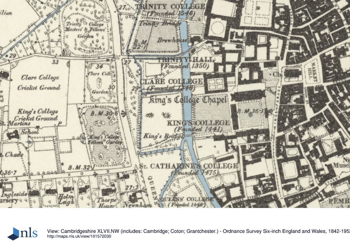
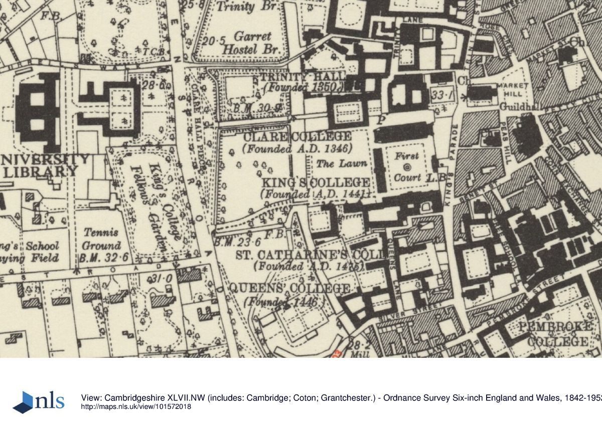
King's College lies at the centre of Cambridge, on flat ground crossed by the River Cam and various drainage ditches. The c 6ha college is bounded to the north by Clare College (qv), to the east by King's Parade and beyond this the city centre, and to the south by Queens' College (qv), St Catharine's College and Queens' Green. King's College is set within a group of city-centre colleges, cut from north to south by the river and Queens' Road, the area between these two features forming the centre section of the sequence of five adjacent college gardens and meadows which, taken together, are known as The Backs. In 1779 Lancelot Brown (1716-83) provided a plan to landscape The Backs, including that part of King's College west of the Gibbs Building. He intended to widen the river into a serpentine lake, and remove the boundaries between individual college grounds together with King's, Clare and Trinity College bridges, using the Gibbs Building as the substitute focal point for a great house. This plan was never carried out and The Backs remain individually owned and designed pleasure grounds and gardens.
ENTRANCES, APPROACHES AND COURTS
The college consists largely of a linear series of adjacent open spaces, connected by a path entering at King's Parade in the east and running 350m west, around Front Court, across the south side of Back Lawn and Scholars' Piece to Queen's Road. The college is approached from the east, off King's Parade, along a short path flanked by open lawns, arriving at the gatehouse centrally placed within William Wilkins' gothic-revival stone screen (1842-48, listed grade I), giving onto Front Court to the west. Front Court is laid to lawn, surrounded by a perimeter path and bounded to the north by Henry VI's chapel (C15-C16, listed grade I) which dominates the Court, to the east by Wilkins' screen, to the south by his south range (1824-8, listed grade I), and to the west by the Gibbs Building (J Gibbs 1724-31, listed grade I) with its central, open-arched gatehall giving views of Back Lawn and Scholars' Piece beyond. At the centre of the lawn stands a stone basin with a central fountain supporting a bronze statue of Henry VI (H A Armstead 1879, listed grade II). The south side of Front Court's perimeter path continues west along the south side of Back Lawn, forming part of the perimeter path which encircles the open rectangular lawn running down to the river, with views across Scholars' Piece and Clare College gardens and bridge to the north. The south range of Clare College's Old Court forms much of the north boundary of this lawn, which it overlooks. The path reaches the single-arched, ashlar King's Bridge (W Wilkins 1818, listed grade I), standing 100m west of the Gibbs Building, at the south-west corner of Back Lawn, connecting Back Lawn with Scholars' Piece, with views north to Clare Bridge and south to Queens' College bridge. South of this corner stands Bodley's Court, surrounded to the east and south by Bodley's Buildings (G F Bodley 1890-3, listed grade II), overlooking the river and bridge, and largely laid to lawn with a central north/south path and a stone-paved landing stage adjacent to the river.
The path continues west from the bridge in a serpentine line along the south boundary of Scholars' Piece, flanked by a lime avenue, raised above the level of the adjacent meadow and overlooking Queens' Green to the south. It seems to have been designed with the approach from the west in mind, the curved path with its flanking avenue being planned to conceal the buildings across Back Lawn until they are dramatically revealed across the bridge. Scholars' Piece is an open meadow with scattered trees, surrounded by drains, with two mounds in it dating from landscaping work c 1818-20s. The path terminates at the entrance off Queens' Road, c 300m south-west of the Gibbs Building, marked by a rusticated stone gateway (W Wilkins 1818, listed grade II*) standing on a small bridge above the drain which forms the west boundary of Scholars' Piece. The gateway, containing a central arch flanked by two smaller arches, supports wrought-iron gates with an overthrow and coat of arms.
By the late C17 (Loggan, 1688) the land east of the river (now divided into Front Court and Back Lawn) consisted largely of a large open lawn, Chapel Yard, dominated in the north-east corner by the chapel, and crossed at right angles by two central paths in cruciform pattern. The path from the east entrance led west across the river via a central bridge, and separated what is now Scholars Piece into King's College Meadow to the north and King's Grove to the south.
From 1724 the Gibbs Building divided Chapel Yard lawn into Back Lawn to the west and Front Court to the east. At the same time Charles Bridgeman (d 1738) was asked to provide a design for the land west of the river to complement Gibbs' country-house-like building. He suggested a formal basin at the centre of the area, leading off the canalised river, with a raised circular temple at the far side of a central vista, aligned with the centre of the Gibbs Building, and with views of the countryside beyond. This was never implemented (Batey 1989).
In 1771 Back Lawn was freed of bowling green walls and other enclosures, levelled and laid to an open lawn surrounded by a perimeter path, this work being directed by James Essex. Front Court was not completed until 1828 when William Wilkins' gatehouse and screen were finished, together with the south range projecting west towards the river. (Wilkins had intended his screen to support a cloister along the inner face, which was never built.). As part of Wilkins' scheme the central bridge over the river was replaced further south by the present bridge, and Back Lawn was graded so that it sloped down to the river, giving it its present landscaped appearance. Scholars' Piece was also landscaped, and the serpentine path to the bridge constructed across it. Several further buildings were erected during the later C19 and C20 in the area south of Front Court and Back Lawn.
GARDENS
The main Fellows' Garden lies adjacent to the west boundary, entered off Queens' Road opposite the back gate from Scholars' Piece, c 300m south-west of the Gibbs Building. It is physically isolated from the main college grounds, being bounded by Queens' Road to the east, Clare College Memorial Court grounds to the north, sports grounds to the west, and West Road to the south. The rectangular garden, surrounded by perimeter belts including many evergreen shrubs and trees, contains several large specimen plane trees. The perimeter belt encircles an informal lawn, with serpentine edges formed by the undulating inner edge of the belt, on which lie several informal shrub beds, also planted with ornamental trees. The shrub beds break up the openness of the lawn: one lies in front of the path through the belt from the Queens' Road entrance, preventing an open view of the garden; a second, larger bed lies at the centre of the lawn, and a third bed lies towards the north end adjacent to the bottom of a low bank supporting an open croquet lawn at the north end. The trees include some fine examples of exotic species, some planted c 1850 or earlier, including Sequoiadendron giganteum, Platanus orientalis, Quercus x hispanica and Catalpa bignonioides.
The early Fellows' Garden lay towards the north-west corner of Back Lawn before it was laid out in the 1770s and the small, enclosed garden was destroyed. The addition of the Provost's Lodge south of Back Lawn prompted, in 1836, the removal of the Provost's stables across the river to what is now the Fellows' Garden. At the same time the perimeter of what had been a field on the west side of Queens' Road was planted up and a walk made through the plantation, for the use of the Provost and Fellows, whilst the walk was screened by an iron fence from the interior paddock which accommodated the Provost's four carriage horses. In 1851 it was agreed that the whole area should be laid out as a pleasure ground for the Fellows, and this was done, resulting in an informal design much as remains today (1998). Although no planting plan survives, in 1904 A A Tilley produced a printed list of trees and shrubs in the gardens and grounds, which includes most of the older trees still in existence.
The Provost's Garden lies south of the former Provost's Lodge (W Wilkins 1824-8, listed grade I) which forms the south range of Back Lawn. It is reached from the west, garden front of the current Provost's Lodge which forms its east boundary. The garden is enclosed to the west by the east range of Bodley's Court and to the south by the boundary wall with Queens' College. It is laid largely to lawn, with a broad grass terrace running along the east side adjacent to the current Provost's Lodge supported by a low stone wall with central steps down to the main lawn, largely surrounded by shrubs. Another, narrower, grass terrace runs along the south front of the former Provost's Lodge.
REFERENCES
Loggan, Cantabrigia Illustrata (1690) Beeverell, Les Delices de la Grand Bretagne ... (1707)
Country Life, 60 (11 December 1926), pp 930-6
Architectural Review 50, no 601 (January 1947), pp 13-18
Victoria History of the County of Cambridgeshire III, (1959), pp 376-93
N Pevsner, The Buildings of England: Cambridgeshire (1970), pp 91-101
P Willis, Charles Bridgeman and the English Landscape Garden (1977), pp 84-5
R Gray, Cambridge Colleges (1984), pp 32-5
M Batey, The Historic Gardens of Oxford and Cambridge (1989), pp 111-12, 114-15, 121-3, 179
S M Walters, King's College Fellows' Garden (1991)
Maps
Lyne, Map of Cambridge, 1574
Hamond, Map of Cambridge, 1592
Loggan, Map of Cambridge, 1688 (from Cantabrigia Illustrata 1690)
Custance, Map of Cambridge, 1798
Baker, Map of Cambridge, 1830
OS 25" to 1 mile: 3rd edition published 1925
OS 1:500: 1st edition published 1888
Description written: February 1998
Amended: February 1999
Register Inspector: SR
- Visitor Access, Directions & Contacts
Access contact details
The College grounds are open to the public and the Fellows' Garden is usually open as part of the National Gardens Scheme one Sunday afternoon in mid-July. Please see: http://www.kings.cam.ac.uk/visit/admission.html 01 223 331100
Directions
Centre of Cambridge city. Please see: http://www.kings.cam.ac.uk/visit/getting-to-kings.html
Owners
University of Cambridge
- History
King's College was founded by Henry VI in 1441. Loggan's map of 1688 shows the college hidden behind buildings along Trumpington Road. King's Bridge built in 1627 crossed the river mid-way between the boundaries of Queens' and Clare Colleges.
The following is from the Register of Parks and Gardens of Special Historic Interest. For the most up-to-date Register entry, please visit the The National Heritage List for England (NHLE):
www.historicengland.org.uk/listing/the-list
HISTORIC DEVELOPMENT
King's College was founded in 1441 by Henry VI, who had founded Eton College in 1440 and subsequently linked the school to King's in order to supply college scholars. King's College chapel was begun in 1446. Following Henry's deposition in 1461, the college's income was much reduced, and the only building of his great scheme to be built was the chapel, which took about a century to complete. The initial court, Old Court, was built north of the chapel (this area, since 1829, part of the Old Schools precinct owned by the University), with the intention that it should be superseded by the great scheme, of which the chapel would have been the north side of the resultant court. Building was slow and piecemeal throughout the following centuries, Front Court not being finished until the early 19th century. The site remains (1998) in college use.
- Associated People
- Features & Designations
Designations
The National Heritage List for England: Register of Parks and Gardens
- Reference: GD1615
- Grade: II*
Features
- Fountain
- Description: A fountain with bronze figures
- Earliest Date:
- Latest Date:
- College (featured building)
- Description: Kings College was founded in 1441 by Henry VI.
- Earliest Date:
- Latest Date:
- Lawn
- Herbaceous Border
- Specimen Tree
- Key Information
Type
Garden
Purpose
Ornamental
Principal Building
Education
Survival
Extant
Hectares
6
Open to the public
Yes
- References
References
- Cambridgeshire Gardens Trust {The Gardens of Cambridgeshire} pp 6-7 The Gardens of Cambridgeshire
- {English Heritage Register of Parks and Gardens of Special Historic Interest} (Swindon: English Heritage 2008) [on CD-ROM] Historic England Register of Parks and Gardens of Special Historic Interest
- Willis, P {Charles Bridgemen and the English Landscape Garden} (1977) pp 84-85 Charles Bridgeman and the English Landscape Garden
- Pevsner, N {The Buildings of England: Cambridgeshire} (Harmondsworth: Penguin, 1970) pp 91-101 The Buildings of England: Cambridgeshire
- Batey, M., {The Historic Gardens of Oxford and Cambridge} (London: Macmillan London, 1989) pp 111-112, 114-115, 121-123, 179 The Historic Gardens of Oxford and Cambridge
Contributors
Cambridgeshire Gardens Trust