Introduction
The gardens of St John's College, which occupy about 5 hectares, follow a similar layout to many of the other Cambridge colleges. The gardens are divided into large lawned areas known as the courts: First Court, Second Court, Third Court and Merton Court, most of which are bisected by paths. The gardens also feature separate, more enclosed areas: The Master's Garden, The Fellows' Garden and the Scholars' Garden. Of particular note is the 'Bridge of Sighs' which connects New Court to Third Court.
Terrain
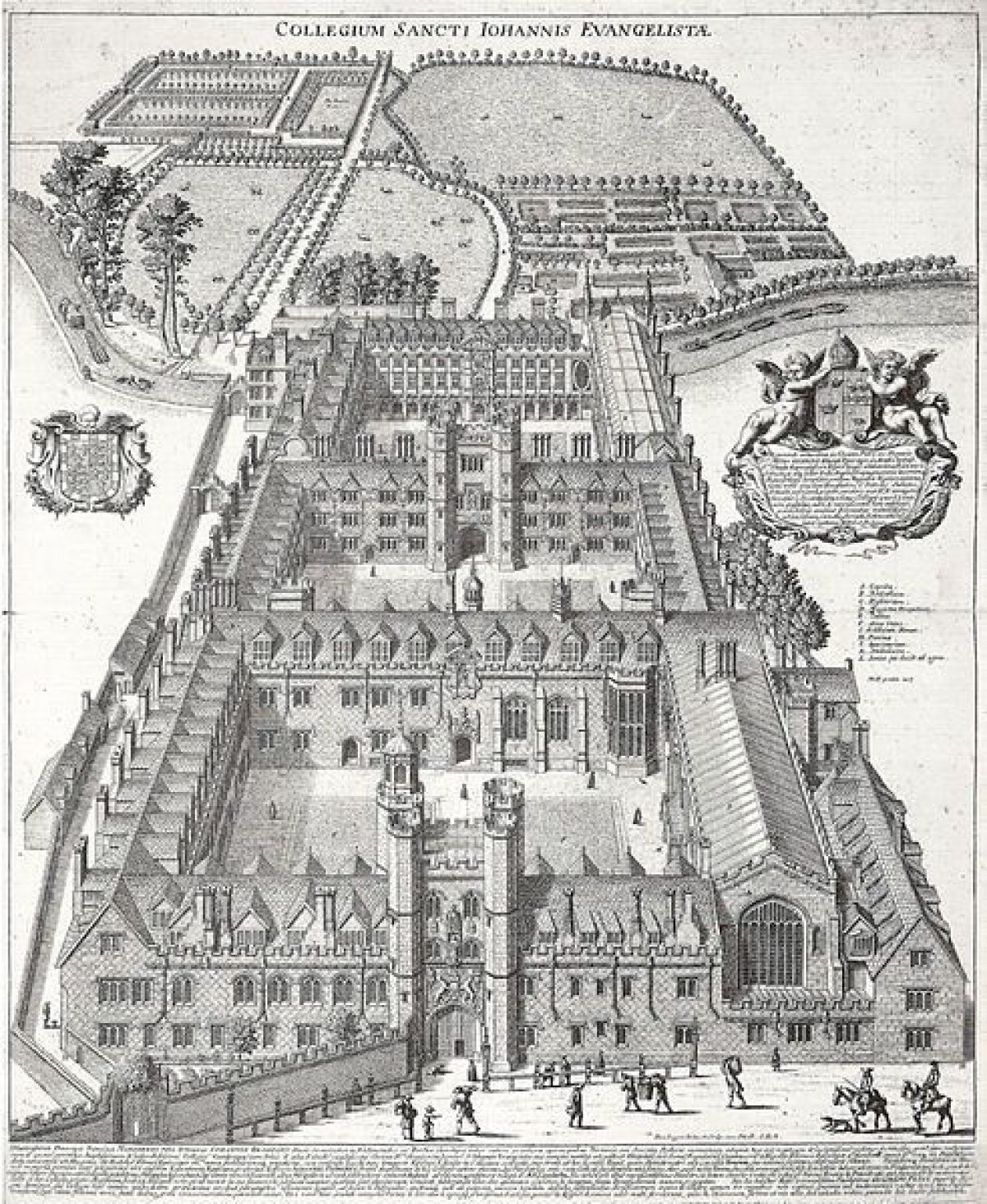
Flat.David Loggan's view of St. John's College, around 1690, shows the three enclosed courts to the east of the river all laid out on an axis, with grass lawns surrounded and crossed by paths. To the west of the river the College owned extensive land which at that time consisted of a High Walk bordered by trees extending over the Bin Brook, (elegant cast-iron bridge created about 1822) to the gateway at Queens' Road.
South of this walk was a formal garden for the Fellows with hedged paths, with seating recesses and lined with trees planted in lawns and nearby a bowling green. Immediately to the north of the walk was a walled enclosed real tennis court, extensive fishponds and a large field for grazing cattle.
In 1765 Charles Miller (son of Philip Miller, head gardener at the Physic Garden, Chelsea) was paid 'two guineas for his advice and plans for the improvements for the gardens'. By February 1773, Dr. William Powell, Master of the College was concerned at the expense of 'new-casing of the first Court and the laying out their Gardens under the direction of the celebrated Mr. Brown who had told him that his plan would cost them at least 800 pounds'.
In the previous year, records mention that it was 'ordered that the bank be repaired under the direction of Mr Brown'. In 1778, it was 'agreed that a piece of plate of the value of 50 pounds be presented to Mr Brown, for his services in improving the walks'. Lancelot Brown's improvements involved the simplification of the formal walks in the Fellows' Garden, with dense planting of trees and enlarging the Bowling Green into a spacious lawn. This area is now known as The Wilderness. Access to the Backs is through the wrought iron gates (which were removed from Horseheath Hall in 1777). Today there are spring bulbs flowering in drifts under the trees which are followed later by naturalised martagon lilies and the outer walk has box brushes at regular intervals. The Bowling Green is now a croquet lawn with a small pavilion.
Opposite The Wilderness is the Scholars' Garden, laid out to plans by Dame Sylvia Crowe in 1952, with yew hedges enclosing a rectangular garden with a central pavilion. The garden is edged with shrub and herbaceous borders and the six island flowerbeds have now been replaced by clumps and junipers.
To the north of the College, the Master's Garden overlooks the river and is dominated by a large plane tree and a chestnut both planted around 1868. The terrace is thickly planted with herbaceous perennials. Overlooking the river is a formal rose garden enclosed by yew hedging.
The following is from the Register of Parks and Gardens of Special Historic Interest. For the most up-to-date Register entry, please visit the The National Heritage List for England (NHLE):
www.historicengland.org.uk/listing/the-list
College courts, landscaped pleasure grounds and gardens, laid out C17-C20.
DESCRIPTION
LOCATION, AREA, BOUNDARIES, LANDFORM, SETTING
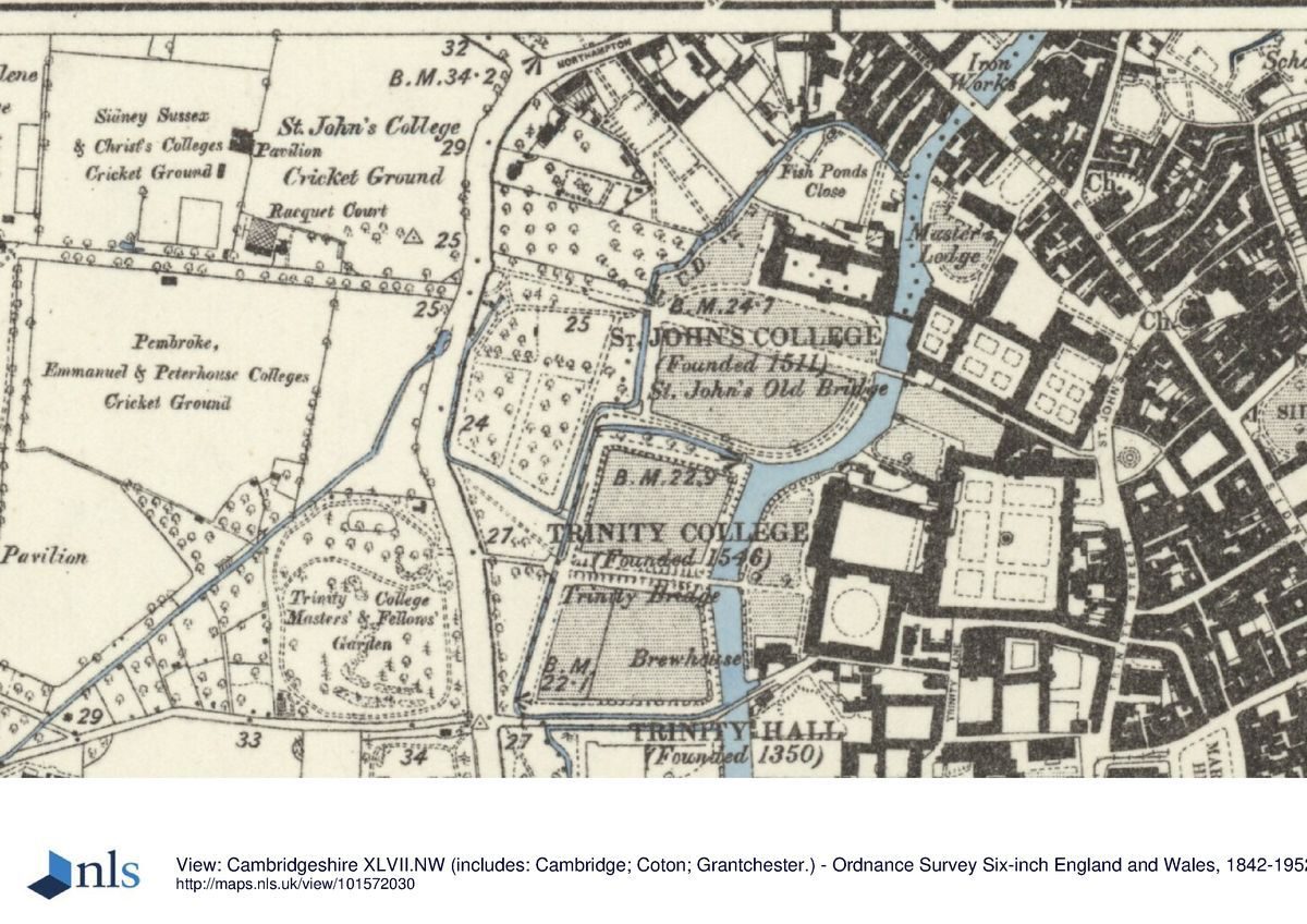
St John's College lies at the centre of Cambridge, on flat ground crossed by the River Cam and various drainage ditches including the Bin Brook. The c 9ha college is bounded to the north by domestic and commercial buildings and Bridge Street, to the east by St John's Street and beyond this the city centre, and to the south by Trinity College (qv). To the west is Queens' Road and beyond this the college playing fields. St John's College is set within a group of city-centre colleges, cut from north to south by the river, the area to the west forming the northern section of the sequence of five adjacent college gardens and meadows which, taken together, are known as The Backs. In 1779 Lancelot Brown provided a plan to landscape The Backs, including that part of St John's west of Third Court. He intended to widen the river into a serpentine lake, and remove the boundaries between individual college grounds together with King's, Clare and Trinity College bridges, using King's College Gibbs Building as the substitute focal point for a great house. This plan was never carried out and The Backs remain individually owned and designed pleasure grounds and gardens.
ENTRANCES, APPROACHES AND COURTS
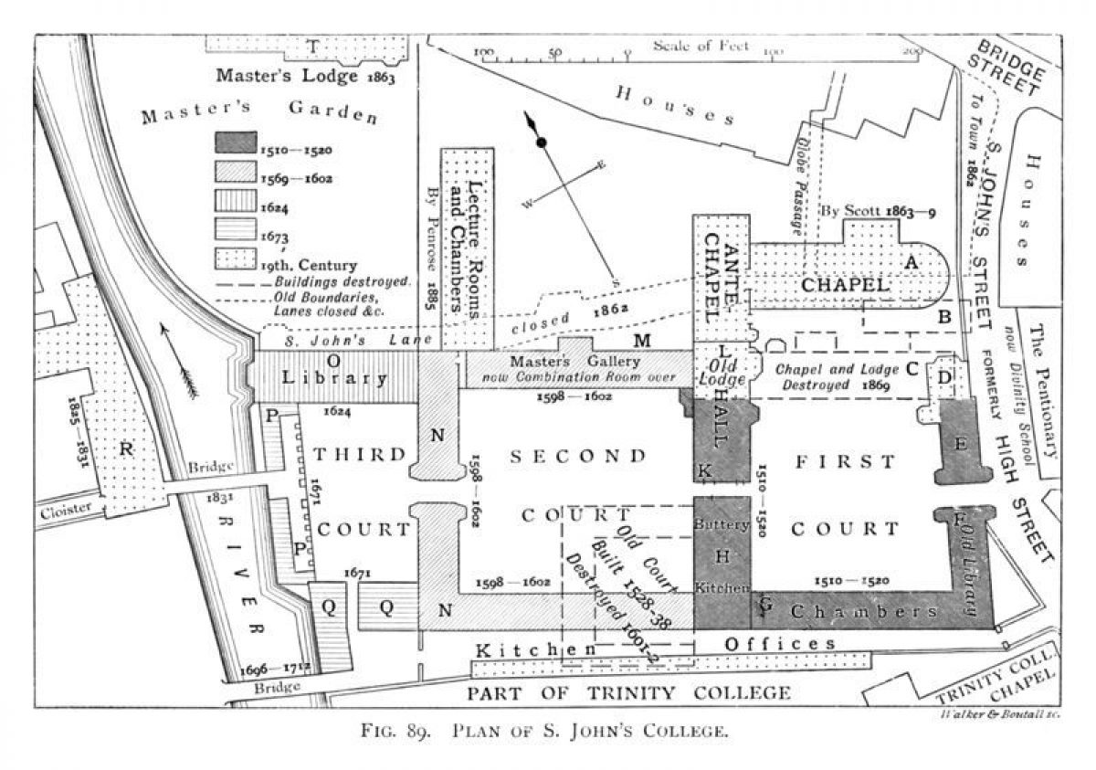
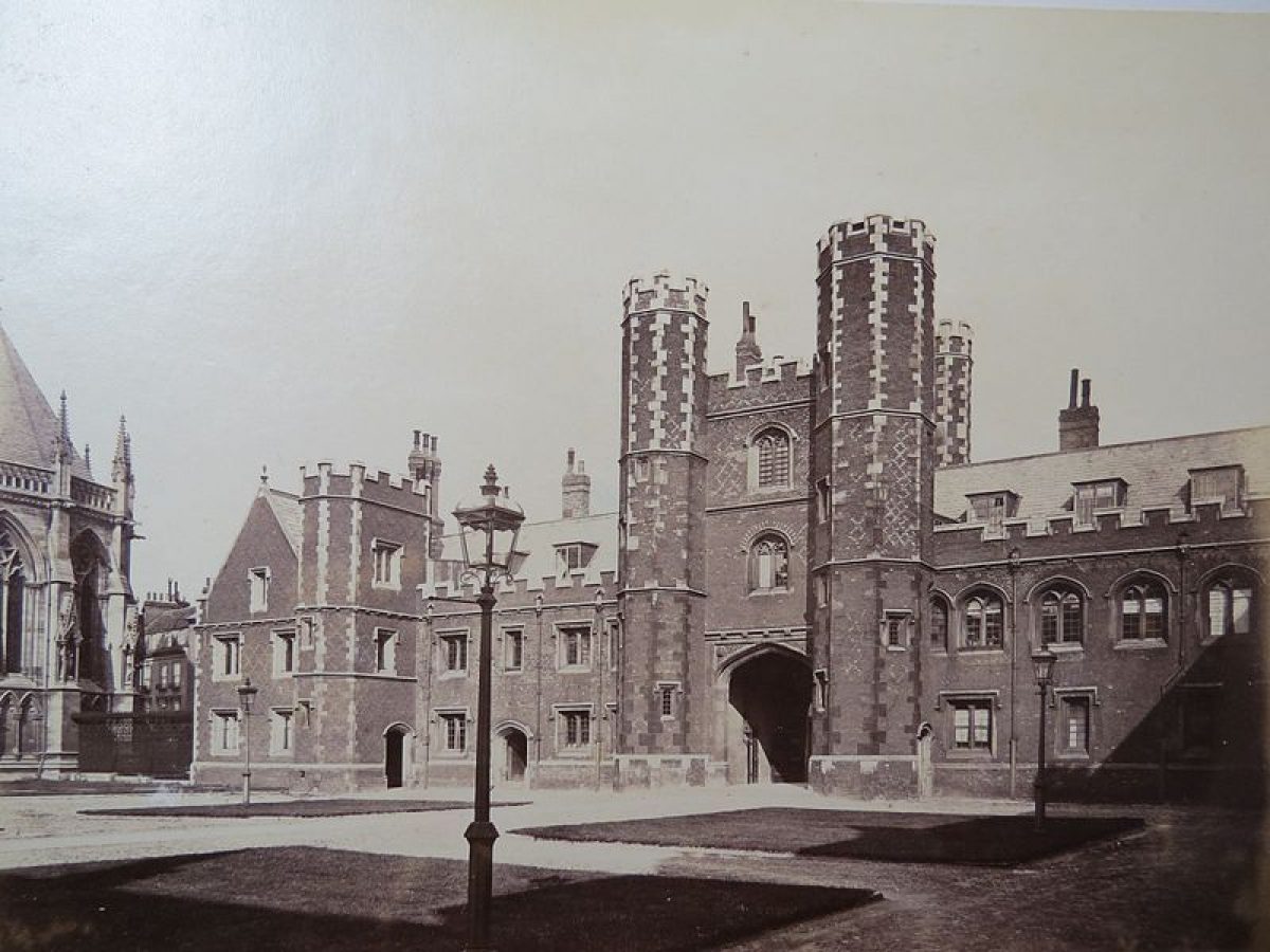
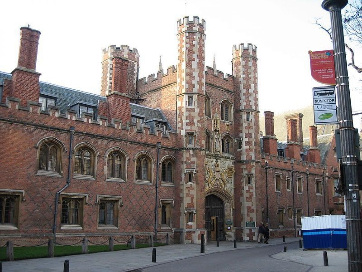
The college is approached at its east end, straight off St John's Street, through Front Gate beneath the Gate Tower (1511-20), giving access to the east side of First Court (1511-20, listed grade I). The court contains two panels of lawn divided by the axial path running west from the Gate Tower which links First, Second and Third Courts. The foundations of the medieval chapel are visible in the north panel, to the north of which stands the C19 chapel (Sir Gilbert Scott 1863-9, listed grade I) built in C13 Gothic style, dominating the court and its surroundings with its massive tower.
A passage through the west range of First Court emerges into Second Court (C17, listed grade I), enclosing panels of lawn divided by two central cruciform paths. The axial path continues west, through the archway beneath the Shrewsbury Tower in the west range into the smaller Third Court (1620s and 1670s, listed grade I). North of Second Court stands Chapel Court, and to the north of this North Court (both late C19-C20), bounded on its open north side by an iron screen, opening onto Bridge Street beyond.
Third Court encloses two panels of lawn divided from west to east by the axial path. The west range contains an arcade, open into the court at ground level, and is bounded by the river to the west. A passage through this range leads to the New Bridge (H Hutchinson 1827, listed grade I) or Bridge of Sighs (on which it was modelled), a single-span stone bridge with a highly decorative neo-gothic covered footway which gives direct access to the east end of New Court cloister.
A passage through the south range of Third Court gives onto a disused lane between St John's and Trinity Colleges, close to the entrance to St John's off this lane which is marked by two tall stone gate piers surmounted by stone eagles, the college emblem (mason Robert Grumbold 1711-12, listed grade I). The old lane to the east is now blocked by college buildings. The westward continuation of the lane crosses the river via the three-arched, stone Old Bridge, or Wren Bridge (to designs by Wren, built 1709-12, listed grade I). The entrance to the east side of the bridge is marked by two tall stone gate piers, surmounted by Yales (mythical gazelle-like beasts, the emblem of Lady Margaret Beaufort), supporting wrought-iron gates and overthrow (mason probably Robert Grumbold 1712, listed grade I), the piers in similar style to those close by to the north. The balustraded parapet contains panelled pedestals, the panels containing carvings including Neptune and Father Cam.
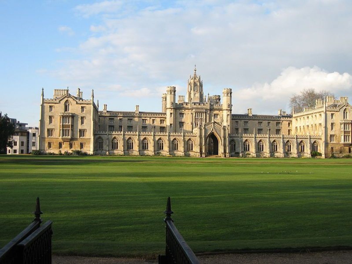
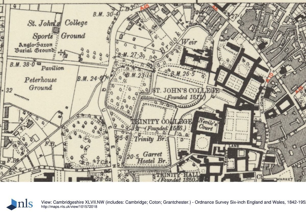
From the Wren Bridge, St John's Meadow to the west is crossed by the Broad Walk, a gravel path with a subsidiary path to the south, flanked by lawns surrounded by a perimeter gravel walk. The curved, tree-lined walk along the south boundary is known as the Bachelors' Walk. This path connects the college via the Wren Bridge with Trinity Paddock immediately to the south via an ornate, single-span cast-iron bridge over the Bin Brook (1874, listed grade II), and with Trinity Pieces to the south-west via a causeway. The meadow is bounded by drains to the west and south and the river to the east, with New Court (T Rickman and H Hutchinson 1826(31, listed grade I) dominating to the north side. This Tudor-gothic composition terminates the northern end of The Backs, consisting of a three-sided grassed court with a single-storey cloister to the south, at the centre of which stands a gateway giving access to the meadow to the south. To the north of New Building stands the Cripps Building (Powell & Moya 1960s), a linear structure broken by various changes of direction running from west to east along the north boundary of the college.
A causeway flanked by drains runs south from the end of the Bachelors' Walk at the south-west corner of the meadow. The causeway runs between the Wilderness to the west and Trinity College's North Paddock to the east, arriving at a wrought-iron gateway (early-mid C18, erected elsewhere 1780, moved to current position 1822, listed grade II*) with flanking iron piers and overthrow, giving onto Trinity Piece to the south.
The Broad Walk continues west beyond the meadow as High Walk, carried over the Bin Brook by the single-span, decorative cast-iron High Walk bridge (1822, listed grade II). High Walk is flanked by a lime avenue, and beyond this the hedged Wilderness to the south and the Scholars' Garden to the north. These gardens are entered off High Walk via four iron pedestrian gates (three modern, one, to the Wilderness, C19, all listed grade II) set into the hedges towards their east and west ends. The walk is terminated at Queens' Road by the Field Gate (1822, to C17 design, listed grade II), set back off the road, with stone piers and eagle finials supporting wrought-iron gates and overthrow with the college arms, and flanked by dwarf walls with railings above.
The layout of the Meadow and High Walk has altered little since the late C17 (Loggan, 1688, 1690), when cattle were grazed on the Meadow and the Broad Walk was lined with an avenue of trees.
GARDENS
The Fellows' Garden or Wilderness lies at the south-west corner of the college, bounded to the west by Queens' Road from which it is divided by a sunk wall with cast-iron railings above (C19, listed grade II). It is bounded to the south and east by drains, and to the north by High Walk. The rectangular area is largely laid to an informal lawn planted with many mature trees and shrubs, underplanted with many bulbs, surrounded by a straight perimeter gravel path, raised in places along the south and east boundaries. In the north-east corner lies a bowling green with a small pavilion at the west side. In the late C17 (Loggan, 1688, 1690) the Fellows' Garden was laid out formally, with the bowling green in its present position, adjacent to two enclosed rectangular areas to the south where the lawn now lies. All three areas were separated by paths, and enclosed by a perimeter path. This is the area which it is believed Lancelot Brown worked on, possibly removing the formal layout in favour of the present informal, landscaped design. By the late C18 (Custance, 1798) the area had lost most of its formality, replaced by a grove of trees, as now remains.
The Scholars' Garden (C20), standing on former orchard grounds, lies adjacent to the north side of High Walk, a rectangular garden bounded by clipped hedges with a perimeter path and, between the two, mixed borders. The area is divided into two, that to the east laid to open lawn, that to the west planted with specimen trees and shrubs.
The Master's Garden lies north of Third Court, adjacent to the river, bounded to the north by the dark red-brick Master's Lodge and adjacent stables (Sir Gilbert Scott 1863, listed grade II) and to the east by the west range of Chapel Court. The Garden is reached from a garden door in the south side of the Lodge, and from a passage through Chapel Court's west range at the north end. The Garden is laid out in several sections, the largest to the south, principally laid to lawn, overlooking the river and River Court beyond, between the back of New Court and the Cripps Building. A large old horse chestnut dominates the lawn, with a mature plane tree by the river. A raised terrace supported by a low, drystone retaining wall runs along the north side of this lawn, connecting it with the south front of the Lodge. A gravel path runs along the top of the terrace, flanked by broad borders, with several sets of stone steps leading down to the lawn. At the west end of the terrace a formal lawn is set with island rose beds, enclosed to the north, east and south by clipped yew hedges. Gravel paths lead south from the terrace's east and west ends, that to the west along the riverside adjacent to a low wall above the river.
REFERENCES
Loggan, Cantabrigia Illustrata (1690)
Beeverell, Les Delices de la Grand Bretagne ... (1707)
R Willis and J W Clark, Architectural History of the University of Cambridge 4, (1886)
Country Life, 68 (18 October 1930), pp 470-7; (25 October 1930), pp 516-23; (15 November 1930), pp 616-23
Architectural Review 50, no 601 (January 1947), pp 13-18
The Eagle 54, (1951), pp 412-19; 56, (1954), pp 1-5
Victoria History of the County of Cambridgeshire III, (1959), pp 437-44
N Pevsner, The Buildings of England: Cambridgeshire (1970), pp 143-58
D Stroud, Capability Brown (1975), pp 171-2
A Crook, From the Foundation to Gilbert Scott (1980), pp 61-6, 72, 86-9
L P Wilkinson, Le Keux's Engravings of Victorian Cambridge (1981)
R Gray, Cambridge Colleges (1984), pp 520-7
M Batey, The Historic Gardens of Oxford and Cambridge (1989), pp 24, 39, 92-3, 99-100, 120-2, 131, 141, 171-2, 178
Maps
Lyne, Map of Cambridge, 1574
Hamond, Map of Cambridge, 1592
Loggan, Map of Cambridge, 1688 (from Cantabrigia Illustrata, 1690)
Custance, Map of Cambridge, 1798
Baker, Map of Cambridge, 1830
Copy of an old plan in Clare College Treasury showing layout of Fellows' and Master's gardens before C17 rebuilding (in Willis and Clark 1886)
OS 25" to 1 mile: 3rd edition published 1925
OS 1:500: 1st edition published 1888
Description written: February 1998
Register Inspector: SR
Edited: January 2001
- Visitor Access, Directions & Contacts
Access contact details
The site is open throughout the year, at weekends only in winter.
Directions
Centre of Cambridge.
- History
The following is from the Register of Parks and Gardens of Special Historic Interest. For the most up-to-date Register entry, please visit the The National Heritage List for England (NHLE):
www.historicengland.org.uk/listing/the-list
HISTORIC DEVELOPMENT
St John's College was founded in 1511 on the site of the suppressed Hospital of St John the Evangelist (established C12) with money left by the Lady Margaret Beaufort, mother of Henry VII, who had also founded Christ's College, Cambridge (qv) in 1505. The college was developed during the C16 and C17, three courts being built axially from east to west, incorporating the old hospital chapel in First Court. In the late C17 Sir Christopher Wren (1632-1723), upon being asked for suggestions about rebuilding the college bridge over the river, suggested moving the site of the bridge further north, so that it would have been on the axis of the three courts. Wren's assistant, Nicholas Hawksmoor produced a plan for the new arrangement in 1698, but this was rejected by the college, who in 1709 began a new bridge on the old site, based upon Wren's early sketches when initially consulted (Crook 1980). In 1772 the Master, William Powell, consulted Lancelot Brown (1716-83); although little detail is known about his influence on the college grounds, in 1778 Brown was presented with a piece of plate valued at £50, indicating some influence. New Court was built in the 1820s on marshy ground to the west of the river, and the chapel was rebuilt in the 1860s, slightly to the north, based on the Sainte Chapelle in Paris. In the late C19 and early to mid C20 two new courts were built north of First and Second Courts. The site remains (1998) in college use.
Period
- Post Medieval (1540 to 1901)
- Tudor (1485-1603)
- Associated People
- Features & Designations
Designations
The National Heritage List for England: Register of Parks and Gardens
- Reference: GD1623
- Grade: II*
Features
- College (featured building)
- Description: St John's College was founded in 1511 by Lady Margaret Beaufort, mother of Henry VII. The second largest of the constituent colleges of the University of Cambridge, it has about 135 fellows, 530 undergraduates and 300 graduate students.
- Earliest Date:
- Latest Date:
- Gate
- Description: Wrought iron gates (which were removed from Horseheath Hall in 1777).
- Croquet Lawn
- Description: The Bowling Green is now a croquet lawn with a small pavilion.
- Wilderness
- Planting
- Description: The Scholars' Garden, laid out to plans by Dame Sylvia Crowe in 1952, with yew hedges enclosing a rectangular garden with a central pavilion.
- Earliest Date:
- Latest Date:
- Riverside Walk
- Planting
- Description: The Master's Garden overlooks the river and is dominated by a large plane tree and a chestnut both planted around 1868.
- Rose Garden
- Description: Overlooking the river is a formal rose garden enclosed by yew hedging.
- Key Information
Type
Garden
Purpose
Ornamental
Principal Building
Education
Period
Post Medieval (1540 to 1901)
Survival
Extant
Hectares
9
Open to the public
Yes
- References
References
- {English Heritage Register of Parks and Gardens of Special Historic Interest} (Swindon: English Heritage 2008) [on CD-ROM] Historic England Register of Parks and Gardens of Special Historic Interest
- Stroud, D {Capability Brown} (1975) p 171-172 Capability Brown
- Pevsner, N {The Buildings of England: Cambridgeshire} (Harmondsworth: Penguin, 1970) pp 143-158 The Buildings of England: Cambridgeshire
- Batey, M., {The Historic Gardens of Oxford and Cambridge} (London: Macmillan London, 1989) The Historic Gardens of Oxford and Cambridge
- Roach, J.P.C. {Victoria County History: Cambridgeshire and the Isle of Ely, Volume 3} (Oxford: Oxford University Press, 1959) 143-58 Victoria County History: Cambridgeshire and the Isle of Ely, Volume 3