Introduction
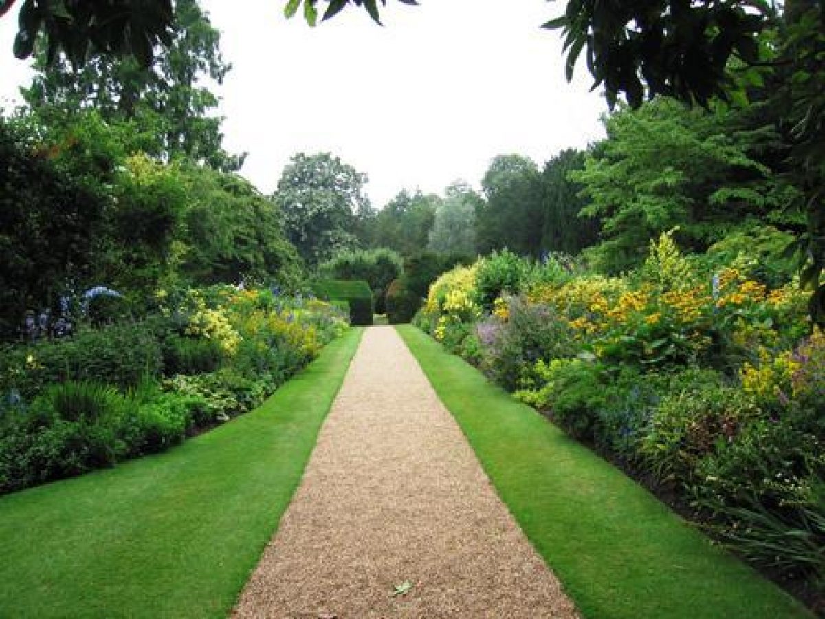
Clare College has enclosed formal gardens 2.5 hectares (6.1 acres)in size associated with Clare College. The layout still reflects the one described in 1688 with an enclosed walk and four lawns crossed by paths. The gardens feature a wide range of traditional planting such as a double sided herbaceous border, clipped yew hedges, terraces and a sunken pond.
Terrain
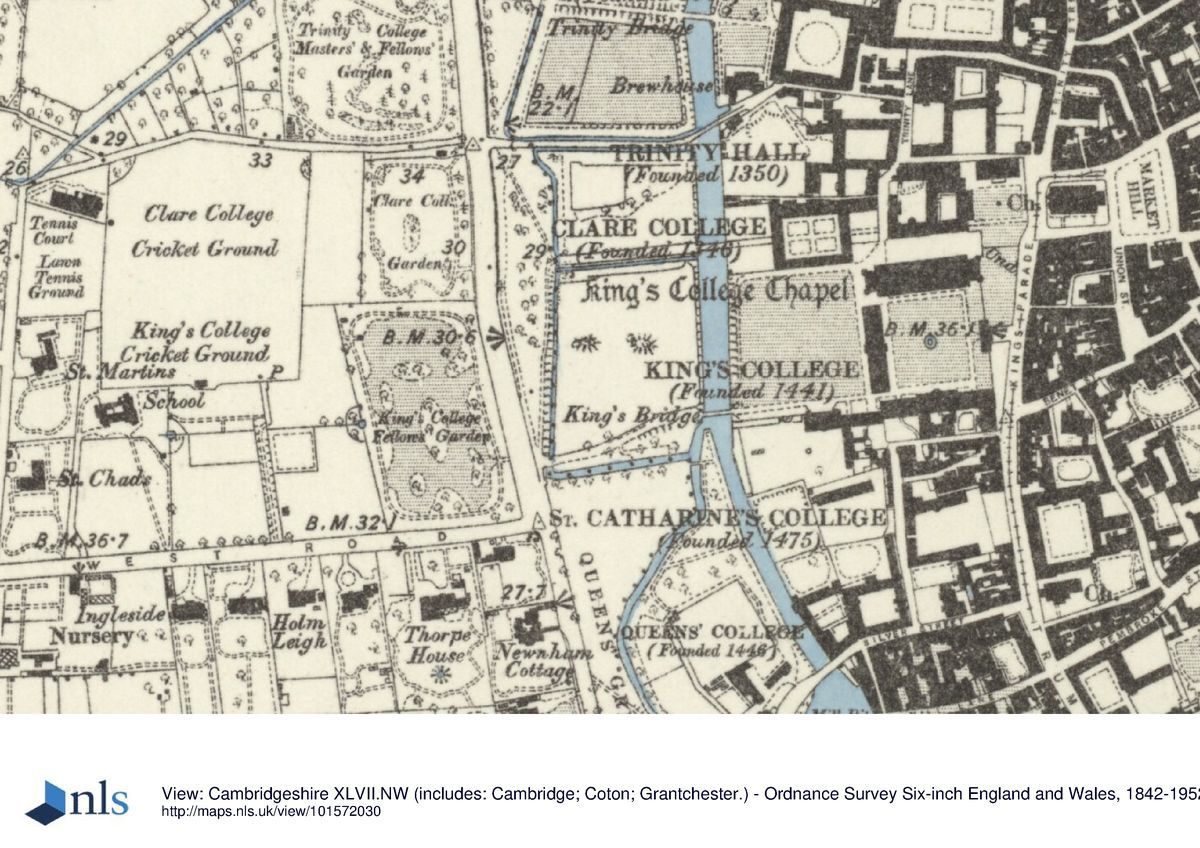
The site is on flat ground surrounded by drainage ditches.The gardens of Clare College consists of two 'courts': Old Court which sits to the east of the Cam, and Memorial Court which is located to the west of Queens Road. The Gardens were substantially re-designed in 1947 by E H Willmer following a period of neglect during the Second World War but many features survived the alterations.
The
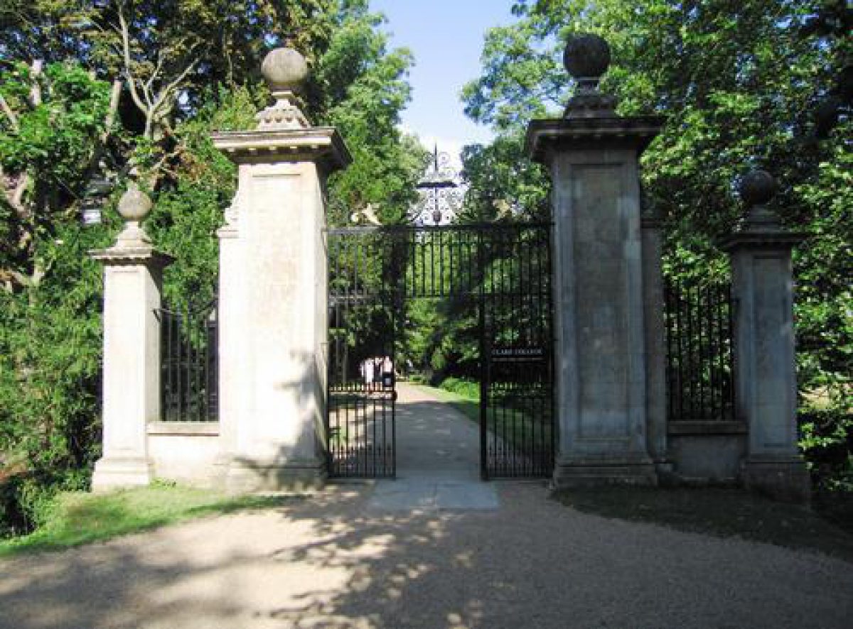
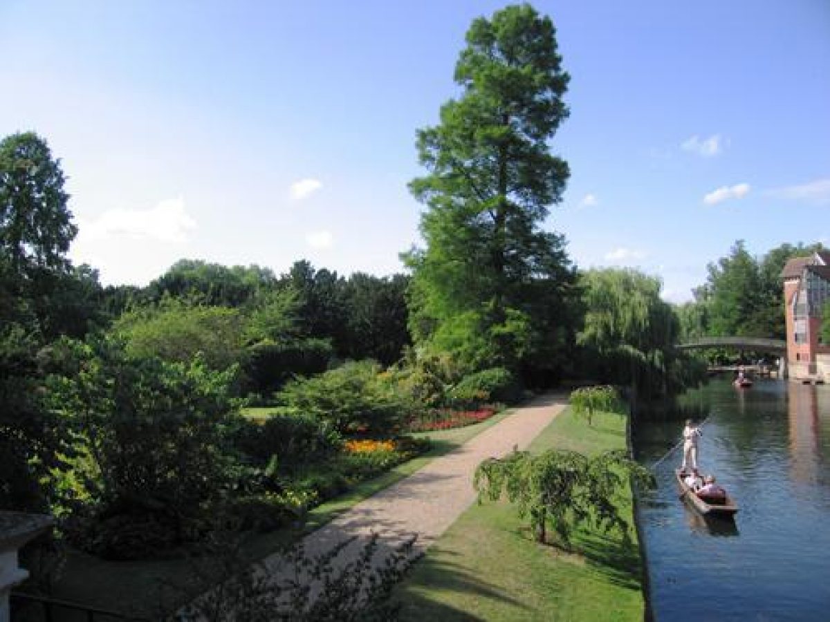
Trinity Lane entrance to Old Court still has the fine iron gates by Warren (1713) and the stone gateposts carved by Pearce in 1675. Thomas Grumbold's balustraded bridge of 1639 over the Cam joining the two areas of garden also remains, being the first in Cambridge to be designed in the Classical style.Old Court still retains its four lawns bisected by paths and has a formal layout including lavender hedges. Spring bulbs and limes form an avenue to the west of the river and the Fellows garden, designed by Willmer, contains a herbaceous border with clipped yews which sweeps diagonally to the river. The river frontage is planted with red flowers and two borders of white and yellow flank the grass path which leads to the sunken water garden. The Memorial Garden to the west of Queen’s Road is noted for its cedar and Wellingtonia and evergreen planting.
The following is from the Register of Parks and Gardens of Special Historic Interest. For the most up-to-date Register entry, please visit the The National Heritage List for England (NHLE):
www.historicengland.org.uk/listing/the-list
College quadrangles and gardens, laid out between the 17th and 20th centuries.
DESCRIPTION
LOCATION, AREA, BOUNDARIES, LANDFORM, SETTING
Clare College lies at the centre of Cambridge, on flat ground surrounded by drainage ditches. The c 3ha college is bounded to the north by Trinity Hall (qv), and, west of the River Cam, Trinity College land (qv), to the east by Trinity Lane and beyond this the old University buildings, and to the south by King's College (qv) which runs parallel to it. Clare College is set within a group of city-centre colleges, cut from north to south by the River Cam and by Queen's Road, the area between river and road forming the centre section of the sequence of five adjacent college gardens and meadows which, taken together, are known as The Backs. In 1779 Lancelot Brown (1716-83) provided a plan to landscape The Backs, including that part of Clare College west of the river. He intended to widen the river into a serpentine lake, and remove the boundaries between individual college grounds together with King's, Clare and Trinity College bridges, using King's College Gibbs' Building as the substitute focal point for a great house. This plan was never carried out and The Backs remain individually owned and designed pleasure grounds and gardens.
ENTRANCES, APPROACHES AND COURTS
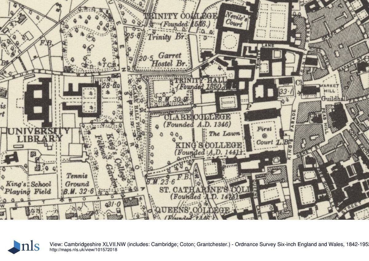
The college is largely laid out around an axial path beginning at Trinity Lane to the east and running for 300m west, through Old Court and across The Backs to Queen's Road. It is approached from the east, off Trinity Lane, through a stone gateway (listed grade I) giving on to a forecourt open to east and south. The rusticated stone gate piers with vase finials (Robert Grumbold 1673) support wrought-iron gates with an elaborate overthrow (1714) and are flanked by railings on a low stone wall fronting the lane and forming the boundary with King's College to the south. King's College chapel adjacent to the south dominates the forecourt, with views south-west between the chapel and the south-east corner of the forecourt, across Back Lawn towards King's Bridge and Scholar's Piece beyond the river. The other two sides of the forecourt are bounded by the college chapel (1760s, listed grade I) to the north, and to the west by the entrance front within the east wing of Old Court. A stone and cobbled path, flanked by low, clipped lavender hedges and two panels of lawn, crosses the forecourt from the Trinity Lane gateway to the iron gated archway into Old Court.
Old Court (1630s-early C18, listed grade I), encloses a rectangular space, divided by two cruciform stone and cobbled paths into quarters laid to lawn. Semicircular steps lead down into the court from the centre of the north and south ranges. The central east/west axial path from Trinity Lane gateway continues through a further gated archway in the centre of the west range, beyond which it is flanked by low brick walls separating it from the lower Master's and Scholars' Gardens to north and south respectively. The path crosses the river, carried by Clare Bridge (Thomas Grumbold 1638-40, listed grade I), a three-arched stone structure in early Renaissance style, with a balustrade surmounted by ball finials. From here views open up to north and south along the river and across to the adjacent Backs and college buildings and gardens, particularly those belonging to King's and Trinity Colleges and Trinity Hall.
The path continues west beyond the bridge, raised on a causeway across The Backs, approached from the west side of the bridge via an elaborate wrought-iron triple gateway with overthrows and flanking railings (1714, listed grade I). The Fellows' Garden lies north of the causeway, at a lower level, entered off the path from several points. To the south the causeway is separated by an open drain from King's College's Scholar's Piece, across which meadow views of King's College buildings and Back Lawn open up. The path terminates at the entrance to the public open space known as Clare Hall Piece (now, 1998, owned by King's College), c 175m west of Old Court. The end of the path is marked by an ashlar gateway (1691) with ball finials, between flanking piers, with a wrought-iron gate with overthrow and railings (c 1714, the whole listed grade II*). This gateway crosses a drain and gives onto Clare Hall Piece, laid to lawn with lines of alders and beeches (mid(late C20) and a path running north/south with views east over Clare, Trinity College and King's College land, including The Backs, towards their college buildings. The western boundary is formed by Queen's Road.
On the west side of Queen's Road stands the three-storey, brick Memorial Court (Sir Giles Gilbert Scott 1922-33, listed grade II*), a nine-sided court set 50m back off the road in its own grounds, erected to commemorate those lost in the First World War. The main, east front is approached from Queen's Road, entering through an iron screen with central gates flanked by brick piers with heavy sculpted finials (c 1930, probably Scott, listed grade II). A gravel drive, flanked by lawns edged with mature shrubberies, runs west to a set of broad stone steps leading up to the central archway in the east side of the court, entered through a stone gateway supporting bronze gates. The entrance, aligned with the dominant University Library tower to the west, opens onto the Court within, originally a formal open space with straight paths and rectangular lawns but now containing a late C20 library building at the centre, with the remains of the earlier layout to west and east. The west boundary is defined by a white-painted iron screen and gates (c 1930, probably Scott, listed grade II).
GARDENS
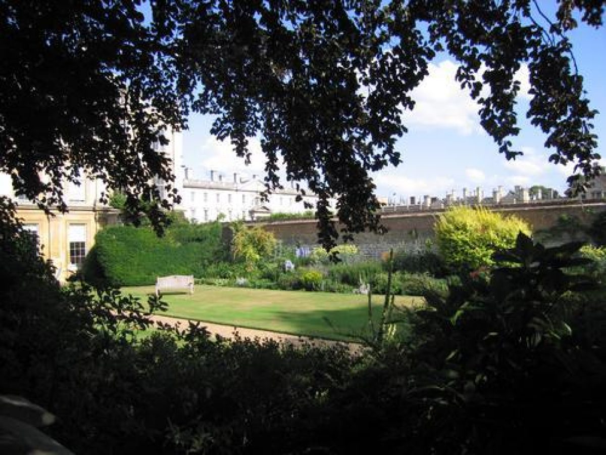
Of the three rectangular college gardens, the two smaller ones lie adjacent to the west range of Old Court, bounded to the west by the river, to the north by Trinity Hall wall and to the south by King's College wall, and divided from west to east by the central college path. The Master's Garden lies to the north of the path, laid largely to lawn surrounded by borders. A central garden door gives onto a small double stone staircase down to a path running west across the centre of the garden. The path terminates at a stone path along the west boundary adjacent to the brick retaining wall, which is lowered, with railings on top, in order to give views across the river to the Fellows' Garden. The path adjacent to this wall rises up a set of stone steps at its south end to an iron gate giving access to the central college path.
The slightly smaller Scholars' Garden lies to the south of the central college path, opposite the Master's Garden. It is also laid largely to lawn with perimeter borders and a central gravel path, and at the west end a raised gravel terrace overlooking the west wall with views west across the river to Scholars' Piece and the Fellows' Garden. It is entered from an iron gate at its north-west corner, off the college path, opposite the entrance to the Master's Garden. Both iron gates are in similar style, with overthrows supporting lamp cages and flanking railings (C18, listed grade II).
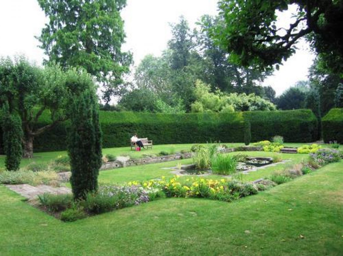
The Fellows' Garden lies west of the river, bounded by ditches edged by a line of yew trees to the north and west, the river to the east, and the adjacent raised causeway and college path to the south. It is said to have been laid out in its present form in 1946(7 by Walter Barlow, the head gardener (CL 1971), to designs by Professor Willmer. The rectangular area is entered from the west side of Clare Bridge through an iron gate attached to the triple gateway onto the causeway, down a set of stone steps to a straight gravel path set in lawn along the raised river bank with views east over the river into the Master's Garden and towards Trinity Hall and College and King's College. The southern half of the garden is laid to informal lawn with serpentine perimeter borders. The northern half is divided into three main sections. The west section is used as a nursery; the central section, a water garden, contains a formal rectangular sunken pool edged with stone, surrounded by a sunken lawn and low stone retaining walls, the whole surrounded by an upper lawn and a clipped yew hedge, except on the north side which is bounded by a wall with a central gateway; the east section, entered from the water garden through a gap in the hedge, contains a central gravel path running east, flanked by herbaceous borders. The brick wall continues east along the north side, with a shrub bed to the south. The gravel path joins the riverside path at its north end. These three sections are linked to the north by a path running between the wall and the line of boundary yews to the north. A set of semicircular steps from the main lawn leads back up the causeway to the college path.
In the late C17 (Loggan, 1688, 1690) the layout east of Queen's Road appears to have been similar to now (1998), differing only in the internal details of some of the compartments. The Fellows' Garden was an open meadow, Clare Hall Meadow, surrounded by rows of trees. The Master's Garden was laid out informally, with trees and a path running diagonally from south-east to north-west across it, and the Scholars' Garden was called the Bowling Green. An avenue of trees ran along the college path from Old Court to Clare Hall Green (Piece as it is now known). By the mid C18 (Cantabrigia Depicta 1763) the Master's Garden was laid out with two rectangular lawns separated by a broad axial path running from west to east as now, and surrounded by a broad path. The Scholars' Garden had a central lawn and broad perimeter path. The walls bounding the main college path between these two gardens were in place, together with the two iron gateways and railings at the west end by Clare Bridge. By the late C19 (OS) both these gardens had been informalised and given serpentine perimeter paths and central lawns with perimeter borders, and the west boundary terrace in the Scholars' Garden was present. By this time the Fellows' Garden had gained essentially the same structure as now, without the formal water garden, although its enclosure had been formed, but with the straight perimeter paths to west, north and east, and the main informal lawn in the south section.
REFERENCES
Loggan, Cantabrigia Illustrata (1690)
Beeverell, Les Delices de la Grand Bretagne ... (1707)
Cantabrigia Depicta (1763), pp 28-9
R Willis and J W Clark, The Architectural History of the University of Cambridge 4, (1886)
Country Life, 60 (3 July 1926), pp 18-26; (10 July 1926), pp 58-65; 121 (14 March 1957), p 468; 150 (2 September 1971), pp 552-3
Architectural Review 50, no 601 (January 1947), pp 13-18
Victoria History of the County of Cambridgeshire III, (1959), pp 340-5
N Pevsner, The Buildings of England: Cambridgeshire (1970), pp 56-62
L P Wilkinson, Le Keux's Engravings of Victorian Cambridge (1981) pp 42-3
R Gray, Cambridge Colleges (1984), pp 16-19
M Batey, The Historic Gardens of Oxford and Cambridge (1989), pp 70, 82, 94, 100, 106-7, 109, 121-2, 160, 165
Maps
Lyne, Map of Cambridge, 1574
Hamond, Map of Cambridge, 1592
Loggan, Map of Cambridge, 1688 (from Cantabrigia Illustrata, 1690)
Custance, Map of Cambridge, 1798
Baker, Map of Cambridge, 1830
Copy of an old plan in Clare College Treasury showing layout of Fellows' and Master's gardens before C17 rebuilding (in Willis and Clark 1886)
OS 25" to 1 mile: 3rd edition published 1925
OS 1:500: 1st edition published 1888
Description written: February 1998 Amended: February 1999
Register Inspector: SR
Edited: January 2001
- Visitor Access, Directions & Contacts
Access contact details
01223 333200 http://www.clare.cam.ac.uk/Visiting-Clare-College/
- History
The following is from the Register of Parks and Gardens of Special Historic Interest. For the most up-to-date Register entry, please visit the The National Heritage List for England (NHLE):
www.historicengland.org.uk/listing/the-list
HISTORIC DEVELOPMENT
Lady Elizabeth de Clare refounded Richard de Badew's University Hall as Clare College in 1338, but nothing remains of the medieval buildings. The college was rebuilt, starting in 1638 and continuing until 1719, creating a single rectangular court, Old Court, with designs influenced by Sir Christopher Wren. Clare Bridge was built over the River Cam between 1638 and 1640, giving access to the gardens on The Backs, the first bridge at Cambridge in Classical style, and the oldest surviving bridge in the city. Loggan (1688, 1690) shows two open rectangular gardens west of the river, reached across the bridge, from which the raised axial path extends west towards Queen's Road, with informal, rectangular gardens to north and south. The area covered by the southern garden, labelled King's College's Meadow, does not seem to have been part of Clare gardens. Between 1922 and 1933 Sir Giles Gilbert Scott's Memorial Court was erected, the first major college building erected west of Queen's Road and The Backs. The site remains (1998) in college use.
- Associated People
- Features & Designations
Designations
The National Heritage List for England: Register of Parks and Gardens
- Reference: GD1608
- Grade: II
Style
Formal
Features
- Terrace
- Pond
- Description: Sunken pond and water garden
- Hedge
- Description: clipped yew and lavendar hedges
- Herbaceous Border
- Shrub Border
- Ironwork
- Description: Iron gates by Warren
- Earliest Date:
- Latest Date:
- Gate
- Description: Carved gate piers by Robert Grumbold, carved by Pearce
- Earliest Date:
- Latest Date:
- College (featured building)
- Description: The college was rebuilt, starting in 1638 and continuing until 1719, creating a single rectangular court, Old Court, with designs influenced by Sir Christopher Wren.
- Earliest Date:
- Latest Date:
- Ornamental Bridge
- Description: Clare Bridge
- Key Information
Type
Garden
Purpose
Ornamental
Principal Building
Education
Survival
Extant
Hectares
2.5
Open to the public
Yes
- References
References
- Cambridgeshire Gardens Trust {The Gardens of Cambridgeshire} The Gardens of Cambridgeshire
- {English Heritage Register of Parks and Gardens of Special Historic Interest} (Swindon: English Heritage 2008) [on CD-Rom] Historic England Register of Parks and Gardens of Special Historic Interest
- Pevsner, N {The Buildings of England: Cambridgeshire} (Harmondsworth: Penguin, 1970) pp 59 - 62 The Buildings of England: Cambridgeshire
Contributors
Cambridgeshire Gardens Trust
- Related Documents
-
CLS 1/365
Draft Master Plan Report, Landscape History, Figs. Only - Digital copy
Elizabeth Banks Associates - 2002
-
CLS 1/365