
Introduction
Tottenham Park has parkland landscaped in the 18th century, with lengthy forest avenues and rides.
The following is from the Register of Parks and Gardens of Special Historic Interest. For the most up-to-date Register entry, please visit the The National Heritage List for England (NHLE):
www.historicengland.org.uk/listing/the-list
C18 and C19 pleasure grounds set within a park laid out in the late C17 and C18 and a forest dating back to the medieval period, with formal avenues and woodland rides, including work by Richard Boyle (Lord Burlington) of c 1721 and Lancelot Brown from 1764 to c 1770.
Location, Area, Boundaries, Landform and Setting
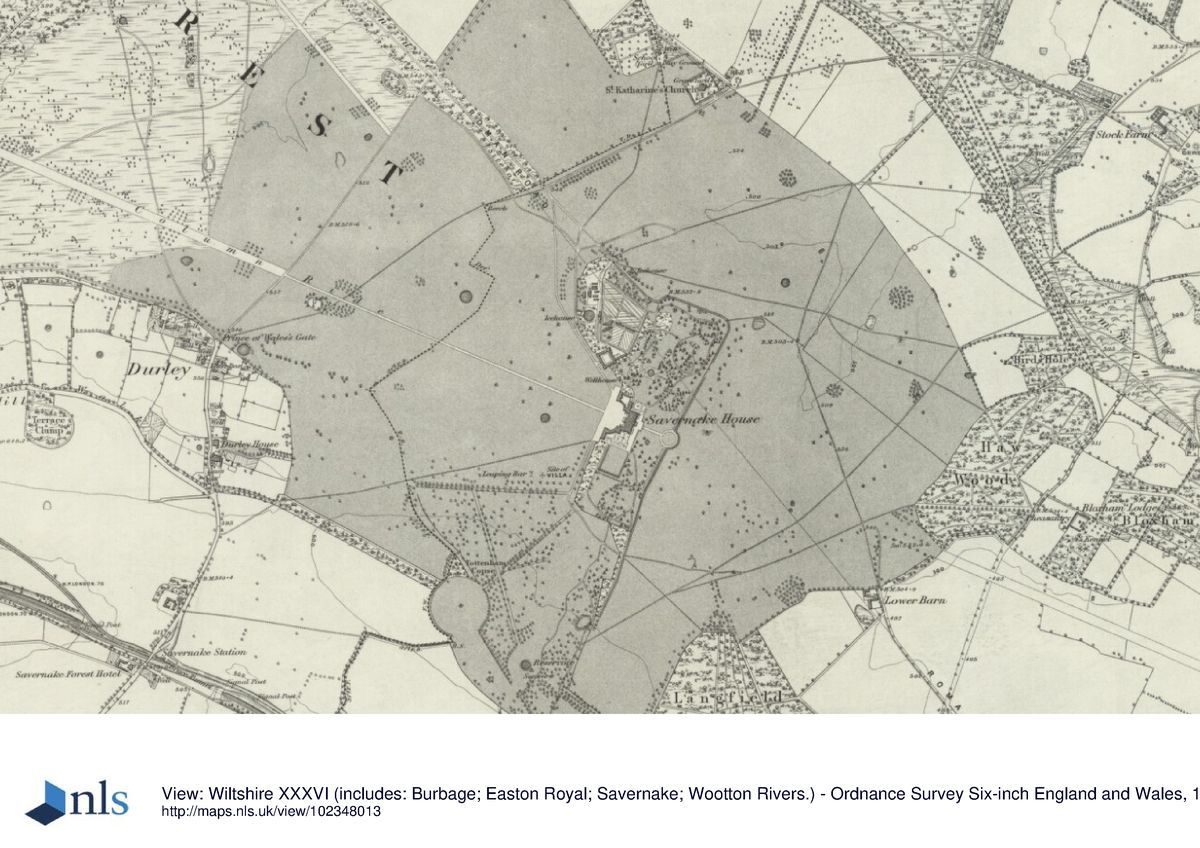
Tottenham Park and Savernake Forest lie immediately to the south-east of Marlborough. To the west lies the A346, which runs south from Marlborough, and to the north the A4, London Road, which runs east from Marlborough. To the south lie the Kennet and Avon Canal and the railway between Frome and Great Bedwyn. To the north-east the site is bounded by farmland and to the south-east by Bedwyn Common and Stock Common. The site of c 1600ha comprises of walled and ornamental gardens, parkland, and woodland.
Entrances and Approaches
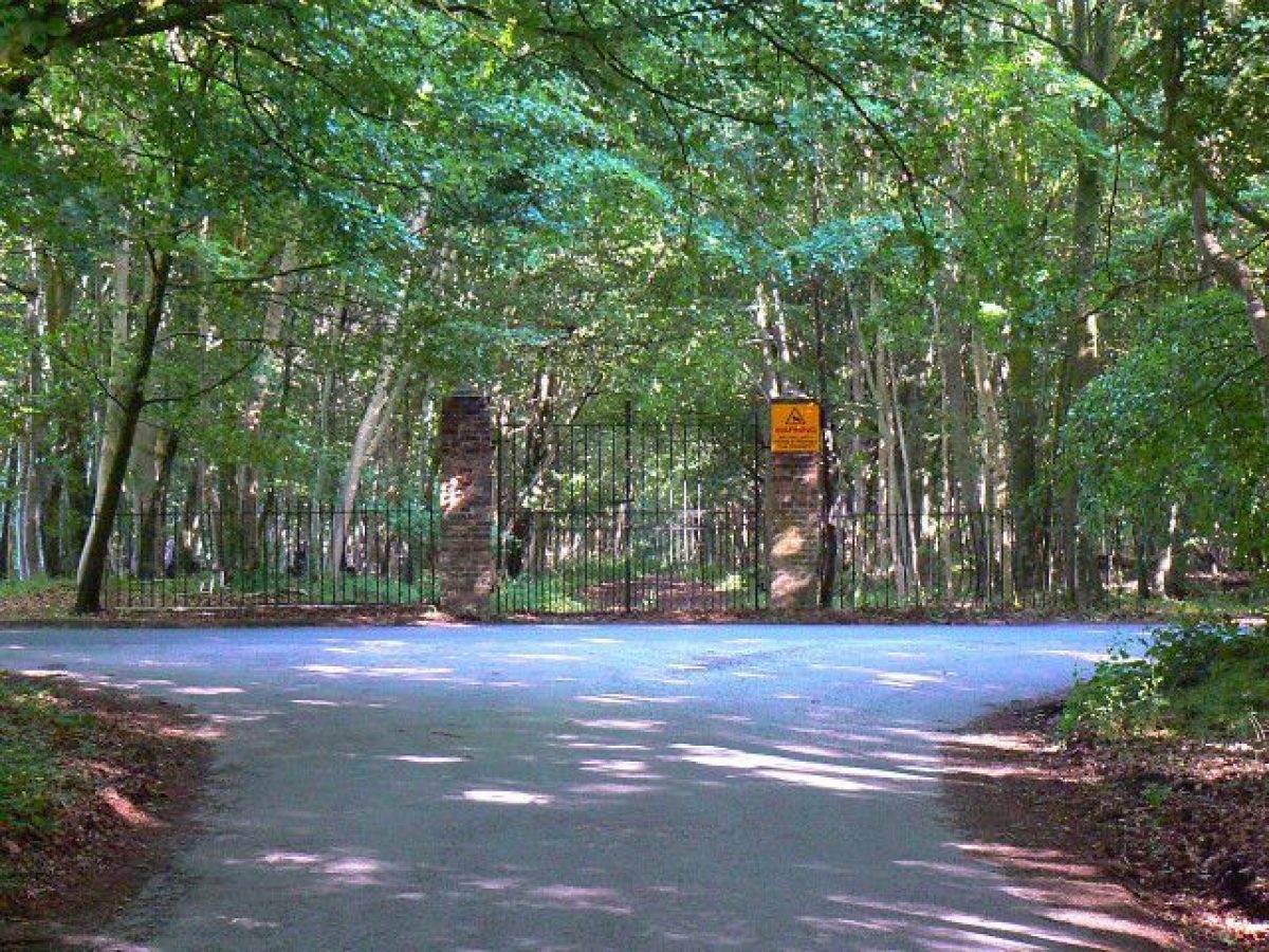
The main approach to Tottenham House is from the north via the Grand Avenue. At its north end, along the A4 (London Road), the entrance is marked by two gate piers (listed grade II). From here the Grand Avenue runs for c 5.5km through the full length of Savernake Forest in a south-easterly direction, towards the kitchen garden and stable block north-west of the mansion. At Laidens Lye, a clearing in the centre of the Forest, is the Eight Walks, a circular junction where the Grand Avenue meets with the Twelve O'Clock Drive, Great Lodge Drive, Sawpit Drive, and three other approaches which radiate from the central point to north/south, east/west, and south-west/north-east respectively through the Forest (Estate plan, 1786).
Principal Building
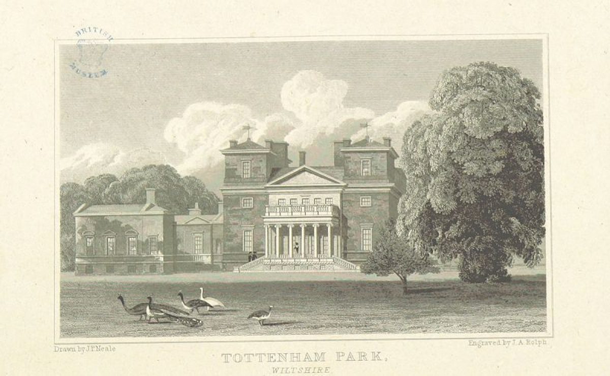
Tottenham House (c 1820, listed grade I), designed by Thomas Cundy, stands towards the south-east end of the site. The two-storey mansion is built of ashlar limestone and has a slate roof. It has a main central block of seventeen bays, which is connected by quadrant wings to outer pavilions. Attached to the rear of the southern quadrant wing is a conservatory of c 1828, with a barrel-vaulted roof supported by cast-iron columns, manufactured by Richards and Jones of Birmingham. A second conservatory attached to the north-east end of the house was added in the late C19.
The stable block (listed grade II*), also by Thomas Cundy but completed in 1818 before the mansion was built, is situated c 150m to the north-west of the House. The two-storey rectangular building has a central open courtyard and is built of ashlar limestone with a slate roof. On its west side is an arched central entrance with a clock tower and a belfry with a dome built over it. The stable block is built on the site of a former greenhouse or orangery (Estate plan, 1786) which was demolished between c 1820 and 1879 (Parklands Consortium 2000).
Gardens and Pleasure Grounds
The pleasure grounds are situated to the south-west, north-east, and south-east of the mansion. They are separated from the park to the north and east by a late C18 ha-ha introduced by Lancelot Brown and built partly of bricks from an earlier kitchen garden (ibid).
The layout of the pleasure ground to the north-east is dominated by the London Walk (Estate plan, 1730-40; Rysbrack painting, after 1737), which runs north-east from the mansion. It continues into the park and leads through Bedwyn Common (Estate plan, 1786). A C20 square pond situated c 100m north-east of the mansion is on the site of an early C19 circular pond and prior to that, an early C18 rectangular canal (Estate plan, c 1730¿40). Both sides of the ride are lined by densely planted mature trees and shrubs through which runs a serpentine walk laid out by Lancelot Brown in the late C18 (Colvin and Moggridge 1993), now (2002) much overgrown. Brown's walk is linked to a network of secondary paths dating from the late C19.
To the east-south-east of the House lies the Exedra Lawn or East Bastion, laid out by Burlington in the early C18 (Rysbrack painting, after 1737; Estate plan, c 1730-40). During this period a kitchen garden was situated immediately to the south-east of this area which was demolished by 1786 (Estate plan). Adjacent, along the north side of the Exedra Lawn, is a rectangular swimming pool, introduced in the late C20. The Exedra Lawn contains a circular walk and its south-east end is closed off by a decorative stone balustrade. Formerly, as shown on Rysbrack's painting, the Lawn was lined on either side with statues on pedestals. From the Lawn, as recorded on an estate map of c 1800, there is a fine view of the park to the south-east and the hills in the far distance.
The terrace immediately south of the mansion, in front of the conservatory and orangery, is laid out as a formal garden with a central fountain. Along the south side is a stone balustrade separating the garden from a sunken lawn situated below it. Rysbrack's painting suggests this sunken area may have been a pond. The formal garden dates from the late C19 and replaced a Flower Garden and American Border, laid out shortly after Thomas Cundy's rebuilding of the mansion in c 1820 (Gardener's Mag 1831). Formerly this area formed part of the Great Walk, laid out by 1716 (Price Survey). This Walk, now (2002) only partly visible, leads to a reservoir c 700m south-south-west of the mansion. The reservoir occupies the site of Burlington's former Banqueting Hall, demolished by the late C19 (OS 1888).
South-east of the reservoir is a strip of woodland that follows the line of the former Tottenham Ridge Avenue or Truffle Walk, which led to Langfield Coppice or Lime Kiln Wood situated to its south-east. Along the east side of the Great Walk is a plantation on the site of the former Wilderness, with beyond it a pasture, the former Lady Lawn. West of the Great Walk lies Tottenham Copse or Durley Wood, through which leads the now (2002) only partly visible Octagonal Pavilion Ride. This ride ran for a distance of c 350m north-east from the circular lawn surrounding the Octagon (listed grade II*), an early C18 summerhouse designed by Burlington situated c 700m south-west of the mansion. The circular lawn is bounded to its west by a late C18 ha-ha.
The northern boundary of Tottenham Coppice is lined by the remains of King Harry's Walk, a walk of c 500m which led west from a point c 150m south of the mansion to King Harry's Summer House. This building was demolished by the late C19 (OS 1888). There are remains of two further rides: the Western Ride, which ran between the Octagon and King Harry's Summer House, and the Banqueting Hall Ride, which ran from the Banqueting House in a north-westerly direction through Tottenham Coppice and then linked up with King Harry's Walk.
These walks, rides, and features formed part of the early C18 formal landscape designed by Burlington and are partly shown on the estate plan of c 1730-40 and on Rysbrack's painting dated after 1737. The layout of this area remained largely unchanged during the C19 and C20, as shown on the 1st and 2nd edition OS maps and a series of aerial photographs taken in 1944. After the Second World War this area, including Tottenham Copse and part of Langfield Copse, was used as a deer park (Colvin and Moggridge 1993).
Park
The park has two main parts: Tottenham Park in the south-eastern section of the site, and Savernake Forest, the forest park to the north-west. Both are linked by a series of formal rides.
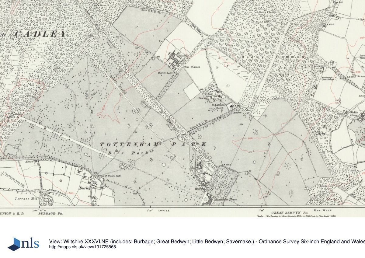
Tottenham Park extends to the north, south, and east of the mansion. Clumps of trees of various sizes are scattered across it. The park to the south-east of the mansion is bounded by the woodland plantations of How Wood and Birds Hole. From Birds Hole a ride, in some places overgrown (2002), runs in a north-westerly direction through a narrow woodland belt, across Stock Common and Bedwyn Common, into Savernake Forest (Estate plan, 1786). In Tottenham Park stands St Katherine's church (listed grade II*), c 1km north of the mansion. This was completed in 1861 to designs by T H Wyatt for the second Marquess of Ailesbury and occupies the site of a former nursery. Warren Farm (listed grade II), built in the mid C19 on The Warren Grounds (Estate plan, 1786), is situated c 1.5km north-north-west of the mansion.
The park to the north-west of the mansion is characterised by two early C18 ornamental rides, both lined by a series of platoons, that run from the mansion into Savernake Forest (Estate plan, c 1730-40; Rysbrack painting, after 1737). One is the c 2.2km long Column Ride, named after the Ailesbury Column (listed grade II) which stands at its junction with Three Oak Hill Drive. The latter runs from the A346 at Leigh Hill to the south-west to the Grand Avenue. The Ailesbury Column is enclosed on three sides by marker bollards (listed grade II). The column was erected by Lord Bruce in 1789 following a visit from King George III, and is dedicated to him and Lord Bruce's uncle, Charles, Earl of Ailesbury and Elgin. The Column Ride continues beyond Three Oak Hill Drive for a further c 1.5km and leads to the A346 on the west side of the Forest. This part of the ride is an extension dating from the early C19 (Greenwood, 1820). The other ride in this part of the park is Saddle Ride, which runs from a point c 1km north-west of the mansion for c 2km in a north-westerly direction on a parallel but slightly converging course with the Grand Avenue. It terminates at a monument in the forest.
Savernake Forest occupies the area north of Three Oak Hill Drive. It is characterised by dense woodland mixed with open pastures and lawns scattered with ornamental tree clumps, which are intersected by a complex network of ornamental rides and avenues, both formal and informal in design (aerial photographs, 1944). Lye Hill or Leigh Hill is an area of pasture in the south-west part of the Forest which has a series of mature tree clumps, surrounded by mid to late C20 individual tree planting. Leigh Hill is enclosed by a double avenue, which links up with the Column Ride and Three Oak Hill Drive. South-east of the Eight Walks in the centre of the Forest lies Bagden Lawn (Estate plan, 1786).
Along the north boundary of this irregular lawn stands Savernake Lodge (listed grade II), a late C18 stable block which has now been converted to a house. It was once part of Bagden Lodge, which was enlarged in 1795 by Sir John Soane (1753-1837) for Lord Bruce and was destroyed by fire in 1861. North of Bagden Lawn lies Ashlade, a former lawn planted with trees since the early to mid C20. In the north-west part of the Forest lies Thornhill Nursery, introduced in the late C20. The remains of a medieval park pale enclose the Eight Walks and an area of c 200ha around it. The course of a Roman Road, visible from the air under certain ground conditions, runs from north-west to south-east through the length of the park and the Forest.
Kitchen Garden
The walled kitchen garden lies to the rear of the stable block, c 150m to the north of the House. The trapezium-shaped garden of c 2ha is divided into two compartments by an internal wall. The latter is lined on both sides with outbuildings, sheds, and the footings of former greenhouses. To the west of the kitchen garden is a group of outbuildings and former gardeners' houses, and also the remains of a circular fishpond. Abutting the kitchen garden to the north-east is the site of a late C18 menagerie, previously an orchard (Estate plans, 1786, c 1800).
The kitchen garden dates from the late C18 (Estate plan, 1786) and was designed by Lancelot Brown (Parklands Consortium 2000). It replaced the earlier kitchen gardens situated to the south-east of the mansion (Rysbrack painting, after 1737; Estate plan, c 1730-40).
REFERENCES
J P Neale, Views of the Seats - 5, (1822)
Gardener's Magazine 7, (1831), pp 136-9; 10, (1834), pp 413-19
The Florist, (September 1854), p 273
The Scottish Gardener 3, (1854), pp 311-13
Marquess of Ailesbury, A History of Savernake Forest (1962)
Country Life, no 22 (28 May 1987), pp 132-3
N Pevsner and B Cherry, The Buildings of England: Wiltshire (2nd edn 1975), pp 527-9
D Stroud, Capability Brown (2nd edn 1975), pp 92-5
T Hinde, Capability Brown (1986), pp 107-12
In Search of English Gardens: The Travels of J C Loudon and his wife Jane (National Trust Classics 1990), pp 137-9
Tottenham Park, Pleasury and Deer Park, History and Planning Restoration Strategy, (Colvin and Moggridge 1993)
John Harris, The Artist and the Country House (1995)
Victoria History of the County of Wiltshire XVI, (1999)
Tottenham Park, Great Bedwyn, Wiltshire, Historic Landscape Survey, (Parklands Consortium 2000)
Maps
Map of Savernake Park and Forest showing the perambulation of 1301, late C16 to early C17 (Wiltshire and Swindon Record Office)
C Price, An Accurate Survey of Savernake Great Park, 1716 (Wiltshire and Swindon Record Office)
C Price, An Accurate Survey of Tottenham Park for the Hon Charles, Ld Bruce, 1718 (Wiltshire and Swindon Record Office)
Plan of Totenham Park in the County of Wilts, c 1730-40 (Wiltshire and Swindon Record Office)
Andrews and Drury, Map of Wiltshire, 1773 (Wiltshire and Swindon Record Office)
A Plan of the Forest of Savernake and of Tottenham Park in the County of Wiltshire, 1786 (Wiltshire and Swindon Record Office)
Plan of Tottenham Park and Savernake Forest, c 1800 (private collection)
Survey of the pleasure grounds at Tottenham Park, after 1818 (private collection)
T J Turnbull, Survey of the pleasure grounds at Tottenham Park, c 1820-5 (Wiltshire and Swindon Record Office)
C Greenwood, Map of Wiltshire, 1820 (Wiltshire and Swindon Record Office)
Survey of Tottenham Park, c 1843-5 (Wiltshire and Swindon Record Office)
OS 6" to 1 mile: 1st edition published 1884/6
OS 25" to 1 mile:
2nd edition published 1901
3rd edition published 1926
Illustrations
P A Rysbrack, Bird's-eye view of Tottenham House, after 1737 (private collection) [in Harris 1979]
P A Rysbrack, View of the garden front of Tottenham House from the Exedra lawn, c 1750 (private collection) [in Harris 1979]
Archival items
Sketch, annotated on the reverse: 'Sketch by Mr Hoare of what He understood to be Mr Brown's idea for improvements in the Forest so as to make it one great whole', c 1763 (1300/1933), (Wiltshire and Swindon Record Office)
Designs for gates in Tottenham Park, nd (9/35/60), (Wiltshire and Swindon Record Office)
Architectural drawing of the Banqueting House designed by Lord Burlington, before 1730 (1300/361), (Wiltshire and Swindon Record Office)
Aerial photographs of Tottenham Park and Savernake Forest, 8 March 1944 (US/7PH/GP/Loc209), (NMR, Swindon)
Description written: July 2002 Amended: August 2002
Register Inspector: FDM
Edited: April 2005
- Visitor Access, Directions & Contacts
- History
The following is from the Register of Parks and Gardens of Special Historic Interest. For the most up-to-date Register entry, please visit the The National Heritage List for England (NHLE):
www.historicengland.org.uk/listing/the-list
HISTORIC DEVELOPMENT
By c 1200 the area around Tottenham House, then known as Tottenham Wood, formed part of a large forest known as Savernacke Forest, which covered an area of c 100 square miles (259 square km). In 1330 this forest underwent major disafforestation, except for a few areas which were subsequently formed into separate bailiwicks. Tottenham Wood was situated in the La Verme bailiwick, which initially belonged to the Esturmy family but was taken over during the C15 by the Seymour family. By c 1600 the bailiwicks of the old Savernacke Forest had almost completely disappeared and a series of large parks had been created.
By the late C16 the Seymours had created a deer park at Tottenham, situated around an Elizabethan mansion called Totnam Lodge built c 1575. In 1671, John, Duke of Somerset inherited the Tottenham estate. A year later he improved Totnam Lodge and its park, which by that date included long tree-lined walks and a deer chase (Marquess of Ailesbury 1962). In 1675, after the death of the Duke of Somerset, his estate passed to his granddaughter Lady Elizabeth Seymour, who in 1676 married Thomas, Lord Bruce, Earl of Ailesbury. By that time Totnam Lodge had been destroyed, possibly by a fire (ibid). Subsequently, large areas of the park were converted into agricultural land, which Lord Bruce hoped to return to parkland once his financial situation had improved. In 1696 however, during the reign of William of Orange, he was imprisoned on a charge of treason. He was released shortly after in 1697 but lost his title and was never able to return to Tottenham, which subsequently fell into further decay.
In 1703, Lord Bruce's son, Charles Bruce inherited the Tottenham estate. By 1718 Tottenham House contained gardens, a nursery, a bowling green, and a series of formal rides or avenues, including the Great Walk (Estate plan, 1718). In c 1721 Charles Bruce commissioned his brother-in-law Richard Boyle, Lord Burlington (owner of Chiswick House, qv) to improve the estate. Burlington designed a new house, set within formal pleasure grounds surrounded by a park with avenues, rides, and various garden buildings (Rysbrack painting, after 1737). After Charles Bruce's death in 1747, his son Thomas Brudenell-Bruce inherited the estate. The latter commissioned Lancelot Brown (1716-83), who between 1764 and c 1770 improved the park, Savernake Forest, the pleasure grounds, and built a new kitchen garden (Estate plans, 1786, c 1800; sketch by Hoare, c 1763). In 1776 Thomas Brudenell-Bruce regained the Ailesbury title under King George III.
In 1814, after Thomas Brudenell-Bruce's death, his son Charles, the first Marquess of Ailesbury, inherited the estate. Two years later a new stable block was built, designed by Thomas Cundy who later (c 1820) replaced Burlington's mansion with a new house. The latter included a conservatory and orangery, in front of which a flower garden was created in c 1830, possibly by Henry Burn, head gardener at Tottenham House from c 1815 (Gardener's Mag 1831). During the late C19 and C20 the layout of Tottenham House and Savernake Forest remained largely unchanged. In 1939 the management of the Forest was handed over to the Forestry Commission, who immediately started a tree-planting programme and created a new deer park. During the Second World War a Ploughing-up Order was issued for some parts of the park. The House is currently (2002) in use by the Prince of Wales' Trust. The site has remained in private ownership, and there are plans to develop it for hotel and leisure use including a golf course.
Period
18th Century (1701 to 1800)
- Associated People
- Features & Designations
Designations
The National Heritage List for England: Register of Parks and Gardens
- Reference: GD1443
- Grade: II*
Features
- Avenue
- Mansion House (featured building)
- Earliest Date:
- Latest Date:
- Parkland
- Trees
- Key Information
Type
Park
Purpose
Ornamental
Principal Building
Domestic / Residential
Period
18th Century (1701 to 1800)
Survival
Extant
Hectares
1600
Open to the public
Yes
Civil Parish
Great Bedwyn
- References
References
- {English Heritage Register of Parks and Gardens of Special Historic Interest}, (Swindon: English Heritage, 2008) [on CD-ROM] Historic England Register of Parks and Gardens of Special Historic Interest
- Stroud, Dorothy, {Capability Brown} (London: Faber, 1975), pp. 92-5 Capability Brown
- Pevsner, N. and B. Cherry, {The Buildings of England: Wiltshire} (Harmondsworth: Penguin, 1975), pp. 527-9 The Buildings of England: Wiltshire
- Harris, J., {The Artist and the Country House} {London: Russell Chambers, 1979) The Artist and the Country House
- Hinde, T., {Capability Brown: the story of a master gardener} (London: Hutchinson, 1986), pp. 107-12 Capability Brown: the story of a master gardener
- Pugh. R.B. and E. Crittall (eds), {Victoria County History: Wiltshire, Volume 16} (London: Oxford University Press, 1999) Victoria County History: Wiltshire, Volume 16
- Colvin and Moggridge {Tottenham House Park Historical survey and planting restoration strategy} Tottenham House Park Historical survey and planting restoration strategy
- Related Documents
-
CLS 1/98/388
Historic Landscape Survey - Hard copy
Parklands Consortium - 2004
-
CLS 1/98/388