Introduction
Littlecote Manor has 20th-century gardens of two hectares surrounded by 17th- and 18th-century walls. The gardens are set within a park and agricultural land of 179 hectares. The house is now a hotel.
Terrain
The ground slopes down from south to north towards the course of the River Kennet.
The following is from the Register of Parks and Gardens of Special Historic Interest. For the most up-to-date Register entry, please visit the The National Heritage List for England (NHLE):
www.historicengland.org.uk/lis...
A series of walled gardens and a deer park originating from the late 17th and 18th centuries.
Location, Area, Boundaries, Landform and Setting
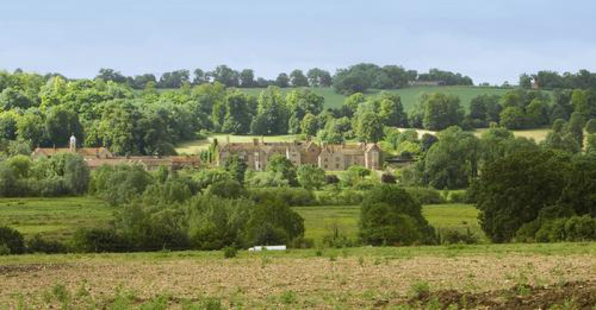
Littlecote House is situated on the south bank of the River Kennet, in the parishes of Ramsbury and Chilton Foliat. The site of c 179ha lies c 2.5km north of Froxfield, which is situated along the A4 road between Marlborough and Hungerford. The ground slopes down from south to north towards the course of the River Kennet, a branch of which runs through the site. To the north the site is bounded by a wetland crossed by various drains which lead from the River Kennet. Along the western boundary of the site lie Whitehill Coppice and Great Coppice. To the south the site is bounded principally by extensive farmland, while to the south-east the line of the former south drive through Cake Wood is marked by a track.
Entrances and Approaches
The site can be entered from the east and west corners, and formerly also from the south. At the entrance in the north-west corner of the site, the late C18 West Lodge (listed grade II) marks the entrance to a public bridleway that runs through the park in a south-easterly direction. After passing the front of the House, the bridleway continues in north-easterly direction as a tarmacked drive and leads to East Lodge (first shown on OS map of 1878), and adjacent gate piers in the far east corner of the site. This bridleway or drive probably follows the course of one of the former drives or avenues shown on the early C18 painting of Littlecote House (Johnson 1990).
A lodge situated on Bath Road (A4) 2.3km south-east of the House gives access to a long ride or drive that leads north-west through Cake Wood. Formerly this ride then turned and continued in a northerly direction to the south front of Littlecote House (Andrews and Drury, 1773); this part of the ride is now (2002) marked by the line of a hedge.
Principal Building
Littlecote House (listed grade I) stands in the eastern half of the site. Besides incorporating some medieval work, the principal phases of the House date from c 1500 to 1570, 1590 to 1620, and c 1810. The House is constructed of flint and limestone ashlar, with the late C16 and early C17 work of brick. It has a rectangular plan around an elongated courtyard, with an open courtyard to the west.
To the east of the House lies the estate yard which is enclosed to the south by a c 3.5m high flint wall (listed grade II). This is entered through a pair of brick gate piers with stone cornices and ball finials. The estate yard comprises various buildings including a carriage house, stables, and ostlers' room of c 1800 (all listed grade II), and a laundry, game larder, and gun room (also of c 1800 and all listed grade II). In the 1980s, hotel buildings were erected in the estate yard with adjacent car parking, incorporating the buildings described above.
Gardens and Pleasure Grounds
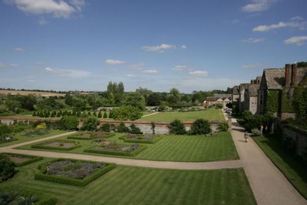
The gardens consist of four main walled enclosures (listed grade II), constructed of flint and brick. One garden enclosure is situated to the south of the House, one to the west, and two to the north, of which one is internally divided by walls into three areas. To the west the gardens are separated from the park by a ha-ha which runs along the full length of the gardens. To the north a small branch of the River Kennet that supplies water to the gardens bounds them.
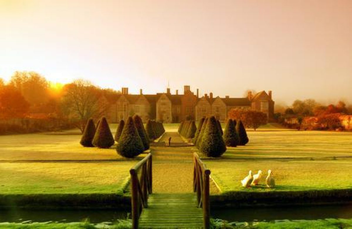
The garden to the south of the House is enclosed by a flint and brick wall c 3m high, the height of which is reduced opposite the south elevation. Here the wall is surmounted by wrought-iron railings and has a central gate with overthrow. The garden it encloses is laid to lawn with a central turning circle. Along the west wall of this garden is a raised terrace or walk which can be accessed by a central grassed mount situated on the site of former steps (painting, c 1705-10). From the terrace are extensive and fine views over the park to the west.
A doorway in the garden wall extending west of the House leads to a smaller enclosed garden which stretches out in front of the north elevation of the House, and which incorporates the chapel. This garden, laid to lawn, is bound to the south by a raised walk and to the west by the ha-ha. In the wall which extends from the House along the north side of this garden, a doorway in the far north-east corner gives access to the gardens to the north of the House. The walled garden to the far north-west of the House has late C20 greenhouses along its north-east side and is laid out as a formal parterre garden (late C20) with a central walk. The adjacent garden to its east is the largest of the series of walled gardens, and is divided into three sections by an internal wall.
Parallel to the full length of the north garden wall runs a narrow canal fed by one of the branches of the River Kennet. Along its south side is a raised paved walk, adorned by knot parterres (late C20) laid out in the recesses of the north elevation of the House. In the far north-east corner of this garden is a rectangular fishpond, landscaped in the late C18 but possibly of medieval origin (Johnson 1990). The north-east section of the compartment is laid out as a formal garden, with a central walk lined with yew trees and a circular pond at its north-east end (late C20). In the north-west corner of this garden stands an early C19 gazebo (listed grade II) built of Flemish brickwork with a tiled roof. The two smaller enclosures to the south-east of this garden are laid out as a tennis court and a bowling green.
Park
The park mainly occupies the western half of the site, including the land south of the east drive. A belt of trees lines the park along its south boundary.
Park Coppice, which is situated on top of a hill, dominates the park to the west and here the park slopes gently in a north and north-easterly direction towards the River Kennet and the House. The park is scattered with mature trees and tree stumps, except for parts of the north and east slopes of the hill which have, since the late C20, been in agricultural use. In the park, close to the River Kennet and c 400m north-west of the House, are the archaeological remains of the Roman villa (scheduled ancient monument) discovered by Sir Frances Popham in 1730. Recently (2002), a wooden canopy has been erected over the floor mosaic (restored in the 1980s) to protect it from the weather.
The park is crossed by various tracks, of which one runs along the south boundary. From the latter there is an extensive view of the park and the House that lie below it to the north, and the hills beyond. This prospect of Littlecote House from the south is depicted on the oil painting of c 1705-10.
The park to the south of the east drive is scattered with mature trees and rises gently from the line of the drive up the hill in a southerly direction. In an overgrown plantation c 200m to the south-east of the House are the remains of a late C18 icehouse with adjacent water reservoir.
REFERENCES
Country Life, 12 (27 September 1902), pp 400-09; 62 (5 November 1927), pp 664-71; 138 (25 November 1965), pp 1406-09; (2 December 1965), pp 1466-71; (9 December 1965), pp 1620-3; (16 December 1965), pp 1678-81; 139 (17 February 1966), p 367
B Cherry and N Pevsner, The Buildings of England: Wiltshire (2nd edn 1975), pp 297-9
J Harris, The Artist and the Country House (1979), p 145
J Sales, West Country Gardens (1980), pp 225-6
Victoria History of the County of Wiltshire XII, (1983), pp 28-30
Horticulture Week, (18 April 1986), p 5
Littlecote Park: Inspector's Report, (English Heritage 1990)
C Johnson, Littlecote Park Archaeological Assessment, (study for Lyons, Sleeman & Hoare 1990)
Illustrations
Oil on canvas, Littlecote House, Wiltshire, prospect from the south, c 1705-10 (private collection)
Description written: January 2002 Amended: April 2002
Register Inspector: FDM
Edited: December 2004
- Visitor Access, Directions & Contacts
Telephone
01488 682509Access contact details
There are occasional open days under the National Gardens Scheme. Tours are also available by appointment. Please see:
- History
The following is from the Register of Parks and Gardens of Special Historic Interest. For the most up-to-date Register entry, please visit the The National Heritage List for England (NHLE):
www.historicengland.org.uk/lis...
HISTORIC DEVELOPMENT
During the medieval period there was a manor at Littlecote, which was owned by the Durnford family in the 12th century. The manor came in the ownership of the Darell family in about 1415. In the late 16th century the manor house, by then called Littlecote House, was rebuilt for William Darell, and a gatehouse and garden walls were added (Victoric County History 1983). In 1589 the estate passed to Sir John Popham, later Lord Chief Justice of England, whose family owned the estate until 1929. In 1730, the then owner of Littlecote House, Sir Francis Popham, discovered the remains of a Roman villa in the park with a rare decorative floor mosaic. By the late 17th or early 18th century, Littlecote House had a series of walled gardens, with a raised walk offering views over an extensive deer park with rides and avenues, and a hunting lodge (painting, about 1705-10). Most of these features survived to the late 18th century, but not the late 16th century gatehouse (Andrews and Drury, 1773). By this period the park had been extended southwards, and a new approach had been added. During the 19th century the layout of the site remained largely unchanged, except for new planting and the addition of a lodge in the north-east corner of the park.
In 1929 Littlecote House was sold to Sir Ernest Salter Wills, whose family owned the estate until 1981. Littlecote House is currently (2002) in corporate ownership and is in use as a hotel.
- Associated People
- Features & Designations
Designations
The National Heritage List for England: Register of Parks and Gardens
- Reference: GD1451
- Grade: II
Plant Environment
- Environment
- Walled Garden
Features
- Manor House (featured building)
- Description: The house was re-built in the late-16th century.
- Earliest Date:
- Latest Date:
- Topiary
- Avenue
- Description: Yew avenue
- Rose Garden
- Garden Feature
- Description: Roman Orpheus mosaic and the remains of a villa.
- Hotel
- Key Information
Type
Garden
Purpose
Ornamental
Plant Environment
Environment
Principal Building
Commercial
Survival
Extant
Hectares
2
Open to the public
Yes
Civil Parish
Ramsbury
- References
References
- Sales, J., {West Country Gardens} (Gloucester: Alan Sutton, 1980), pp. 225-6 West Country gardens : the gardens of Gloucestershire, Avon, Somerset and Wiltshire
- {English Heritage Register of Parks and Gardens of Special Historic Interest}, (Swindon: English Heritage, 2008) [on CD-ROM] Historic England Register of Parks and Gardens of Special Historic Interest
- Pevsner, N. and B. Cherry, {The Buildings of England: Wiltshire} (Harmondsworth: Penguin, 1975), pp. 297-9 The Buildings of England: Wiltshire
- Harris, J., {The Artist and the Country House} {London: Russell Chambers, 1979), p. 145 The Artist and the Country House
- Crowley, D.A. {Victoria County History: Wiltshire, Volume 12} (London: Oxford University Press,1983), pp. 28-30 Victoria County History: Wiltshire, Volume 12
- Related Documents
-
CLS 1/191/1
1990
-
CLS 1/191/1