Introduction
Sudbury Hall has a landscape park of about 150 hectares, with pleasure grounds and the remains of a formal garden. Other features include water meadows leading down to the lake.
Terrain
The site is on land which slopes gently down from the north.www.historicengland.org.uk/listing/the-list
Pleasure grounds and parkland of the mid- to late 18th century, with gardens laid out in about 1836/7 by William Sawrey Gilpin.
DESCRIPTION
LOCATION, AREA, BOUNDARIES, LANDFORM, SETTING
Sudbury Hall lies immediately west of the village of Sudbury in an area which is otherwise rural and agricultural. The c 150ha site is on land which slopes gently down from the north and it is crossed, c 300m north of the Hall, by the A50 which was constructed in the late C20. The village main street (the A515) runs c 100m north-east of the Hall before turning to run northwards across the A50. The boundaries of the pleasure grounds are formed by the fenced edges of woodland called The Decoy north-west and west of the Hall, and the fenced edge of woodland bordering the lake to the south. A wall separates the south-east side of the site from the village. The park is bounded on the west side by the A515, excluding the fenced precincts of Sudbury Prison and Sudbury Park Farm. The remaining boundaries are formed by fences separating the site from agricultural land.
ENTRANCES AND APPROACHES
The principal entrances to the site are from the village main street. Two lodges which are linked by a ha-ha wall with a parapet (lodges and walls listed grade II) lie c 70m north-east and c 200m north-west of the Hall respectively. The lodges and wall are much as shown on the Griffier painting though it is thought that they were rebuilt in the late C18 (list description). Drives lead from them to the Hall and stable block. A separate entrance with gates lies c 100m north of the Hall and this serves the church (see below).
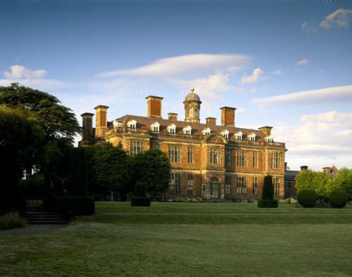
PRINCIPAL BUILDING
Sudbury Hall (listed grade I) was built for George Vernon c 1659(70. It is of brick and has a hipped roof and cupola. It is possible that George Vernon acted as his own architect and surveyor since the otherwise very complete building accounts (guidebook) mention a clerk of works but not an architect. The Hall may be the result of two separate building campaigns in which an unfinished building of c 1613 was completed by Vernon, a possible explanation for the relatively conservative plan form for a building of late C17 date. This could however simply be a reflection of provincialism, and a map of 1659 (private collection) suggests that the previous building on the site was to the east of the present building. Alterations and additions were made in the last half of the C19 by E M Barry and subsequently by George Devey. A stable block of 1661-4 is attached to the south-east side of the Hall (listed grade I with the Hall) and a late C19 stable block (listed grade II) lies south-east of this. A block of buildings around a courtyard which includes two houses, a coach house and ancillary buildings (C18 and C19, all listed grade II) lies immediately to the south-east.
All Saints' church (listed grade II*) lies within a walled churchyard c 100m north-west of the Hall. The building has C12 origins and was altered and restored by George Devey in 1872(5.
GARDENS AND PLEASURE GROUNDS
The gardens and pleasure grounds are on the south side of the A515 surrounding the Hall. There are lawns on the north side of the Hall and an area of woodland with paths leading through it, called The Decoy, to the north and west. Woodland is shown in this area on the painting of c 1700 by Jan Griffier, and on an estate map of 1794. One of the mid to late C18 paintings shows the woodland mature enough to partially conceal the church which is clearly visible on the Griffier painting.
On the south-west side of the Hall there are three grassed terraces. A central gravel path aligned with the entrance on the south-west front of the Hall leads south and intersects with another path running along the upper terrace before reaching a set of steps down to the middle terrace where there is a central circular lily pond. A further set of steps leads down from the pond to a gently sloping lawn. At the north end of the walk along the upper terrace there is a path which leads through woodland to a gateway in the churchyard wall (mid C17, listed grade II). The terraces are planted with clipped yews and formal beds of late C20 date. They were laid out c 1836(7 to a design by William Sawrey Gilpin (1762-1843) replacing a sweeping lawn shown on one of the mid to late C18 paintings and the 1794 map. Sketches and notes by Gilpin (Piebenga 1993) show that although his design was not followed exactly, the principal elements were executed and survive (1998).
Views from the south-west side of the Hall and the terraces are dominated by a large lake backed by mature planting, c 120m to the south. The lake is of elongated form running north-west/south-east on the same line as the Hall, and it is c 700m in length. At the south-east end there is an ornamental bridge (C18, listed grade II) concealing a dam. A path which runs over the bridge leads around the south side of the lake and returns through the woodland on the north-west side of the Hall. The path is shown on the 1794 map but there was no planting on the south side of the lake at that time.
The gardens replaced an extensive formal layout shown by Griffier with three walled compartments on the south side of the Hall. The central compartment had a geometrical layout with fountains and statues, and those on each side seem to have been orchards. A canal to the south of the gardens was reached from a central gateway aligned with the front of the Hall and a series of rectangular pools lay to the south of the canal. This garden was probably cleared in the mid C18 when the water features were replaced by the lake and the walled compartments by lawns.
PARK
The park lies to the north of the Hall on the north side of the A515. It is open land in a mixture of pasture and arable uses. Some 400m north-east of the Hall is the Square Pond, and c 20m north-east of this is the Deercote (c 1750, listed grade II*). This is in the form of a castle with a battlemented gatehouse, four angle turrets and a curtain wall on three sides. The building can be glimpsed from the north side of the Hall and good views of it can be obtained from the upper floors. It is shown in one of the mid to late C18 paintings with the corner towers capped by cupolas and without the gatehouse. Both the Deercote and Square Pond are shown on the 1794 map.
Grove Plantation, on the east side of the park, c 1.3km north-east of the Hall, is the remains of an extensive tree belt which is shown sheltering the eastern boundary on the 1794 map. In the northern part of the park a patch of woodland called Oak Rough is shown on the1794 map which also shows the A515 (western boundary) as an avenue for most of its length. Maps and paintings of the C18 and C19 show that the park was well wooded but relatively little tree cover survives (1998).
KITCHEN GARDEN
The kitchen garden lies c 120m north-west of the Hall from which it is concealed by planting. It consists of a brick-walled enclosure (listed grade II) within which a private house is sited (1998). It is shown on the 1794 map and the 1880-1 OS map shows it divided into compartments and planted with trees.
REFERENCES
Country Life, 77 (15 June 1935), pp 622-627; (22 June 1935), pp 650-656
Sudbury Hall, guidebook, (National Trust 1973).
N Pevsner and E Williamson, The Buildings of England: Derbyshire (2nd edn 1978), pp 330-335
J Anthony, The Gardens of Britain 6, (1979), pp 152-154
S Piebenga, William Sawrey Gilpin (1762-1826), (English Heritage Designer Theme Study 1993)
Maps
Estate map, 1794 (private collection)
OS 6" to 1 mile: 2nd edition surveyed 1880-1881, published 1890
Description written: August 1998
Amended: March 1999
Edited: November 1999
- Visitor Access, Directions & Contacts
Telephone
441283585337Access contact details
The hall is open Wednesdays to Sundays between February and October. The grounds are open daily between February and December. http://www.nationaltrust.org.uk/place-pages/321/pages/opening-times-calendar
Owners
The National Trust
Heelis, Kemble Drive, Swindon, SN2 2NA
- History
The following is from the Register of Parks and Gardens of Special Historic Interest. For the most up-to-date Register entry, please visit the The National Heritage List for England (NHLE):
www.historicengland.org.uk/listing/the-list
HISTORIC DEVELOPMENT
The site was owned by the Vernon family from 1513, although they did not take up residence until the later 16th century. The family took the additional name Venables in 1728 after the Venables' estates in Cheshire were inherited by George Vernon, who was created a baron in 1762. The Hall was painted from the south-west in about 1700 by Jan Griffier (guidebook fig 1), and a group of three mid- to late 18th-century paintings (guidebook figs 35-37) show it from various viewpoints after a formal garden shown by Griffier had been replaced. The estate remained in the family until 1967 when the Hall and part of the garden and park were given to the National Trust. The site remains in divided ownership between the family and the National Trust (1998).
- Associated People
- Features & Designations
Designations
The National Heritage List for England: Register of Parks and Gardens
- Reference: GD1675
- Grade: II
Features
- Lake
- Great House (featured building)
- Description: Redbrick hall.
- Earliest Date:
- Latest Date:
- Formal garden
- Water Garden
- Key Information
Type
Park
Purpose
Ornamental
Principal Building
Domestic / Residential
Survival
Extant
Hectares
150
Open to the public
Yes
Civil Parish
Sudbury
- References
References
- {English Heritage Register of Parks and Gardens of Special Historic Interest} (Swindon: English Heritage 2008) [on CD-ROM] Historic England Register of Parks and Gardens of Special Historic Interest
- Pevsner, N and Williamson, E {The Buildings of England: Derbyshire} (Harmondsworth: Penguin, 1978) pp 330-335 The Buildings of England: Derbyshire
- Anthony, J. {The Gardens of Britain 6: The East Midlands} (London: Batsford, 1979) 152-4 The Gardens of Britain 6: The East Midlands