Introduction
The estate, which is now in divided ownership, contains two lakes, formed from canals which existed in the 17th-century formal gardens. The former walled garden contains a garden centre. The former stables now houses The Ferrers Centre for Arts and Crafts. The site is surrounded by a rolling landscape, which is the result of a number of phases of development spanning six centuries. Pevsner described its position as \"unsurpassed in the country - certainly as far as Englishness is concerned\".
Terrain
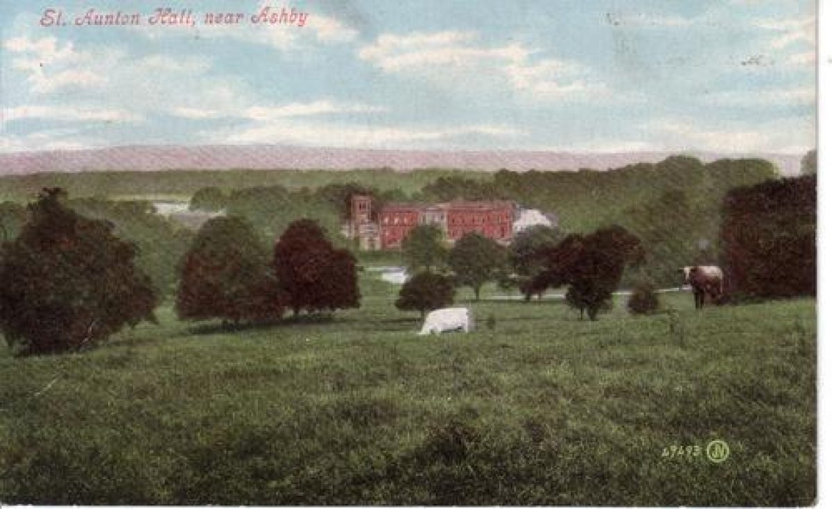
Staunton Harold Hall stands in a small valley.www.historicengland.org.uk/listing/the-list
A landscape park of 1760s associated with a contemporary country house; the park incorporates some elements of extensive formal gardens laid out in later 17th century.
DESCRIPTION
LOCATION, AREA, BOUNDARIES, LANDFORM, SETTING
Staunton Harold Hall stands in a small valley 5km north-east of Ashby-de-la-Zouch. To the east the park is partly bounded by the B587 road from Ashby to Melbourne, and to the south-west by a track. Otherwise the boundary follows field edges. The area here registered is c 90ha.
ENTRANCES AND APPROACHES
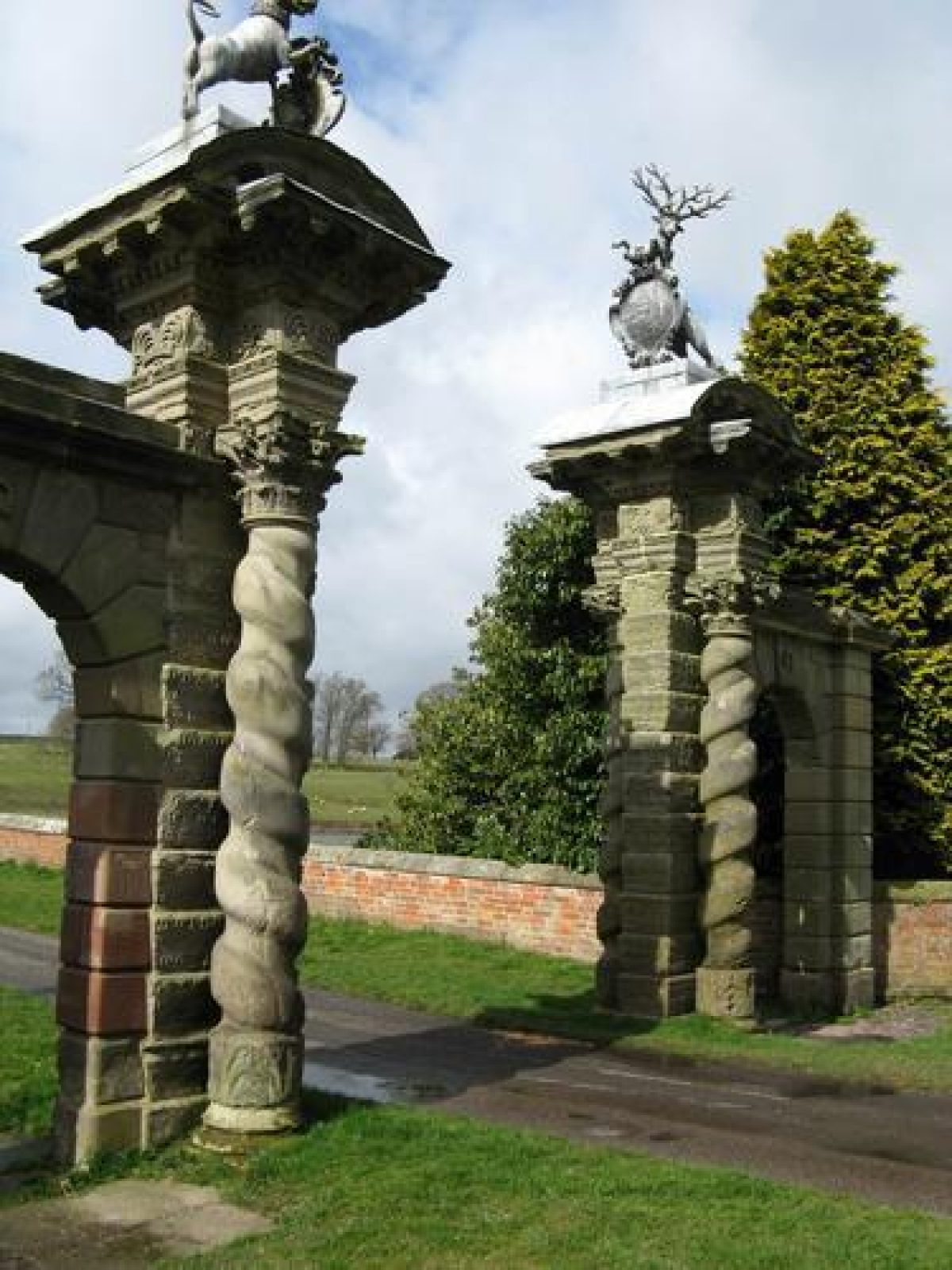
The principal, and most scenic, approach is from the north-east, via an entry to the park adjoining the Melbourne Lodge, a two-story brick lodge of the mid C19. This was probably also the main approach in the C17. From here a drive runs south, downhill, before turning a right-angle to begin a straight approach to the Golden Gates (listed grade II*), an ornate stone structure in the Baroque manner of the late C17, with late C18 pedestrian archways to either side. Surmounting it are the Shirley supporters of a hound and stag. The Gates, moved here at an unknown date from what Country Life (1913, 526) claimed was the entrance to the bowling green, lie at the east end of a brick causeway bridge (also listed grade II*) across the north end of Church Pool, from which there is a fine view across the water to the south-east front of the Hall and the chapel. The drive now continues north of the Hall, to link up with that from the west, although the main historic destination was a gravel turning circle (no longer extant) before the south-east front.
Another approach is from the south-east, via the kilometre-long drive from the entrance adjoining the early C19, single-storey, Ashby Lodge (listed grade II). Some 200m north-west of this, on the west side of the drive, is the C18 Coach Road Cottage (listed grade II). This drive runs along the east side of Church Pool, giving a view across it to the Hall, before joining the drive from Melbourne Lodge east of the Golden Gates.
The third main approach is from the west, via an 800m long tree-lined drive from Heath End which approaches the rear, west side of the Hall between on the one (south) side the kitchen gardens and on the other the stables and Home Farm.
A deep and wide hollow way cut in the steep hillside east of the right-angle turn in the drive east of Golden Gates marks the line of a drive formerly carried via a straight elm-lined avenue east from north of Hilltop House (outside the registered area) for 1.5km.
PRINCIPAL BUILDING
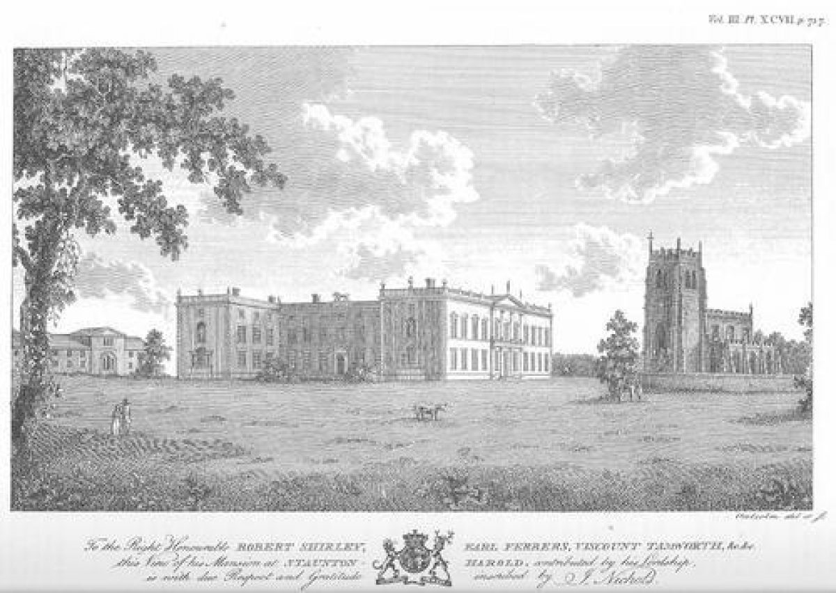
Staunton Harold Hall (listed grade I) is a two-storey brick building, low, wide-spreading and ranged around a quadrangle, largely the product of a building campaign begun in 1763 although incorporating a Jacobean house altered c 1700. It is uncertain how much of the remodelling of 1763 should be attributed to the fifth Earl, and how much to his clerk of works William Henderson (or Anderson) of Loughborough, who lived at Staunton from 1762-72. The north-east front, of c 1700, is of five bays, that to the south-east (1763 and later) of eleven, the centre three of ashlar under a pediment, while to the south-west projecting wings embrace the Lion Court. This takes its name from the figure of a lion on its facade, one of several sculptures with which the exterior is adorned.
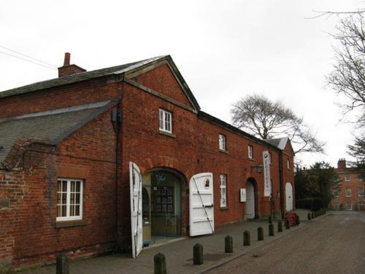
A late C18 brick stables complex (listed grade II) stands c 100m north-west of the Hall, slightly uphill and effectively behind it. West of this is the impressive C18 Home Farm.
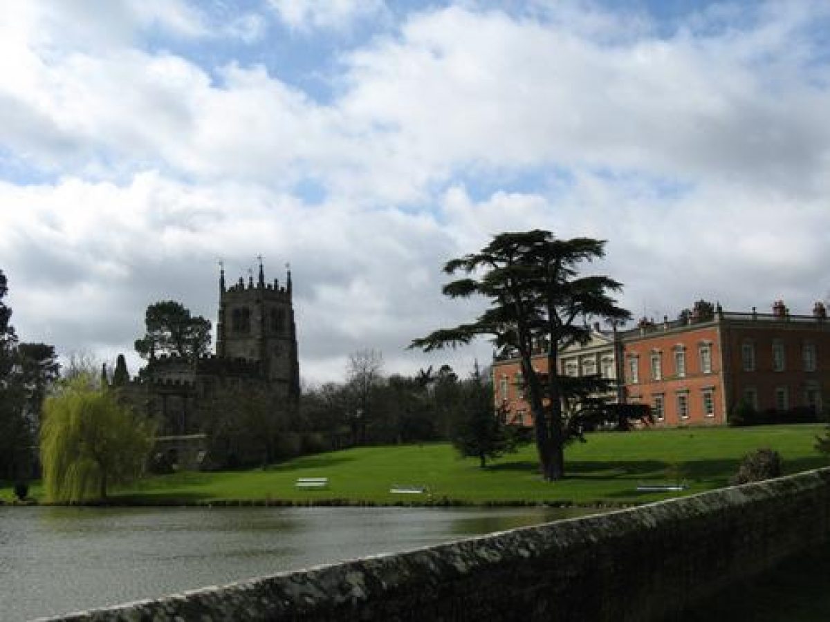
The chapel of the Holy Trinity (listed grade I) of 1653 stands on the shore of Church Pool 50m south-east of the Hall, within a tall stone wall (listed grade II). Of stone and in the gothic style, the chapel comprises west tower, nave, chancel and aisles.
GARDENS AND PLEASURE GROUNDS
The Lion Court is occupied by a formal garden completed in 1990 with box hedges and brick-edged beds. South-west of this, extending to a walled ditch, is a lawn. This is terraced along its north-west side, presumably as part of the improvements to this part of the grounds undertaken 1828-9 (see below). Specimen trees around its edge may also be early C19. A bridge crosses the ditch to a low-lying area of woodland and shrubs, bounded to the south-west by a yew-edged path, again probably part of the work of 1828-9, which runs north before turning along the outside of the south-east wall of the kitchen gardens. There are also lawns south-east and north-east of the Hall which run down to Church Pool and the Fish Pond. On the north-west side of the Hall is a car park.
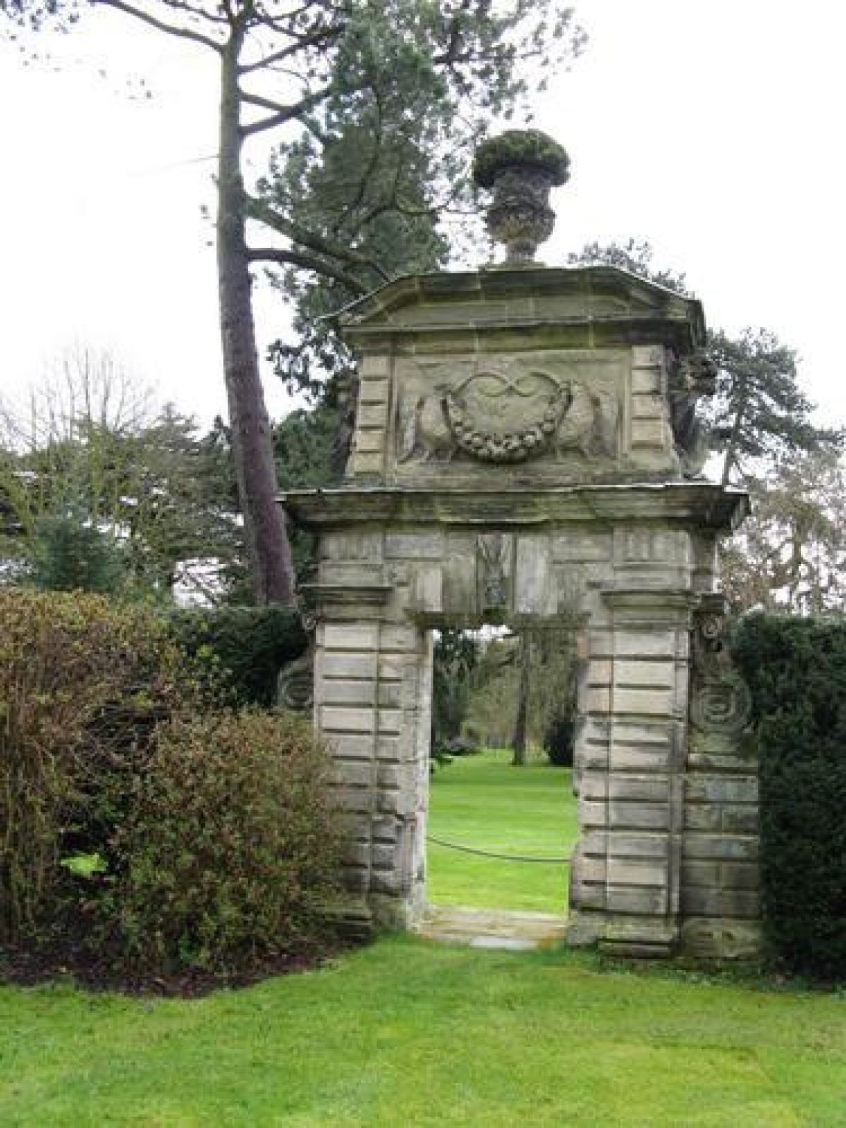
Adjoining the south-west side of the chapel yard wall is a stone gateway (The Gate to Nowhere) of 1681 (listed grade II*) in the baroque manner, the rectangular panel above the doorway being carved with foliate swags, eagles and cornucopia buttresses. This is surmounted by a pediment with urn. The gateway originally stood on the north-west edge of the main formal gardens, and was presumably moved here when they were swept away in the 1760s.
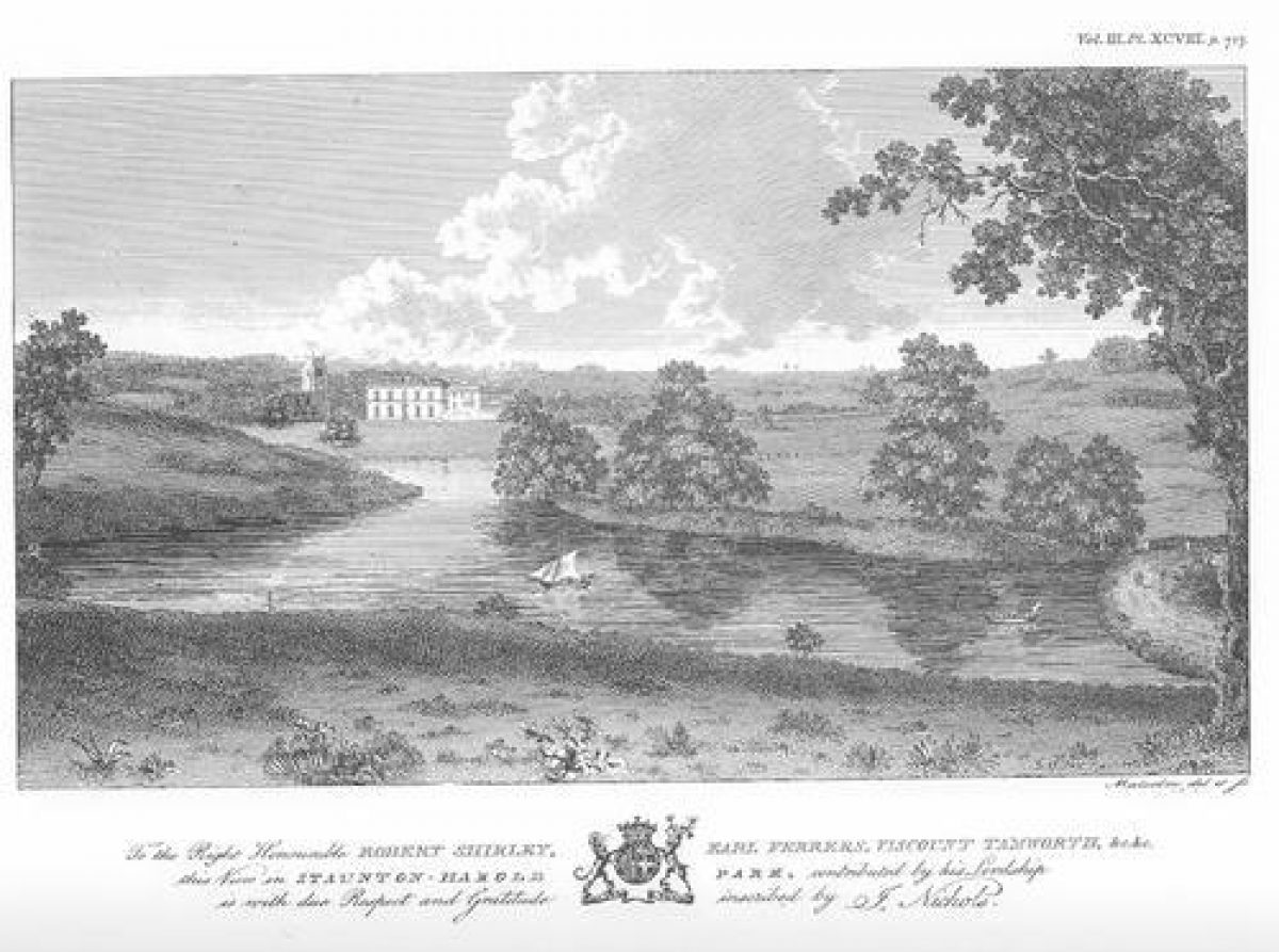
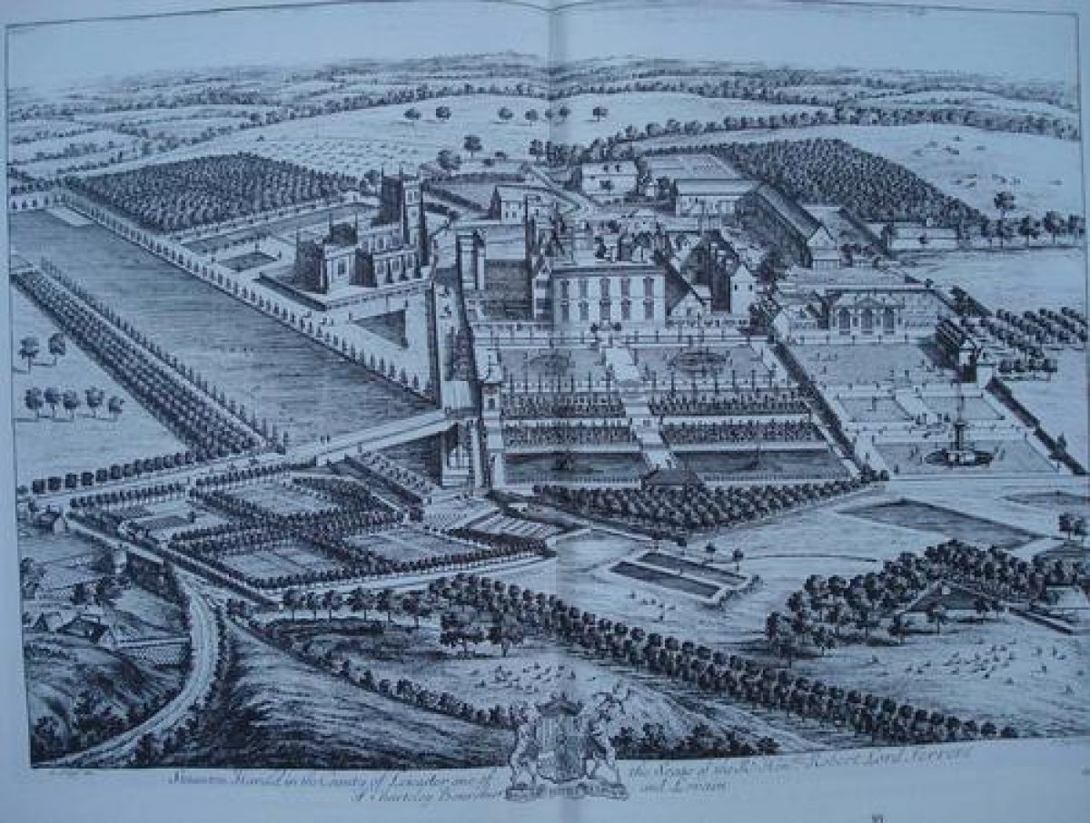
Those formal gardens, shown on a painting of c 1702 attributed to Leonard Knyff and on a view of 1706 by Kip and Knyff (Harris 1995; Cantor & Squires 1997), were laid out by Baron Ferrers c 1680. There is no record of who was responsible for their design. The main garden, with terraces ranged either side of a broad axial path and with a canal across the bottom, lay north-east of the Hall. A summerhouse at the east end of the main cross axis adjoined the west end of a predecessor of the present causeway bridge, to the south of which, past the chapel, extended the rectangular Church Pool. West of the southern part of the Pool was a roughly square block of woodland, possibly a wilderness, although that name is not associated with the area until the Ordnance Survey map of 1887. Further pools lay along the valley bottom north of the Hall and gardens. Woolley, in 1711 (171), notes the gardens as 'well watered with fountains and canals, very good aviaries and a decoy and a great many exotic waterfowls. The gardens lie on the north-west [sic] of the house, consisting of several parterres of easy descent from the house, which add a gracefulness to the one and the other.'
The fifth Earl Ferrers may have ordered the removal of the formal gardens soon after inheriting the estate, and a painting of Staunton Harold attributed to Thomas Smith (d 1767) (Harris 1979) shows the landscape much as now. Perhaps the main change, other than the removal of the formal gardens, was the creation of the present Fish Pond north of the causeway bridge.
In 1828-9 a new pleasure ground was laid out in the area between Hall, chapel and Wilderness under the direction of Christopher Chamberlain. Among the elements were a parterre and a gothick conservatory. These were largely removed in the early C20.
PARK
The Hall lies in the southern part of a landscape park, presumably created c 1763 about the time the old formal landscape around the Hall was swept away. The park comprises a one kilometre long section of a valley whose bottom is largely occupied by two sheets of water: Church Pool, and to its north the longer Fish Pond, the latter fed with water via a weir at its southern extremity. The pools form the key elements of the two main views from the Hall. The first is from its south-east front, past the chapel, across Church Pool to the lush grassland rising beyond. Midway up the hillside is a stone conduit house (listed grade II), probably C17. The second view, much longer, is from the north-east front, north along the valley and Fish Pond. The west side of the valley is pasture ground and fairly open, while the east bank of the pool and the valley side is well wooded. A stone wall bounds the north-east side of the park, and can be seen from the Hall running along the skyline. A second length of stone wall adjoins Heath End on the west side of the park.
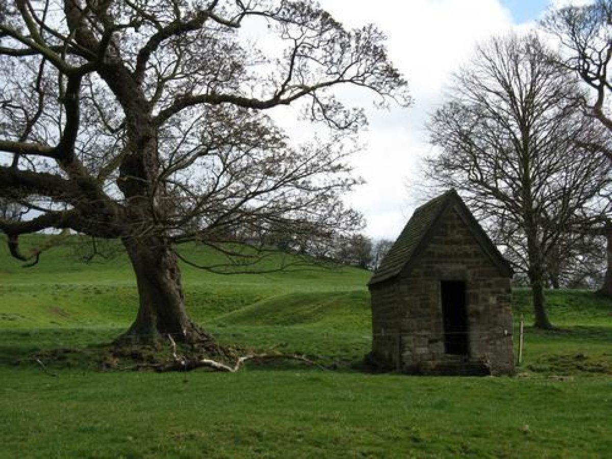
The conduit house, 250m east of the Hall, stands amidst a complex pattern of earthworks. Some of the earthworks are likely to be associated with the later C17 formal gardens, while others, including hollow ways and some ridge and furrow, may represent the site of the medieval village of Staunton Harold. Contour paths running around the slight spur 150m east of the conduit house may indicate the line of a walk intended to enjoy the fine view west to the Hall and chapel. North of the conduit house is a stone cistern.
There was a deer park at Staunton by 1324, and later two, the Little Park and the Great Park. The Little Park is believed (Chris Burnett Assocs 1995, para 2.10) to have occupied the present parkland area. Nichols (1804) reports that the fifth Earl disparked it c 1763 but that the pale was reinstated at the beginning of the C19. The Great Park (disparked 1623) lay east of the registered area, centred on Staunton Lodge.
Major changes followed the break up of the estate in 1954. The avenues approaching the Hall were felled in the late 1950s, as were beeches on the horizon line adjoining the park wall. By 1960 The Wilderness had been felled and replaced by a poplar plantation.
KITCHEN GARDEN
The brick-walled kitchen gardens, 130m east/west by 90m north/south, are now occupied by a garden centre. They lie 200m west of the Hall and south of the stables and Home Farm. No glasshouses survive. Some of the walling is probably C18, while other stretches probably date from the 1820s and 1830s when major improvements to the kitchen gardens are documented. Outside, and north-west of the garden, is a pair of estate cottages of c 1900.
These gardens presumably replaced the unwalled productive gardens, which Kip and Knyff's view of 1706 shows immediately north-east of the east end of the causeway bridge. It would seem likely that the productive gardens were removed c 1763, and certainly there is no sign of them on Smith's view of the mid 1760s.
REFERENCES
J Nichols, History and Antiquities of Leicester 3, part ii (1804), pp 712-18 (4 volumes, in 8 parts, 1795-1811, reprinted 1971)
W Woolley, History of Derbyshire (1711) (C Glover and P Riden (editors), Derbyshire Record Society 6, (1981))
Country Life, 33 (5 April 1913), pp 490-8; (12 April 1913), pp 526-30; 107 (24 February 1950), pp 516-19
Transactions of the Leicestershire Archaeological History Society 46, (1970-1), p 23
R F Hartley, The Medieval Earthworks of North West Leicestershire (1984)
Staunton Harold Park: Restoration Management Plan, (Chris Burnett Associates 1995)
J Harris, The Artist and the Country House (1995), pp 47, 67
L Cantor and A Squires, The Historic Parks and Gardens of Leicestershire and Rutland (1997), p 53
The Wilderness, Staunton Harold: A Brief History, with some Proposals for Restoration, (John Samuels Archaeological Consultants 1998)
MAPSOS 6" to 1 mile:
Leicestershire sheet 9 SW, 1st edition 1887; 2nd edition 1901; 1924 edition
Leicestershire sheet 16 NW, 1st edition 1887; 2nd edition 1904; 1927 edition
OS 25" to 1 mile:
Leicestershire sheet 16.2, 1st edition 1881
Description written: May 1998
Edited: July 1999
Amended: January 2003
- Visitor Access, Directions & Contacts
Telephone
01332 864435Access contact details
The Hall and its immediate environs are in private ownership and are not accessible to the public, except occasionally for functions and private visits. The surrounding park and former stables (Ferrers Centre) are open to the public. The Church in front of the Hall is owned by the National Trust, as are the Golden Gates. The former walled garden contains a garden centre, also open to the public. http://www.nationaltrust.org.uk/place-pages/312/pages/opening-times-calendar
Directions
Staunton Harold Hall is situated 5 kilometres north-east of Ashby-de-la-Zouch, just off the B587, Ashby to Melbourne Road.
- History
Staunton appears in the Domesday book as one of 210 ‘lordships' granted to Henry de Ferraris by William of Normandy, after the Conquest. It was then ‘enfeoffed' (leased) to a feudal Saxon underling, Harold de Lecha. It became known as Staunton Harold to distinguish it from other Stauntons (stony towns) throughout the country.
There was a deer park at Staunton by 1324 and later, two - the Little Park and the Great Park. The Little Park is believed (Chris Burnett Assocs. 1995) to have occupied the present parkland area and therefore is of particular importance at Staunton Harold as a continuous feature of the landscape from that date.
In 1423, Ralph Shirley, one of Henry V's leading commanders at Agincourt, married Margaret, Heiress of John de Staunton. The Staunton estate was then in the ownership of the Shirley family until 1954.
There is no documentary evidence to suggest any designed landscape at Staunton Harold before the mid to late 17th century, although there would have been gardens, orchards and farms to support the community associated with the house.
In 1611, George Shirley was created 1st Baronet Ferrers by James I. This was a hereditary title.
In 1623, the Great Park was disparked and turned into farms.
In 1653, Sir Robert Shirley, the 4th Baronet, built a church next to the Hall. It is a particularly significant building as it is the only church built in England during the period of the Commonwealth. See the Historic England Register entry below for more information on this.
Shirley's son, who was created Baron Ferrers in 1677, and Earl Ferrers in 1711 set about ‘aggrandising the hotch potch of Jacobean and earlier buildings which he had inherited' ("Back from the Brink" - John Blunt). He added a new north-east front to the Hall and laid out extensive formal gardens around it. The location of the Church would have dictated the position of these gardens, which might otherwise have been positioned to the south of the house.
A contemporary described Shirley as 'a great improver of gardening and parking' (Country Life 1913, 526). There is no record of who was responsible for their design although Country Life 1913 states that "it is probable that George London who had laid out the neighbouring gardens at Melbourne may have advised him. London certainly knew the garden and writes in 1701 to Thomas Coke of Melbourne of two visitors setting out to see gardens and plantations proposing to see "My Lord Chesterfield's, Lord Ferrers' and the Duke of Devonshire's"
The Hall and gardens were illustrated by Leonard Knyff (around 1702) and engraved by Kip (1706).
The report by Chris Burnett's Associates(1995) describes them, from the engraving, thus: "The main garden, terraces ranged either side of a broad axial path and with a canal across the bottom, lay north-east of the Hall. A summerhouse at the east end of the main cross axis adjoined the west end of a predecessor of the present causeway bridge, to the south of which, past the chapel, extended the rectangular Church Pool. West of the southern part of the Pool was a roughly square block of woodland, possibly a wilderness, although that name is not associated with the area until the Ordnance Survey map of 1882. Further pools lay along the valley bottom north of the Hall gardens."
Nichols quotes a Mr Wooley's description of the garden in 1712 from his MS History of Derbyshire as follows:
"It has a handsome new front towards the gardens... the gardens are well-watered with fountains and canals, very good aviaries, a decoy, and stations for a great many exotic fowls. The park and woods about it are large and reach within half a mile of Caulk (sic) and a mile of Melbourne but being seated in a clay soil, it is somewhat dirty coming to it....the east end of the church abuts on a very large canal, the biggest in all the county." According to Nichols, the gardens lie on the north west side of the house, but, in fact, they lie to the north-east "consisting of several parterres in easy descents from the house, which add a gracefulness to the one and the other."
The height of one of the fountains was enhanced by the water being thrown from and then spilled down over a prominent stone column, not unlike the giulio in the Octagon Lake at Stowe. ("Sir John Vanburgh and Landscape Architecture in Baroque England 1690-1730") This can be seen on the Kip engraving.
According to Nichols, MacKay in his tour through England early in the reign of George I, calls Staunton Harold "a noble seat... and the gardens adorned with statues"
For the first half of the 18th century, there were few changes. The English Heritage entry below describes this period: the 2nd and 3rd Earls died as minors and the 4th Earl, Laurence Shirley, lived a violent and dissolute life. In 1760, he was hanged for the murder of the steward, who had been appointed by the Countess's family to protect her interests.
He was succeeded by his brother, Washington Shirley, who had been an Admiral in the Navy. He was a patron of the arts and an amateur architect. It was he who swept away the buildings and terraces which can be seen in the Kyp engraving and created the house and gardens much as we see them today. Work on the house started in 1761, adding the eleven-bay Palladian south-east front and the projecting wings to the (south-west) Lion Court. The stables, now the Ferrers Centre, were built some 20 years later.
A painting of Staunton Harold attributed to Thomas Smith (who died in 1767) shows the landscape much as now.
The park comprises a one kilometre long section of a valley, whose bottom is largely occupied by two sheets of water.
In 1804, Nichols describes it as follows:
"A fine sheet of water, or lake of considerable extent, adorned with swans, runs through the great part of it; at the upper end of which is a pond of seven acres, constituting a fine piece of water called "The Church Pool" over the lower end of which and next the lake is built a handsome bridge, corresponding with the house. The lake covers a space of between 20 and 30 acres and is 18 or 20 feet deep about the widest part; it is half a mile long, about a quarter of a mile wide and the head of it is a remarkable height..."
The late 1820s saw the introduction of a Pleasure Ground south and east of the house. A lawn was laid and specimen trees were planted around its edges. A yew-edged path crossed a ditch to a low-lying area of woodland and shrubs. This runs north, before turning along the outside of the south-east wall of the kitchen gardens.
This was, in effect, a second development of formal gardens. At the same time, other alterations were made to the estate including new drives and the expansion of the walled gardens. An extensive and splendid conservatory was erected at this time.
The 10th Earl, who inherited in 1859, built or rebuilt many of the properties on the estate but the revenue from the estates was not sufficient to maintain them and he left his successors heavily in debt.
In the 1890s a private golf course was introduced to the northern part of the park.
The Hall was requisitioned by the army in 1940. It was occupied first by the army and then by Italian and finally Germany prisoners of war. After WWII, some of the contents were sold in 1949.
Finally the 12th Earl, unwilling to saddle his son with the financial burden that he had born, put the estate up for sale. In 1954 the Hall and estate lands were sold to different owners and the church given to the National Trust. Major changes followed the break-up of the estate: the avenues approaching the Hall were felled in the late 1950's, as were beeches on the horizon line adjoining the park wall. By the 1960s the Wilderness had been felled and replaced by a poplar plantation. The Hall became a Cheshire Home in 1954, and in 1985 was sold to the Ryder-Cheshire Mission. It was a palliative Care Home until 2002.
During this time, in 1990, a formal garden with box hedges and brick-edged paths was constructed in the Lion Court, to the south-west of the Hall. This was designed by the Leicestershire County Council in consultation with the National Trust.
Since 2003, the Hall has been in private ownership.
The following is from the Register of Parks and Gardens of Special Historic Interest. For the most up-to-date Register entry, please visit the The National Heritage List for England (NHLE):
www.historicengland.org.uk/listing/the-list
HISTORIC DEVELOPMENT
The Shirley family held Staunton from the 15th century to 1940. They acquired it in 1423, when Ralph Shirley married Margaret, heiress of John de Staunton, whose family had held the manor since the 12th century. In 1653 Sir Robert Shirley, fourth baronet Ferrers, who had inherited the estate in 1646, built a chapel next to the Hall. Shirley was a Royalist, and it has been argued that its construction was an act of political and religious defiance, rather than a purely practical measure intended to avoid the eight-kilometre journey to the parish church at Breedon-on-the-Hill. It is one of only a handful of ecclesiastical buildings new-built during the Commonwealth. Shirley's second son, created Baron Ferrers in 1677 and Earl Ferrers in 1711, added a new north-east front to the Hall and laid out extensive formal gardens around it. A contemporary described him as 'a great improver of gardening and parking' (Country Life 1913, 526). Thereafter, for sixty years, there were few changes; the second and third Earls died as minors, while the fourth Earl 'led a dissolute life, drank heavily and neglected his estates' (quoted, unsourced, in Chris Burnett Associates 1995) before being hanged for the murder of his steward in 1760. In the years after 1763 the fifth Earl, formerly Admiral Washington Shirley, added the eleven-bay Palladian east front to the Hall and the projecting wings which enclose the Lion Court. At the same time the formal gardens were swept away and the canals made into lakes.
The Hall was requisitioned by the army in 1940. Its contents were sold in 1949, and in 1954 the Hall and estate lands were sold to different owners and the church given to the National Trust. The Hall became a Cheshire Home in 1954, and in 1985 was sold to the Ryder-Cheshire Mission which remains the owner (1998).
Period
- 18th Century (1701 to 1800)
- Late 18th Century (1767 to 1800)
- Features & Designations
Designations
The National Heritage List for England: Register of Parks and Gardens
- Reference: GD1468
- Grade: II*
Style
English Landscape Garden
Features
- Lake
- Description: The Church Pool and North Lake are the two main water features surviving on the estate today. The Church Pool was created from the long canal seen as a rectilinear sheet of water in the Kip engraving (dated approximately 1706). Nichols refers to it as ?the Church Pool? in 1804 but on the first edition OS map (1882) it is called Fish Pond. The date of the islands is unclear. A second canal is shown on the Kip engraving together with further fish ponds. This group disappeared with the creation of the North Lake, as part of the mid-18th century landscaping.
- Latest Date:
- Gate Lodge
- Description: Melbourne Lodge was built in the 19th century at what was probably the oldest approach to Staunton Harold.
- Earliest Date:
- Latest Date:
- Chapel
- Description: The Chapel of the Holy Trinity Church is unique as a complete survival of a church built during the commonwealth. Begun in 1653, the church and its furnishings were not completed until 1665. It is built in a gothic style, but a highly wrought and careful gothic. The west tower, short nave of three bays with clerestory and aisles and the chancel are very sharply articulated. The tower has paired bell openings with Y-tracery and battlements and pinnacles with wind vanes. The body of the church has embattled parapets with crocketted pinnacles over the buttresses. Flat-headed tracery lights are in the clerestory. Other windows are done in an early decorated style. The elaborate Baroque west doorway has paired tapering pilasters, swags, mannerist angels and Shirley arms with an inscription plate above. The interior has gothic-style architecture but the fittings are all in Jacobean character. The original west door has an ornate west screen with a pierced central archway and side arches. There is a pierced leaf scroll frieze above and a panelled base. Above this, the organ loft incorporates the Shirley arms in a broken segmental pediment. The Schmidt organ has a case dating to 1686. There are box pews, wall panelling and casing for the piers. There are plain panels to the nave which are more ornate in the chancel. There is a two-decker pulpit, chancel screen, wrought iron by Robert Bakewell- 1711 and four hatchments over. The ceiling is painted throughout with a curious depiction of clouds and elements - the creation out of chaos, signed by Samuel and Zachary Kink, and dated 1655. The communion table is also original, approximately 1660-65.
- Earliest Date:
- Latest Date:
- Entrance
- Description: The Golden Gates Ornate gateway is late 17th century Baroque. The rusticated stone piers and barley sugar Ionic columns bear entchlatures and segmental pediments. They are flanked by late 18th century pedestrian archways with round arches and rusticated with entchlatures. The gateway formerly contained wrought iron gates and a heraldic crest. Shields once capped the piers. The gate piers were originally at the entrance to the bowling green in the formal gardens laid out by the 1st Earl Ferrers. They were probably moved to their present position by the 5th Earl when he re-landscaped the area; the outer pedestrian archways probably date from this period. The hound and stag on the top of the piers are the supporter of the Shirley family coat of arms.
- Earliest Date:
- Latest Date:
- Gateway
- Description: The Gateway to the Garden is also known as the Gateway to Nowhere. The Gateway was moved from its original site. It is dated 1681 and is in a Baroque manner. The lower stage has a square-headed doorway in rusticated surround, with a keystone, and rusticated Doric plasters, consoles on rusticated flanking walls, and a cornice over it. Above this is a tall rectangular panel with foliate swags, eagles, and rusticated pilasters with cornucopia buttresses. Above the cornice is a shallow flat-headed pediment bearing an urn. The Gateway was originally within the elaborate 17th century gardens established by the 1st Earl Ferrers. It was probably moved to its current location in the 1760s by the 5th Earl, during his remodelling of the Hall and Park.
- Earliest Date:
- Latest Date:
- Ornamental Bridge
- Description: A shallow spanned bridge over the lake, brick, with stone copings to parapet. This is linked to the Golden Gates.
- Earliest Date:
- Latest Date:
- Stable Block
- Description: The stable block is late 18th century and is a brick quadrangle. The east range has two-storeys, nine bays and a central pavilion. There is a Palladian window in a recessed arch to the ground floor and a triple-light sash window above. Many window spaces are blind, but all have stone sills and fine-gauged heads. There is a stone string course and eaves cornice. The south front has a wide three bays between two pedimented and slightly projecting end bays. The double coach doors have segmental arched heads. The block was built by the 5th Earl Ferrers, principally for stabling. It also contained coach houses, a granary, accommodation for unmarried staff, a dovecote and the blacksmith forge, which is still in use. It is now called The Ferrers Centre and has been a craft centre since 1978.
- Earliest Date:
- Latest Date:
- Garden Building
- Description: The Conduit House is probably 17th century. It is a small single storey rubble structure of one room. There is one small window to the rear with a chamfered stone surround on the front. There is a nail studded door, slate roof and lined pool for water within. This small building protects a spring-fed stone tank. The spring was probably the water supply for the medieval village of Staunton Harold which occupied this site and disappeared centuries ago.
- Earliest Date:
- Latest Date:
- Structure
- Description: The Chapel Yard Walling, gate piers and gates walling are mid-17th century with ashlar with coping and angle buttresses. The ashlar gate press has heraldic friezes, cornices and ball finials. The wrought iron gates with twisted shafts and ornate crestings are 17th ? 18th century.
- Earliest Date:
- Latest Date:
- Kitchen Garden
- Description: It is believed that the kitchen gardens were moved to their present position in the mid-18th century, as part of the landscaping scheme. Major improvements were made in the late 1820s and 1830s, probably in association with the construction of the pleasure grounds. According to a survey of 1859, the size of the kitchen garden was three acres. The sale particulars of 1954 supply details: size about three acres, (this corroborates the information given in a survey of 1859) enclosed by a high brick wall and divided into four main areas. There were small additional areas of garden outside the wall on the south and west. Glasshouses included tomato houses, cucumber, carnation house and two heated fern pits. There was also a boiler house, a tool shed, mushroom house, two potting sheds, a flower room and office and store shed. The small remaining range of glasshouses and the peach house (now a cafe) were manufactured by Foster and Pearson of Nottingham. The kitchen garden is now a commercial garden centre.
- Earliest Date:
- Latest Date:
- Conservatory
- Description: This was built between 1829 -1831 as part of the general improvements to the ?Pleasure Ground?. It was situated to the south of the house and was described as ?an extensive and splendid conservatory? built ?on the latest and most approved principle?. It was a gothic structure with pinnacles and castellation. It is no longer in existence and is believed to have been demolished following damage from a severe hail storm.
- Earliest Date:
- Latest Date:
- Great House (featured building)
- Description: The Hall, largely rebuilt in 1763, incorporated an earlier Jacobean house. The exterior ? brick with stone dressings - is built round a quadrangle. The east-facing, principal front is two storeys, having 11 bays and a pedimented centre piece with Tuscan and Ionic columns and a triglyph frieze. The south front has three storeys with projecting wings, forming the lion court.
- Earliest Date:
- Latest Date:
- Icehouse
- Description: This is probably 18th century and is located on private land near the Ferrers Centre. It is brick-lined.
- Earliest Date:
- Latest Date:
- Key Information
Type
Estate
Purpose
Ornamental
Principal Building
Commercial
Period
18th Century (1701 to 1800)
Survival
Part: standing remains
Hectares
90
Open to the public
Yes
Civil Parish
Staunton Harold
- References
References
- Hussey, C {English gardens and landscapes 1700-1750} (London: Country Life, 1967) English gardens and landscapes 1700-1750
- Kip, J and Knyff, L {Britannia Illustrata, Vol. 1} (London: Mortier, D., 1707) Britannia Illustrata, Vol. 1
- {English Heritage Register of Parks and Gardens of Special Historic Interest}, (Swindon: English Heritage, 2008) [on CD-ROM] Historic England Register of Parks and Gardens of Special Historic Interest
- Pevsner, N and others {The Buildings of England: Leicestershire and Rutland} (Hardmondsworth: Penguin, 1984) The Buildings of England: Leicestershire and Rutland
- Ridgeway, C and Williams, R {Sir John Vanbrugh and Landscape Architecture in Baroque England 1690-1730} (Stroud: Sutton Publishing Ltd., 2000) Sir John Vanbrugh and Landscape Architecture in Baroque England 1690-1730
- Harris, J {The Artist and the Country House} (London: Russell Chambers, 1979) The Artist and the Country House
- Fox J. {Staunton Harold} (Kairos Press, 2001) Staunton Harold
- Nichols J. {The History and Antiquities of the County of Leicester Vol III Part II} (1804) The History and Antiquities of the County of Leicester Vol III Part II
- Throsby J. {Select Views in Leicestershire from Original Drawings ocontaining Seats of the Nobility, Gentry, Town Views and Ruins accompanied with Descriptive and Historical Relations} (1789) Select Views in Leicestershire from Original Drawings ocontaining Seats of the Nobility, Gentry, Town Views and Ruins accompanied with Descriptive and Historical Relations
- Woolley, W {History of Derbyshire} (Derbyshire Records Society, 1981) History of Derbyshire
- Chris Burnett Associates {Staunton Harold Park Restoration Management Plan} (1995) Staunton Harold Park Restoration Management Plan
- Blunt, J {Back from the Brink} Back from the Brink
- {Staunton Harold Visitors' Guide} Staunton Harold Visitors' Guide
- The National Trust {Staunton Harold Church} (The National Trust) Staunton Harold Church
- {Staunton Harold Hall} (Country Life, 1913) Staunton Harold Hall
- Rutley, K.F. and German J. {The Staunton Harold Estate, Leicestershire, Sale Catalogue} (1954) The Staunton Harold Estate, Leicestershire, Sale Catalogue
- {The Shirley Collection} (Unpublished) The Shirley Collection
Contributors
Sue Blaxland
Sheila Burnage