Introduction
Calke Abbey has a landscape park, pleasure grounds and walled garden, now occupying about 210 hectares, surrounding a hall. The National Trust has restored much of the site and the parkland is now a National Nature Reserve.
Terrain
The site is on rolling land which falls to the south and east.The following is from the Register of Parks and Gardens of Special Historic Interest. For the most up-to-date Register entry, please visit the The National Heritage List for England (NHLE):
www.historicengland.org.uk/listing/the-list
Pleasure grounds of late 18th-/early 19th-century date with early 18th-century origins, a park largely of the late 18th and early 19th century with early 17th-century origins, and mid-18th-century kitchen gardens.
DESCRIPTION
LOCATION, AREA, BOUNDARIES, LANDFORM, SETTING
Calke Abbey lies c 1.5km south-east of Ticknall in a rural setting. The c 210ha site is on rolling land which falls to the south and east. The boundary is generally fenced and is formed by Walker's Lane and Lodge Plantation in the north-west corner, a track running along the outer edge of Deer's Cote Spinney and continuing to Heath End Lane on the south-west side, Heath End Lane and Village Street on the east side, a path which runs north of Kennel Cottages, the outer edge of Serpentine Wood and fencing between this and Lodge Plantation on the north side. On the east side of the site Staunton Harold Reservoir, which was created over the years 1957-64, flooded some areas of parkland and ponds. It is outside the registered area apart from a short arm between the main body of water and Little Dogkennel Pond to the west, which was formerly a stretch of water called Big Dogkennel Pond.
ENTRANCES AND APPROACHES
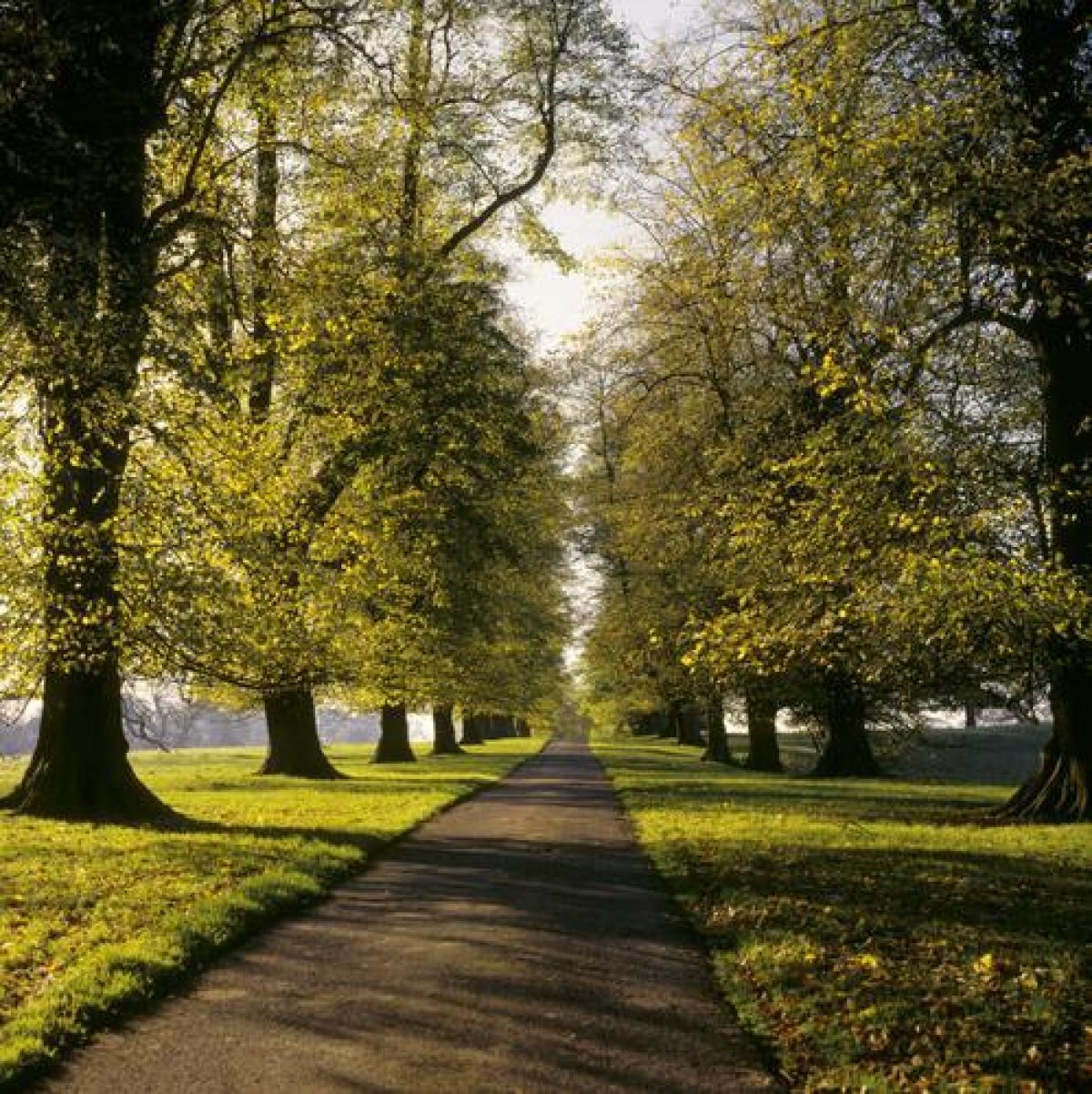
An entrance with a lodge (listed grade II) in Ticknall leads to a drive which runs south as a lime avenue planted in 1846. The drive continues past Middle Lodge (listed grade II) and runs south-east to the stables. An entrance on Heath End Lane has a lodge and gate piers (both listed grade II) from which a drive runs north-west and north to railings and gates on the south-west side of the house. The lodges were designed during the period c 1805-7 by William Wilkins.
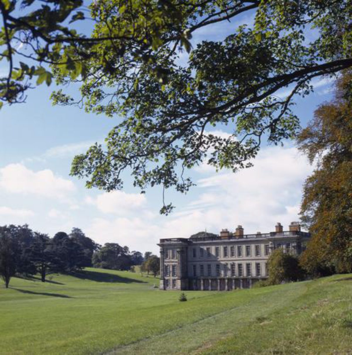
PRINCIPAL BUILDING
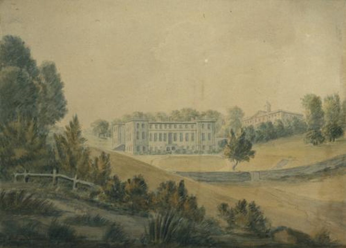
Calke Abbey (listed grade I) is a building of C16 and C17 date which was extensively remodelled in 1702-4 with alterations and additions of 1806-7 by William Wilkins and 1841-2 by Henry Stevens. It is on the site of the priory buildings and incorporates some fragments of medieval fabric. The house lies in a depression close to the centre of the park. Some 50m to the north-west the stables (William Gilkes 1712-16, listed grade II*) and riding school (mid(late C18, listed grade II*) are ranged around a courtyard; barns and ancillary buildings (early C19, listed grade II) are attached to the north. A range of other ancillary buildings (all listed grade II) including a mason's yard and a joiner's shop lie immediately to the north and east of the complex.
GARDENS AND PLEASURE GROUNDS
The south front of the house overlooks lawns which are enclosed by railings to the east and a ha-ha to the south. The land rises to the south and grass paths lead through pleasure grounds planted with a mixture of native and exotic trees and shrubs at varying stages of maturity. Paths lead south through the grounds to St Giles' church (see below) and east to the kitchen gardens. A group of mature lime trees in the pleasure grounds c 130m south-east of the house could be survivors of a short avenue shown immediately north of an orchard on the 1761 map.
On the east side of the house there are lawns and meadows enclosed by fences on the north side and a mid C19 wrought-iron deer fence with gates (listed grade II) to the east with views out over Staunton Harold Reservoir. A grotto (listed grade II) of 1809(10 by Samuel Browne lies c 120m east of the house. This domed structure, faced with tufa and panels of Coade stone, is set in a semicircular enclosure of rubble and is approached by a path winding through rockwork.
Gardens were laid out in the early C18 probably to the design of George London (d 1714), who received £2 3s for plans in 1702. A walled garden was built on the east side of the house in 1710-15 and the 1761 map shows it as a rectangular enclosure with a semicircular bow at its east end. The map also shows a square enclosure with paths radiating from a rondpoint on the slope to the south-east of the house, where the wooded pleasure grounds now lie, and this may be the 'Hanging Garden next the Greengore' mentioned in estate accounts of 1713 (quoted in Rayner et al c 1986). East of this garden the map shows an orchard screened from the house by a short avenue. Fragments of walls in the pleasure grounds c 150m south-east of the house could be parts of the wall around the orchard.
William Emes (1730-1803) prepared plans and estimates for the gardens and pleasure grounds in 1764-5 which have not survived, but estate accounts show that periods of intensive activity took place in the gardens and park in the following decade.
PARK
There is parkland on all sides of the Abbey consisting largely of open pasture land with numerous scattered and clumped mature trees. A chain of ponds runs from west to east through a wooded valley across the northern part of the park. The westernmost is Betty's Pond, dug in 1741 when it was described in estate records as 'the new Pool at Park Gate'. It is shown on the 1761 map and was subsequently enlarged. Also on the 1761 map is the adjacent Thatch House Pond which was made in 1752. Stone steps which lead up the hillside on the north side of this pond probably relate to an C18 building called Lady Catherine's Bower which survives only as foundations. The water flows over a cascade into Mere Pond which was probably created between 1800 and 1805. There is a bridge between Mere Pond and China House Pond to the east, so named for a Chinese-style summerhouse built on an island in 1746-7 which was probably demolished in the later C19. A grotto (listed grade II) on the north bank of the pond is probably also of mid C18 date and may have been erected when the pond was enlarged in 1748. It is not known when the pond was first created but it is thought to predate the others and may have medieval origins (Rayner et al c 1986). To the east Little Dogkennel Pond is mentioned in estate accounts of 1733. Two other ponds east of Little Dogkennel Pond were both submerged when the Staunton Harold Reservoir was built in 1957, and the arm of the reservoir immediately east of Little Dogkennel Pond is on the site of Big Dogkennel Pond which was created in 1779-81 and would have been visible from the east front of the house.
A line of horse chestnut trees runs along the top of the valley along the south side of Thatch House Pond and Mere Pond, and planting is marked in this position on the 1761 map. This document shows a system of avenues across the park and surrounding countryside, which were largely felled in the 1770s, though some survive in fragmentary form. An avenue aligned on the south front of the house is shown running south across fields from the garden, and another, on the same line, ran northwards from the north side of the ponds. An avenue aligned with the west side of the house split into two, one running south-west and the other north-west to Betty's Pond, where a short avenue of mature oaks survives.
The northern part of the park is thought to have been imparked in the early C17 (guidebook), with the earliest reference to it appearing in 1666. This is the area with the oldest trees as identified by the Rayner survey (c 1986), and it is marked 'The Park' on the 1761 map where it is shown as open parkland, with other parts of the present park shown as fields
A deer shelter (late C18, listed grade II*) situated c 300m south of the house was probably built soon after the park was extended to the south in the early 1770s. A sunk fence which runs south from the kitchen garden divides the deer park from land to the east.
The church of St Giles (listed grade I) lies immediately north of the pleasure grounds c 200m south of the house and is reached via a bridge over the ha-ha. It stands in a rectangular walled churchyard (walls and entrance gates listed grade II). The building was erected 1826(8 incorporating parts of a church reputedly erected by Richard Wendsley c 1575-85 (guidebook).
To the east the park is largely under arable cultivation. The home farm complex, immediately south and east of the kitchen garden, was formed when the park was expanded to the east in the 1760s taking in part of the village of Calke and outlying farms. The complex incorporates an C18 farmhouse (listed grade II) which was retained when village and other farm buildings were cleared. The northern part of the village street was taken into the park in 1779 and a new road was built to replace it along the eastern park boundary.
A finger of parkland on the north-west side of the site on each side of the drive from Ticknall is sheltered on the east side by Lodge Plantation. This area was added in 1805 when new entrance lodges and approaches were being built.
KITCHEN GARDEN
The kitchen gardens (walls and structures listed grade II) lie c 200m south-east of the house, from which they are screened by mature planting in the pleasure grounds. The gardens consist of a series of walled compartments built 1772-4 and a central building of 1777 which has an orangery lit by a glass dome overlooking the Upper Kitchen Garden to the south, with gardeners' rooms and stores on the rear (north) side.
The Upper Kitchen Garden is a grassed paddock. There are doorways in the wall on either side of the orangery. That to the west leads to a flower garden which can also be entered from a doorway in the west wall reached from a path through the pleasure grounds. There are borders on the south, east and west sides of the garden and paths encircle a central grassed area with geometric beds and a central pond which, with the paths, is shown on an estate plan of 1857 (reproduced in Rayner et al c 1986). In the north-west corner there is an auricula theatre of c 1850 in the angle of the walls. This is an open-fronted loggia housing tiered shelving used for spring and summer displays of auriculas, geraniums and other pot plants. On the south-facing wall there is an aviary and glasshouse. This garden was enlarged to the south during the mid C19 and its internal layout restored in the late C20.
The door on the east side of the orangery leads to a courtyard north of the building enclosed by curved walls which continue northwards forming the east side of the flower garden and the west side of the Physic Garden with a path between. The walls terminate at the north end of the garden with a pair of brick gate piers. The Physic Garden is entered from a doorway in the west wall and has a stove house built in 1785 and an early C19 vinery along the inner north wall. There are a number of pits and frames in the north-west corner of the garden. The eastern half of the garden is grassland with scattered fruit trees.
To the north of the flower and Physic gardens tall gate piers flank an entrance leading into a narrow strip of land divided from the pleasure grounds by a low stone wall. Ancillary buildings are ranged along the outer (north) face of the Physic Garden wall. Set against the outer, northernmost wall, c 60m north of the orangery, there is an entrance leading to a tunnel which runs north for a distance of c 70m beneath the pleasure grounds and into the park. This was built in 1816 so that garden staff did not have to enter the pleasure grounds.
The outer west wall of the flower garden and parts of the outer north wall of the Upper Kitchen Garden are of roughly worked stone in contrast to the brickwork of other walls. It is possible that these walls were the east and south walls of the orchard marked on the 1761 map.
REFERENCES
N Pevsner and E Williamson, The Buildings of England: Derbyshire (2nd edn 1978), pp 119-120
Country Life, 174 (20 October 1983), pp 1062-1065; (27 October 1983), pp 1162-1165; (5 November 1983), pp 1242-1245
H Rayner, P Heath and S Hancock, Calke Abbey: Vol 1, Park and Garden Development; Vol 2, Park and Garden Survey, (survey for National Trust c 1986)
Calke Abbey, guidebook, (National Trust 1989)
Maps
(reproduced in Rayner et al c 1986)
S Wyatt, Estate map, 1761
Estate plan, 1857
OS 6" to 1 mile: 1924 edition
Description written: July 1998
Amended: March 1999
Edited: November 1999
- Visitor Access, Directions & Contacts
Telephone
441332863822Access contact details
http://www.nationaltrust.org.uk/place-pages/61/pages/opening-times-calendar
Owners
National Trust
PO Box 39, Warrington, WA5 7WD
- History
Calke Abbey was originally an Augustinian priory founded in the early 12th century. By the mid-12th century religious activity at the site was reduced to serving as a cell to the nearby priory at Repton. The site was then taken by the state during the dissolution of the monasteries in the 16th century.
The original Elizabethan manor house was completely remodelled from 1701 to 1704 so that nothing remains of the original house. William Emes designed the park and pleasure grounds in 1776.
The National Trust took on the house in 1985 and began a programme of restoration.
The following is from the Register of Parks and Gardens of Special Historic Interest. For the most up-to-date Register entry, please visit the The National Heritage List for England (NHLE):
www.historicengland.org.uk/listing/the-list
HISTORIC DEVELOPMENT
An Augustinian priory was founded on the site between 1115 and 1120. By 1172 the canons had moved to Repton and Calke was subsequently a dependency of Repton. Following the Dissolution Calke was granted to the Earl of Warwick and after several changes of ownership it was sold to Henry Harpur (baronet from 1626) in 1622. In 1761 a map of the gardens and estate was drawn up by Samuel Wyatt for Sir Harry Harpur shortly after he came of age. The site remained in the family until 1985 when Henry Harpur-Crewe gave it to the National Trust in whose ownership it remains (1998).
Period
18th Century (1701 to 1800)
- Associated People
- Features & Designations
Designations
The National Heritage List for England: Register of Parks and Gardens
- Reference: GD1667
- Grade: II*
Nature Reserve
Features
- Lake
- Great House (featured building)
- Description: The original Elizabethan manor house was completely remodelled in the early 18th century.
- Earliest Date:
- Latest Date:
- Icehouse
- Kitchen Garden
- Specimen Tree
- Description: An oak tree in the park which is about 1000 years old.
- Orangery
- Walled Garden
- Hall
- Key Information
Type
Estate
Purpose
Ornamental
Principal Building
Heritage Site
Period
18th Century (1701 to 1800)
Survival
Extant
Hectares
210
Open to the public
Yes
Civil Parish
Calke
- References
References
- {English Heritage Register of Parks and Gardens of Special Historic Interest} (Swindon: English Heritage 2008) [on CD-ROM] Historic England Register of Parks and Gardens of Special Historic Interest
- Pevsner, N and Williamson, E {The Buildings of England: Derbyshire} (Harmondsworth: Penguin, 1978) pp 199-120 The Buildings of England: Derbyshire
- Rayner, H {Park and garden development: park and garden survey} (1988) Park and garden development: park and garden survey
- Gardens Survey Team, National Trust {The park and gardens at Calke Abbey} (1988) The park and gardens at Calke Abbey
- Related Documents
-
CLS 1/983/1
Parkland Plan Vol.1 - Hard Copy
Hilary Taylor Landscape Associates Ltd - 2012
-
CLS 1/983/2
Parkland Plan Vol.2 - Hard Copy
Hilary Taylor Landscape Associates Ltd - 2012
-
CLS 1/983/3
Parkland Plan Vol.3 - Hard Copy
Hilary Taylor Landscape Associates Ltd - 2012
-
CLS 1/983/1