Introduction
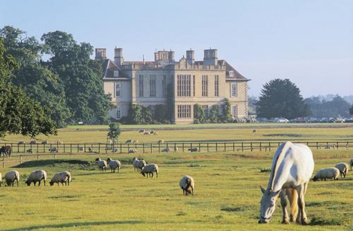
Stapleford Hall has a 17th-century deer park landscaped in the 18th century and later modified by Lancelot Brown, which at its most extensive was 325 hectares. The gardens immediate to the hall contain several walled gardens, lawns and ornamental borders. Stapleford Hall is now used as a hotel and country retreat.
Terrain
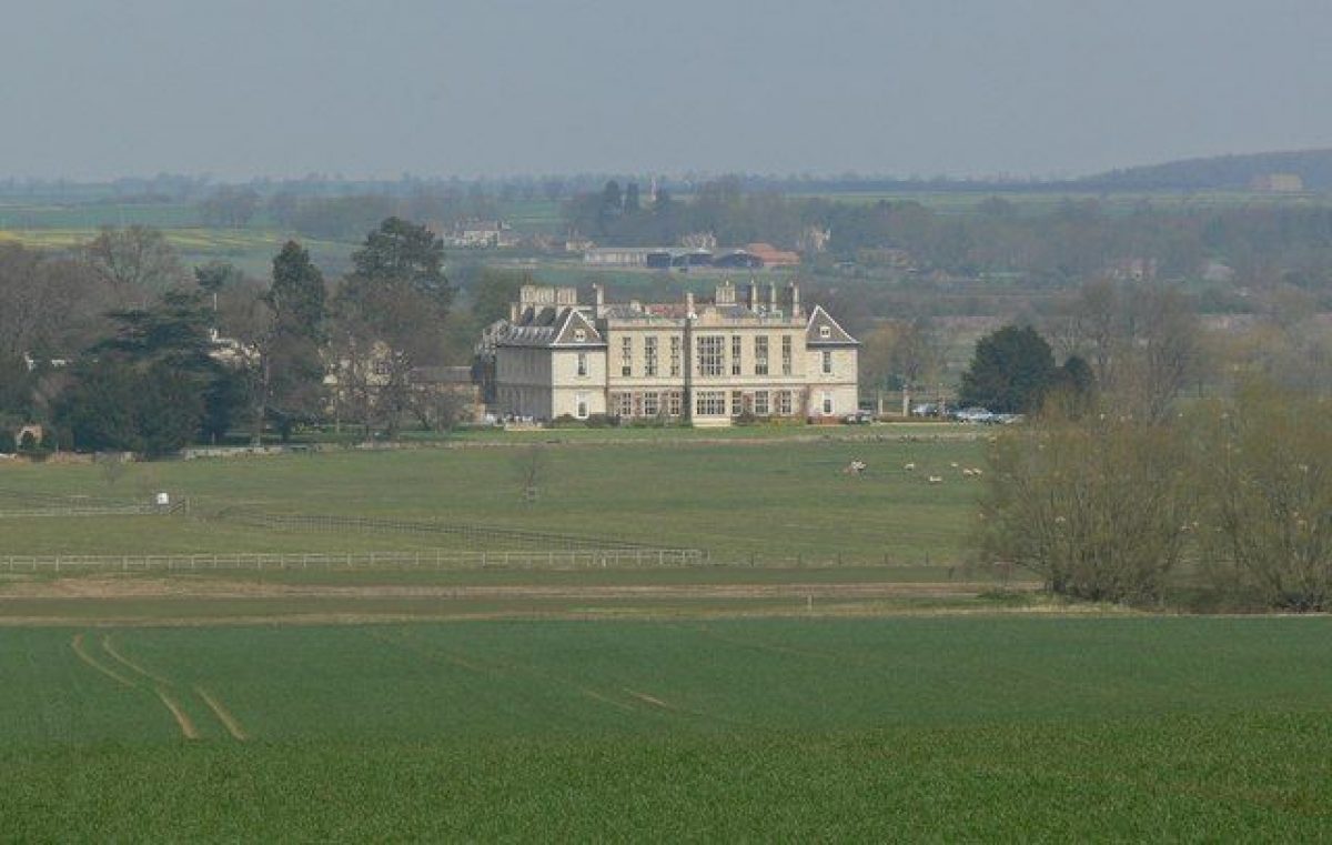
The shallow valley of the River Eye is overlooked from the hall to the west. The hall also has views south over gently falling ground.www.historicengland.org.uk/listing/the-list
Gardens, grounds and a landscape park, the last modified in 1770s probably to a scheme devised by Lancelot Brown, associated with a country house.
DESCRIPTION
LOCATION, AREA, BOUNDARIES, LANDFORM, SETTING
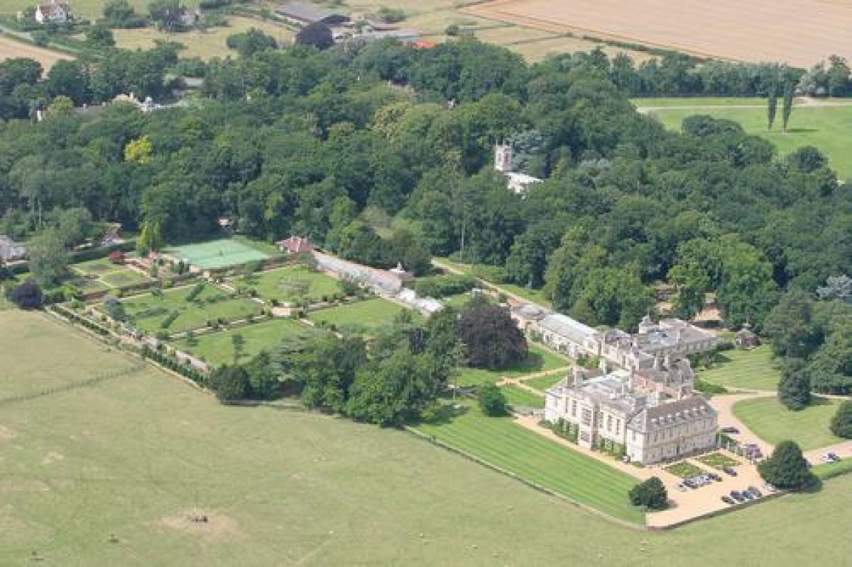
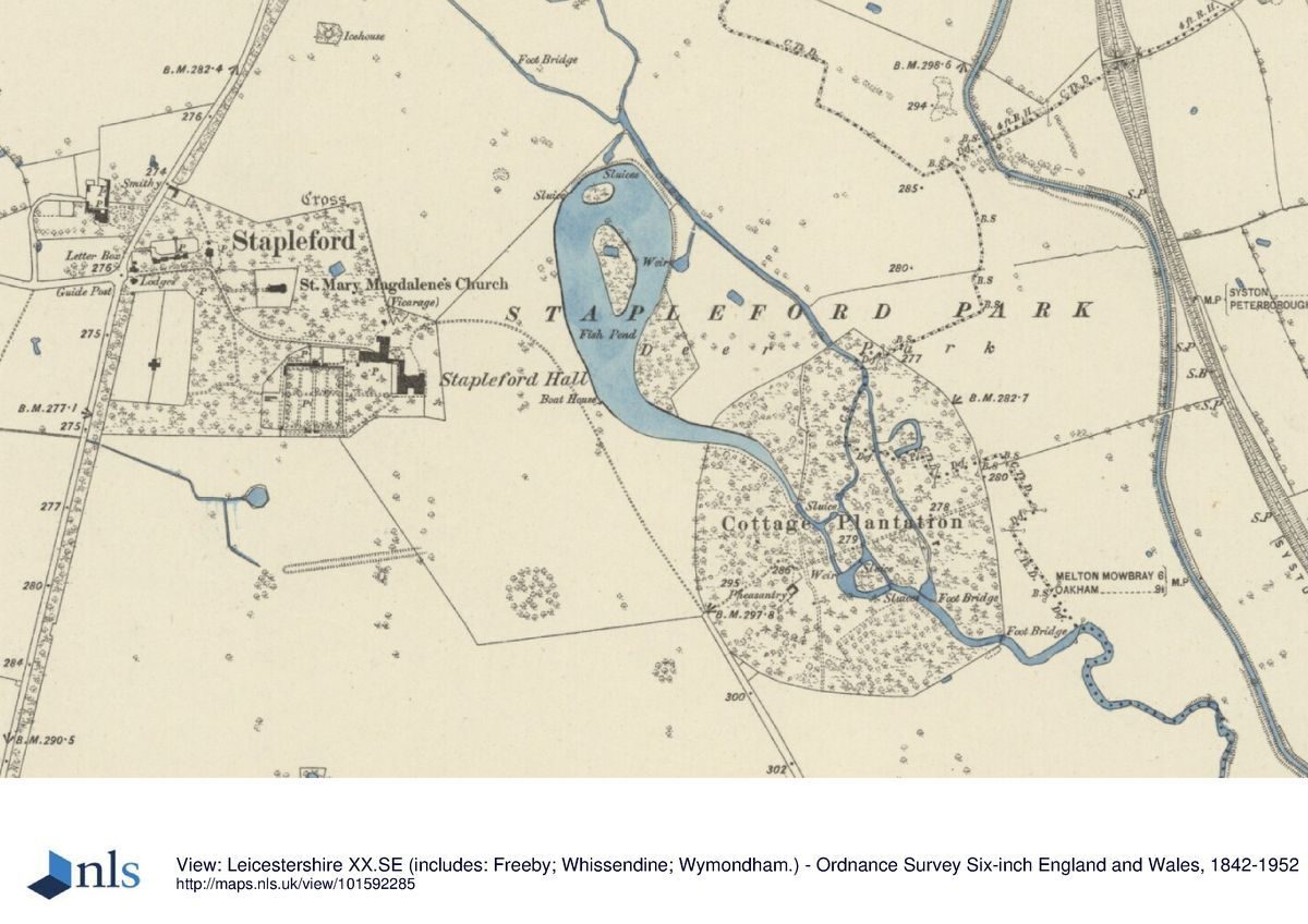
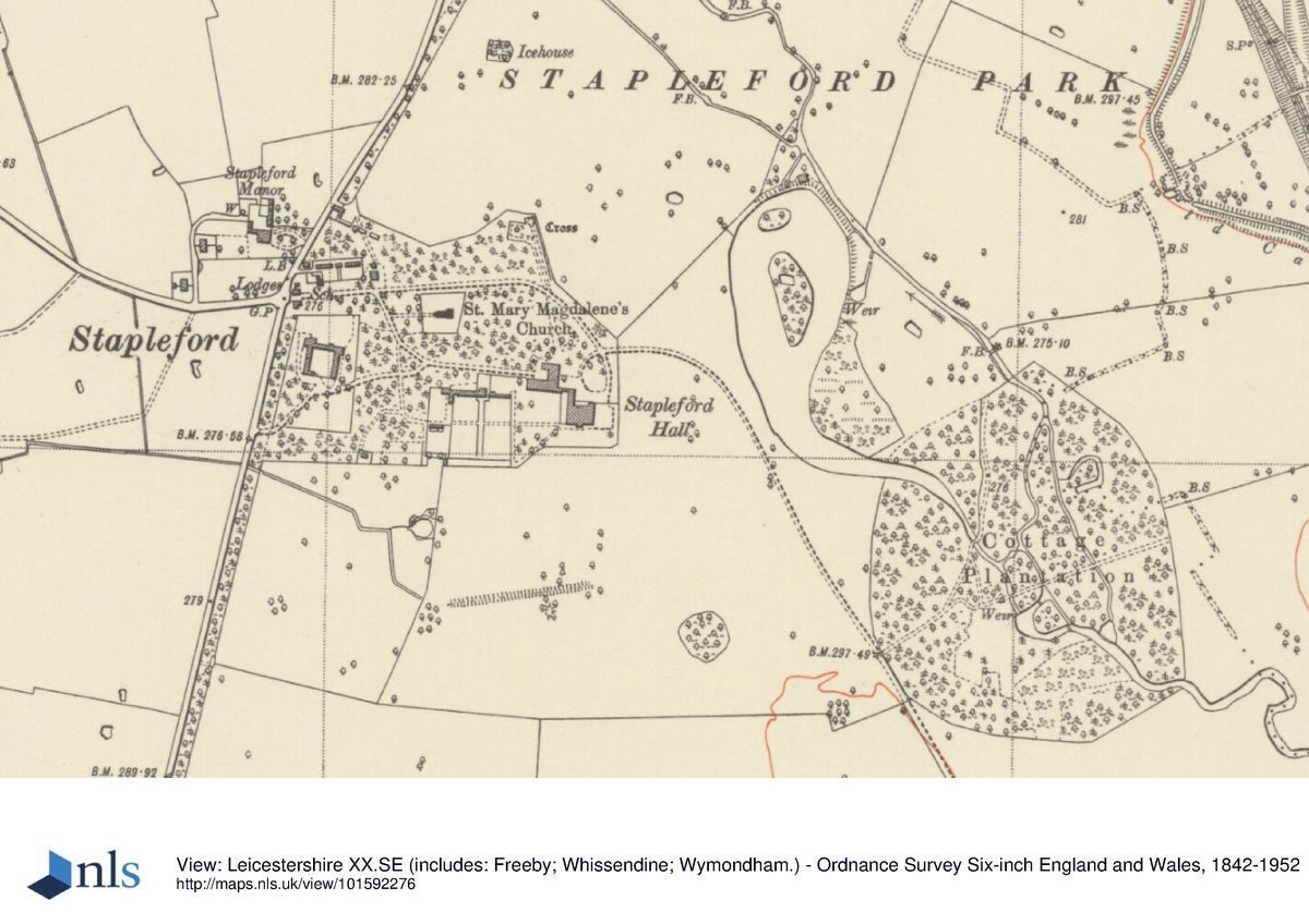
Stapleford Hall stands within its park 5km east of Melton Mowbray. Although there is no longer a village at Stapleford the Hall is used as a hotel and various estate cottages for staff accommodation, while St Mary Magdalene?s church stands within the grounds. Minor local roads run around the west and south sides of the park, the third, easterly, boundary following the railway. The park is crossed from south-east to north-west by the River Eye, the shallow valley of which is overlooked from the Hall to the west, which also has views south over gently falling ground. The area here registered is c 300ha.
ENTRANCES AND APPROACHES
The main entrance to Stapleford, with later C19 gates and piers (listed grade II), is on the centre of the west side of the park, flanked by a pair of ornate, low, earlier C19, cottage-style ironstone lodges with ashlar details (listed grade II). From here drives run east through ornamental woodland, the main one ending at a gravelled forecourt on the east side of the Hall. On the north side of the forecourt are late C19 gates and screen on ashlar piers (listed grade II). Still surviving as a track is a drive of the 1770s from Holygate Lodge (listed grade II), an ornate, two-storey, stone, earlier C19 building midway along the south side of the park boundary, close to which are a deer slaughterhouse, an octagonal venison larder and a pair of privies (all earlier C19 and listed grade II).
PRINCIPAL BUILDING
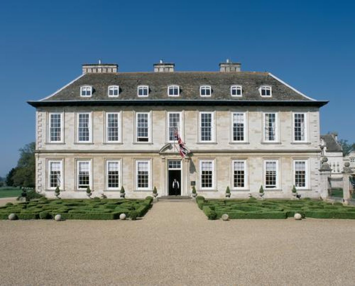
Stapleford Hall (listed grade I) is a largely ashlar building, its main fronts to the east and south. The north wing, of c 1500, was remodelled in 1633 with decorative embellishments celebrating the pedigree of the Sherards and their matches. The two-storey, hip-roofed, main block is of c 1670. The south facade was Jacobeanized in 1894-8 by Micklethwaite, who also added the large block between the projecting wings and a north, service, wing incorporating a gateway of c 1630. Twenty metres north of that is an octagonal venison larger of 1820 (listed grade II).
On the edge of the park, 400m west of the Hall, are the stables (listed grade II*). Ranged around a courtyard, and in stone in the Jacobean style, these were built in 1899 to a design by Peter Dollar. Pevsner (1984) thought them perhaps Leicestershire?s finest.
St Mary Magdalene's church (listed grade I), an ashlar building with west tower in the Gothick style, stands 200m north-west of the Hall. It is of 1783, and was designed by George Richardson (d c 1813).
GARDENS AND PLEASURE GROUNDS
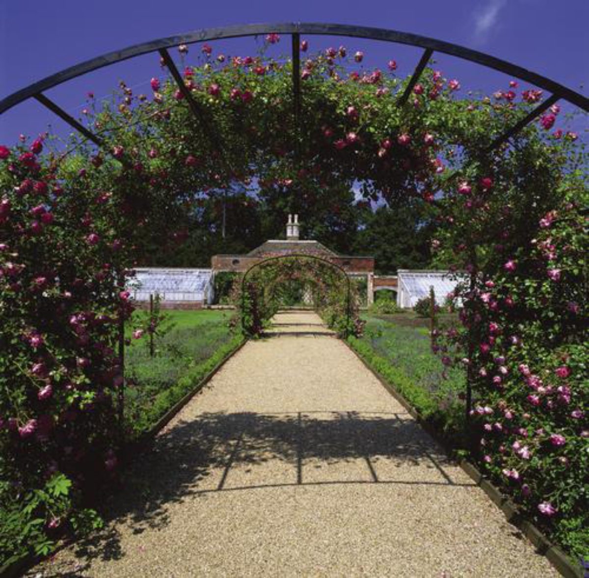
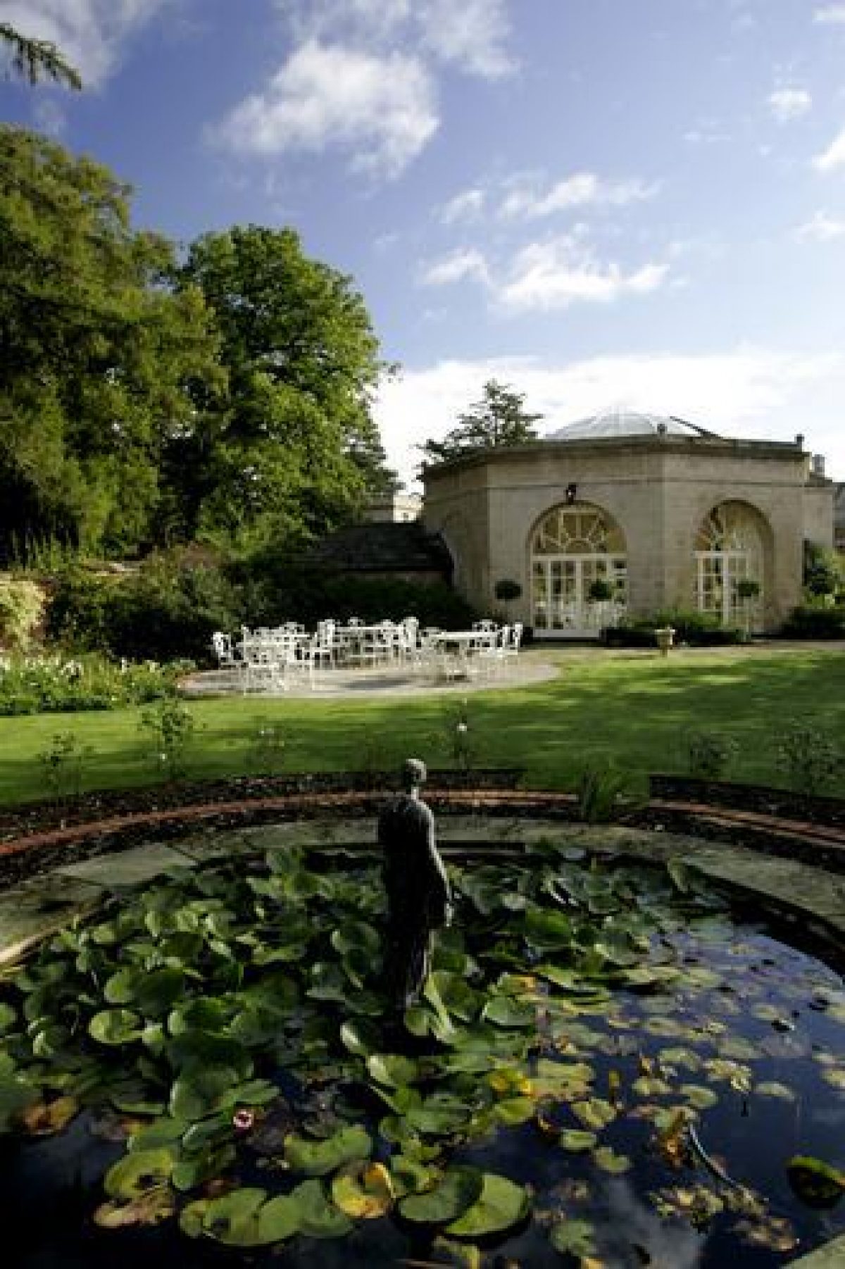
A straight C19 ha-ha (listed grade II) runs c 75m south and east of the Hall, its line being continued west and north around the extensive, early C19, ornamental woodland which extends to the west edge of the park and surrounds and partly conceals the stables, church and other estate buildings from the approach drives through it. East of the Hall are small, box-edged parterres of the 1990s and a gravelled forecourt, and to the south and north formal lawns with trees and shrubs on their fringes. The main view is to the south; that to the east, across the lake, is less successful (at least at ground level), as the ground falls only a little. There is also a lawn west of the Hall, between it and the kitchen garden; on its western side are several mature specimen trees and a yew grove.
There is little documentary evidence for the form of the formal gardens which accompanied the Hall between c 1630 and Brown's landscaping of the 1770s which is assumed to have swept them away. Archaeological evidence (Liddle and Hartley 1996) indicates one or more parterres extending c 75m east of the eastern ha-ha. A few trees remain of a horse chestnut avenue, perhaps of c 1710, which ran between the east side of the gardens and, perhaps, the River Eye, continuing the line of the main axis past the north side of the Hall. Whether formal gardens also extended south of the Hall is unclear. The earthwork of a broad east/west ditch-like feature 200m south of the south ha-ha has been interpreted (ibid) as a garden feature, although there is ridge and furrow to the north of it and a drainage function seems more probable.
PARK
The Hall stands towards the west side of a triangular park, 2.3km in diameter both north to south and east to west. To west and south, where bounded by public roads, there is a shelter belt. Around the Hall, extending for c 400m to the River Eye and for about the same distance to the south, is permanent pasture. There is some well-preserved ridge and furrow, while north and south of the Hall?s grounds are the extensive earthworks of Stapleford village (scheduled ancient monument), the site of which may also extend beneath the woodland west of the Hall. South of the ornamental woodland around the Hall, abutting the western edge of the park, a three-hole Golf Academy was opened in the mid 1990s. Otherwise, apart from woodland, the park is largely under arable cultivation. At its northern tip is an extensive Anglo-Saxon cemetery.
Three hundred metres east of the Hall the River Eye has been dammed to form a 300m long oval lake with serpentine tail to the south, in the centre of which is a large wooded island. The serpentine tail extends into the Cottage Plantation, circular, 400m in diameter, and with woodland walks. This was planted between 1818 and 1824. The landscaping of the 1770s and later also included the planting of clumps; a cohesive circular example survives 300m south-east of the Hall, together with less compact examples and large numbers of mature, individual trees, mostly oak. Further planting took place after the Grettons purchased Stapleford in the 1890s, and the many small clumps of oak, Turkey oak, beech, lime and red horse chestnut date from this time.
Some 700m north of the Hall the Saxby road along the park edge crosses the Eye Bridge, a brick structure of 1773. About 50m north-east is the former estate mill (mid C19, listed grade II), now a house, while 50m south of the bridge are eight almshouses (listed grade II) of 1732, enlarged in the Picturesque style in 1820. Shepherd's Cottage (listed grade II), a mid C19 estate cottage, lies at the south-west corner of the park.
The park is first mentioned in 1640, when it had a lodge and contained eighty deer. It was presumably created in the 1630s when the Hall was remodelled. In 1775 Lancelot Brown was paid £31.10s for a visit to Stapleford. Although no plan or other documentation survives, the visit almost certainly produced a scheme for landscaping, planting and the serpentine lake, the construction of which was supervised by William Ireland, one of Brown's foremen. The work was apparently substantially complete by 1777, although at that date the park remained very confined, barely extending west or north of the Hall and only a little to the south. The final enclosure of Stapleford?s three fields took place in 1772, and farmhouses began to be built out in the new, enclosed, fields; Stapleford village, in the Middle Ages a large settlement, may have seen further contraction. In 1818 local roads were closed and the park tripled in size, a further major enlargement before 1834 effectively creating the park as here registered. At first the eastern boundary of the enlarged park was the canal, later the railway.
KITCHEN GARDEN
Some 100m west of the Hall are the brick-walled former kitchen gardens, the main c 100m square compartment perhaps of c 1670. Along its north side is a lean-to glasshouse with raised central section, built against the back wall of which is the early C19 stone gardener's cottage. There is a walk with herbaceous border along the outside of the south wall of the garden, with a pergola giving views southward across the park. To the west of the main garden is another garden compartment, on the north side of which is another gardener's house. The kitchen gardens were converted to pleasure gardens and fruit grounds after the Hall became a hotel.
REFERENCES
N Pevsner, E Williamson and G K Brandwood, The Buildings of England: Leicestershire and Rutland (1984), pp 386-9
P Liddle and R F Hartley, The Development of Stapleford Park, Leicestershire (Leicestershire Museums 1996)
L Cantor and A Squires, The Historic Parks and Gardens of Leicestershire and Rutland (1997), p 34
C Gallagher, Stapleford Park: A Survey of the Landscape (1998)
Maps OS 6" to 1 mile:
Leicestershire sheet 20 NE, 1st edition published 1881
Leicestershire sheet 20 NE, 2nd edition published 1904
Leicestershire sheet 20 SE, 1st edition published 1889
Leicestershire sheet 20 SE, 2nd edition published 1904
Leicestershire sheet 20 NE, 1931 edition
OS 25" to 1 mile: Leicestershire sheet 20.12, 2nd edition published 1904
Description written: July 1998 Amended: May 1999
Register Inspector: PAS
Edited: July 1999
- Visitor Access, Directions & Contacts
- History
The following is from the Register of Parks and Gardens of Special Historic Interest. For the most up-to-date Register entry, please visit the The National Heritage List for England (NHLE):
www.historicengland.org.uk/listing/the-list
HISTORIC DEVELOPMENT
Before the mid C16 Stapleford's two manors had been reunited by the Sherards. William Sherard was knighted in 1622 and was created Lord Sherard and granted the Irish peerage of Baron of Leitrim in 1627. It was under him that the Hall was rebuilt and, almost certainly, the park created. The Hall was greatly enlarged c 1670 by his son Benet Sherard. His son, also Benet, was created Baron of Harborough, and in 1719 Earl of Harborough. The second Earl, Philip, succeeded in 1732; the third, Benet, in 1759; the fourth, Robert, who commissioned Lancelot Brown (1716-83) to devise a scheme to landscape the park, modified the Hall and rebuilt the church, in 1770; the fifth, Philip, in 1799; and the sixth and last, Robert (d 1859), in 1807. It was in the time of the sixth Earl, between c 1818 and 1834, that the park was enlarged to its present size, most of its ornamental woodland planted and many of the lodges and other estate buildings constructed. The sixth Earl was survived by his wife who lived on until 1886. Stapleford was then sold to James Hornsby, who in 1894 sold it to John Gretton who carried out much alteration and new building. His son, who inherited in 1899 and later became Lord Gretton, remained at Stapleford until the 1980s. The Hall is today a hotel, whose owners also own or lease the adjacent parkland. The greater part of the registered park remains (1998) in private hands.
Period
- 18th Century (1701 to 1800)
- Late 18th Century (1767 to 1800)
- Associated People
- Features & Designations
Designations
The National Heritage List for England: Register of Parks and Gardens
- Reference: GD1964
- Grade: II
Features
- Lawn
- Croquet Lawn
- Bed
- Border
- House (featured building)
- Description: The house was built in the ealy-17th century, and greatly enlarged in 1670. It has since been altered.
- Earliest Date:
- Latest Date:
- Deer Park
- Walled Garden
- Hotel
- Key Information
Type
Park
Purpose
Ornamental
Principal Building
Commercial
Period
18th Century (1701 to 1800)
Survival
Extant
Hectares
300
Open to the public
Yes
Civil Parish
Freeby
- References
References
- {English Heritage Register of Parks and Gardens of Special Historic Interest}, (Swindon: English Heritage, 2008) [on CD-ROM] Historic England Register of Parks and Gardens of Special Historic Interest
- Pevsner, N., {The Buildings of England: Leicestershire and Rutland} (Harmondsworth; Penguin, 1984). pp. 386-8 The Buildings of England: Leicestershire and Rutland
- Cantor, L. and A. Squires, {The Historic Parks and Gardens of Leicestershire and Rutland} (Newtown Linford: Kairos Press, 1997), p. 34 The Historic Parks and Gardens of Leicestershire and Rutland