Introduction
Burley on the Hill has the remains of 17th- and 18th-century formal landscaping around the house and in the parkland and woodland, including a 17th-century avenue and bowling green. Humphry Repton produced a Red Book for the estate in the late 18th century. The site is now in multiple private ownership and the house has been converted to apartments.
Terrain
Burley House lies 500 metres south of the village, on the crest of a hill which drops sharply away to the west and south.The following is from the Register of Parks and Gardens of Special Historic Interest. For the most up-to-date Register entry, please visit the The National Heritage List for England (NHLE):
www.historicengland.org.uk/listing/the-list
Formal, terraced gardens of 17th- and early 18th-century date modified by Humphry Repton in about 1796, and a landscape park associated with a country house.
Location, Area, Boundaries, Landform and Setting
The park lies south of Burley village, 5km north-east of Oakham. Burley House lies 500m south of the village, on the crest of a hill which drops sharply away to the west and south. To the north-west the park is bounded by the B668 Cottesmore Road and to the north-east, where the park has a low stone wall, by Exton Lane. The south edge of the park now largely follows the A606, a modern road built along the north shore of Rutland Water, to replace an earlier line 500m to the south lost when the reservoir was created in the mid C20. The area here registered is c 300ha.
Entrances and Approaches
There are two approaches from the north. Church Road, lined with mature trees, runs 400m south from Burley village to its church; it runs down the west side of the Burley House complex. In the 1990s a new drive was made to the House from a gateway on Cottesmore Road c 300m north-east of Burley village.
Elements of the C18 avenue approaches from the east and south remain. Some 400m of the east avenue survives east of the House, continuing the terrace axis. The drive from this to the East Lodge with its stone archway (listed grade II*) on the park boundary 1km to the east no longer survives.
A round-arched gate on the Stamford Road (the old A606), south of an arm leading west from Burley Reach (the name attached to that part of Rutland Water south of Burley Wood) is early C17 (listed grade II); it lies directly on the line of the southern avenue.
Principal Building
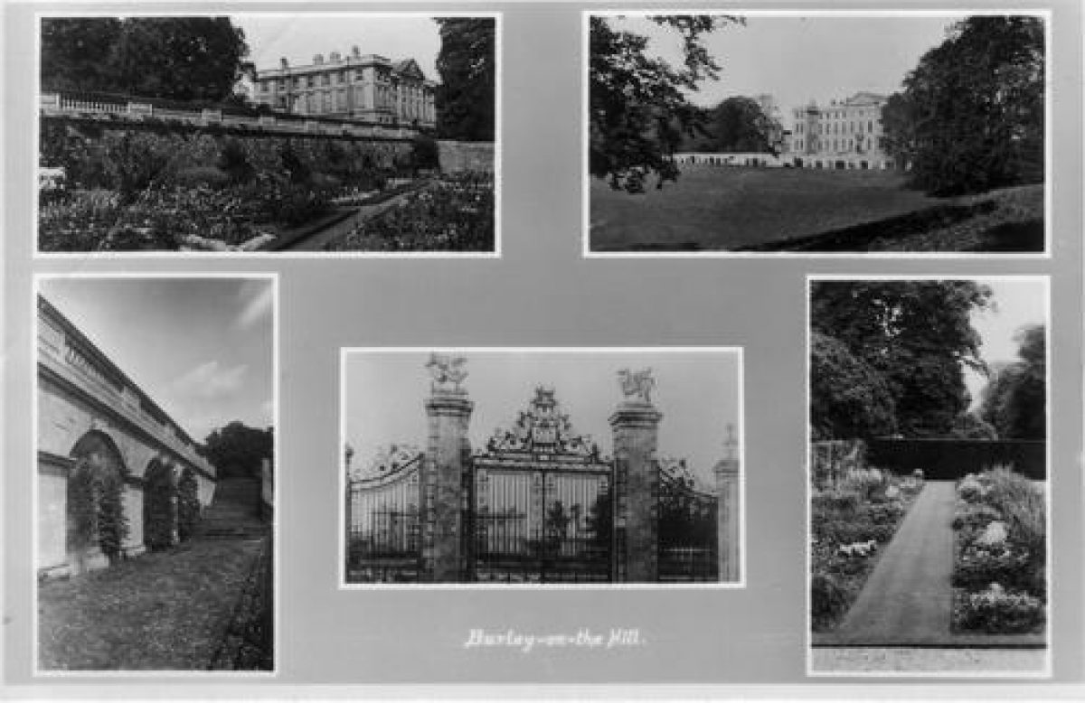
Burley House (listed grade I) was rebuilt on the site of the C17 mansion destroyed in the Civil War between 1694 and 1700 for the second Earl of Nottingham, who had travelled in France and Italy in the 1660s and may have been his own architect. It is of Clipsham stone, and although it faces south across its park the approach is to the dramatic north side. This comprises a main four-storey block fifteen bays by seven, with central three-bay pediment and slightly projecting two-bay wings. Short, columned quadrant blocks link this to low, seven-bay offices, off which longer and wider quadrant galleries run to outer thirteen-bay stable ranges, that to the east surviving from the C17 house.
Overall the style, of what Pevsner (1960) calls a palace, is Palladian, although the House predates by some twenty years the accepted start of the Palladian Revival. At first work was supervised Henry Dormer (d 1727); in 1697 he was replaced by John Lumley (d 1721), who was still working there on the stables in 1705.
Burley church (listed grade II*) lies 50m west of the west side of the House, and forms an important element of the overall architectural composition.
Gardens and Pleasure Grounds
The great forecourt on the north side of the House, 213m deep from north to south, is grassed, with a drive around the edge. An iron screen with paired entrance gates and gate piers, with flanking pedestrian gates and outer piers of 1700 with ironwork by Josiah Lord (all listed grade II*) runs across the north side of the forecourt. The gates were originally flanked with lodges and walling, swept away in 1795 although not necessarily to Repton's instructions. He however was probably responsible for reinstating the railings on the same line as a divide between the forecourt and the park beyond, and for the line of the drives around the forecourt rather than directly across it.
A 256m long, 30m wide terrace extends along the south front. A low, stone, balustraded parapet (listed grade II*) stands above a 4m high retaining wall containing shallow arched recesses. Two symmetrical flights of steps with stone balustrades with a sweeping stone rail rise to the central projecting section of the terrace. This represents Repton?s adaptation of three tiered terraces constructed c 1700, at the bottom of which was a vast semicircular apron containing a parterre. From a distance the terraces formed an important visual base for the building. The terraces of c 1700 were adapted from a flight of three below the C17 house. A plan of c 1680 shows a bowling green and mount west of the topmost of these. At the base of the C17 terraces was a well, beyond which was the central avenue of a patte d'oie.
Park
The House stands near the north-west edge of a roughly circular park c 2km in diameter. North of the House is permanent pasture with a ring of parkland trees looping around its northern side. East of this the north half of the parkland is farmland, mostly arable. Home Farm (listed grade II), built c 1795 by John Nash (1752-1835) for the ninth Earl and extended c 1840, stands on the Cottesmore Road c 750m north-east of the House. Within the one large area of woodland, Crow Spinney, there is a moated site.
The southern half of the park, sloping down to Burley Reach, is dense woodland, Burley Wood. Much of this is coniferous plantations. This is cut through with rides and tracks, notably a radiating arrangement in the east half of the wood centred on Eight Riding Tree, and running south from the House on the line of the C17 south avenue. That avenue continues for 300m south of the A6006 before being truncated by an arm of Burley Reach. A small continuation of the registered area south of the water picks up the line of the avenue. Three hundred metres north of the A606 is one triangular fishpond and traces of others, part of a large fishpond and canal complex present by the early C18.
There was a park at Burley in Norman times; its boundary may be largely conterminous with the later landscape park. The park was improved by the Duke of Buckingham in the 1620s; large numbers of fir trees were planted, probably under the supervision of John Tradescant the elder (d 1638), and the complex arrangement of avenues shown on later maps and illustrations was laid out. By the end of the C17 the village of Burley had largely been removed, although a few houses still stood immediately north of the north court. After the depredations of the Civil War, work on the geometric layout began again c 1690 and was completed by 1724. This was shown on a painting by Tillemans c 1729 (Harris 1979). It was during this phase of work that a great rectangular fishpond, aligned east/west and 650m long, was laid out across the line of the south avenue c 200m north of the gateway on the Stamford Road. The pond now lies beneath the arm of water leading west from Burley Reach.
Repton was much impressed by Burley's situation and its park. He recommended removing the approach through it from the south. In 1807 the Sanctuary of the Hermit Finch, a thatched gothick folly, was built 800m south-east of the House. It burnt down in 1965.
A small deer park was created immediately south of the gardens in the late C20.
Kitchen Garden
In the C18 and later a brick-walled kitchen garden lay 200m north-west of the House and down slope of it. A crinkle-crankle wall forms the north side. A house was built within the interior in the 1990s and gardens laid out around it.
In the early C18 a melon ground lay west of the terraces. Its site was later occupied by a second, smaller, kitchen or fruit garden.
REFERENCES Used by English Heritage
J Horticulture & Cottage Gardener 51, (11 June 1874), pp 468-70
Country Life, 7 (24 February 1900), pp 240-4
P Finch, History of Burley-on-the-Hill (1901)
N Pevsner, The Buildings of England: Leicestershire and Rutland (1960), pp 288-91
J Harris, The Artist and the Country House (1979), p 233
P L Ross, The John Tradescants (1984), p 76
M O'Hagan, Report on Evolution of the Park at Burley-on-the-Hill, Rutland (1989)
C Thacker, The Genius of Gardening (1994), pp 125, 130
L Cantor and A Squires, The Historic Parks and Gardens of Leicestershire and Rutland (1997), p 41
Maps
Plan of Burley on the Hill, around 1680 (reproduced in Ross 1984, p 76)
Plan of Burley on the Hill, 1783 (reproduced in Finch 1901)
OS 6" to 1 mile: 1st edition surveyed 1884, published 1889; 2nd edition surveyed 1902, published 1905; 3rd edition surveyed 1928, published 1931
OS 25" to 1 mile: 1st edition surveyed 1884, published 1885
Archival items
Humphry Repton, Red Book for Burley (private collection)
The estate and family papers used by Finch were destroyed in a great fire of 1908 although Leicestershire Record Office has several plans and surveys.
Description written: August 1998
Edited: June 1999
- Visitor Access, Directions & Contacts
- History
The following is from the Register of Parks and Gardens of Special Historic Interest. For the most up-to-date Register entry, please visit the The National Heritage List for England (NHLE):
www.historicengland.org.uk/listing/the-list
HISTORIC DEVELOPMENT
Sir John Harrington, later Lord Harrington, sold Burley on the Hill to George Villiers, first Duke of Buckingham. Between 1620 and his assassination in 1628 Buckingham built a new house next to the church on the summit of a commanding hill and improved the park to the south and east. The property passed to his son, but in 1644 the house was almost burnt to the ground by Roundheads. In 1694 the estate was sold to the Secretary of State to William III, Daniel Finch, second Earl of Nottingham and, in 1729, seventh Earl of Winchelsea. In 1674 he married Lady Essex Riche and in 1685, after her death, Anne Hatton, the daughter of the second Lord Hatton of Kirby Hall, Northamptonshire (see description of this site elsewhere in the Register). On the death of the seventh Earl, Burley passed to his son Daniel, the eighth Earl (died 1769), who was succeeded by his nephew George, the ninth Earl. In 1795 the ninth Earl called in Humphry Repton (1752-1818) to modernise the house's surrounds, and he produced a Red Book. House and grounds were divided into multiple private ownership in the late 20th century.
- Associated People
- Features & Designations
Designations
The National Heritage List for England: Register of Parks and Gardens
- Reference: GD1338
- Grade: II
Features
- Bowling Green
- Tree Avenue
- House
- Parkland
- Woodland
- Flats
- Key Information
Type
Estate
Principal Building
Domestic / Residential
Survival
Extant
Hectares
300
Civil Parish
Burley
- References
References
- {English Heritage Register of Parks and Gardens of Special Historic Interest}, (Swindon: English Heritage, 2008) [on CD-ROM] Historic England Register of Parks and Gardens of Special Historic Interest
- Pevsner, N., {The Buildings of England: Leicestershire and Rutland} (Harmondsworth; Penguin, 1984) The Buildings of England: Leicestershire and Rutland
- Harris, J., {The Artist and the Country House} (London: Russell Chambers, 1979), p. 233 The Artist and the Country House
- Related Documents
-
CLS 1/144/2
The Wilderness Garden at Burley-on the -Hill, Rutland - Hard copy
Arcturus (Todd Longstaffe-Gowan) - 1989
-
CLS 1/144/1
Report on the Evolution of the Park at Burley-on-the-Hill, Rutland c1086 - 1884 - Hard copy
Arcturus (Mary O'Hagan) - 1989
-
CLS 1/144/2