Introduction
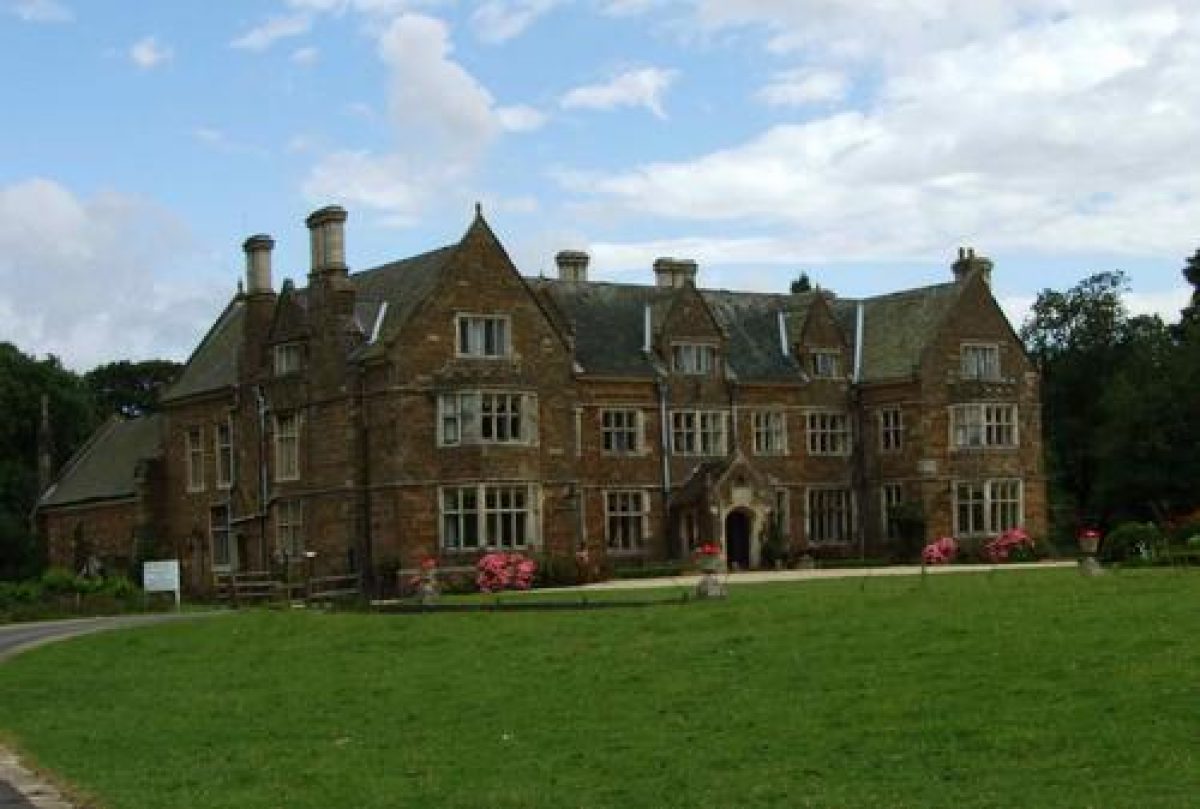
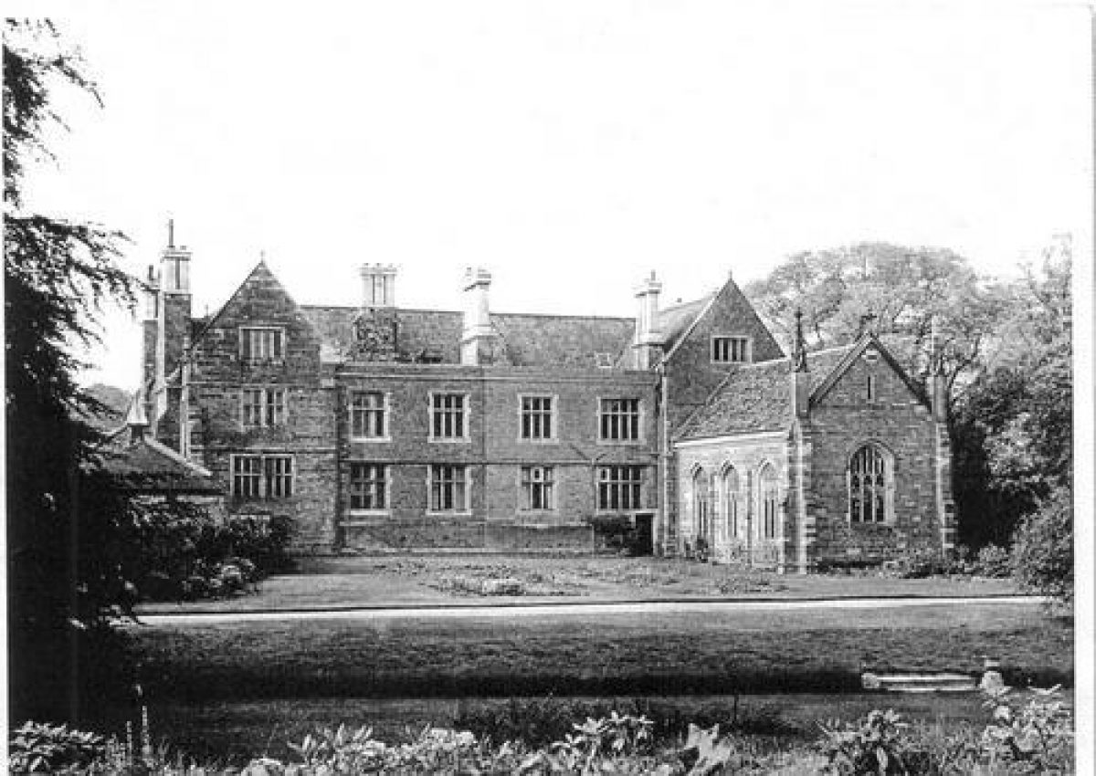
Launde Abbey is a substantial country house in east Leicestershire. It is surrounded by attractive landscaped gardens and parkland containing mature trees. There is an 18th-century stable block, a chapel, and an early 19th-century ha-ha, walled garden and glasshouse.
Terrain
Launde Abbey is set in a valley- Visitor Access, Directions & Contacts
Telephone
01572 717254Website
https://www.laundeabbey.org.ukDirections
Because of its rural location, Launde Abbey is best accessed by road. It is 14 miles east of Leicester, off the A47. It is signposted from the village of East Norton (just off the A47). Follow the signs to Launde, turning right in Loddington. After about one mile, cross the cattle grid and Launde Abbey is on the right.
Owners
Launde Abbey Trust
Church House, St. Martins East, Leicester, LE1 5FX
- History
Richard and Maud Basset founded the Augustinian Priory of St. John the Baptist in an area which was a minor Royal forest. According to Pevsner, this occurred between 1119 and 1125. The name ‘Launde’ is Old French for ‘glade’ or ‘pasture’ and indicates a clearing in the woods.
The landscape at Launde was a complicated one – reflecting the economic structure at the time. It was a minor royal forest. In 1235, the Abbot requested permission to create a deer park, as the forest was contracting in size. In 1248 permission was awarded and the forest continued as a park until the dissolution of the monasteries in the early 16th century.
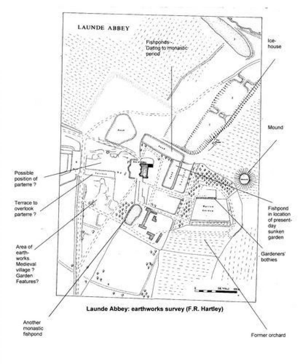
Park Wood was the site of the park, which extended to West Wood. This remained virtually unchanged for centuries. Earthwork banks to the west, north and south of the house may be associated with the medieval deer park. Some fishponds and a water ‘tank’ at the top of the hill above the priory date from the medieval period.
In the period prior to the Dissolution, there is evidence that Thomas Cromwell had an interest in the priory and 1539, it was surrendered to the Dissolution Commissioners. In April 1540, in his 'Remembrances', Cromwell made a note: 'Myself for Launde' but by June he had been imprisoned and was executed on 28 July 1540. The possessions at Launde were listed as 'Manor of Launde with the site and precincts of the priory, desmesne lands, a watermill, tithes, etc, there.'
Perhaps surprisingly, his son, Gregory, was granted the property in 1541. Possibly his marriage to Elizabeth Seymour, sister of the deceased Queen Jane, meant that he retained royal favour. In 1551, Gregory died and was buried in Launde Abbey Chapel. Pevsner describes his monument as 'One of the purest monuments of the early Renaissance in England'.In 1586, the Whatborough map shows a U-shaped house, closed by a wall or fence. This was probably based on the layout of the former cloister.
Cromwells lived at Launde until the end of the 16th century and then, for the next three centuries, the house passed through the hands of various owners. The first were the Smiths, followed by the Halfords. Pevsner states that the present house is early 17th century and it was probably built around 1611 for the then owner, William Halford. There is also a mention of two rabbit warrens from this period.
In the early 18th century, the owners were the Clarkes. Estate details of 1728 mention an orchard, gardens, courtyards, one dovecote and nine fishponds – well-stocked and in good repair.
By the middle of the century, the estate was owned by the Simpsons. A valuation 1765 describes it as: 'A large substantial house built chiefly of stone and slated, bow windows at the front. A chapel adjoining to the house, good stables, coachhouse, a large barn, Dovehouse (again), very convenient out-houses all built of the same materials. Valued at £300'.Earthworks to the west front of the house may represent the remains of a 17th-century formal garden. (Alternatively, they may be the remains of earlier buildings associated with the Priory.) There is a terrace which has been highlighted in an earthworks survey. It has been suggested that avenues of trees and bushes, with formal ponds, may have extended from the house.
There are other outlying earthworks, including a possible prospect mound and a windmill mound.
The stable block was built during the mid-18th century: 'for eight horses with cottages for grooms at each end'.
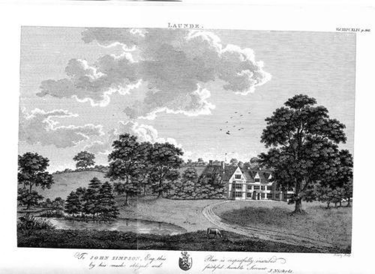
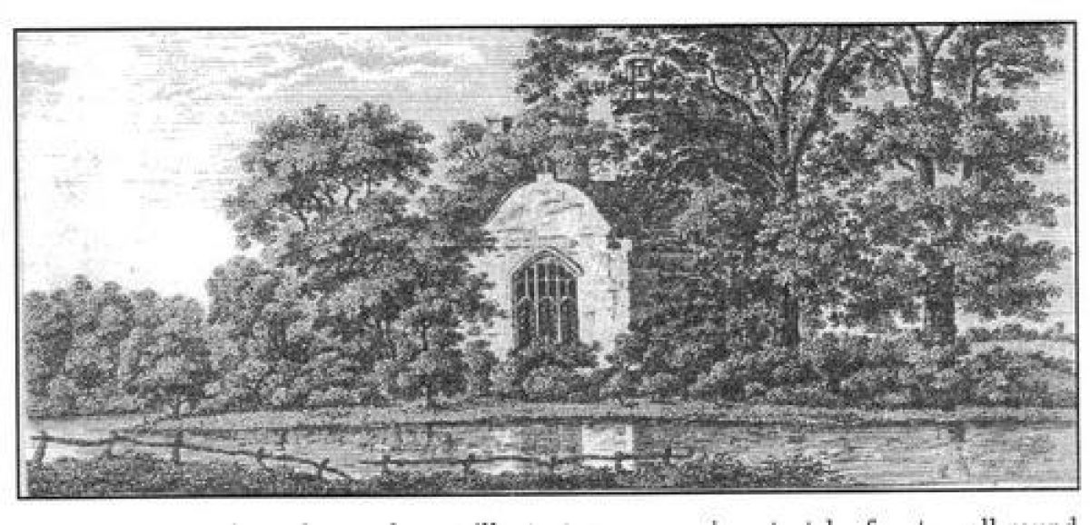
By 1800, the garden was visited by the historian, John Nichols, when no traces of a formal garden remained. Several illustrations show the front façade of the house, pre-dating the construction of the ha-ha. Another engraving shows the chapel with an area of water in the location of the present-day sunken garden.
In the early 19th century, the ha-ha, icehouse, kitchen garden wall and greenhouse were all constructed.
In 1828, Mary Finch Simpson married Edward Dawson (1802-1859) of Long Whatton, bringing the Launde Abbey estate to her husband. In 1829, they engaged Thomas Rickman to add service rooms between the two back wings of the house.
The Dawsons continued to own the estate throughout the 19th century. The garden was in its heyday during this period. Mature trees in the garden, such as wellingtonia, copper beech and cedar of Lebanon appear to date from the second half of the 19th century. There are believed to have been eight gardeners employed.
Edward Dawson was obviously actively involved in the development of the garden and, in 1861, wrote to his brother: 'I am going to begin at once the terrace in front of the house, and I hope by the beginning of May to have it fit to put flowers in. I am also going to move the drying ground next summer, to the place where the present garden is, and make a flower border similar to the south house…. I am busy moving evergreens now'.
In 1865, a visitor, Laura de Lisle, records in her diary that she was playing 'croquet all the afternoon'.
The Ordinance Survey map of 1904 highlights a number of interesting features: there is a fountain in the area which had been a fishpond when John Nichols visited in 1800 (now a sunken garden). In 1904 there were also trees recorded in this area.
There is a substantial network of paths throughout the garden, many no longer existing.
There is a circular structure between the house and the stable block (also shown on the 1884 OS map), possibly the dovecote mentioned in 18th-century documentation. Alternatively, it might be a gas accumulator.
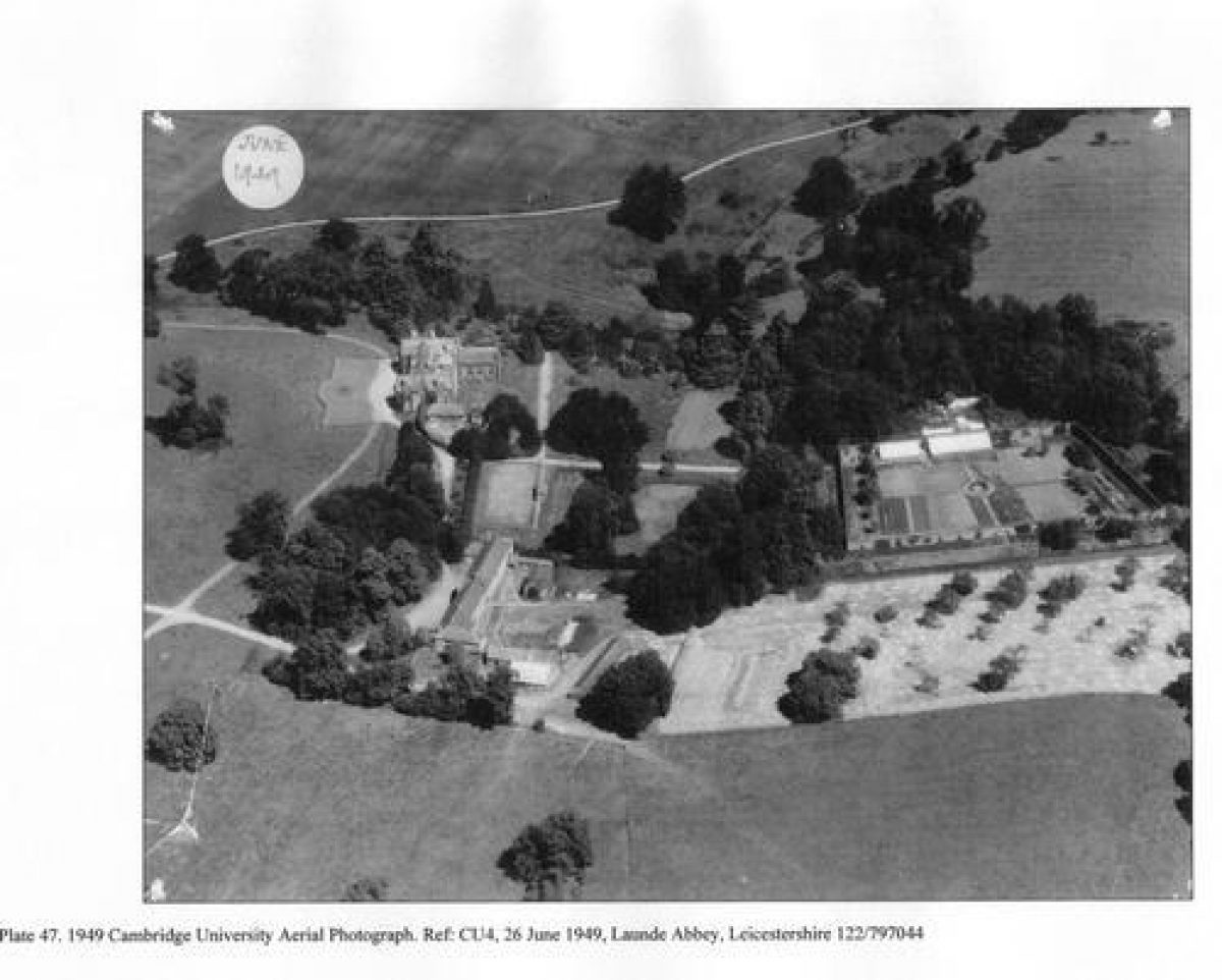
There are a series of buildings to the north of the kitchen garden, occupying the same position at the glasshouses seen in the 1950 aerial photo.
To the south of the walled garden is a substantial orchard area. The aerial photos of the late 1940s show that this had declined considerably.
During this period, John Shillaker was head gardener. His daughter wrote in 1977: 'the gardens were beautiful in those days. Father did a lot of carpet bedding and the greenhouses had peaches, grapes, melons and plants of all kinds'.
In 1886, Edward Finch Dawson (1836-1892) leased out Launde Abbey, furnished. The property continued to be let at various times during the early decades of the 20th century.
In 1932, Lieutenant Colonel Sir Henry Tate left the Army and took Launde Abbey as a hunting and shooting box. He wrote that he had three gardeners, so by this time, the gardens were obviously past their peak. Launde was sub-let during the war years, during which time, paratroopers training for Arnhem also occupied part of the premises.
In 1946, the Dawsons put the house on the market and advertised it in Country Life.
The sale details of 1946 describe 'well-wooded parkland…. Pleasure grounds, hard tennis court. Walled kitchen garden, Orchard, Parkland. About 45 acres'.
In 1954, Launde was on the market again. The sale particulars mention 'lawns, flower and rose beds and walled kitchen garden'.
In 1957 Mr. and Mrs. Cecil Coleman purchased Launde Abbey and presented it to the diocese of Leicester. They paid for the necessary conversion works to make it into the Leicester Diocesan Retreat House and Conference Centre.
In 1986, the stable block was converted for residential use.
- Associated People
- Features & Designations
Designations
Scheduled Ancient Monument
- Reference: SAM ref 137
Style
Informal
Features
- Ha-ha
- Description: Ha-ha and urns: early 19th century. Coursed ironstone rubble with brick coping, forming a curving terrace in front of the house, and capped by a series of ornamental stone urns.The University of Leicester Archaeological Services has carried out (2007) an archaeological evaluation of the ha-ha, to inform restoration plans. This revealed that the western range of the priory lay further to the west than had originally been thought ? approximately on the line of the ha-ha. The ha-ha ditch was found to be relatively shallow and not as silted as had been expected.
- Earliest Date:
- Latest Date:
- Stable Block
- Description: Mid-18th century. Very finely coursed ironstone, almost ashlar work, the hipped roof of Swithland slate to the front slopes, Welsh slate behind. Outer single-storey hipped wings, the main range two storied with central pedimented gable, containing shallow segmental arch with voussoirs and 6-light sash window above. String course emphasises gable which has clock in apex. Four bays to each side, with outer 4-light wood mullioned and transomed windows with single opening lights. Inner doors with overlight. Upper 6-light sash windows. All openings have stone lintels. End bays, behind the low projecting wings, are cottages entered from rear. That to south has a rear wing with two 2-light casement windows to each floor, and inner doorway. Rear windows are largelyconcrete splayed openings with iron glazing bars but to each side of the door is a larger 9-light wood mullioned and transomed window. One upper loading door to each side. In 1986, the stable block was converted for residential use.
- Earliest Date:
- Latest Date:
- Greenhouse
- Description: Late 18th to early 19th century. Brick plinth with stone coping, cast-iron and glass. Long lean-to roof now of plastic corrugated sheeting. At the lowest point at the front there are 20 small sections, each of 10 panes with cast-iron glazing bars. The sides and partition walls have multiple narrow uprights with overlap-ping panes between. Part-glazed doors. Interior: the main struts of the roof frame remain and are supported on very slender cast-iron columns. Brick benches and planters and stone and tile floors. Three niches in the main garden wall which retains its hypocaust heating tunnels at this point.
- Earliest Date:
- Latest Date:
- Icehouse
- Description: Probably early 19th century. Brick. Built into the natural slope above the lake, with now roofless west-facing entrance passage and outer retaining walls. Segmentally arched opening to earth-covered chamber with high threshold now damaged. The domed cavity-walled brick chamber is egg-shaped inside and about 14 foot in diameter.The icehouse is no longer part of the Launde Estate and is on a neighbouring property.
- Earliest Date:
- Latest Date:
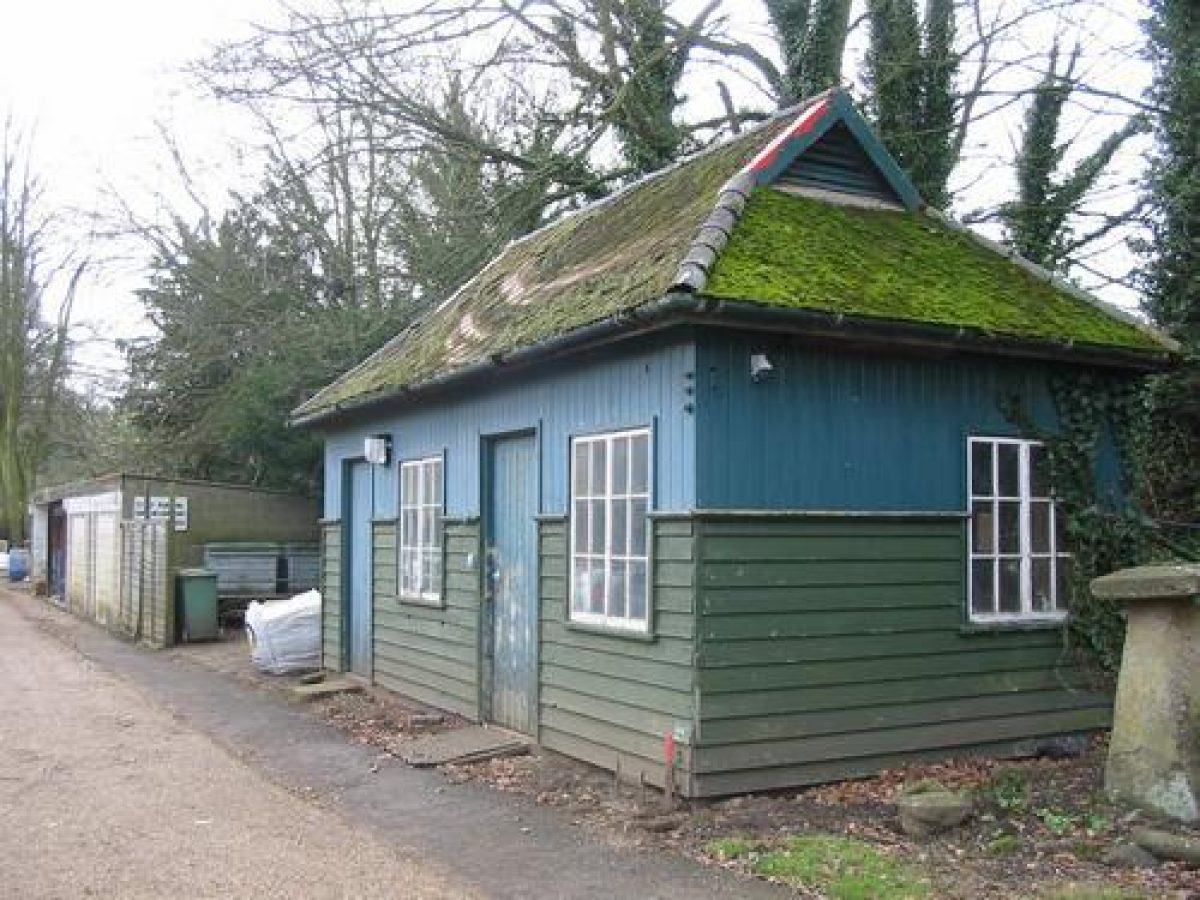
- Bothy
- Description: There are two remaining bothies on the outside north wall of the kitchen garden. They originally extended further along the wall but were demolished in the late 20th century, as there were badger setts beneath them. The listing of the glasshouse inside the kitchen garden states that the bothies are not of special architectural interest.
- Dovecote
- Description: This no longer exists, but is mentioned twice in estate papers, once in 1728 and again in 1765. The 1884 and 1904 Ordinance Survey maps show a circular structure to the south of the service courtyard. In the Historic Building Assessment produced by the University of Leicester Archaeological Services in 2005, it is suggested that this is about the right size to be a gas accumulator, providing lighting for the house, but that a dovecote might be an alternative interpretation of this circular structure. The assessment suggests that a position closer to the stable block would be more usual, and the circular form is a characteristic typical of medieval dovecotes, in which case, earlier documentary references might be expected.
- Pavilion
- Description: The Oxford and Cambridge, a wooden building dating from the 1920s or 1930s, was originally a changing room for the tennis court. During the 1950s it provided accommodation for two ordinands training for the priesthood ? one from Oxford, one from Cambridge. This gave it the name that is used today. It is currently situated near to the south-west corner of the house and is used as a garden store. It is to be moved to a secluded position, near to the Walled Garden, where, with funding from the Heritage Lottery Fund, it will be converted to become a self-contained hermitage for visitors to the Abbey.
- Earliest Date:
- Latest Date:
- Fishpond
- Description: Fishponds are mentioned at various times throughout the history of Launde. In 1728, there were nine 'well-stocked and in good repair'.John Nichols? description of the engravings in his history of 1800 states that ?in both a very fine piece of water is particularly shewn, which has a pleasing effect when approaching this place from Withcote?.Currently, there are a series of ponds to the north-east of the house. Some were previous infilled but `restored? in the late 20th century. There is a pond and well to the west of the stable block, with evidence of other infilled fishponds to the north and west. The sunken garden immediately to the rear of the house occupies the site of yet another infilled pond.
- Tennis Lawn
- Description: This no longer exists but was located between the house and the stables. Aerial photographs show its position and that it still existed in the 1940s. It is not known when it was removed.
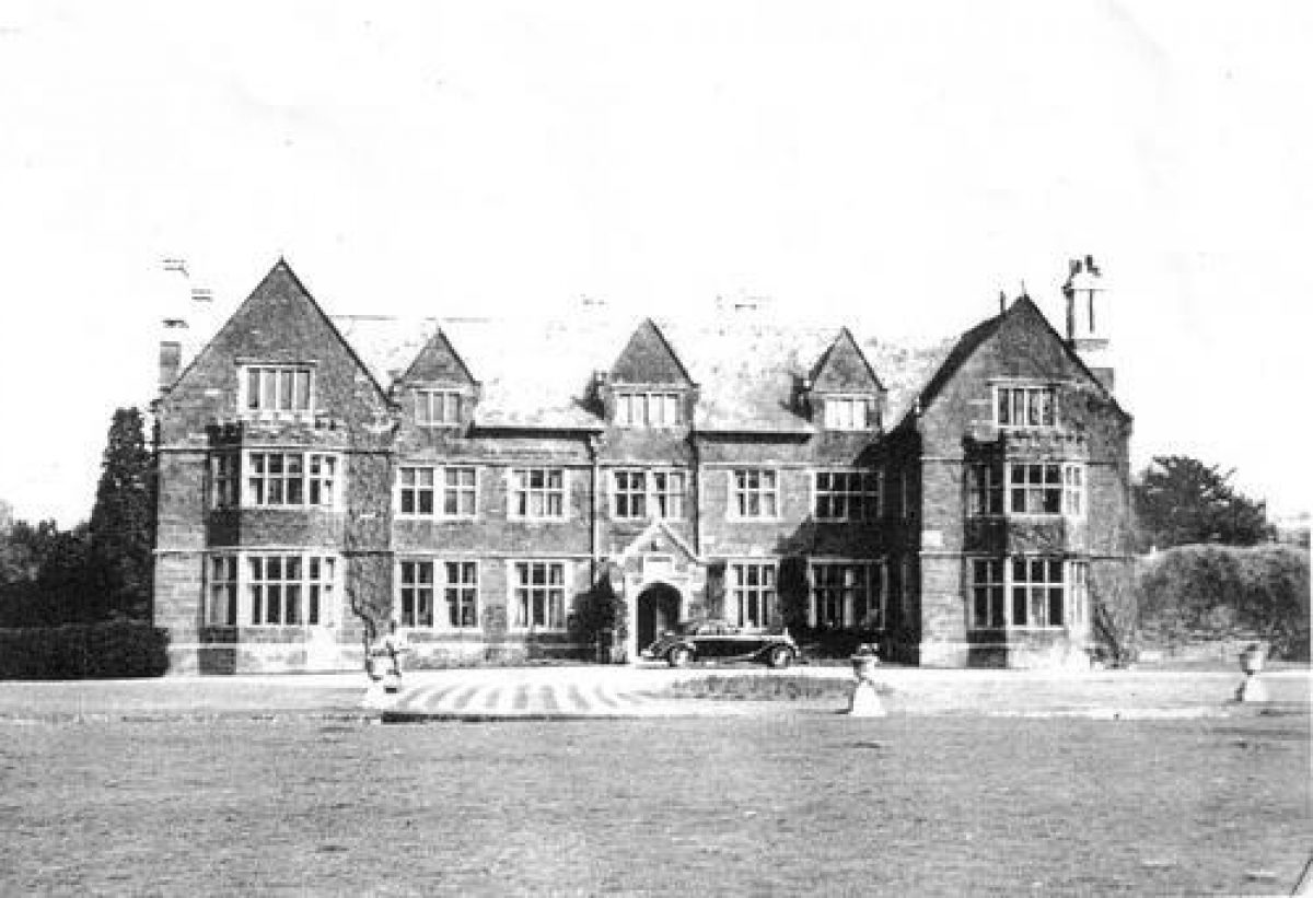
- Country House (featured building)
- Description: A large house dating from the early 17th century, restored and added to in the early 19th century. Finely coursed ironstone rubble with ashlar dressings, and Welsh slate roof. Two-storeyed with attics. Set out on an 'H' plan.
- Earliest Date:
- Latest Date:
- House
- Gardens
- Parkland
- Trees
- Chapel
- Walled Garden
- Glasshouse
- Key Information
Type
Garden
Purpose
Ornamental
Principal Building
Religious Ritual And Funerary
Survival
Part: ground/below ground level remains
Hectares
182
Open to the public
Yes
Civil Parish
Launde
- References
References
- Pevsner, N., {The Buildings of England: Leicestershire and Rutland} (Harmondsworth; Penguin, 1984) The Buildings of England: Leicestershire and Rutland
- Hughes, John C., {Launde Abbey: The Story of the Abbey} (Launde Abbey, 1998) Launde Abbey; The Story of the Abbey
- Finn, Neil, Smith, David, and Hayward, Robert, {Launde Abbey, Launde, Leicestershire. Historic Building Assessment} (University of Leicester Archaeological Services, 2005) Launde Abbey, Launde, Leicestershire. Historic Building Assessment.
- Hyam, Andrew, {An Archaeological Evaluation of the Ha-ha and Stable Block at Launde Abbey, Launde, Leicestershire} (University of Leicester Archaeological Services, ULAS, 2007) An Archaeological Evaluation of the Ha-Ha and Stable Block at Launde Abbey, Launde, Leicestershire
- Beavitt, Paul [Geophysical and Building Survey at Launde Abbey) (Transactions of the Leicestershire Archaeological and Historical Society, 1995) Geophysical and Building Survey at Launde Abbey
- Broughton, H.E. {Family and Estate Records in the Leicestershire Records Office} (Leicestershire Museums Publication, No. 104, Leicestershire Museums, Arts and Records Service) Family and Estate Records in the Leicestershire Records Office
- Blaxland, Sue and Roenisch, Rowan, {Report on the History of the Gardens at Launde Abbey} (2008) Report on the History of the Gardens at Launde Abbey