Introduction
St Michael's Mount has late-19th-century and 20th-century terraced gardens with a marine aspect. The medieval castle has been converted to a mansion house. The grounds, which include sub-tropical hanging gardens, occupy about 9 hectares, of which about 6 hectares are gardens and pleasure grounds.
Terrain
Rocky island.The following is from the Register of Parks and Gardens of Special Historic Interest. For the most up-to-date Register entry, please visit The National Heritage List for England (NHLE):
Mid 18th and 19th century terraced gardens and pleasure grounds around a medieval island fortress which was remodelled in the 18th and 19th century.
Location, Area, Boundaries, Landform and Setting
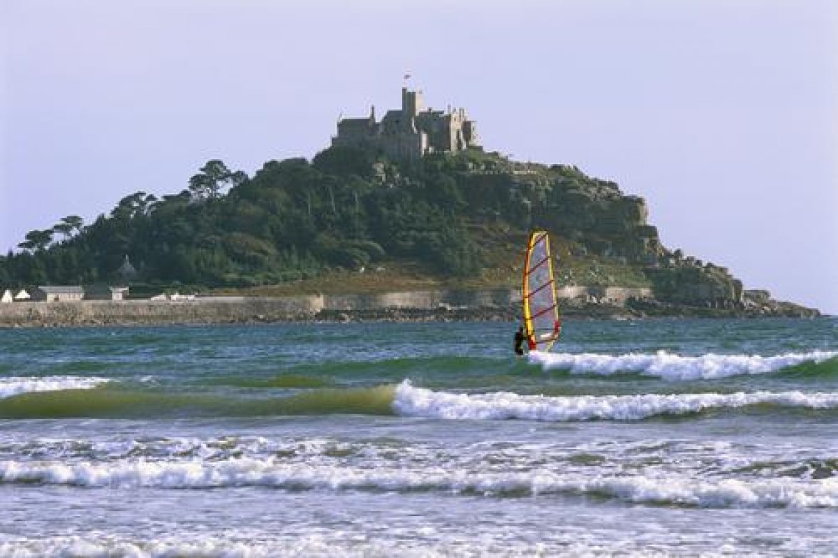
St Michael's Mount is an island linked to the mainland by a tidal causeway, which lies in Mount's Bay some 1km east of Penzance and c 0.25km south of the village of Marazion. The c 9ha site comprises some 6ha of gardens and pleasure grounds, and c 3ha of other land adjacent to the harbour which includes a small cemetery. The Mount rises steeply from rocky coasts to the south, east, and west, with areas of exposed rock below the buildings on the level summit. The slope to the north is less steep and descends to an area of level ground to the north and north-east on which the village and harbour is constructed. The site enjoys extensive marine views to the south-west, south, and south-east, while to the north-east Penzance and Marazion are significant features in an otherwise agricultural landscape. To the east, the west coast of the Lizard peninsular is visible.
Entrances and Approaches
St Michael's Mount is approached from the village of Marazion by boat, or by a stone-cobbled tidal causeway which sweeps south and south-west across the sands to the south of the village. Some 80m south of Marazion the causeway passes to the east of Chapel Rock, site of a chapel built in the early C15. The causeway reaches the Mount adjacent to the eastern pier of the harbour (listed grade II*) where the early C18 Change House (formerly an inn, listed grade II) is today (1999) the Mount office.
The road extends c 90m south, passing to the west of the early C19 Steward's House (listed grade II) and the early C19 Island Shop (listed grade II), today (1999) a visitors' centre and ticket office. A lane leads c 30m east to the late C19 Island Cafe (listed grade II), which was built as the laundry and stands to the north of the Mount cemetery. Three parallel roads to the west of the principal approach lie to the south of the harbour (built C15, rebuilt early C18, early C19, listed grade II*) and are lined with estate buildings, offices, and cottages (all listed grade II), some of which have been converted to late C20 visitors' facilities.
Some 80m west of the Change House a late C19, single-storey, granite-rubble engine house (listed grade II) contains the engine for an underground service railway which ascends a c 150m tunnel to the summit of the Mount; the tunnel was constructed c 1900. The approach is terminated to the north by a granite gateway (listed grade II) built in 1885 which comprises large timber doors set in a Tudor-gothic arch beneath a stepped gable incorporating a carved coat of arms. To the west a lower pedestrian door is set in a similar arch. The gateway adjoins a two-storey, gabled granite lodge (listed grade II) which was constructed to the west in 1885.
Beyond the gateway the drive extends c 80m south before sweeping west and climbing steeply through early C20 rhododendrons and pines. Some 80m north-east of the Castle, the drive passes between two irregularly shaped C17 granite-walled structures which formed the lower gate to the Civil War fortress (Herring 1993). The north-western redoubt, today (1999) known as the Round Garden, is planted with ornamental trees and shrubs, and is shown so-planted in an engraving by Borlase (1754). The south-eastern structure is similarly gardened with walks forming the shape of a Cornish wheel-headed cross. This area was also planted with ornamental subjects in the early and mid C18 (Borlase), and was subsequently used as a pets' cemetery in the late C19 and early C20, from which several memorial stones survive (1999).
Immediately to the west of the south-eastern redoubt the Giant's Well (listed grade II), a medieval or earlier well which until the C19 was the principal source of water on the Mount (Herring 1993), is contained within a granite-walled recess, the floor of which is paved with granite slabs. Adjacent to the Giant's Well a cobbled drive leads south and south-west for c 80m through late C19 and C20 ornamental planting on the rocky east side of the Mount, climbing to reach a small court adjacent to the late C19 domestic wing.
The principal approach continues steeply west-south-west from the C17 redoubts through trees and shrubs planted on the less steep north face of the Mount for c 70m to reach a mid C17 granite gatehouse, wall, and attached guard room and watch tower (all listed grade II*). Beyond the gatehouse the drive turns south and ascends steep rocks to reach a levelled area from which steps ascend to the main entrance set in the west facade of the summit buildings. The area to the west of the buildings is retained by two mid or late C18 gun batteries (both listed grade II*), the larger, to the north-west, supporting a flagpole and eleven cannons within granite embrasures; the smaller, southern battery contains seven cannons. The batteries replaced earlier defences and are likely to have been for ornamental and ceremonial use rather than primarily for defence (ibid).
Principal Building
The buildings on the summit of the Mount comprise church, castle, and C19 mansion. St Michael's Mount (listed grade I) is entered through a gateway set in the west facade. The west range, part of the medieval fortress, comprises two medieval towers flanking a range containing the entrance. The towers were altered in the late C19 by Piers St Aubyn. The entrance leads through the west range to the North Terrace, a large slate-paved rectangular area which is retained by early C19 granite walls and parapets.
There are extensive views north across Marazion and the surrounding country from the terrace. The Terrace extends east round the east end of the Lady Chapel, from the south side of which steps descend to the large South Terrace which occupies the roof of the late C19 domestic wing. There are further extensive views from the South Terrace, including views directly down to the C18 garden terraces. The North Terrace achieved its present form in the early C19, replacing a narrower terrace which was illustrated by Borlase in the mid C18. The site of the North Terrace probably corresponds to that of the medieval priory graveyard (ibid). An irregular projection at the north-west corner of the terrace was added above the late C19 kitchens and is similarly paved and walled.
The C12 church of St Michael (listed grade I) forms the south side of the North Terrace and is approached by a double flight of stone steps ornamented with a C14 lantern cross (scheduled ancient monument). Of simple design, the church comprises a nave, unbuttressed central tower, and choir, while its ornaments are C14 and C15; the church was restored in the C19 and C20. To the north-east of the church the Lady Chapel is today (1999) the Blue Drawing Room: the chapel had fallen into disrepair by the early C18 (Borlase letter, 1731) and was subsequently rebuilt c 1740 as an entrance hall and drawing room. The interior is decorated with gothic plasterwork and the west facade, which was rebuilt with Coade stone ornaments in the early C19, was in the C18 provided with an ogee gable (Borlase, drawing). In the C16 the monastic buildings to the south of the church were converted to domestic use, the refectory becoming the Chevy Chase Room with an elaborate C17 plaster frieze. A late C19 wing containing domestic apartments was added at the south-east corner of the medieval structure to the design of Piers St Aubyn. Comprising three and four storeys with picturesque turrets and oriels, the late C19 range was built against a rock face at a level below the medieval buildings to preserve the characteristic outline of the Mount (Girouard 1979).
Gardens and Pleasure Grounds
The formal terraced gardens lie on the south-eastern slope of the Mount, while informal gardens lie to the south and south-east. There are further areas of informal pleasure ground to the east, north, and west.
The formal gardens immediately below the south-east corner of the Castle comprise a series of three south-facing terraces within a rectangular, stone- and brick-walled enclosure. The upper terrace is approached by late C19 stone steps which descend from the South Terrace to a door set in the east wall of a partly subterranean late C19 shelter which is set in the brick north wall of the terraced gardens. The shelter has a timber-panelled interior with bench seats; open to the south, it is roofed with a single-pitch slate roof. The north-east and north-west corners of the upper terrace are curved and terminate to the south in granite quoins. The upper terrace is planted (1999) with exotic and frost-tender subjects in a central, tile-edged border with further narrow beds below the walls. To the south a low stone parapet retains a bed planted (1999) with low alpines.
Granite steps at the west end of the upper terrace descend to the middle terrace, the widest of the series, which is enclosed to the north by a high brick wall. The east and west walls slope gently to the south, while a timber shelter under a slate roof with a lattice east facade (all rebuilt late C20) stands against the inner face of the west wall, sheltering the foot of the steps descending from the upper terrace and a door leading through the west garden wall. The middle terrace is laid out with perimeter paths and a central rectangular bed planted (1999) with shrubs and tender subjects; there are further narrow beds below the walls which are planted with climbers.
The lowest terrace, some 3m wide, is entered through a door at its south-west corner and is enclosed by granite walls. A central brick path is flanked by tile-edged rectangular borders. The walled gardens were constructed in the mid C18, perhaps replacing the gardens described by Leland in the mid C16 which he noted were on the north-east side of the Mount (Gray 2000); Leland described the south-east slope as being pasture. The walled and terraced gardens were described as 'a hanging garden' by Bishop Pococke in 1750 (Herring 1993) and were noted by William Wynne in 1755 (JRIC 1981). The Rev Swete described a 'neat garden on the south side under [the] steepest part of the rock' (JRIC 1971); these gardens are illustrated in an early C19 view of the Mount (Lysons 1814). To the east of the middle terrace a triangular, low-walled enclosure, today (1999) known as the Tortoise Lawn from the late Lady St Levan's pets which roamed there, is laid to grass. The structure of the Tortoise Lawn existed by 1814 (Lysons), and is probably contemporary with the attached walled gardens (Herring 1993).
To the east of the walled garden the south-east-facing slope below the cobbled drive leading to the late C19 domestic wing of the Castle is laid out in a series of nine informal terraces retained by drystone walls and linked by flights of stone steps. To the north and north-east are exposed, partly planted rock faces, while the terraces are laid out with areas of lawn surrounded by exotic planting. The terraces are enclosed by hedges and late C19 fences to the east, while to the west they adjoin the walled garden. Some 30m south-east of the Castle a reservoir fed by roof water from the Castle is disguised with a low circular wall and late C20 wrought-iron well-head. The eastern terraces were constructed between 1876 and 1908 (OS).
To the west of the walled garden a rectangular, south-facing garden is laid out in a series of terraced beds planted with exotic subjects, linked by grass paths and stone steps. To the west the garden merges with scrub but the remains of a late C19 wire fence supported on cast-iron posts survive (1999). To the south the garden is enclosed by a stone wall surmounted by a clipped hedge. The garden is entered by late C19 wrought-iron gates to the south-east and north-west. A semicircular grassy platform below a rock face to the north of the garden which in the late C19 supported a secluded bower (OS) which predated the construction of the surrounding garden (Herring 1993). The western gardens were constructed between 1876 and 1908 (OS) and have been reclaimed and partly replanted in the late C20 (ibid).
An informal grass walk follows the shore of the Mount. The slope to the north-east below the Castle is planted with pines and ornamental shrubs. Some 30m north-east of the Castle a late medieval lantern cross (scheduled ancient monument, listed grade II) set on an octagonal stone shaft and surmounted by a C19 copper and cement pinnacle is picturesquely placed among pines above a rocky outcrop. The cross was relocated from Sinns Barton, Redruth c 1826 (ibid). To the south, c 30m east of the Castle, Trevean Cross (scheduled ancient monument, listed grade II*), a late medieval wheel-headed cross was relocated from St Erth in 1890 (ibid). Below the rock face to the east of the Castle a wide, gently sloping lawn planted (1999) with groups of herbaceous plants runs down to the rocky shore.
To the north, immediately west of the Mount cemetery and south of the Island Cafe, a rectangular lawn is surrounded on three sides by box-edged flower beds. These are remnants of a larger area of C19 gardens which were removed c 1900 (ibid). Some 190m north-east of the Castle the site of a building emerges from a copse below the rock face. This is believed to have been the site of a banqueting house associated with the priory (Hitchens and Drew 1816); the ruins of this building are shown on an engraving by S and N Buck (1734). The coastal walk follows the south shore of the Mount, passing below the east terraces, walled garden, and west terraces. Some 80m south-east of the Castle a mid C20 pill box stands on the shore on a C17 battery; there are further mid C20 defensive structures to the south-west and west of the Castle, and an C18 battery to the south-south-east. The site of a rabbit warren which existed in 1640 (Herring 1995) lies to the south-east of the walled garden but no trace remains (1999).
The west side of the Mount is partly covered by regenerating elm and naturalised bulbs, while on rocks to the south-west of the Castle the eroded circular concrete bases of two early C20 bathing tents survive (1999). High up among the rocks on the west face of the Mount, and approached from the west side of the Castle by a curved flight of stone steps, a rocky shelter is formed by an overhanging granite rock. Known as St Michael's Cave, this late C19 or early C20 grotto is now (1999) inaccessible. To the north of the Cave C19 brick and slate nest boxes for pigeons survive in clefts in the rocks. The northern slope of the Mount is planted with C20 pines and regenerated elm, with ornamental shrubs on the higher levels adjacent to the cobbled track which ascends to the western entrance to the Castle.
Below the slope, some 100m north-north-east of the Castle, an octagonal stone dairy (listed grade II) with a pitched stone-slated roof surmounted by an octagonal ventilator lantern was built c 1876 to a design by Piers St Aubyn which was based on the Abbot's Kitchen at Glastonbury. To the south a single-storey rectangular range is built into the wooded slope. A herd of six Jersey cows was milked on the Mount until 1909. The dairy replaced a rectangular building, possible associated with a well which survives (1999) immediately west of the dairy. This building is shown on views by Norden (c 1580) and S and N Buck (1734). The pleasure grounds are separated from the village to the north by a stone wall.
Kitchen Garden
Two late C19 rectangular enclosures adjoining the northern boundary wall of the pleasure grounds have been used as kitchen gardens in the C20. To the south, west, and east the gardens are enclosed by hedges, while the two areas are divided by a service drive leading north to the village and harbour. Today (1999) the eastern garden is partly cultivated as allotment gardens and partly laid to grass; the western garden is laid to grass and during the mid and late C20 was used as a tennis court (OS).
The Mount was also supplied from an C18 walled garden to the north of the Manor Office, Marazion (walls listed grade II; outside the area here registered).
Other Land
The Mount cemetery to the east of the lodge (included in the area here registered) achieved its present form c 1877 when the granite walls to the west, north, and east were built, and the gothic lychgate at the north-west corner was constructed (all listed grade II). The cemetery is planted with groups of early C19 ilex oaks (Gardener's Mag 1833) and contains C18, C19, and C20 monuments (some listed grade II). To the south-east the St Aubyn family plot and vault is marked by low granite kerbs.
References
J Norden, Speculi Britannia Pars: Cornwall (2nd edn 1728)
W Borlase, Antiquities Historical and Monumental of the County of Cornwall (1769)
D and S Lysons, Magna Britannia iii, (1814)
F Hitchens and S Drew, The History of Cornwall i, (1816), pp 326
Gardener's Magazine, (1833), p 543
The British Architect, (16 December 1887)
Country Life, 56 (1 November 1924), pp 672-679; (8 November 1924), pp 714-720; no 22 (3 June 1993), pp 84-87
N Pevsner and E Radcliffe, The Buildings of England: Cornwall (2nd edn 1970), pp 193-195
J Roy Instit Cornwall, (1971), p 208; (1981), p 345
St Michael's Mount Illustrated History and Guide, guidebook, (2nd edn 1978)
M Girouard, The Victorian Country House (1979), pp 419, 441
The Garden, (June 1989), pp 271-275
P Herring, An Archaeological Evaluation of St Michael's Mount, (Cornwall Archaeological Unit 1993)
D E Pett, The Parks and Gardens of Cornwall (1998), pp 45-46
T Gray, Travellers' Tales (2000), p 19
Maps
- St Michael's Mount and Mount's Bay, c 1515 (British Library Cotton MS Augustus Ii 34)
- Plan of St Michael's Mount, 1834 (private collection)
- Plan of St Michael's Mount, 1843 (private collection)
- OS 6" to 1 mile: 1st edition published 1876
- 2nd edition published 1909
- OS 25" to 1 mile: 1st edition published 1876
- 2nd edition published 1908
Illustrations
- J Norden, St Michael's Mount from the north, c 1580 (in Norden 1728)
- S and N Buck, The North View of St Michael's Mount, in the County of Cornwall, 1734 (private collection)
- S and N Buck, The East View of St Michael's Mount, in the County of Cornwall, 1734 (private collection)
- W Borlase, St Michael's Mount from the north-east (in Borlase 1769)
- W Borlase, Drawing of the Castle, St Michael's Mount from the north, mid C18 (private collection)
- W Borlase, Drawing of the Castle, St Michael's Mount from the west, mid C18 (private collection)
- J Farington, View of St Michael's Mount from the west, 1813 (Royal Institution of Cornwall)
Archival items
- W Borlase, Draft letter to Dr Oliver, August 1731 (letter book 1,
- Morrab Library, Penzance)
- Collection of 121 C19 and C20 photographs of St Michael's Mount (Royal Institution of Cornwall)
- Richards Collection of photographic plates, including views of buildings and gardens at St Michael's Mount (Morrab Library, Penzance)
Description written: September 1999
Amended: October 2000, March 2001
Edited: October 2001
- Visitor Access, Directions & Contacts
Telephone
44 (0)1736 710265Access contact details
The site is open from 10.30 am between April and November, daily except Saturdays. http://www.nationaltrust.org.uk/place-pages/288/pages/opening-times-calendar
Directions
St Michael's Mount is off the A394 at Marazion over a causeway or by ferry if conditions are suitable. About 3.5 miles east of Penzance.
Owners
The National Trust
Heelis, Kemble Drive, Swindon, SN2 2NA
- History
The following is from the Register of Parks and Gardens of Special Historic Interest. For the most up-to-date Register entry, please visit The National Heritage List for England (NHLE):
HISTORIC DEVELOPMENT
St Michael's Mount has been an important centre from early times. Traces of both Bronze and Iron Age occupation have been found, and the Mount is probably the island of Ictis from which tin was exported to the Mediterranean in the 4th century BC (guidebook). It is likely that secular occupation continued throughout the early medieval period, possibly associated with an early Christian centre (Herring 1993). In the late 11th century the Mount was granted to the monastery of Mont St Michel in Normandy, and a church was built by Abbot Bernard in 1135-1144. The fortification of the Mount followed its seizure by Henry de la Pomeroy in 1193. During the 13th century the island became a centre for pilgrimage. By the early 14th century the harbour had been established, and the Mount was garrisoned during the wars against France. In 1414 Henry V appropriated the Mount as an alien priory, handing it to the Brigettine nuns of Syon; in the late 15th century it was besieged while in the hands of the Earl of Oxford and in 1497 Perkin Warbeck, pretender to the English throne, refortified the Mount. At the Dissolution in 1548 the Mount passed to the Crown, and in 1599 Elizabeth I sold it to Sir Robert Cecil. In the early 17th century the property was let to various tenants before being sold in 1640 to Sir Francis Basset who fortified it for the Crown during the Civil War. The garrison capitulated in 1646 and Captain John St Aubyn was nominated Captain by Parliament; he purchased the Mount from Sir Francis Basset's son in 1659. Colonel St Aubyn died in 1684 and was succeeded by his son, John (d 1699), who was created a baronet. The third Baronet, also Sir John, succeeded in 1722. A politician and opponent to Sir Robert Walpole, Sir John commissioned repairs to the buildings on the summit of the Mount before his death in 1744. This work continued under his son, Sir John, fourth Baronet, who died in 1772. The fifth Baronet, also Sir John, spent lavishly and married his second mistress in 1822. On his death in 1839 the Mount passed to his eldest illegitimate son, James, who in turn was succeeded in 1862 by his younger brother Edward, who was created a baronet in 1866. Sir Edward's son, Sir John, inherited in 1872 and was created Lord St Levan in 1887. The house was extended by Piers St Aubyn for Sir John in 1873-1878, while the gardens were extended by the second Lord St Levan who succeeded his father in 1908. Under the third Lord St Levan, who inherited in 1940, the Mount was fortified against possible German invasion, von Ribbentrop, the Nazi Foreign Minister having chosen the Mount as his place of residence in the event of German victory (guidebook). In 1954 Lord St Levan gave St Michael's Mount together with a substantial endowment to the National Trust. Part of the gardens was reserved from this gift, and a lease of part of the Castle was granted to the family. Today (1999) St Michael's Mount remains in divided ownership.
- Features & Designations
Designations
The National Heritage List for England: Register of Parks and Gardens
- Reference: GD1645
- Grade: II
Plant Environment
- Plant Type
- Exotic Garden
Features
- Mansion House
- Castle
- Pleasure Garden
- House
- Key Information
Type
Garden
Purpose
Ornamental
Plant Environment
Plant Type
Principal Building
Domestic / Residential
Survival
Extant
Hectares
9
Open to the public
Yes
Civil Parish
St. Michael's
- References
References
- {English Heritage Register of Parks and Gardens of Special Historic Interest} (Swindon: English Heritage 2008) [on CD-ROM] Historic England Register of Parks and Gardens of Special Historic Interest
- Girouard, M {The Victorian Country House} (London: Yale University Press, 1979) 419, 441 The Victorian Country House
- Pevsner, N and Radcliffe, E {The Buildings of England: Cornwall} (Harmondsworth: Penguin, 1970) pp 193-195 The Buildings of England: Cornwall
- Pett, D E {The Parks and Gardens of Cornwall} (1998) pp 45-46 The Parks and Gardens of Cornwall