Introduction
Trengwainton is a 20th-century woodland garden. There are some 30 hectares of pleasure grounds around the house and in a valley to the west, and about 17 hectares of parkland.
Terrain
The site rises from the south and south-east towards the house and parkland to the north, while about 400 metres west of the house a steep-sided valley and stream run from north-west to south-east.There is an extensive collection of woody plants, many of which are tender thanks to the sheltered position of the site and the Gulf stream.
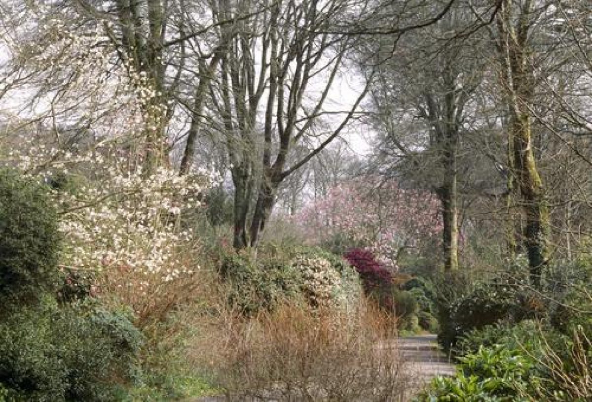
The garden is long and thin, flanking a drive that winds uphill adjacent to a stream. Planting includes primulas, lilies and astilbes. There are rhododendrons and azaleas near to the top of the garden, before the path opens onto a terrace with views over Mounts Bay and the Lizard Peninsula.
Close to the entrance is a series of walled gardens containing several rare species from four continents, including camellias, fuschias and an 80 year old magnolia. The walled kitchen gardens have sloping beds which are considered unique. A variety of garden crops is gradually being re-introduced. There is a viewing platform to enable the better appreciation of the grand scale of these structures, which were built to the dimensions of Noah's Ark.
The following is from the Register of Parks and Gardens of Special Historic Interest. For the most up-to-date Register entry, please visit the The National Heritage List for England (NHLE):
www.historicengland.org.uk/listing/the-list
Early 19th century pleasure grounds, parkland, and walled garden, with a woodland garden planted with rhododendrons, magnolias, and half-hardy trees and shrubs in the early and mid 20th century.
DESCRIPTION
Location, Area, Boundaries, Landform and Setting
Trengwainton is situated c 0.5km south-west of the village of Madron, some 2km north-west of Penzance and the coast. The c 47ha site comprises some 30ha of pleasure grounds around the house and in a valley to the west, and c 17ha of parkland. The site is bounded to the east by a minor road leading north from Tremethick Cross to Madron, and to the north-east and north by a minor road leading to Boswarthan Lodge. To the north-west the site adjoins rough grazing and moorland, while to the west, south-west, and south it adjoins agricultural land. The site rises from the south and south-east towards the house and parkland to the north, while c 400m west of the house a steep-sided valley and stream run from north-west to south-east. There are significant views south-east from the terrace south of the house, across the park and adjacent agricultural land towards Mount's Bay and St Michael's Mount (qv). There are further views from the early C19 south drive south and south-east towards the sea and Newlyn.
Entrances and Approaches
Trengwainton is approached from the minor road to the east c 0.5km south of Madron, at its junction with Boscathnoe Lane. An early C19 single-storey stuccoed lodge with a Doric porch on the east facade (listed grade II) stands immediately within the site to the north of the drive. To the south of the drive, an identical lodge was constructed in 1994 and now (1999) serves as the visitors' reception and shop. White-painted cast-iron railings with spear finials are supported on a low stone plinth and stone piers to north and south. Open-lattice cast-iron piers surmounted by ball finials stand c 5m to the north and south of the entrance, which is flanked by further piers supporting cast-iron gates. The early C19 railings, piers, and gates were removed for the war effort in 1943, and the present railings, following the original pattern, were erected in 1989 (guidebook).
The tarmac drive climbs gradually towards the house c 720m north-west of the entrance. Entering the site, the drive runs c 190m west, to the south of the early C19 walled gardens. It then turns north-west, and continues for c 450m through an area of pleasure grounds developed with specimen trees and shrubs from 1925. To the north there are views through metal estate fencing to the park, while to the south the drive is separated from a stream by a wide grass verge planted with spring bulbs. This stream was opened from a culvert in the 1920s under the supervision of the head gardener, Mr Creek.
Sweeping west and south for c 130m, the drive enters the gravelled carriage court to the north of the house which is enclosed by mature trees and ornamental shrubs. To the north of the carriage court, and concealed by shrubbery, lie the stables and coach house (listed grade II), which were constructed in the late C18 and extended in the late C19. A service drive leads c 210m north-north-east and north to reach the minor road to the north of the site. The present principal drive was constructed by Thomas Robins Bolitho in 1897, to replace a narrower and more winding early C19 drive to the south-west which had been constructed by Sir Rose Price. Price's drive was flanked by extensive plantings of beech, ash, and sycamore, and was retained by T R Bolitho as the Long Walk, now (1999) a gravel walk leading south-east from the house through the C20 pleasure grounds to join the principal drive at a point c 100m west of the walled gardens.
A further early C19 drive approaches the house from the south, leaving the minor road at a point c 80m west of Chynoweth. A mid or late C19 two-storey stone lodge stands in simple, late C20 gardens to the south-west of the entrance, which is flanked by simple stone piers. The drive runs west-north-west through a narrow belt of trees for c 160m, passing a drive to Hendra, a former farm, to the north. Continuing for c 300m, the drive passes through light woodland, with a stream to the north separating it from a paddock or park enclosure on a south-facing slope below the pleasure grounds.
Turning sharply north and passing through a simple timber gate supported on stone piers, the drive leads through a plantation and ascends the south-facing hillside in three zig-zag sweeps. The south-east-facing corners reveal views south and south-east across the park and agricultural land towards the sea and Newlyn, while the north-east-facing corners allow views across meadows to moorland to the north. Crossing a farm track c 190m south-west of the house and passing through a gateway set in the stone wall separating the pleasure grounds from the park, the drive runs north c 250m to reach the rear of the stables; its original course north-east to the former entrance on the south-east facade of the house was replaced in the late C19 by a series of pleasure-ground walks. The south drive is today (1999) disused and partly overgrown.
Principal Building
Trengwainton House (listed grade II) is built on a level terrace from which the land falls to the east and south-east, and rises to the north and north-east. The present house comprises an C18 structure remodelled c 1810 by Sir Rose Price, which was extended and further remodelled in 1882 for T S Bolitho, and again in 1897 by J P St Aubyn for T R Bolitho. During this late C19 remodelling, much of the Tudor house, together with the C18 and early C19 house, was demolished. Trengwainton House is mainly of two storeys with an attic, and is constructed in granite ashlar and stuccoed rubblestone. The late C19 two-storey north or entrance facade has a two-storey canted bay to the west, with a large Tuscan porch and a roof balustrade. The east facade, the entrance facade of the early C19 house but the garden facade since the late C19, is symmetrical, with a pair of pediments linked by a roof balustrade above round-headed windows on the first floor which surmount large, square-plan projecting ground-floor bays. The bays flank a central porch with Tuscan columns. The south or garden facade reflects the evolution of the house, with work from the C18, early C19, and late C19 being visible. The early C19 service quarters lie to the west of the principal range.
Gardens and Pleasure Grounds
The informal gardens and pleasure grounds lie principally to the south-east, east, and south of Trengwainton House, with a further area of pleasure grounds being situated in the valley to the west of the house.
To the east of the house informal lawns fall gently to the east and south-east from a gravelled terrace on which stands a stone baluster sundial dated 1909. Large groups of rhododendrons frame long vistas east to St Michael's Mount, and south-east to Mount's Bay near Newlyn, while the lower lawn is flanked by mid C20 summer borders designed by Graham Stuart Thomas. To the south of the house a level lawn terraced into an east-facing slope was used as a tennis lawn in the late C19, while the slope to the west was planted with ornamental shrubs including magnolias, beyond which a belt of mature trees serves as a shelter belt. Some 130m south of the house a broad gravelled terrace runs c 130m south-west from the southern corner of the east lawn. Retained on its south-east side by a granite ashlar wall c 1m high, the remains of the C19 ha-ha, and sheltered to the north-west by trees and shrubs, the terrace is terminated at each end by late C20 white-painted trellis summerhouses of timber construction designed by Paul Edwards.
To the south-east of the terrace, and parallel with it, a level lawn is separated from parkland by a late C19 ha-ha constructed from granite blocks. The south-west end of the ha-ha was realigned in the 1920s to allow the construction of two grass tennis courts. Following the removal of the remaining hard tennis court, the ha-ha was straightened to its original line in 1997-8. From the terrace, summerhouses, and adjacent lawn there are fine views south-east across the park towards Mount's Bay, St Michael's Mount, and Newlyn, views framed by belts of trees to the south of the entrance drive and to the south of the terrace. The terrace and the construction of the south-east vista formed part of Sir Rose Price's embellishments of the grounds at Trengwainton, undertaken with the advice of George Brown c 1813-17 (Pett 1998).
Stone steps at the north-east end of the terrace descend to a late C20 gravel path which leads east across the south corner of the east lawn to join a network of walks to the south of the principal drive. Here, under mature trees planted by Sir Rose Price in the early C19, Col Sir Edward Bolitho developed a woodland garden from 1925. The early C19 drive, known since the late C19 as the Long Walk, and the stream which was released from a culvert in the 1920s, run parallel to the principal drive and form the principal features of this area, between which distinct garden areas or glades are created. Some 130m south-east of the house a stone-edged, irregular-shaped pond surrounded by mature tree ferns was constructed at the head of the stream in 1997, with a timber bridge (1998-9) crossing the outflow. To the north is a further grove of tree ferns adjacent to the Azalea Garden, planted in 1931 (guidebook).
Other areas adjacent to the drive include the Stream Garden with moisture-loving plants and rare rhododendrons, and the Jubilee Garden c 650m south-east of the house, which was planted in 1977 in an area known in the C19 as the Vineyard. To the north of the drive, c 480m south-east of the house, The Meadow is a small arboretum which contains, among other trees and shrubs, specimens associated with or planted by members of the Royal family. Immediately to the west of the walled gardens, the Camellia Walk was planted by Lt Col E H W Bolitho in 1939, while to the east of the walled gardens a late C20 path leads north to the visitors' car park in a belt of mature trees.
The pleasure grounds in the valley c 400m west of the house are reached by the early C19 south drive, from which a carriage drive leads north-west into the valley. Created in the early C19 as part of Sir Rose Price's improvements, this is today (1999) an area of light woodland with several mature beech trees surviving from Price's planting. A stream running south-east through the valley is dammed to form a widely spaced chain of three ponds. Some 800m west-north-west of the house a large rectangular pond is retained by a substantial earth dam to the south; a boathouse on the east bank marked on the late C19 OS map does not survive. Some 80m below the rectangular pond there is a further square pond, while c 530m south-east of these two ponds and c 500m south-west of the house is a narrow, wedge-shaped pond. To the west of this pond an early C19 brick icehouse is built into the steep, east-facing slope under mature trees and evergreen shrubs.
Park
The parkland at Trengwainton falls into three distinct areas: to the north and east of the house, to the south-east, and to the south. Today (1999) these parkland enclosures remain pasture. The park to the north and east of the house lies on rising ground above the house, drive, and pleasure grounds, and is visible from the drive. Ornamental tree planting includes a clump of trees c 250m east of the house, and a scattered group of mature pines c 450m south-east of the house. The south-east park comprises a single enclosure on the south-east-facing slope below the terrace. This area of parkland is enclosed to the north and south-west by blocks of mature trees which originate from Sir Rose Price's early C19 planting. The south-east park serves as the foreground to the significant vistas from the terrace and east lawn. The south park is similarly a single enclosure which lies on the south-facing slope below the pleasure grounds c 100m south of the house. It is bounded to the south and west by light woodland through which runs the early C19 drive, and to the east by Hendra farm, while to the north it is separated from the pleasure grounds by a C19 stone wall.
Kitchen Garden
The kitchen garden lies on a south-facing slope c 530m east-south-east of the house and to the west of the principal entrance. Enclosed by red-brick walls c 3m high (listed grade II), the kitchen garden is approximately square on plan, with an irregular southern boundary closed by a Cornish hedge rather than a wall. It is divided into two approximately equal sections by an east/west wall, with a large single enclosure to the north, and a series of ten small, walled enclosures to the south arranged in two east/west rows of five. The southern enclosures are of varying area but are generally laid out with a series of ramped beds retained by brick walls; the beds face west and were designed for the cultivation of early and tender vegetables. These beds are particularly evident in the five northern enclosures, which remain (1999) a kitchen garden and nursery. The five southern enclosures were developed from c 1925 as ornamental gardens, with many rare and tender trees and shrubs being planted within the walls by Col Sir Edward Bolitho.
A gothic-arched doorway in the centre of the north wall leads from the southern, ornamental enclosures to the five kitchen garden enclosures, the centre one of which retains a central circular dipping pool surrounded by rustic rockwork and ferns. The three terraced early C19 gardeners' cottages (now one cottage; listed grade II) are built into the north wall of the central enclosure, which is today (1999) laid out with a variety of exotics which use the early C19 vegetable beds. A further gothic-arched door to the west of the gardeners' cottages leads to the large northern walled enclosure, which is planted as an orchard with standard apples and pears, some being rare Cornish varieties. Beyond the orchard lies the service, frame, and glasshouse yard. An early C19 bothy (listed grade II) survives c 25m north-west of the walled garden and comprises a two-storey stone cottage with two lower rooms, one with a fireplace and timber panelling ornamented with C20 horticultural prize certificates; to the west of the bothy is an early C20 single-storey brick potting shed (listed grade II).
Some 25m to the north-east stands a late C19 or early C20 range of timber glasshouses and frames, with stone-built sheds to the north. Some 25m to the east of the bothy is a C19 single-storey apiary of stone and timber construction under a pitched slate roof. The apiary comprises a shed with a timber facade to the south in which are cut small entrances for bees; inside timber shelves formerly supported bee hives. Adjacent to the north-east corner of the walled garden is a modern single-storey restaurant which stands above south-facing sloping lawns. To the east of the walled garden a segmental-shaped walled yard is laid to gravel with C20 ornamental planting adjacent to the walls; this early C19 yard was formerly used for storing manure for use in the adjacent garden (J Pearson pers comm, 1999).
Service drives lead east and north-north-west from the frame yard to join the minor road which runs to Boswarthan Lodge (outside the site here registered). An area of woodland beyond the road is included in the registered site.
The walled gardens were constructed for Sir Rose Price c 1814-20, from bricks made on the site from clay imported by sea from Somerset (guidebook). The gardens are said to be built to the dimensions of Noah's Ark, 300 cubits long by 50 cubits wide (ibid), and the ramped vegetable beds are considered to be unique, although similar examples survive at Cotehele, Cornwall (qv).
References
J A Paris, A Guide to the Mount's Bay and the Land's End ... by a Physician (1824), p 119
E Twycross, The Mansions of England ... Cornwall (1846), p 76
Lake's Parochial History of Cornwall iii, (1870), pp 219-220
Gardeners' Chronicle, ii (1894), p 732
Gardening World, (1904), p 477
E Thurston, British and Foreign Trees and Shrubs in Cornwall (1930), p 65
Gardening Illustrated (1938), p 89
P M Synge, Gardens of Britain I, (1977), pp 123-124
G S Thomas, Gardens of the National Trust (1979), pp 229-231
G M Trinick, The National Trust's Cornish Gardens (1981)
The Garden 116, pt ii (November 1991), pp 595-599
S Pring, Glorious Gardens of Cornwall (1996), p 113
Country Life, no 13 (26 March 1998), pp 64-69
D E Pett, The Parks and Gardens of Cornwall (1998), pp 48-49
Trengwainton Garden, guidebook, (National Trust 1999)
Maps
J Norden, Speculi Britanniae, surveyed c 1597, published 1728
Tithe map for Madron parish, c 1840 (Cornwall Record Office)
Archival items
Sale particulars for Trengwainton, 1866 (Cornwall Record Office)
Description written: October 1999
Amended: October 2000, July 2001
Edited: October 2001
- Visitor Access, Directions & Contacts
Telephone
0844 800 1895Website
http://www.nationaltrust.org.ukAccess contact details
The site is open between February and November, 10.30am to 5pm. It is closed on Fridays and Saturdays. https://www.nationaltrust.org.uk/place-pages/337/pages/opening-times-calendar
Directions
The gardens are 2 miles north-west of Penzance off the B3312.
Owners
The National Trust
Heelis, Kemble Drive, Swindon, SN2 2NA
- History
The site has been inhabited since the 16th century. In 1814 it was bought by Rose Price, who made considerable improvements to the house and garden.
The following is from the Register of Parks and Gardens of Special Historic Interest. For the most up-to-date Register entry, please visit the The National Heritage List for England (NHLE):www.historicengland.org.uk/listing/the-list
HISTORIC DEVELOPMENT
The property of the Cowling family in the late medieval period, Trengwainton was sold to Francis Arundell of Menadarva in 1668 (Lake 1870). The Arundells rebuilt the house in 1692, but subsequently sold the estate to the Praeds of Treventhoe, who let it as a farm. Trengwainton continued as a farm until the early 19th century, when, in 1813, it was purchased by Sir Rose Price, a wealthy Jamaican plantation owner who had originated from Penzance. Price lived at Kenegie, Gulval from 1813 to 1817 while rebuilding the house, and forming extensive pleasure grounds at Trengwainton under the direction of 'Mr George Brown' (Pett 1998). The Abolition of Slavery in 1833 depleted Price's fortune, and following his death in 1834, Trengwainton was sold to the mortgagees, who in turn sold it on to Henry Lewis Stephens in 1835.
The house was reduced in size and used for a time as a farm, until it was acquired in 1867 by Thomas Simon Bolitho, who, like Sir Rose Price, was living at Kenegie. Thomas Bolitho's son, Thomas Robins Bolitho, an agricultural reformer, extended the house and made alterations to the grounds. Dying without issue in 1925, T R Bolitho left Trengwainton to his nephew, Lieutenant-Colonel E H W Bolitho (later Sir Edward) of York House, Penzance. With the advice and encouragement of his cousins, J C Williams of Caerhays Castle and P D Williams of Lanarth, and of Canon Boscawen of Ludgvan, Colonel Bolitho began to develop the gardens with choice trees and shrubs. George Johnstone of Trewithen and Lawrence Johnston of Hidcote Manor, Gloucestershire offered Colonel Bolitho a share in F Kingdon Ward's expedition to Burma and Assam in 1927-1928, which resulted in plants being raised from seed by the head gardener, A Creek, which formed the basis of the collection of species rhododendrons at Trengwainton (Thomas 1979). Colonel Bolitho and Creek also raised hybrid rhododendrons at Trengwainton, this work continuing after Creek's retirement in 1934 with the assistance of G W Thomas.
In 1961 Colonel Sir Edward Bolitho gave Trengwainton House and gardens to the National Trust, with provision for the family to remain in residence. The estate passed to his son, Major Simon Bolitho, and today (1999) the site remains in divided ownership.
- Associated People
- Features & Designations
Designations
The National Heritage List for England: Register of Parks and Gardens
- Reference: GD1648
- Grade: II*
Plant Environment
- Plant Type
- Exotic Garden
Features
- River
- Terrace
- Summerhouse
- Structure
- Description: Walled gardens
- Kitchen Garden
- Description: The walled kitchen garden have sloping beds which are considered unique.
- House (featured building)
- Description: The house was rebuilt from 1813 and extended after 1867.
- Earliest Date:
- Latest Date:
- Parkland
- Pleasure Garden
- Woodland garden
- Key Information
Type
Garden
Purpose
Ornamental
Plant Environment
Plant Type
Principal Building
Domestic / Residential
Survival
Extant
Hectares
47
Open to the public
Yes
Civil Parish
Madron
- References
References
- {English Heritage Register of Parks and Gardens of Special Historic Interest} (Swindon: English Heritage 2008) [on CD-ROM] Historic England Register of Parks and Gardens of Special Historic Interest
- Pett, D E {The Parks and Gardens of Cornwall} (1998) pp 48-49 The Parks and Gardens of Cornwall
Contributors
Ian Wright