Introduction
The gardens at Godolphin occupy about 3.5 hectares within an estate of 210 hectares. The garden was first laid out in the 14th century with adaptations in the 16th century. Since then it has been little altered, and is considered to be one of the most important historic gardens in Europe.
Terrain
. The site rises south from the River Hayle to Godolphin Hill c 1km south-west of the house, with mixed woodland concentrated in the river valley and around the house, and with heathland on the slopes of the former deer park on Godolphin Hill.The following is from the Register of Parks and Gardens of Special Historic Interest. For the most up-to-date Register entry, please visit the The National Heritage List for England (NHLE):
www.historicengland.org.uk/listing/the-list
Formal gardens and ornamental orchards dating from the 15th century with earlier elements, together with a late medieval deer park and a 16th century deer course surrounding a late 15th century mansion.
DESCRIPTION
Location, Area, Boundaries, Landform and Setting
Godolphin lies c 0.5km north-west of the hamlet of Godolphin Cross, south of a minor road which runs north-west from Godolphin Cross to the hamlet of Townshend some 1.25km north-west on the B3280. The 210ha site comprises c 3.5ha of gardens and orchards, and some 206ha of former deer park, woodland, and landscaped tin workings and agricultural land which formerly lay within the deer park.
The site is bounded to the south-west, south, and south-east by a park pale adjacent to Rocky Lane, Great Work mine, and properties in Godolphin Cross. To the east, stone walls and a short stretch of deer fence on the road leading from Godolphin Cross to Townshend form the boundary, while to the north and north-east the River Hayle, traditional hedge banks, and a minor track north of the ornamented mine spoil form the boundary. To the north-west and west the site is enclosed by a minor road leading south from Godolphin Bridge to Trescowe Common, and by a series of late C18 and early C19 enclosures.
The late medieval park extended beyond the present site boundary as far as the River Hayle c 500m to the north-west. The site rises south from the River Hayle to Godolphin Hill c 1km south-west of the house, with mixed woodland concentrated in the river valley and around the house, and with heathland on the slopes of the former deer park on Godolphin Hill. From the hill there are wide views across the site and beyond in all directions.
Entrances and Approaches
The site is approached from the minor road leading from Godolphin Cross to Townshend at a point to the north of the house c 1.1km north-west of Godolphin Cross. Serpentine stone wing walls with relocated C17 coping and stone pyramid-capped piers flank similar gate piers which support a single C19 timber gate (all listed grade II). These lead to the gravelled drive running c 180m south-south-west and south through mixed deciduous planting which preserves elements of a C17 or C18 formal scheme (Schofield 1999).
The change in direction c 160m north of the house adjacent to the north-west corner of the Orchard was marked by a gateway (Tithe map, 1839) which was the northern limit of the early C17 pleasure grounds. The gateway was removed before 1876 when it was replaced to the north by the present entrance. Some 50m north of the house the Iron Gate, a late C19 gateway with relocated granite piers surmounted by C17 stepped pyramidal caps and C19 wrought-iron gates (listed grade II) leads through C19 shrubbery and specimen trees to the mid C17 forecourt north of the house (walls listed grade I).
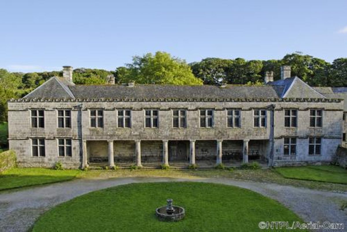
The Forecourt assumed its present form in the early C19 when its early C17 north wall and a pair of earlier square, pyramid-roofed corner lodges (shown in a mid C18 drawing by W Borlase) were removed, and a new rubble-stone wall was built c 35m further north adjacent to the new Iron Gate. Early C17 granite-rubble coped walls survive to east and west with distinctive Cornish stiles with granite 'cattle-grid' bases and high-backed granite benches to each side leading to the orchard and the stable yard (listed grade I). The gravelled Forecourt has a central circular lawn ornamented with a C15 octagonal piscina or fountain column (listed grade II), having been adapted in the C18 as a sundial and placed on a cider-press base c 1960. The central lawn was established by 1786 (estate plan), but traces of early C17 cobbled paths connecting the mansion to the north gate, stiles, and the lodges survive from an earlier cobbled and gravelled surface.
The north approach replaced the early C14 west approach (which survives as Vane's Lane west of the farm and stableyard) as the principal access to the house in the early C16 when the road from Breage to Trescowe was diverted from below the north facade to its present course c 300m north. A secondary drive leads south-west from the Iron Gate to the late C16 stables (listed grade I) and the C18 and C19 farm buildings (all listed grade II) which stand at the east end of Vane's Lane, to the west of the house and Forecourt.
Principal Building
Godolphin House (listed grade I) is a mansion of late C15 origin standing immediately north of the site of an early C14 defended house which occupied the central compartment of a walled and moated precinct. The late C15 house was superimposed on this medieval precinct, and its principal axes clash with those of the enclosure and gardens. By the 1530s the house comprised two courtyards separated by a hall range, with a symmetrical north front flanked by towers to east and west.
In the late C16 and early C17 Sir Francis I (d 1608) made significant changes including the construction of ranges around the southern courtyard (largely demolished c 1800), and the stables west of the house. Under Sir William III (d 1613) the west range was provided with its present Green Court facade. Sir Francis III implemented a bold reconstruction of the north range after succeeding in 1627. This flat-roofed wing has distinctive loggias with ground-floor Tuscan colonnades on both the entrance and Green Court facades which support a first-floor link between the east and west wings, and was completed by 1634 as the first part of a projected rebuilding frustrated by the Civil War. Sir Francis' connection with Lord Pembroke of Wilton, Wiltshire (qv) and Roger Townshend of Raynham, Norfolk (qv) are significant, and Godolphin as remodelled by Sir Francis III was a visible statement of the family's leading position in Cornwall.
Few changes were made to Sir Francis' house until c 1800 when the fifth Duke of Leeds demolished the Great Hall and structures to the south, leaving the present reduced north facade of the Hall and a partly rebuilt porch facing the Green Court as a picturesque feature. Today (1999) the house comprises the east and west wings, together with the early C17 north wing.
Gardens and Pleasure Grounds
The gardens and pleasure grounds lie to the north-east, east, and west of the house and include the Green Court, Side Garden, Orchard, King's Garden, Mowhay, and Water Garden. The Green Court or central courtyard of the present house is overlooked by the colonnaded walk on the ground floor of the north range, and comprises stone-flagged perimeter walks and two panels of lawn with an off-centre stone-flagged path leading from the north door to the porch of the Great Hall on the south side of the Court. The north wall of the Hall was reduced c 1800 and its castellated parapet lowered. The interior of the site of the Hall was paved with granite flags in the mid C20, while to the south a terraced lawn was created at the same period. This garden is enclosed to the south by a stone wall which separates it from the Cow Yard beyond.
The late C15 Side Garden east-south-east of the house comprises nine roughly square compartments separated by cross-walks and arranged in a three by three pattern c 130m by 100m, rising to the south-east and bounded by rubble-faced raised walks to the north, east, and south. The three western compartments which remain gardened today (1999) appear from archaeological evidence to survive from the layout of the early C14 precinct. The six eastern compartments are now divided from the present garden by a mid C19 rubble-stone wall c 50m east of the house, and the late C15 and C16 layout survives as banks and archaeological features in the Garden Paddock.
The surviving gardens retain elements of the late C15 and C16 layout including perimeter walks around the north-west compartment (effectively a sunken garden), stone steps at its north-east corner, and a box hedge running north/south c 30m east of the house which dates from at least the C18 (estate plan, 1786). The 1786 estate plan shows garden compartments with simple rectilinear subdivisions which may have replaced an earlier, more complex scheme of geometric beds, while a small garden building in the north-east compartment shown in 1786 and 1876 (OS) has not survived (P Herring pers comm, 1999).
The south-west compartment c 70m south of the house is partly raised behind a rubble-stone retaining wall and contains a rectangular pond or tank (dry, 1999) surrounded by a grass walk. This pool was later truncated by the construction of a further rectangular pond (dry, 1999) on a north/south axis c 10m east, probably in the late C17 or early C18 (Schofield 1999). The terrace overlooks a recessed lawn which occupies the remainder of the south-west compartment. Originally enclosed by a wall to the north, the function of this long narrow enclosure is unclear but it acted as the climax to the western cross-walk within the Side Garden. The partly rubble-faced raised wall walks north, east, and west of the Side Garden stand up to 2.2m above present ground level and are up to 2.7m wide.
The north wall retains a walk on its summit flanked by evergreen shrubs and mature sycamores. In common with sycamores planted on the east and south wall walks, these trees appear to form part of a replanting scheme c 1800. The second Earl of Godolphin commented to John Evelyn, his godfather (1690), that the gardens were 'not walled but fenced in with Hedges', indicating that planting on the wall walks formed part of the C16 or C17 scheme for the Side Garden (Debois 1994). Steps adjacent to an axially placed gateway in the east wall ascended to the walks, while the southern wall walk appears to have been used as a stand for viewing a probable C16 deer course running east/west parallel to the garden boundary on a line now occupied by an early C17 avenue c 200m long comprising five rows of sycamores (trees replanted c 1800).
Formerly entered directly from the Forecourt through the east stile, the Orchard north of the Side Garden now (1999) comprises some 3ha of grass and mixed trees, with c 1.25ha of mid C20 plantation c 130m north-east of the house, enclosed by an C18 drystone wall with traces of an earlier C16 or C17 boundary to the north-east. Some 100m north-east of the house the early C18 Cider House (listed grade II), a rectangular rubble-stone structure under a slate roof, stands at the centre of the Orchard. A large, spread earth bank leads c 80m south to meet the north wall of the Side Garden, and may be the remains of a C16 or C17 raised walk extending one of the cross-walks in the Side Garden north to a structure on the site of the Cider House.
Some 130m north-east of the house an east/west line of late C17 coppiced sweet chestnuts extends c 50m east from the Cider House to the Orchard boundary. It has been suggested that these trees formed a hedge or path boundary within an early C16 ornamental orchard or wilderness (ibid). The Orchard was planted with apple trees in the early C18 (Steward's accounts; estate plan, 1786) and remained in cultivation until the mid C20, but ground evidence suggests that it evolved from an early C16 ornamental orchard or wilderness (Schofield 1999). South-east of the Orchard, some 200m east of the house, Far Orchard is now an area of self-sown sycamores and coppiced hazels, which in the early C17 formed part of the ornamental grounds with deer-proof boundaries to three sides (Herring 1997). By 1786 it was laid out as an orchard (estate plan), and remained in cultivation until the mid C20.
The King's Garden is an enclosed garden c 30m by 30m at the south-west corner of the west wing (walls listed grade II), and is named from its proximity to the state apartment. Created after the relocation of the principal approach to the north in the early C16, the King's Garden now (1999) comprises a small cobbled yard adjacent to, and level with, a door at the southern end of the east wall, with a higher gravel perimeter walk approached by steps to the north and south-west, and a lawn divided by a central north/south box-edged gravel path. The late C15 north wall, adapted c 1600 to form the south wall of the stables, contains four square bee boles, and further bee boles probably existed in the eastern section of north wall refaced in C19. The central lawn appears to have been in-filled and raised to its present level, perhaps c 1800 when the enclosure was used as a kitchen garden with a gateway formed in the south wall connecting it to the farmyard.
In the C16 and C17 the garden is likely to have been a privy garden associated with the chambers west of the Hall, but it has C15 origins (Schofield 1999). The Mowhay c 50m south-west of the house is a rectangular area enclosed to the south-west, south, and east by a rubble-stone wall. Now a grass enclosure associated with the farm, the Mowhay conforms to the south-west compartment of the early C14 precinct enclosure, and appears to have been retained as a significant garden area in the late C15 and early C16. By the late C18 the site was planted with trees (estate plan, 1786), probably as an orchard, but by 1839 it appears to have been a mowhay or rick yard (Tithe map, 1839). The southern boundary wall overlooked the probable early C16 deer course. The Water Garden lies c 40m north-west of the house to the north of the stableyard. An irregular depression to the south-west with wooded enclosures and ponds to the north-west and south-east formed part of an early C17 water garden (Debois 1994; RCHME plan, 1995) which was abandoned by the mid C19.
Park
Approached along The Slips, a track and remnants of an avenue leading c 450m south and south-west from the house, the deer park, now known as Godolphin Hill, occupied an area of heathland around the summit c 1km south-west of the house. Stone park pales survive to the south and north-west of Godolphin Hill, together with stone walls enclosing The Slips and a C16 watering complex c 300m south-west of the house. A significant series of C16 or early C17 pillow mounds, built to house rabbits, survive north-east and east of the summit of the Hill. Disparked c 1830, the area now (1999) known as Godolphin Hill conforms to a C14 detached deer park which reached north-west to the River Hayle and was later extended north-east in a series of compartments to adjoin the Side Garden and Far Orchard east of the house in the C16 (Herring 1997). The deer course south of the house appears to date from this phase and comprised a level east/west course extending some 400m to 600m, with a square stand overlooking it c 180m west of the house (ibid; J Schofield pers comm, 1999). The solid stone masonry base of this late C16 or early C17 structure (listed grade II) survives adjacent to a later stone-walled pound (listed grade II) and has in its east and north faces small recesses or cells; any superstructure is now lost. The south wall walk of the Side Garden also overlooked the route of the presumed course, and would have constituted a further stand (Herring 1997; Schofield 1999). The extended park appears to have survived only to the mid C17, when the north-east compartments were returned to agricultural use. These areas remain as farmland today (1999).
Other Land
Marginal land north-west of Godolphin Warren was enclosed into four large fields by unemployed miners in 1878. This area formed part of the late medieval deer park (Herring 1997; J Schofield pers comm, 1999). North of the lane c 250m north of the house, the former industrial buildings were demolished, and the spoil heaps of Godolphin Mine were planted with Scots pines and deciduous trees in the mid and late C19 (Herring 1997). This area retains a picturesque appearance with uneven terrain and mixed planting. Some 300m north-east of the house the late C16 Blowing House (listed grade I) survives. Here Sir Francis I employed German or Dutch advisors at Godolphin in the late C16 to improve the refining process. The adjacent Blowing House Stamps (listed grade I), a C17 and C18 structure (estate map, 1786) is now (1999) a private house. The former Godolphin Mine Count House (listed grade II, now known as Godolphin Count House), c 450m north of the house, was built in the mid C19 as a three-storey dwelling; it is now (late C20) set in C20 ornamental grounds. The Rookery, Water Meadow, Fatten Close, and three Mill Fields north-west of the house and farmyard reflect the arrangement of enclosures shown on the 1786 estate plan and are part of the historic demesne farmland. The two Gwedna Meadows c 650m north-east of the house lie outside the registered site and east of the landscaped mine workings, with a C20 plantation extending along former workings on the northern boundary.
References
J Taylor, Wandering to see the Wonders of the West (1649, repr 1967), p 19
W Borlase, The Natural History of Cornwall (1758), pl xii
J Leland, The Itinerary of John Leland the Antiquary, (J Chandler ed, 1993), p 16
D and S Lysons, Magna Britannia iii, (1814), p 70
F W L Stockdale, Excursion through Cornwall (1824)
J Roy Instit Cornwall 9.4, (1889), pp 465-470
Country Life, 38 (25 December 1915), pp 869-874; no 19 (12 May 1994), pp 76-79; no 42 (20 October 1994), p 40
C Henderson, Essays in Cornish History (1935), p 162
A S Oates, Around Helston in the Old Days (1950), p 16
N Pevsner, The Buildings of England: Cornwall (1951), pp 60-61
J H Harvey (ed), The Itineraries of William Worcestre (1969), pp 20-21
Godolphin: report on the historic landscape (Cornwall Gardens Trust 1992)
Godolphin: A Survey of the Landscape (Debois Landscape Survey Group 1994)
N Cooper and M J Fletcher, Godolphin (RCHME Report 1997)
P C Herring, An Archaeological and Historical Assessment of Godolphin, Breage (Cornwall Archaeological Unit 1997).
J Schofield, Godolphin, Architectural History of the House; The Garden Evidence to Date, (draft reports 1999)
Maps
Great Map of the West, 1538
J Norden, Map of Kerrier Hundred, c 1597 (Cornwall Record Office)
J Gascoyne, A Map of the County of Cornwall, 1699
T Martyn, A New and Accurate Map of the County of Cornwall, 1748
Estate plan, 1786 (RH210), (Cornwall Record Office)
Plan of Godolphin Mine, 1824 (MRO R81), (Cornwall Record Office)
Tithe map for Breage parish, 1839 (Cornwall Record Office)
Plan of Godolphin gardens and farmstead, 1:200, RCHME 1996 [in Cooper and Fletcher 1997]
OS Surveyor's Drawing, 2" to 1 mile, c 1808
OS Old Series, 1" to 1 mile, published 1813
OS 25" to 1 mile: 1st edition published 1876
2nd edition published 1906
Illustrations
W Borlase, Godolphin, view of the house from the north, May 1746 (Z19/16/1), (Devon Record Office)
W Borlase, copy of C16 painting of Godolphin from the north, c 1750 (Penzance Library)
Archival items
The Godolphin archives, comprising records from mid C17 to late C18, including the late C18 estate plan, are held at the Cornwall Record Office.
The Duke of Leeds' archives (late C18 to mid C20) are held by the Royal Institution of Cornwall.
Photograph of the north front of Godolphin, c 1870 (private collection)
Photograph of the north front of Godolphin, c 1900 (Royal Cornwall Museum)
Aerial photographs, 1979 (National Monuments Record, Swindon)
Aerial photographs, 1987 (Cornwall Archaeological Unit)
Description written: February 1999
Amended: March 1999, April 1999
Edited: October 2001
- Visitor Access, Directions & Contacts
Telephone
441736763194Access contact details
The estate is open daily throughout the year. The gardens are open between April and October from 10 till 5. Closed on Thursdays and Fridays. Please see: http://www.nationaltrust.org.uk/place-pages/145/pages/opening-times-calendar
Directions
North of the A394 between Helston and Penzance. 7 miles north-west of Helston.
Owners
The National Trust
- History
The following is from the Register of Parks and Gardens of Special Historic Interest. For the most up-to-date Register entry, please visit the The National Heritage List for England (NHLE):
www.historicengland.org.uk/listing/the-list
HISTORIC DEVELOPMENT
Godolphin, known in the medieval period as Godolghan, has a continuity of occupation predating the Norman Conquest, with a settlement possibly developing from a late prehistoric round north-east of the present mansion. This settlement was associated with early tin mining, a network of ancient routeways, and a complex of lynchetted fields which survive within the later deer park (Herring 1997). By the early 14th century Sir Alexander de Godolghan (c 1295-1349) was established as the principal landowner, constructing a defended house set within a rectangular walled and ditched enclosure of about 1.5 hectares on a site slightly south of the present mansion. Approached from the west and enclosed to the north by the road leading to Breage, archaeological evidence shows that the castle precinct was divided into nine equal compartments arranged three by three, with the castle standing at its centre. It is likely that the eastern compartments formed gardens and orchards, with a farmstead to the west (Schofield 1999). An axially placed ride led south from the castle to Godolphin Hill, where Sir Alexander had appropriated various tenements, presumably in the course of forming an early 14th century deer park on the hilltop. A chapel was licensed at Godolphin in 1387, but architectural fragments on the site suggest that it had existed since the early 14th century. William Worcestre noted that the early castle was ruined in 1478, having been abandoned in favour of a new house constructed immediately to its north by John Godolghan in about 1475 (Harvey 1969). The new house retained the earlier western approach, and while obliterating the north-western compartments of the early 14th century precinct, the three eastern garden compartments survived within a late 15th century garden which remains as the present Side Garden. The early 16th century house was illustrated on the Great Map of the West (1538), and in a view formerly at Pengersick Castle (about 1555) known from William Borlase's early 18th century copy. Throughout the 16th and early 17th centuries the family, now known as Godolphin, was active in both local and national affairs, with significant links at Court leading to increased power in Cornwall, including, from the mid 16th century, the governorship of the Scilly Isles. Tin mining continued to increase the family's fortune, with John Godoghlan II serving as joint Steward of the Mines in Devon and Cornwall in the early 16th century. Sir William II from the mid 16th century, and Sir Francis I in the late 16th century, made significant changes at Godolphin which included remodelling the south and east ranges and expansion of the deer park on Godolphin Hill, bringing it down into the eastern half of the medieval field system and up to the garden boundary. Following a period of inactivity during the minority of Sir Francis III (brother of the poet Sidney Godolphin, d 1643), further significant changes were made including the construction of the distinctive north range. Support for the Crown in the Civil War and depression in the tin industry curtailed further building and development of the landscape; the late 17th century was a period of stagnation. Sir Francis' third son became first Earl of Godolphin and Lord High Treasurer, succeeding to Godolphin itself in 1710, but the male line failed in 1785 and the estate passed to the Dukes of Leeds. An estate plan of 1786 provides information about the property before the changes made in the late 18th and early 19th centuries, which included the demolition of both the south and part of the east ranges of the house. Apart from a visit in 1791, the Dukes of Leeds were essentially absentee landlords who let their property to a succession of farmers while drawing substantial benefits from the tin and copper mines. The deer park was disparked in the early 19th century, with the last deer being killed in about 1830. Planting, including landscaping of redundant workings, was carried out in the mid and late 19th century and in the late 19th century plans were drawn up for remodelling the house as a major country seat (J Schofield pers comm, 1999). These plans were not implemented and the property was sold in the 1920s. Passing through two owners, it was purchased in 1937 by Sidney Schofield, a member of the Society for the Protection of Ancient Buildings and son of the American Impressionist Elmer Schofield. The house, gardens, and surrounding estate have been preserved through the 20th century by Mr and Mrs Schofield and their family, and it remains private property today (1999).
- Features & Designations
Designations
The National Heritage List for England: Register of Parks and Gardens
- Reference: 4198
- Grade: II*
Style
Medieval Garden
Features
- House (featured building)
- Latest Date:
- Gardens
- Key Information
Type
Garden
Purpose
Ornamental
Principal Building
Domestic / Residential
Survival
Extant
Hectares
210
Open to the public
Yes
Civil Parish
Germoe
- References
References
- {English heritage Register of Parks and Gardens of Special Historic Interest} (Swindon: English Heritage 2008) [on CD-ROM] Historic England Register of Parks and Gardens of Special Historic Interest
- Pevsner, N and Radcliffe, E {The Buildings of England: Cornwall} (Harmondsworth: Penguin, 1970) The Buildings of England: Cornwall
- Keystone Historic Building Consultants {Godolphin: A Conservation Management Plan} (2009) Godolphin: A Conservation Management Plan
- Related Documents
-
CLS 1/116/450
A Survey of the Landscape Part 1 - Hard copy
Debois Landscape Survey Group - 1994
-
CLS 1/116/458BB
A Survey of the Landscape Part 2 - Hard copy
Debois Landscape Survey Group - 1994
-
CLS 1/116/450