
Introduction
Seaton Delaval has the remains of a garden layout on a raised platform. The gardens cover some six hectares, in grounds of around 16 hectares. There is an avenue of around 1.8 kilometres to the south-west. The site has recently been acquired by the National Trust, following a lengthy campaign to save it for the local community.
Terrain
The landform is flat, it being part of the coastal plain.
The following is from the Register of Parks and Gardens of Special Historic Interest. For the most up-to-date Register entry, please visit The National Heritage List for England (NHLE):
The remains of an early 18th-century garden, partially restored in the 1950s-60s, surrounding a contemporary country house.
Location, Area, Boundaries, Landform and Setting
Seaton Delaval lies c 13.5 km north-east of Newcastle upon Tyne, c 2km north-east of the village of Seaton Delaval, and 1.1 km west of the village of Seaton Sluice. The site comprises c 22 ha. The north-west and north-east boundaries abut fields, and the south-west boundary abuts Seaton Village Farm and other housing. The south-east boundary abuts fields, partly following the line of the ha-ha which divides the gardens from agricultural land beyond. South-west of the Hall and the core of the site is the village of Seaton Delaval and linking the two is The Avenue. Running north-east from the east corner of the gardens is Sea Walk which connects the site with the village of Seaton Sluice. A plantation, Obelisk Plantation, together with an obelisk, are included as outliers within the fields, c 700 m south-east of the main site. The landform is flat, it being part of the coastal plain. The setting is largely rural despite the proximity of the mining villages.
Entrances and Approaches
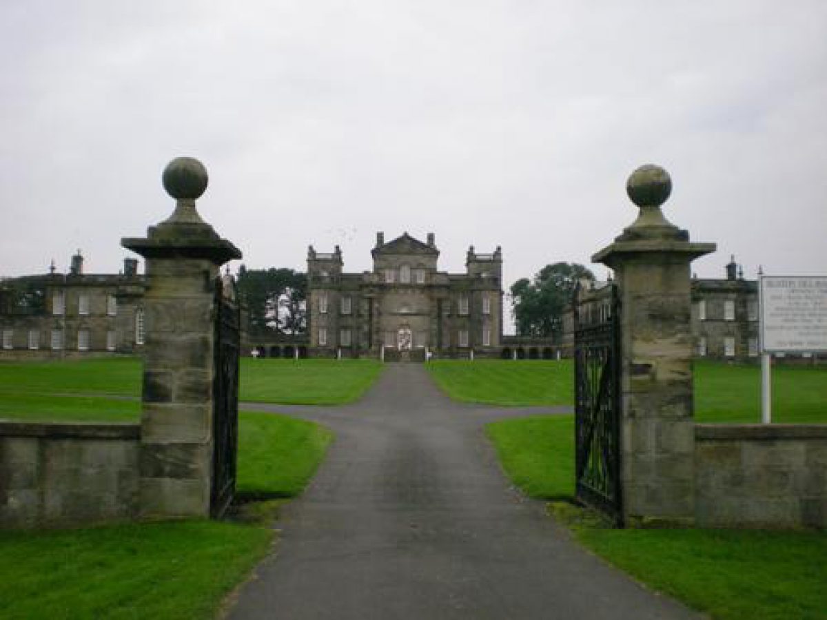
The main entrance to the Hall is off The Avenue which runs north-east from Seaton Delaval village for 1.8 km, crossing the railway line, with an obelisk base (C18, listed grade II) standing c 600 m south-west of the Hall, to the north of The Avenue. Some 200 m south-west of the Hall The Avenue curves sharply north and east to arrive at the main gates (C18, gates renewed C20, listed grade II), standing 100 m north-west of the Hall and aligned with the north-west, entrance front. From the main gates an axial gravel path, flanked by lawns, leads up a slope to the forecourt on the north-west front, which is enclosed on three sides by elements of the Hall. From the main gates The Avenue continues north-eastwards to the village of Seaton Sluice.
Principal Building
Seaton Delaval Hall (1728, listed grade I) stands towards the centre of the site. It is built of ashlar with varying rustication, and has slate roofs. The central part of the building has six bays and three storeys with flanking canted two-storey towers which, together with the west and east wings, enclose the forecourt to the north-west on three sides. The south-east (garden) front has a large portico which gives access from the central garden door onto a broad flight of steps, leading down to the lawns below. The Hall is sited midway along the north-west edge of a rectangular platform, 350 m by 225 m, which is largely enclosed by a ha-ha or ditch (early C18, listed grade II) with angle bastions.
Designed by Sir John Vanbrugh in 1719 for Admiral Delaval, the Hall was completed for his successor Captain Francis Delaval in 1728. The Admiral had intended to alter the old house, which was in a bad state of repair, but after a visit from Vanbrugh he decided to build a new house (CL 1923). The old house, demolished in 1720, was a Tudor manor house adjoining a tower, probably C14, which was enlarged into a large Jacobean mansion (guidebook). Leland (Chandler 1993) mentions Delaval Castle c 1539 as being a mile from the coast. An OS map of 1860 marks the 'supposed site of the Castle' as being south-west of the Church of Our Lady and east of the south-western ha-ha.
The stables occupy the north-east wing. The Coach House, built of square tooled stone, with attached yard walls (early C18, listed grade II), stands to the east of the north-east wing. The south-west wing now (2000) contains domestic accommodation.
A short path leads between two finial-topped gate piers to the Privy House (early C18, listed grade II). Standing 30 m east of the north-east wing and set behind a stone wall, the Privy House is built in Palladian style of square tooled stone. Close by, 100 m east of the Hall, is the Icehouse (probably C18, listed grade II) with a front wall of squared stone with a wooden door, and grassed earth mound to the rear. Farm buildings (C18, listed grade II) 150 m north-east of the Hall are built of coursed squared stone.
Gardens and Pleasure Grounds
The fortified gardens to the Hall, built 1719-28, are enclosed within the ha-ha on the south-west, south-east, and north-east sides, and part of the north-west side, with the Hall forming the remainder of the north-west boundary. Set at the four corners are semicircular bastions.
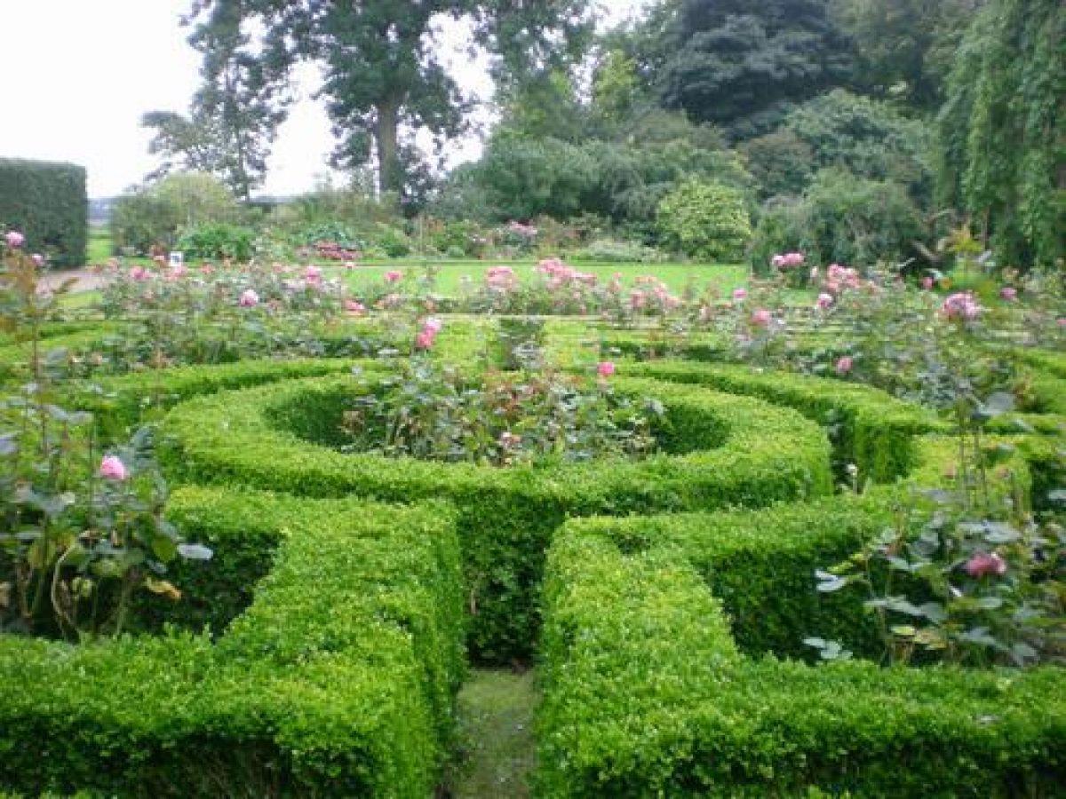
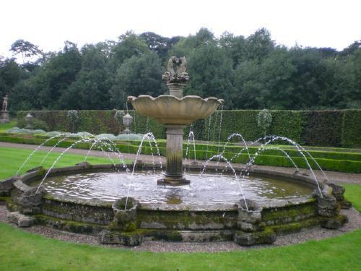
The main gardens now (2000) lie south-west of the Hall. From a gravel path outside the south-west wing the garden is entered through ornamental iron gates surmounted by a coat of arms brought in from Melton Constable (qv), Norfolk in the mid C20. The gates are flanked by low railings. Beyond, to the south-west lies a rectangular garden laid out as a parterre by James Russell in 1950. This garden is enclosed by the ha-ha to the north-west and south-west, with a semicircular bastion standing in the west corner. At the north-east end stands an upper grassed terrace from which two flights of stone steps on either side of the terrace balustrade lead south-west down to the larger, lower terrace, hedged on the north-west and south-east sides. Gravel paths lead south-westwards across the lower terrace on either side of a lawn with a central fountain and box-edged parterres at the south-west and north-east ends. On either side of the gravel paths are long narrow parterres. Between the outer hedges and the parterres are lines of square, clipped yews.
Between the south-east side of the enclosed rectangular garden and the central block of the Hall, to the east, are a series of smaller gardens. Abutting the south-east front of the south-west wing of the Hall is a parterre rose garden. South-east of the rose garden is a semicircular lawn with a mature weeping ash in the centre. Surrounding the lawn is a gravel path and lying to the south-east, herbaceous and shrub borders. South-west of the rose garden is a grassed and hedged enclosure with a central square pond edged with paving designed in the late C20. At the south-west end of the garden the hedges have been cut away to reveal a small wooden summerhouse with a pyramidal roof. Beyond the hedged enclosure is a laburnum walk, also late C20, terminated by an ironwork pergola covered with climbers set in a circular brick-paved area.
The steps from the portico on the south-east front of the Hall lead down to a gravel path crossing the lawn parallel to the Hall. Beyond the gravel path the lawn runs south-east to iron fencing and beyond that, 150m south-east of the Hall, the ha-ha dividing the garden platform from the fields beyond. The area lying south-east of the Hall is now (2000) grazed.
The Church of Our Lady (early C12, listed grade I), built of squared stone with slate roofs, stands 100m south-west of the Hall. This was the family's private chapel until the 1890s. The church is approached by a drive south-east off The Avenue between gate piers (early C18 and C19, listed grade II).
Kitchen Garden
The c 1.5 ha walled kitchen garden (C18, listed grade II) lies c 150m north-east of the Hall. Set into the north-west wall is the Orangery (early C18, listed grade II*), possibly designed by Vanbrugh. It has a Roman Doric arcaded five-bay front with semicircular windows and a central door. South-west of the Orangery is the early C20 gardener's cottage and north-east of the Orangery is a C20 lean-to greenhouse, all the buildings being divided from the main garden by a wooden fence. A further fence runs south-east to the boundary wall, separating the south-west side used for grazing from the north-east side planted with fruit trees. A small pond in the centre of the kitchen garden is enclosed by a fence. The rounded wall of the north-east bastion impinges on the south-west boundary of the garden. Seaton Cottage (early C18 and later, listed grade II) stands at the south-east corner of the garden, flanked to the north-east and south-west by screen walls, and overlooking a small square garden to the south-east.
In 1923, the Orangery is shown with stone dancing putti on the roof (CL 1923). These have now (2000) been moved to a wall within the ha-ha. On the 1860 OS map the garden was laid out in square and rectangular compartments edged by trees.
Park
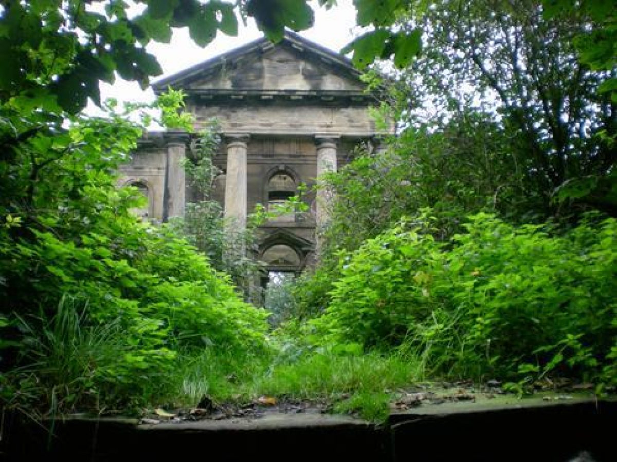
The area beyond the gardens, east of the Hall and ha-ha, is arable land. Running along the south-east boundary of this land is the Sea Walk which passes the Mausoleum (1766, listed grade II*), standing 350m from the east bastion of the garden platform. The Mausoleum is built of ashlar to a cruciform plan, and is surrounded by a circular ha-ha (probably 1766, listed grade II). The west elevation has a pedimented tetrastyle Roman Doric portico with central bow on the east elevation. The Mausoleum, built presumably for Sir Francis Delaval who died in 1771, appears not to have been used, as traditionally Sir John Delaval could not agree with Bishop of Durham over a fee for its consecration (LB description).
Continuing north-eastwards from the Mausoleum the Sea Walk leads to the village of Seaton Sluice. The Walk runs through a narrow band of woodland planted mainly with sycamore. The end of the path, c 1.1km east of the Hall, is marked by a small gate (now, 2000, disused) in a wall dividing the Walk and the C20 housing of Seaton Sluice village. The natural harbour of the village was used for the export of coal and salt but silted up. A sluice was built by Sir Ralph Delaval in the 1660s giving the village its name. Charles II appointed Sir Ralph Collector and Surveyor of his own port (CL 1923).
An axial link may be seen linking the Hall with the Obelisk (C18, listed grade II), standing 900 m to the south-east, the Egg Pond, lying 450 m to the south-east of the Hall (outside the area here registered), and the site of fishponds, now (2000) gone, formerly c 300 north-west of the Hall and also beyond the area here registered. These may be the remains of a formal C18 layout. North-east of the obelisk is Obelisk Plantation.
Admiral Delaval, in a letter to his brother of c 1717, mentions planting avenues (CL 1923).
Maps
- OS 6" to 1 mile: 1924 edition
- OS 25" to 1 mile: 1st edition published 1860
Description written: September 2000
Amended: April 2001
Edited: July 2003
- Visitor Access, Directions & Contacts
Access contact details
The site is open from Friday to Monday between April and December. Please see: http://www.nationaltrust.org.u...
Owners
The National Trust
Heelis, Kemble Drive, Swindon, SN2 2NA
- History
The following is from the Register of Parks and Gardens of Special Historic Interest. For the most up-to-date Register entry, please visit The National Heritage List for England (NHLE):
12th Century
Seaton Delaval was owned by the de la Val family from the early 12th century. The old village of Seaton Delaval which lay close to the church disappeared gradually some time after 1311.
17th - 18th Century
By 1628, there were no remaining houses, but there was a flock of 1300 sheep (Beresford 1965).
In 1628, Sir Ralph Delaval (1622-91) inherited and in 1660 was created a baronet. His eldest son, also Sir Ralph, died in 1696 without a male heir and his second son, Sir John Delaval, inherited. Sir John was obliged to sell the estate to his cousin, Admiral George Delaval, who from 1718 began building a new house at Seaton Delaval, designed by Sir John Vanbrugh (1664-1726), but died in 1723. His nephew, Captain Francis Delaval (1692-1752), inherited Seaton Delaval, having already inherited Ford Castle, Northumberland, from his mother in 1711. He married Rhoda Apreece, heiress to Doddington Hall (see description of this site elsewhere in the Register) in Lincolnshire. The building of Seaton Delaval was completed in 1728.
19th Century
A fire in the Hall in 1822 rendered the main block uninhabitable (Country Life 1923). During both the First and Second World Wars the Hall was requisitioned. Restoration of the Hall has taken place since 1950. The Hall and the estate continue (2000) in private ownership.
- Associated People
- Features & Designations
Designations
The National Heritage List for England: Register of Parks and Gardens
- Reference: GD2054
- Grade: II*
Features
- Statue
- Topiary
- Pool
- Fountain
- Ha-ha
- Avenue
- Walk
- Description: Sea Walk which connects the site with the village of Seaton Sluice.
- Plantation
- Description: Obelisk Plantation.
- Obelisk
- Hall (featured building)
- Description: Seaton Delaval Hall (1728, listed grade I) Designed by Sir John Vanbrugh
- Earliest Date:
- Latest Date:
- Coach House
- Description: The Coach House, (early C18, listed grade II),
- Privy House
- Description: Privy House (early C18, listed grade II).
- Icehouse
- Description: Icehouse (probably C18, listed grade II)
- Gardens
- Description: The fortified gardens to the Hall, built 1719-28, The main gardens now lie south-west of the Hall.
- Church
- Description: The Church of Our Lady (early C12, listed grade I), which was the family's private chapel until the 1890s.
- Mausoleum
- Description: Mausoleum (1766, listed grade II*), built of ashlar to a cruciform plan
- Kitchen Garden
- Description: c 1.5ha walled kitchen garden (C18, listed grade II)
- Key Information
Type
Garden
Purpose
Ornamental
Principal Building
Domestic / Residential
Survival
Extant
Hectares
22
Open to the public
Yes
Electoral Ward
Seaton Delaval
- References
References
- White, S., {Gardens of Northumberland and the Borders} (Cramlington: Sanderson Books Limited, 2006), pp. 170-7 Gardens of Northumberland and the Borders
- {English Heritage Register of Parks and Gardens of Special Historic Interest}, (Swindon: English Heritage, 2008) [on CD-ROM] Historic England Register of Parks and Gardens of Special Historic Interest
- Pevsner, N., J. Grundy and I. Richmond, {The Buildings of England: Northumberland} (London: Penguin, 1992) The Buildings of England: Northumberland
- pp 57, 60, plates 35-37 Sir John Vanbrugh and Landscape Architecture in Baroque England 1690-1730
- (8 December 1923), pp 800-08; (15 December 1923), pp 860-8; 107 (2 June 1950), pp 1648-52 Country Life, 54
- Sir John Vanbrugh, Architect and Dramatist
- An Atlas of Tudor England and Wales, Forty Plates from John Speed's Pocket Atlas of 1627
- (5th impression 1965), pp 172-3 The Lost Villages of England
- guidebook, (1966) Seaton Delaval Hall, Northumberland, guidebook
- John Leland's Itinerary, Travels in Tudor England