Introduction
Queens' College has small gardens and pleasure grounds (about 4 hectares), much of which have been lost due to the extension of the modern college buildings. Of particular note is the world famous 'Mathematical Bridge', which was built in 1749 by James Essex. It is constructed purely by pegging the timbers together.
Terrain
Flat.Logan’s map of 1960 shows the Principal's Garden divided in to four plots enclosed by a wall with trained fruit trees and a summerhouse overlooking the river. The Fellows' Garden is shown with two plots edged with shrubs and a summer house in the corner. From the Fellows' Garden access was possible to the bowling green.
The following is from the Register of Parks and Gardens of Special Historic Interest. For the most up-to-date Register entry, please visit the The National Heritage List for England (NHLE):
www.historicengland.org.uk/listing/the-list
College courts, landscaped pleasure grounds and gardens, laid out between the 16th and the 20th century.
LOCATION, AREA, BOUNDARIES, LANDFORM, SETTING
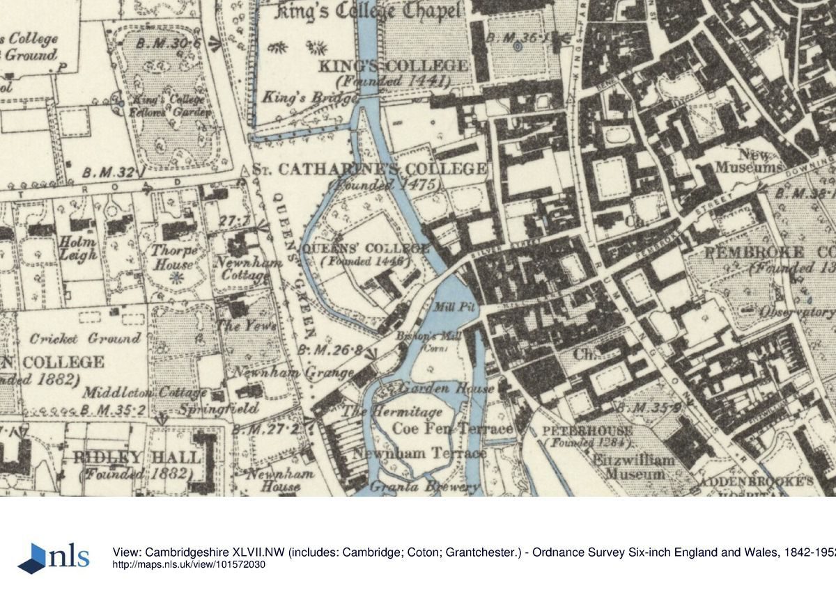
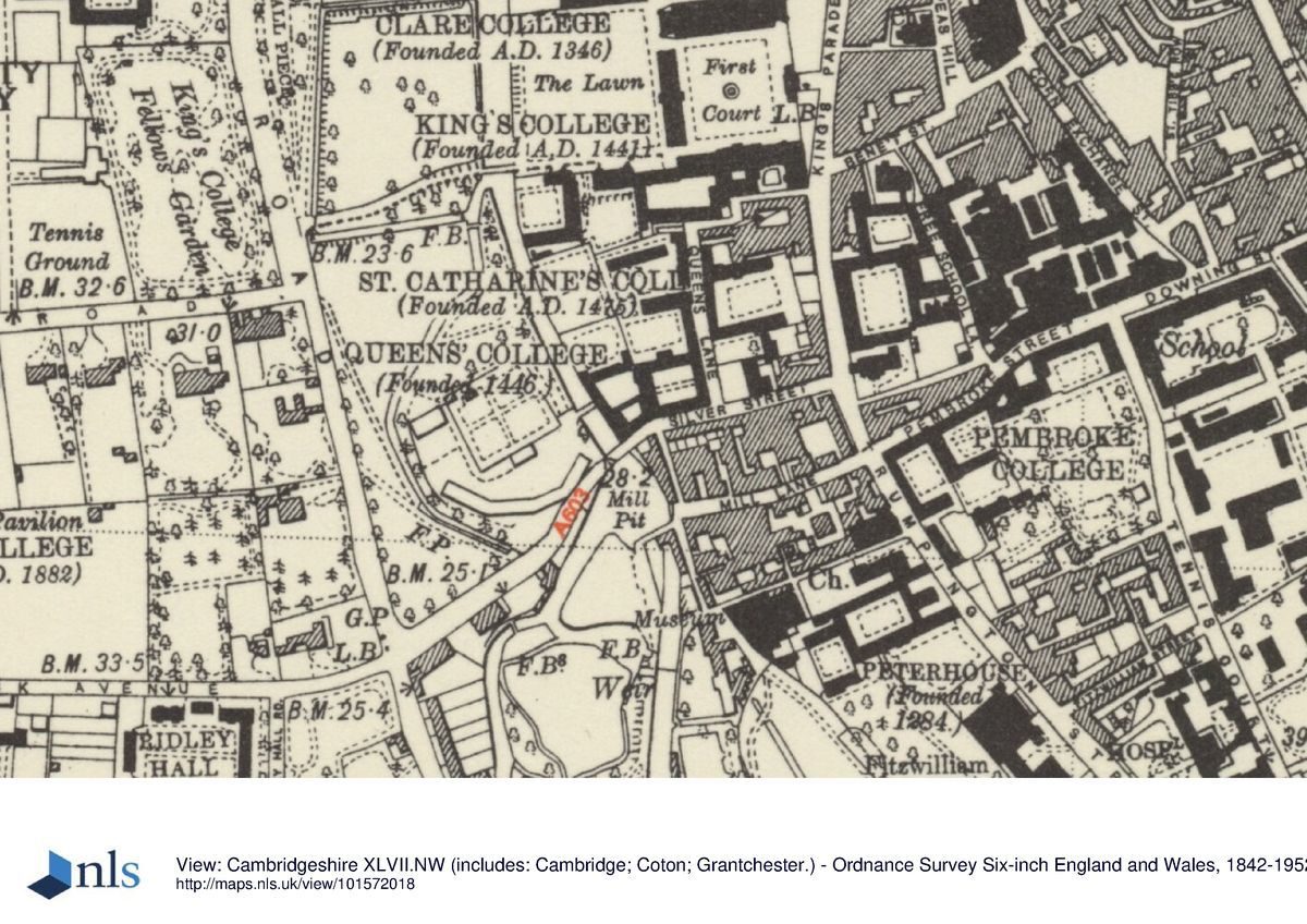
Queens' College lies at the centre of Cambridge, on flat ground crossed by the River Cam and various drainage ditches. The c 4ha site is bounded to the north by King's College (qv), to the east by Queens' Lane and beyond this St Catharine's College and the city centre, to the south by Silver Street, and to the west by Queens' Road. Queens' College forms the southernmost of a group of city-centre colleges, cut from north to south by the river and Queens' Road, the area between these two features forming the centre section of the sequence of five adjacent college gardens and meadows which, taken together, are known as The Backs. In 1779 Lancelot Brown (1716-83) provided a plan to landscape The Backs, including that part of Queens' College west of the river. He intended to widen the river into a serpentine lake, and remove the boundaries between individual college grounds together with King's, Clare and Trinity College bridges, using King's College Gibbs Building as the substitute focal point for a great house. This plan was never carried out and The Backs remain individually owned and designed pleasure grounds and gardens.
ENTRANCES, APPROACHES AND COURTS
The college is approached at its east end, straight off Queens' Lane, via Old Court Gate (gatehouse tower 1518-35), which tower gives access to the east side of Old Court (1440s, listed grade I), one of the best-preserved medieval courts in Cambridge. The brick court contains two rectangular panels of lawn encircled by a perimeter path and divided by a central stone path running west from the gateway to the west range. A colourful sun- and moondial is painted onto the north wall of the court, put up in 1733 to replace an earlier dial in the same position erected in 1642, depicted by Loggan in 1690. A passage through the west range emerges into the south-east corner of Cloister Court (C15-C17, listed grade I), surrounded on three sides by brick cloisters, and bounded on the fourth, east side by the Hall. The court is laid largely to lawn, divided from west to east by a central stone path, and overlooked by the enclosed cloister walks, with the timber-framed President's Lodge and Gallery (mid/late C16) above the north cloister (late C15). South of Cloister Court lies Pump Court (James Essex mid C18, listed grade I), bounded on the north side by the single-storey cloister of the south side of Cloister Court, and laid largely to stone paving.
A passage through the west range of Cloister Court opens onto Queens', or the Mathematical, Bridge (1906, copied from earlier version of 1749-50 designed by W Etteridge and built by James Essex on the site of an earlier bridge, listed grade II). This single-span, timber, openwork bridge, in Chinese style, gives access to the west side of the river, to a former island (bought by the college 1475) bounded by the river to the east, and a small drain to the west and north, on which stand the curved, brick Fisher Building (1935-6) and square, concrete Cripps Court (Powell & Moya 1972-90s). From the west side of the bridge a gravel path leads north along the west bank of the river to the northern tip of the island, overlooking the Master's and Fellows' Gardens on the east bank. The northern section of the island, the Grove, is planted with mature deciduous trees enclosing a short, mature beech avenue aligned on the Fellows' Garden to the east, encircled by an informal perimeter path, with views extending north towards King's College Bridge and grounds (qv) and Clare College and Bridge (qv) beyond. The south side of the Grove is bounded by a brick wall (C18/C19, listed grade II) separating it from Cripps Court immediately to the south. This wall formed the north side of the square Fellows' Fruit Garden which was replaced in the 1970s by the Cripps Building. An enclosed square garden appears to have survived on the site of this walled garden from the C16 (Lyne, 1574; Loggan, 1688), by the early C20 (OS 1925) divided into quarters by cruciform paths, surrounded by a perimeter path. In the C15 the Grove was reached from the gardens on the east bank by a small bridge, which arrangement continued into the late C17, when the Grove was thickly planted with trees and pathless. The bridge was removed in 1793 (Scarr 1983). Between 1749, following the erection of Essex's bridge, and 1752, John Forlin, the college gardener, made various alterations in the Grove, which was still thickly planted with trees, probably thinning trees and laying out paths (Architectural Review 1947).
A passage through the north range of Old Court gives onto Walnut Tree Court (C17-C19, listed grade I), laid largely to lawn, on which stands a specimen walnut tree (planted 1930, replacing earlier specimens), bounded by a perimeter path and dominated on the north side by the New Chapel (G F Bodley 1889-91, listed grade I). The west boundary is formed by the east range of the President's Lodge and, extending north from this, the east wall of the President's Garden (C18, white brick, listed grade II). At the north end of this wall, in the north-west corner of Walnut Tree Court, stands a small, square, brick enclosure with brick paving, once roofed (Loggan 1690). This structure facilitated access between the four garden compartments which met here in order that the Fellows might have access between the north-west and south-east compartments (bowling green and sundial garden, and the garden now covered by Walnut Tree Court, respectively) without trespassing on the Master's gardens to the north-east (now Friar's Court) and south-west, and vice versa, so that the Master did not trespass on the Fellows' gardens.
West of the New Chapel, Walnut Tree Court gives onto Friar's Court to the north, laid principally to lawn with a perimeter path, surrounded largely by late C19/C20 brick buildings. The west range is formed by the Erasmus Building (B Spence 1959/60), a large brick and concrete L-shaped range standing on stilts, with an open ground floor, forming the boundary between this court and the Fellows' Garden to the west.
GARDENS
The Fellows' Garden lies against the north boundary with King's College, marked by a stone wall (probably 1551, listed grade II), and is reached from the north-west corner of Walnut Tree Court. The area, bounded to the west by the river, to the south by the President's Garden (separated by a brick wall), and to the east by the Erasmus Building, is divided into two halves. The northern half contains a crown bowling green/croquet lawn, and the southern half, at a slightly higher level, a lawn informally planted with specimen trees and shrubs. The Garden is surrounded by a perimeter gravel path, and overlooks the Grove to the west of the river, with views extending north towards King's Bridge and grounds beyond, with Clare Bridge in the distance.
The Fellows' Garden appears to have been enclosed as a garden since at least the mid C16 (Lyne, 1574). By the late C17 (Loggan, 1688, 1690) the bowling green was in existence, with a small garden building at its north-west corner, divided from the southern half of the garden by a hedge. The southern half was divided into two small, formally laid out sections, divided from north to south by a path and surrounded by a perimeter path. The east section was laid out as a sundial, with the hour sections marked on the ground, seemingly using plants, at the south side of which stood a large gnomon. The whole Garden was surrounded by walls, including one above the river, at the north end of which stood a doorway giving access to the bridge and the Grove beyond. The bowling green has altered little since this time. A formal arrangement continued in the southern half until at least the late C18 (Custance, 1798), but by the late C19 (OS 1888) the area had been planted informally with trees and shrubs, although retaining the perimeter path around the Garden.
The President's Garden is bounded to the north and east by a brick wall (C18, listed grade II), beyond which lie the Fellows' Garden and Walnut Court respectively, to the west by the river, and to the south by the timber-framed President's Lodge, forming the north range of Cloister Court. The Garden is laid to lawn surrounded by informal tree and shrub planting, with a perimeter path. The lawn is divided from the river by a dense shrubbery, below which, adjacent to the river, runs a path at a lower level, bounded by iron railings standing on top of the riverside wall, with an iron water gate at the south end.
The President's Garden enclosure seems to have been in existence since at least the mid C16 (Lyne, 1574). By the late C17 (Loggan, 1688) it was enclosed by walls on all but the south side (bounded by the Lodge), with a small building straddling the riverside wall at the north end. The interior was laid to four ornamental quarters divided by paths, although this Garden was not laid out as elaborately as the adjacent Fellows' Garden. In the late C19 the Garden had assumed an informal layout similar to that today (1998), with perimeter planting and island beds, and a serpentine perimeter path.
OTHER LAND
West of the island on which the Grove stands lies Queens' Green, an open area of grass crossed diagonally by a path from the north-west corner, bounded to the north and east by drains, to the west by Queens' Road, and to the south by Silver Street. Currently a public open space which is registered common land, it is enclosed to the west, north and south by a line of lime trees. It forms part of the open area known as The Backs and extends south from King's College's meadow (Scholars' Piece), being divided from it by a drain. It has remained open space since the C16 (Lyne, 1574) and by the late C17 was known as Queens' College Green, bounded along the drain to the east by a line of trees, and reached from the north tip of the Grove by two small bridges. A bridge seems to have continued on this site until the early C20 (Custance, 1798; OS 1888, 1925).
REFERENCES
Loggan, Cantabrigia Illustrata (1690)
Beeverell, Les Delices de la Grand Bretagne ... (1707)
Country Life, 27 (12 February 1910), pp 239(42; 69 (21 February 1931), pp 222-8; (28 February 1931), pp 262-8; (7 March 1931), pp 290-6
Architectural Review 50, no 601 (January 1947), pp 13-18
Roy Comm Hist Monuments of Engl Inventories: Cambridge 2, (1952), pp 177-8
Victoria History of the County of Cambridgeshire III, (1959), pp 408-14
N Pevsner, The Buildings of England: Cambridgeshire (1970), pp 134-40
L P Wilkinson, Le Keux's Engravings of Victorian Cambridge (1981)
M M Scarr, Queens' College, Cambridge (1983)
R Gray, Cambridge Colleges (1984), pp 49-50
M Batey, The Historic Gardens of Oxford and Cambridge (1989), pp 20, 23, 38, 40, 48, 121-2, 124, 168, 178
Maps
Lyne, Map of Cambridge, 1574
Loggan, Map of Cambridge, 1688 (from Cantabrigia Illustrata, 1690)
Custance, Map of Cambridge, 1798
Baker, Map of Cambridge, 1830
OS 25" to 1 mile: 3rd edition published 1925
OS 1:500: 1st edition published 1888
Description written: February 1998
Register Inspector: SR
Edited: January 2001
- Visitor Access, Directions & Contacts
Access contact details
The site has variable opening hours. Please see: http://www.queens.cam.ac.uk/general-information/tourist-information
Directions
Central Cambridge.
- History
The college was founded in 1446 and unusually again in 1448 by Margaret of Anjou and again in 1465 by Elizabeth Woodville.
The following is from the Register of Parks and Gardens of Special Historic Interest. For the most up-to-date Register entry, please visit the The National Heritage List for England (NHLE):
www.historicengland.org.uk/listing/the-list
HISTORIC DEVELOPMENT
Queens' College was founded three times between 1446 and 1475 by Andrew Docket, Rector of St Botolph's and Principal of St Bernard's Hostel. At the second foundation, in 1448, Margaret of Anjou, queen of Henry VI, became patron, and in 1465 Elizabeth Woodville, Edward VI's queen, became patron. Richard III's queen, Anne Neville, was the third patron in the late 15th century. It is possible that the first architect, who may have designed Old Court and parts of Cloister Court, was Reginald Ely, Henry VI's architect for King's College and Eton College. Building continued from the 15th century to the 20th century, largely centred around the 15th century Old Court and 15th/16th century Cloister Court. The site remains (1998) in college use.
Period
- Post Medieval (1540 to 1901)
- Tudor (1485-1603)
- Associated People
- Features & Designations
Designations
The National Heritage List for England: Register of Parks and Gardens
- Reference: GD1621
- Grade: II
Features
- College (featured building)
- Earliest Date:
- Latest Date:
- Ornamental Bridge
- Description: The Mathematical Bridge has been replaced twice to the same design in 1866 and 1905.
- Earliest Date:
- Latest Date:
- Key Information
Type
Garden
Purpose
Recreational/sport
Principal Building
Education
Period
Post Medieval (1540 to 1901)
Survival
Extant
Hectares
4
Open to the public
Yes
- References
References
- Cambridgeshire Gardens Trust {The Gardens of Cambridgeshire} pp 7-8 The Gardens of Cambridgeshire
- Pevsner, N {The Buildings of England: Cambridgeshire} (Harmondsworth: Penguin, 1970) pp 134-140 The Buildings of England: Cambridgeshire
- Batey, M., {The Historic Gardens of Oxford and Cambridge} (London: Macmillan London, 1989) The Historic Gardens of Oxford and Cambridge