
Introduction
Pishiobury has the remnants of an 18th-century landscape park, re-designed by Lancelot Brown. At its most extensive the site covered about 100 hectares. The present parkland and agricultural land around the house covers about 17 hectares. Features include an oak walk and a lodge.
Terrain
The southern half of the site is largely level, although the ground slopes gently south-east down from house towards the river.www.historicengland.org.uk/listing/the-list
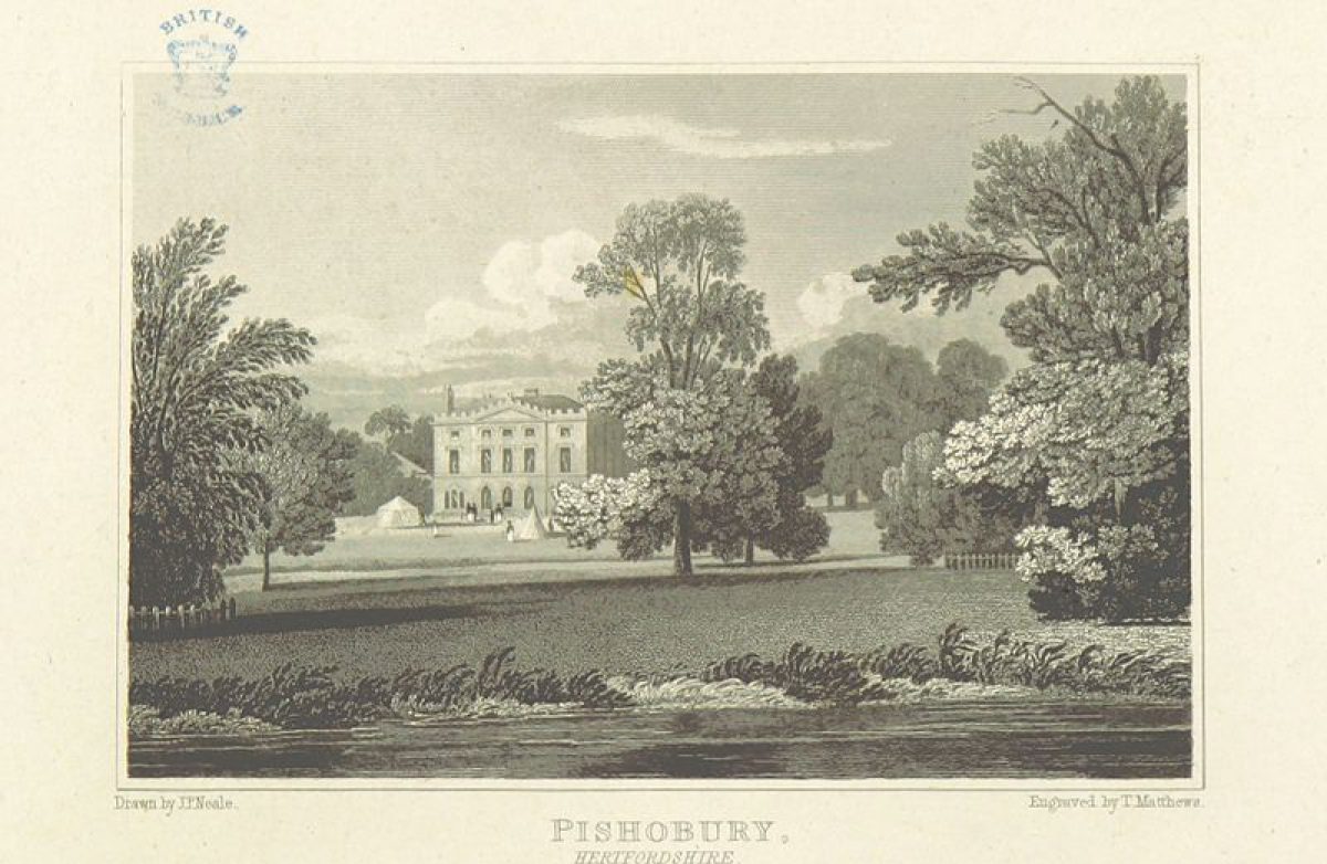
A country house surrounded by a landscape park attributed to Lancelot Brown (1782-3), with C16 and later gardens including formal canals.
DESCRIPTION
LOCATION, AREA, BOUNDARIES, LANDFORM, SETTING
Pishiobury lies close to the north-east suburbs of Harlow (Essex), at the south end of the village of Sawbridgeworth, on the east boundary of Hertfordshire. The c 65ha site is bounded to the north-west by the A414 Harlow to Bishop's Stortford road, and on the other sides by agricultural land, woodland and flood meadows. The south-east boundary is marked by the River Stort (Navigation). The southern half of the site is largely level, although the ground slopes gently south-east down from house towards the curving course of the serpentine arm of the river, broadened in the late C18. The undulating northern half is dominated by the crest of the broad spine of land running from north-east to south-east which is occupied by the Oak Walk.
The setting is partly rural, with the C20 development of Sawbridgeworth adjacent to the north. An area of agricultural land, outside the area here registered and formerly part of the estate, lies adjacent to the south-west, forming a buffer between the park and the north-east edge of Harlow. Formerly, Rowney Lodge, a small, single-storey brick lodge which stands 900m west of the house on the A414, gave access to a south-west drive (gone, 1999) which crossed this area eastwards, extending along the south side of Union Wood to cross the park to the north-east and join the east end of the west drive (OS 1880).
ENTRANCES AND APPROACHES
The main approach to the house enters off the A414, 700m north-west of the house, the gateway being set back a little, off the road. A single-storey, red-brick, Tudor-style lodge (c 1840, listed grade II) stands to the north of the gateway (C18, listed grade II), where two tall, stone piers flank the entrance to the west drive. From here the straight drive extends south-east, flanked by a horse-chestnut avenue set in mown grass, this in turn flanked by the front gardens of C20 houses which line the drive (excluded from the area here registered). The drive turns east 100m from the house to arrive at a tarmac carriage sweep on the west front, overlooking a large paddock to the north-west which is enclosed by trees and hedgerows, from which the forecourt is separated by a brick ha-ha. From the forecourt, a drive curves around the north and east fronts of the house, giving access to C20 houses built in the service areas south of the house.
The former north drive, known as Oak Walk (disused, 1999), entered via the north-east boundary, 750m north of the house, through a belt of trees known as Nursery Wood. The remains of the drive, now a footpath, curve south across the high ground of the northern half of the park, flanked by an avenue mainly of oaks with some limes, starting to descend to the south 500m from the house, to join the west drive 100m north-west of the house. Panoramic views extend north-east, east and south from various parts of the northern half of the Oak Walk and the ground to the east.
PRINCIPAL BUILDING
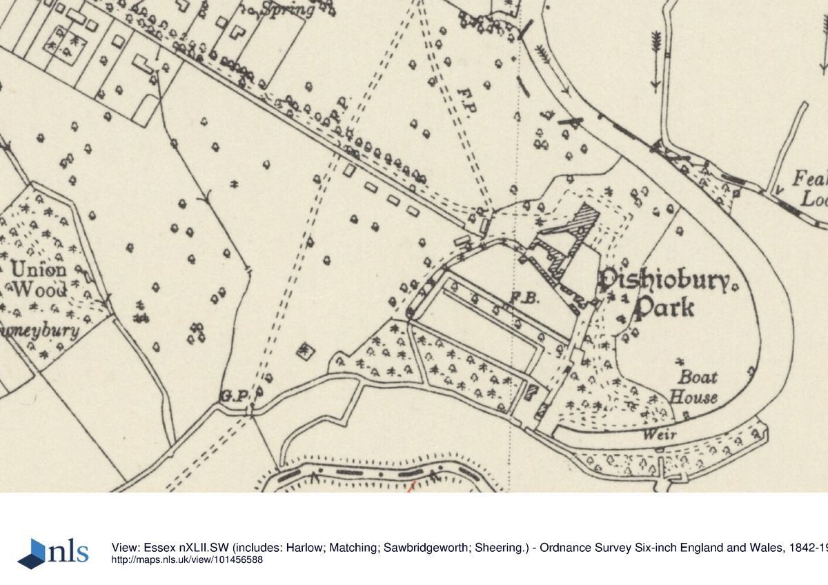
Pishiobury Park house (late C16, rebuilt 1782-4 by James Wyatt, listed grade II*) stands towards the south-east corner of the site, overlooking the broadened arm of the River Stort which encloses it and its pleasure grounds on three sides, and beyond this to the east the River Stort (Navigation) and associated water meadows. The two-and-half-storey, Gothic Revival house is built of red brick with stucco details. An office range stands attached to the south side of the house, overlooking the upper courtyard beyond, the east side of which is closed by an C18 red-brick dairy (listed grade II). On the south side of the upper courtyard stands the stable block (late C16, listed grade II*), overlooking the lower courtyard to the south. An C18 timber-framed barn (listed grade II) stands at the east side of the lower courtyard. All these buildings have been converted to domestic use (late 1990s).
GARDENS AND PLEASURE GROUNDS
The gardens and pleasure grounds bound the house to the east and south. Two garden doors, situated at either end of the east front, open onto a stone-flagged terrace, at the centre of which a short flight of steps gives access to a level lawn below. The lawn is bounded on the east side by the extension of the drive giving access to the service area developments, running along the top of a low grass terrace, at the centre of which a short flight of stone steps gives access to the east lawn beyond, formerly part of the parkland but now (1999) part of the pleasure grounds. The east lawn is bounded to the north, east and south by the broadened arm of the river, and is planted with large swathes of shrubs and immature specimen trees. A large cedar stands on the west side. Views extend east from the east front and the terraces across the lawn to the distant countryside, although the broad river arm is (1999) largely obscured by vegetation. The south-west corner of the east lawn is bounded by a wooded area of former pleasure ground, which is bounded to the south by the broad river arm and to the west by the former service areas and kitchen gardens.
PARK
The park is divided into two main sections, the lower, southern half, and the higher, undulating northern half, dominated by the spur of land carrying Oak Walk. The southern half is (1999) divided into several sections, including the paddock west of the house, the area south of the west drive development, and the area north of the west drive development which is bounded to the north by a line of mature lime trees. This line of limes marks the line of a former avenue which linked the southern end of the oak avenue with the main road to the west. The northern half is laid largely to pasture with scattered mature trees and hedgerows, with views east towards a distant partly wooded hillside. The sinuous, crescent-shaped arm of the river running through the east side of the park is largely obscured from the park by vegetation. It was broadened and shaped in the late C18, probably to designs by Lancelot Brown (Stroud 1975).
KITCHEN GARDEN
The brick-walled kitchen gardens (C18, listed grade II) lie south and east of the house service buildings, and are divided into two main sections. The north-east compartment is bounded by brick walls, its south-east corner being marked by a single-storey, brick summerhouse with a pyramidal roof (c C16, converted to domestic accommodation, listed grade II with the walls). The garden is entered from the main garden terraces via a gateway set into the north wall. From here a path leads south flanked by late C20 brick garden walls which are related to C20 domestic accommodation adjacent to the original garden walls. The path emerges onto a lawn occupying the southern half of the compartment. A gateway in the south wall of this compartment gives access to the former L-shaped glasshouse yard dividing this compartment from the larger southern kitchen garden compartment beyond (OS C19). To the west of the north-east compartment lies the lower courtyard.
The brick walls of the southern area encompass three sides of the compartment, leaving the fourth, south-west side open, bounded by a broad canal and overlooking an area of woodland beyond. The garden is divided from the woodland by a rectangular open area enclosed by further canals. The C18, two-storey, former gardener's house (listed with the walls) stands set into the north side of the wall. Built of red brick, with a steep, tiled roof, it is flanked by late C20 houses built along the outer side of the garden wall. The kitchen garden is laid largely to lawn, divided from north-east to south-west by a central brick wall, and incorporated into the gardens of the adjacent houses.
REFERENCES
Chauncy, Historical Antiquities of Hertfordshire (1700), p 179
Victoria History of the County of Hertfordshire 3, (1912), pp 336-8
D Stroud, Capability Brown (1975), p 236
B Cherry and N Pevsner, The Buildings of England: Hertfordshire (1977), p 271
J Harris, The Artist and the Country House (1979), p 110
Maps
Dury and Andrews, A topographical Map of Hartford-shire, 1766
A Bryant, The County of Hertford, 1822
Tithe map for Sawbridgeworth parish, 1839 (Hertfordshire Record Office)
Pishiobury Park Sale particulars, c 1844 (Hertfordshire Record Office)
Pishiobury Park Sale particulars, c 1865 (Hertfordshire Record Office)
OS 6" to 1 mile:
1st edition published 1880
2nd edition published 1899
3rd edition published 1925
OS 25" to 1 mile:
1st edition published 1889
2nd edition published 1898
Description written: September 1999
Register Inspector: SR
Edited: October 2000
- Visitor Access, Directions & Contacts
Telephone
01279 655261Access contact details
This is a municipal park for general public use.
Directions
South east of Sawbridgeworth
Owners
East Hertfordshire District Council
Wallfields, Pegs Lane, Hertford, SG13 8EQ
- History
The following is from the Register of Parks and Gardens of Special Historic Interest. For the most up-to-date Register entry, please visit the The National Heritage List for England (NHLE):
www.historicengland.org.uk/listing/the-list
HISTORIC DEVELOPMENT
Sir Walter Mildmay (d 1606/7) acquired the manor of Pishobury and the associated park by 1576 (VCH), and rebuilt the manor house c 1585. The estate was sold by the family in 1611 to Lionel Cranfield, Earl of Middlesex, for whom Inigo Jones designed the porch and other alterations in 1615 (Harris 1979). By 1700 the estate comprised, according to Chauncy:
A very neat and fair pile of building for the Mannor House upon a rising ground in the vale near the River Stort, which courses about 20 acres of ground on the East side of the house, lately converted into a paddock for deer, adorned in front thereof with a fair bowling green raised about 5 foot high enclosed with a brick wall topped with stone balls upon it and 2 fair walks planted with trees, each walk extending about 4 furlongs in length from the house to the road.
The engraving accompanying this description depicts a walled forecourt on the west, entrance front of the house, with a pavilion set into the north-east corner of the forecourt. The ground beyond to the west, in which stands a tree house, is also planted with an avenue leading to the entrance to the forecourt, and fishermen stand to the north on the river bank.
By 1766 (Dury and Andrews) the park had been laid out formally with four avenues of trees, and several rectangular enclosures around the house, and possibly kitchen gardens on the site of the present kitchen garden (see below). Shortly after this the house was destroyed by fire, and rebuilt on the same site c 1782-4 by Jeremiah Miles, under the direction of James Wyatt. At the same time Lancelot Brown (1716-83) may also have been called in to work on the park (Stroud 1975). He is reputed to have removed some of the avenues and supervised the construction of the lake, but probably did not have any great involvement in carrying out the works as he died in 1783.
A sale plan of c 1844 shows the landscape park, enclosed to the north and west by belts, and to the east by the sinuous lake, but retaining the remains of avenue planting, particularly along the two main drives. The layout of the grounds remained much the same during the rest of the C19, and into the C20 when the estate (which had become known as Pishiobury in the mid to late C19) was sold into divided ownership. Areas along the west boundary, flanking the west drive and around the kitchen gardens, have been the subject of housing development.
Period
18th Century (1701 to 1800)
- Associated People
- Features & Designations
Designations
The National Heritage List for England: Register of Parks and Gardens
- Reference: GD1125
- Grade: II
Features
- House (featured building)
- Description: There was a manor house on the site, which was re-built in 1585 and altered thereafter. It was destroyed by fire in the late-18th century and re-built by Jeremiah Miles, under the direction of James Wyatt.
- Earliest Date:
- Latest Date:
- River
- Description: The south-east boundary is marked by the River Stort (Navigation).
- Walk
- Description: Oak Walk.
- Gate Lodge
- Description: Rowney Lodge, a small, single-storey brick lodge.
- Parkland
- Key Information
Type
Park
Purpose
Recreational/sport
Principal Building
Parks, Gardens And Urban Spaces
Period
18th Century (1701 to 1800)
Survival
Extant
Hectares
65
Open to the public
Yes
Civil Parish
Sawbridgeworth
- References
References
- {English Heritage Register of Parks and Gardens of Special Historic Interest}, (Swindon: English Heritage, 2008) [on CD-ROM] Historic England Register of Parks and Gardens of Special Historic Interest
- Stroud, D., {Capability Brown} (London: Faber, 1975), p. 236 Capability Brown
- Harris, J., {The Artist and the Country House} {London: Russell Chambers, 1979), p. 110 The Artist and the Country House
- Pevsner, N. and B. Cherry, {The Buildings of England: Hertfordshire} (Harmondsworth: Penguin, 1977), p. 271 The Buildings of England: Hertfordshire
- Page, W. {Victoria County History: Hertford, Volume 3} ([n.p.]: [n.pub.], 1912), pp. 336-8 Victoria County History: Hertford, Volume 3
- The Landscape Agency {Pishiobury Park Restoration Plan} (2005) Pishiobury Park Restoration Plan
- {Pishiobury Park Management Plan} (2001) Pishiobury Park Management Plan