Introduction
Peper Harrow is a mid-18th-century landscape park designed by Lancelot ‘Capability’ Brown with buildings by William Chambers and AWN Pugin. Features include a gate lodge, granary, kitchen garden and grade I listed house.
www.historicengland.org.uk/listing/the-list
Summary of Garden
Mid-C18 landscape park designed by Lancelot ‘Capability' Brown with buildings by William Chambers and AWN Pugin. Details
LOCATION, SETTING, LANDFORM, BOUNDARIES, AND AREA
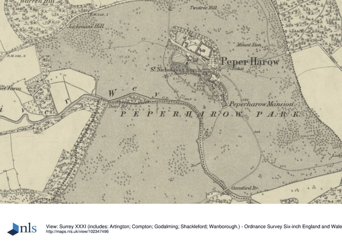
Three hills, Jackman's Hill, Mount Sion and Twotree Hill, form an area of higher ground in the north of the park of Peper Harow. The ground slopes southwards to the River Wey, which crosses the park from west to south-east, with the land south of the river being more low-lying. To the south there are views to Bonville Hanger and more distant views towards the South Downs.
On the east side of the park is a low bank and ditch which marks the parish boundary and was probably the medieval deer pale. Sections of park pale also survive on the north boundary of the park. In the north-east corner are areas designated as Ancient Woodland. The other boundaries are formed by roads, tracks, streams and areas of woodland.
The site encompasses some 150 hectares.
ENTRANCES AND APPROACHES
Oxenford Lodge was designed by Chambers in c1763 (listed Grade II) and stood at the main Oxenford approach at the south of the park. The approach is thought to have been designed by Lancelot Brown with a pond in a setting with the ruined remains of Oxenford Grange (listed Grade II). It is planted with oaks and London Planes. The Oxenford Gate Lodge, granary, barn and farm buildings were added by AWN Pugin in 1843 (all listed at Grade II*).
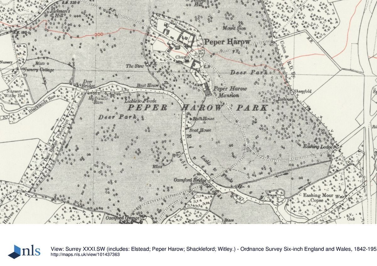
From the lodge a drive, now a grassed track, crosses the river at Oxenford Bridge (listed Grade II and dated to c1813) and continues onto the house. Its course differs very slightly from that on Rocque's map. The original survives as a relict drive passing through the pleasure grounds between the house and the river, crossing the western part where it crossed a deer bridge at the west edge and ran along the western edge of the park near Deer Bridge Plantation, a designated area of Ancient Woodland. The relict pleasure grounds serpentine drive was thought to be Brown's work and traces of it can be seen on an aerial photograph of 2009.
The Charcoal Lodge (the lodge a late C19 addition) stands at the northern approach to the park. A tarmac drive to the house enters the park from the lodge through a deep cutting planted with C18 oaks and this drive continues past Home Farm buildings as a gravel drive to the house.
The Farnham Lodge approach in the north-east corner is shown on the 1873 Ordnance Survey map and might have replaced an earlier serpentine drive shown on Rocque's map. This is now straight and is a grassed track. Farnham Lodge was designed by William Chambers in c1765 (Grade II).
The mid-park eastern approach depicted on the 1873 Ordnance Survey map from Eashing is straight. Another approach, also from Eashing, is marked by Eashing Lodge in the south-east corner. Eashing Lodge was designed by Chambers and dates from the 1760s with later extensions (not listed). This drive joins to the Oxenford grass track drive and continues up to the house.
PRINCIPAL BUILDING
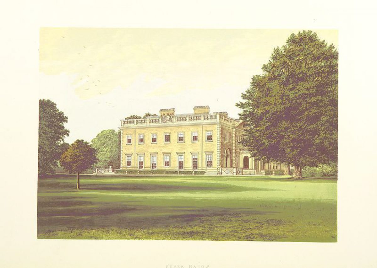
Peper Harow House (listed Grade I) was designed 1765-8 by Sir William Chambers (1722-96) for the Third Viscount Midleton and completed by the Fourth Viscount in 1775-7. It is a plain Italianate building, in brick and stucco. The north porch was added in 1843 by CR Cockerell, and a third storey and north wing were added from 1913.
Adjacent to the house are the coach house and stables by Chambers and dating to the 1760s (listed Grade II) and beyond these to the north are the Church of St Nicholas (listed Grade II) and the various C17 and C18 estate buildings and Home Farm (variously listed Grade II and II*). A row of C20 semi-detached houses is situated to the west on Park Avenue and a new house called Old Cedars.
PLEASURE GROUNDS Peper Harow House was carefully sited within the surrounding landscape to emphasise the grandeur of the house, and this inter-relationship remains important. The pleasure grounds comprising some 3.5 hectares are situated on the bank above the river to the west of the house and are bounded by the river on one side and the church and walled gardens on the other. On the west the grounds are defined by a ha-ha between the pleasure grounds and the park to the west, but this has partly collapsed in places.
A great deal of earthmoving was necessary to create the principal views from the west side of the house. The bank between the house and river has been scooped out leaving a level area running from the corner of the house to the bank above the C18 bath house. The bath house appears to be located in what might have been a quarry. Much of the bath house still stands, constructed of brick with a domed roof and lined with panels of black-bordered white flint. Built on the site of a natural spring it contains a sub-oval plunge pool. Above it is some mounding on which a Cedar of Lebanon (Cedrus libani) has been planted. There are also remnants of a double boat house close to the bath house.
Mature trees planted on the lawns include a few more Cedars of Lebanon, some of which were planted in 1735. There are also various mature specimen pines and redwoods as well as more unusual varieties of oaks, poplars and cypress.
The north bank of the river has a stone retaining wall and includes steps down to the river.
To the east is an area of lawns planted with belts of yews, copper beech and oak beyond which is the fenced-off park. From the east front of the house a cedar acts to divide a long level view to Mount Sion.
PARK
West of the house the river contained an island planted with a clump of trees while to the south of the house was a long narrow pool to the east of the river. These features would have been visible from the house and are presumed to have been part of Brown's landscaping of the river. Both had gone by the 1873 Ordnance Survey map though the site of the island to the west near the deer bridge is now visible as an area designated as Ancient Woodland. A hydraulic ram survives in this area.
There is a long view south from the house across the park beyond the river and another view looks west towards a straightened section of river framed by cedars on the lawn. Another view from the south-east corner of the house ran to the south boundary at Oxenford Bridge and was framed by beech clumps.
The River Wey is lined with trees including alders, oaks and London planes. The park is low-lying south of the river with occasional oaks, copper beech, cedars and London Planes by the Oxenford approach. In the south-west is an area under tree cultivation.
To the east of the house, the park is planted with single trees including copper beech and a small group of C18 London Planes by the cricket pavilion (the cricket pitch held one of the first ever recorded cricket games in 1727) with some oaks. There was also an ice house in this area which only survives now as a buried feature. To the north-east of the house are mature cedars, oaks and copper beech on the lower slopes of Mount Sion and Twotree Hill. Chambers may have also designed the Grade II-listed conduit in this area c1780. In the north-east corner are areas designated as Ancient Woodland comprising mainly oaks and Scots pine. Views from the three hills, Jackmans, Mount Sion and Twotree Hill are spectacular but no drives up to their summits can now be seen. To the west of Charcoal Gate on Jackman's Hill are C18 cedars and occasional oaks. A large clump shown on Rocque's map has now gone. Further west are small groups of C18 beech and Scots pines planted on prominent spurs on the slopes of the hill.
KITCHEN GARDEN
The walled kitchen gardens, some 160m by 70m, are located to the west of the house and church. Comprising two compartments these are mainly laid to lawn and terraced. The walls date to the late C18 and C19 and are listed Grade II. One of the enclosures contains a crinkle-crankle wall for fruit growing and there is also an ornamental gateway known as the Inigo Jones gate c1760 by Chambers (listed Grade II). The walled gardens also contain a C17 cottage and barn.
LAND BEYOND THE SITE BOUNDARY RELEVANT TO THE HISTORIC INTEREST OF THE SITE
Around the park outside the registered area, the land appears to have been laid out for views and planted with tree clumps and drives or ridings, particularly to the north of Elstead Road where Warren Hill is reported to have been designed by Brown.
Reasons for Designation
Peper Harow Park is registered at Grade II for the following principal reasons:
* Historic interest: as a mid-C18 landscape park, a landscape type which is considered among the country's most important contributions to European civilization;
* Designers of national importance: laid out to a design by Lancelot ‘Capability' Brown (1716-83), the pre-eminent English landscape designer of the mid to late C18, with buildings by William Chambers and AWN Pugin;
* Survival: Brown's park survives to its full mid C18 extent, with relatively few alterations;
* Group value with other heritage assets: the parkland has group value with Peper Harow House (listed Grade I) and the wider estate ensemble including Home Farm, service buildings, gates and lodges (listed variously at Grade II and Grade II*).
Selected Sources
Books and journals
Brown, J, The Omnipotent Magician. Lancelot 'Capability' Brown 1716-1783, (2011)
Stroud, D, Capability Brown, (1975)
Websites
Malden, H E (ed) 'Parishes: Peper Harow', in A History of the County of Surrey: Volume 3, (London, 1911), pp. 49-52, accessed 22 April 2016 from British History Online http://www.british-history.ac.uk/vch/surrey/vol3/pp49-52
Peper Harow House: Plans by Lancelot Brown held at Surrey History Centre, Woking, accessed 10 July 2016 from http://www.surreyarchives.org.uk/CalmView/Record.aspx?src=CalmView.Catalog&id=1567
Phibbs, J, ‘A list of landscapes that have been attributed to Lancelot 'Capability' Brown' (4th edition, April 2016), accessed 14 April 2016 from http://johnphibbs.uk/wp-content/uploads/2016/05/160506Attributions.pdf
Other
Phibbs, J (Debois Landscape Survey Group), Peper Harow: A Survey of the Landscape (1995) unpub report
- Visitor Access, Directions & Contacts
- History
The following is from the Register of Parks and Gardens of Special Historic Interest. For the most up-to-date Register entry, please visit the The National Heritage List for England (NHLE):
www.historicengland.org.uk/listing/the-list
History
In the medieval period there was a manor house with dovecote and watermill at Peper Harow and the Church of St Nicholas (listed Grade II) has C12 origins. There are references to the manor house and its occupants through the C14 and C15 but its exact location remains unclear. Cellars under the present house of C15 or C16 date are reported to extend to the north suggesting that the original house was situated further to the north beyond Laundry House. Plans dated to 1752 show various ways of reusing the walls of the old house for the new house designs. The church, however, is located in the centre of Peper Harow park and the manor house may well have been nearby.
In the southern part of the park is Oxenford Grange (listed Grade II), its site supposedly once that of a grange or outlying farm of medieval Waverley Abbey. The present farmhouse has C17 origins (listed Grade II). Another farm, Home Farm, in the park's centre close by the Church of St Nicholas, includes Home Farm House of C17 date (listed Grade II), a C17 timber-framed barn and cottage to the north-west of the house (both listed Grade II), and a C17 granary (listed at Grade I).
The manor and estate were bought by Philip Frowde in 1700 who in turn sold the estate in 1713 to Alan Brodrick, afterwards Viscount Midleton. Some of the cedars on the front lawn to the west of the house were planted in 1735 when 12 cedars and many large ornamental trees were bought to the estate in pots (Malden 1911, 49). J C Loudon in his Arboretum of 1838 remarked on the variety of form of the cedars at Peper Harow.
In the mid C18 George Brodrick third Viscount Midleton pulled down the old house and spent large sums of money on a new house and the park at Peper Harow, commissioning plans from leading architects in 1752. Lancelot ‘Capability' Brown (1716-83), who was already landscaping the grounds at Peper Harow, was asked to submit house designs but these were rejected (Stroud 1975, 236). One of these house plans is signed L.B. (Phibbs 1995, ref 1752d).
In the event it was William Chambers (1722-96) who won the contract to design the new house, but at the Viscount's death in 1765 it was not completed, being finished by his son when he came of age ten years later. It is listed Grade I. A conservatory was added under the advice of James Wyatt in 1797 (Malden 1911, 49), a porch in 1843 by CR Cockerell, and a third storey and north wing from 1913.
Chambers also designed the coach house, stables (listed Grade II) close to the house and Oxenford Lodge (listed Grade II), Eashing (not listed) and Farnham (listed Grade II) lodges. A gateway to the north of the house known as Inigo Jones gate and dated to c 1760 is also by Chambers (listed Grade II) and he may have also designed the conduit building c 1780 (listed as 'dovecote' at Grade II).
Lancelot Brown was England's leading and most influential landscape designer of the mid to late C18. His first employment as gardener was at his birthplace of Kirkharle, Northumberland, where his duties extended to laying out the grounds. In the late 1730s he began to work on improving parks elsewhere, and by 1741 his reputation was such that he was taken on as head gardener, clerk of works and paymaster for Lord Cobham at Stowe (Bucks). Here he was exposed to the work of William Kent and James Gibbs. From 1745 he worked on successive major commissions, at first mainly in the midlands, then further afield, designing houses as well as transforming landscapes. In 1764 he was appointed Master Gardener at Hampton Court, and in 1765 as his practice expanded still further he took on various assistants, several of whom became well-known designers in their own right. At the peak of his success, in the 1760s and 1770s, he had an annual turnover of £15,000 (around £1M today), and overall worked on well over 200 estates. He died, suddenly, in 1783.
Developing on a much grander scale the idea of the naturalistic landscape promoted by William Kent (c 1685-1748), Brown's signature features - ‘Capability' referring to his ability to realize the capabilities, that is the inherent possibilities, of landscapes - included gently rolling parkland (separated from the house by a ha-ha), clumps of trees, a sinuous lake in the middle distance (typically contrived by damming a river or stream) and shelter belts around the park edge screening the world beyond. His ideas were generally conveyed through site visits, a large site plan and by staking out, and unlike Humphry Repton, his successor, he left no writings, theoretical or practical, which set out his vision or working methods. But it is clear that by large-scale yet subtle earth moving, drainage and water management and by planting, Brown was able to create landscapes that were pleasing to the eye, with often subtle yet very successfully controlled views both within the park, and outward from it. There is still much to learn, however, about his achievements, both in terms of individual sites and about his working methods.
Brown's account book records two payments from Peper Harow's owner George Brodrick, Viscount Midleton, of £400 paid in 1757 and another of £50 in 1758. By extrapolation Brown's charges would suggest he provided a survey and a plan, and perhaps some follow-up visits, with the actual landscaping work being undertaken by the landowner's own estate staff. Brown would also have been paid for his house plans, although he and Midleton were clearly allies as Midleton was amongst the petitioners putting forward Brown's name for an official post in the Royal Gardens in 1758 (Stroud 1975, 121). John Rocque's county map of 1762 may therefore depict Brown's landscape and although there are no contemporary descriptions of Brown's work here, the views from the south-west front of the house, the cedars planted on rising ground on the western slopes of Mount Sion and Jackman's Hill and the relict drive crossing the pleasure grounds to the west of the house all bear the stamp of Brown's work (Phibbs 1995). It is thought that Brown was responsible for the landscaping of the river, including earthmoving to create the principal view from the house, and an island made in the process (Brown 2011,118). The Oxenford Lodge approach at the south is also thought to have been designed by Brown and there are several C18 or Brown-period London plane trees, cedars, oaks and copper beeches in the park.
Further buildings were added to Home Farm courtyard in the C18 including a dovecote and granary (listed Grade II*), Barn at Home Farm (listed Grade II*), Home Farm cottages with stables (listed Grade II*) and another barn dating to the late C18 (listed Grade II). A nearby dairy is also late C18 (listed Grade II). Other listed structures include garden walls to the north of the house of a late C18 and C19 date.
Early C19 illustrations show the park grazed with sheep and deer. The pleasure grounds can be seen on G F Prosser's print of 1828 planted with large fenced shrubberies to keep sheep out. AWN Pugin was employed in 1843 to build an imitation C13-style farm at Oxenford (farmhouse and agricultural buildings variously listed at Grade II and II*). Pugin also designed a cell at Bonville Spring (outside the registered area) as well as the churchyard wall and a gate in 1847 to the park near the church in the same medieval Gothic style (listed Grade II). He also designed extensions to the church itself. By 1850 the park was 285 acres and contained 400 deer. In 1908 Gertrude Jekyll produced designs for the then Earl Midleton for part of the garden but it is not clear if these were ever carried out. The designs became part of Beatrix Farrand's Reef Point Gardens Library in Maine and are now held at Berkeley University in California.
After Earl Midleton's death in 1942 the estate was broken up into several farms, and property in the outlying villages of Shackleford and Eashing was sold at auction in 1944. During the Second World War, Peper Harow House was requisitioned as the Canadian Army headquarters and several pillboxes are still extant along the banks of the river.
In the post-war years Peper Harow was occupied by the Peper Harow Trust and became a school. A row of 12 semi-detached houses was added on Park Avenue which were built by the boys of Park House School as staff quarters for the school. A new house called Old Cedars was also added. Some of the park has been ploughed in the past but the whole site is now (2016) a private residential area surrounded mainly with pastureland grazed by sheep and subject to environmental stewardship agreement. In recent years new trees have been planted including two Cedars of Lebanon, holm oaks, acers, beeches and oaks.
- Associated People
- Features & Designations
Designations
The National Heritage List for England: Register of Parks and Gardens
- Reference: 1435898
- Grade: II
Features
- Country House (featured building)
- Description: Peper Harow House (listed Grade I) was designed 1765-8 by Sir William Chambers (1722-96) for the Third Viscount Midleton and completed by the Fourth Viscount in 1775-7. It is a plain Italianate building, in brick and stucco. The north porch was added in 1843 by CR Cockerell, and a third storey and north wing were added from 1913.
- Earliest Date:
- Latest Date:
- Stable Block
- Key Information
Type
Park
Purpose
Ornamental
Principal Building
Domestic / Residential
Survival
Extant
Hectares
150
Open to the public
Yes
Civil Parish
Witley
- References
References
- Stroud, Dorothy {Capability Brown} (London: Faber, 1975) Capability Brown
- Phibbs, J {A list of landscapes that have been attributed to Lancelot ‘Capability’ Brown} (Garden History 41: 2 , 2013, pages 244-277) A list of landscapes that have been attributed to Lancelot ‘Capability’ Brown
- Brown, Jane {The Omnipotent Magician: Lancelot 'Capability' Brown, 1716-1783} (London: Chatto and Windus, 2011) The Omnipotent Magician: Lancelot 'Capability' Brown, 1716-1783