Introduction
Painshill has 18th-century landscaped pleasure grounds and a park. A lake is surrounded by a number of ornamental buildings, including a Gothic Temple, grotto, Mausoleum and Turkish Tent. Around 62 hectares survive from the original 86-hectare estate.
Terrain
Hilly.The following is from the Register of Parks and Gardens of Special Historic Interest. For the most up-to-date Register entry, please visit The National Heritage List for England (NHLE):
Location, Area, Boundaries, Landform and Setting
Landscaped pleasure grounds and park laid out between 1738 and 1773 by the Honorable Charles Hamilton.
The roughly triangular c 86ha site lies 1.5km west of Cobham, with the A3 forming its north-west boundary. The meandering River Mole forms the south and east boundary of the park and a short length of Portsmouth Road abuts its north-east corner. The site is hilly, rising from the Mole towards Wood Hill, and in the north and west towards the A3. Between these areas is Hamilton's original lake which was later extended to the south-east. The high ground at the west end of the site is infertile heathland, which extends beyond the site to the north and west. To the south of the River Mole is agricultural land.
Entrances and Approaches
Painshill Park House is approached from the north where a drive enters the park off the A3 roundabout between two lodges with attached gate piers (listed grade II), c 230m north-north-west of the House. The drive then curves south to a turning circle on the west front. Painshill Park is approached from Portsmouth Road just west of Cobham Bridge, c 180m north-east of the House, where a track runs south for c 270m and then divides, the branch to the east leading to the Estate Office and walled gardens and the other turning west through the park. The visitor entry is by footbridge across the River Mole from the Cobham bank, leading to the new Visitor and Education Centres near the walled gardens.
Principal Building
Painshill Park House (listed grade II*) is a white Palladian mansion, built for Benjamin Bond Hopkins by the architect Richard Jupp 1774-8. The House, which faces west across the park, was altered and extended by Decimus Burton in the early C19 and is now divided into apartments. The original entrance front was to the east. Hamilton lived in a small house at the north-east corner of the park which was destroyed when Portsmouth Road was widened, although a remnant of the house has been converted into an artist's studio. Hamilton always intended to build himself a new house but ran out of money; it is thought that he suggested the site for the new mansion to Bond Hopkins (Garden Hist 1999).
Park
Painshill Park was open to visitors during its ownership by both Hamilton and Bond Hopkins. Visitors were usually conducted round the site by the Head Gardener, a convenient way of supplementing the meagre wage paid by Hamilton. A mown strip around the site known as the 'cabriole road' was designed for carriages. Visitors entered by the garden gate where they were shown the flower garden; at this point only the Gothic Tower at the westernmost tip of the site is visible, along with views east across the River Mole to Cobham and south to Wood Hill and the Surrey downs. The tour then proceeded up the gentle slope of Wood Hill from where views of the lake and vineyard are obtained. Hamilton extended the lake south-east into the meadows below the vineyard in 1772 to flood the area previously excavated to supply his brick and tile works.
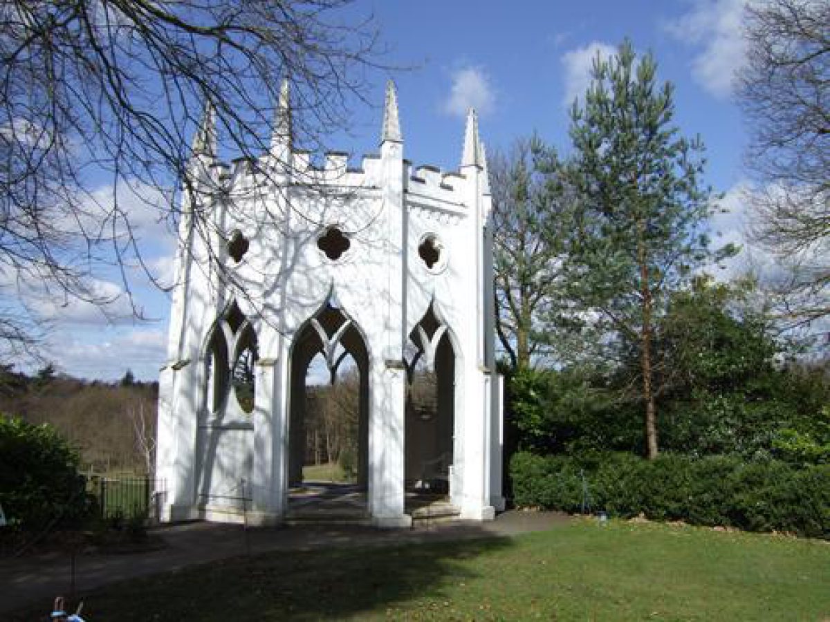
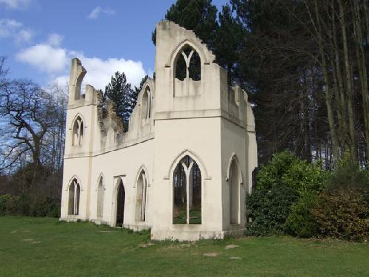
In the plantation at the top of the hill is a clearing known as the Amphitheatre, with a statue of the Rape of a Sabine Woman. The original of c 1750 was by van Nost after Giambologna. An avenue leads west to where the restored Gothic Temple (listed grade II*) frames views to the lake and the woods to the west. Paths lead down the hill to the Ruined Abbey (listed grade II), the site of Hamilton's brick and tile works, and the replanted vineyard. The Abbey was a later addition by Hamilton to the landscape (1772) and is not mentioned in earlier descriptions of the site. The vineyard was quite successful and Hamilton laid out a second north of the river.
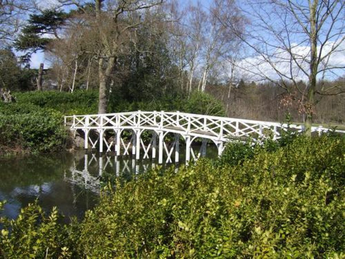
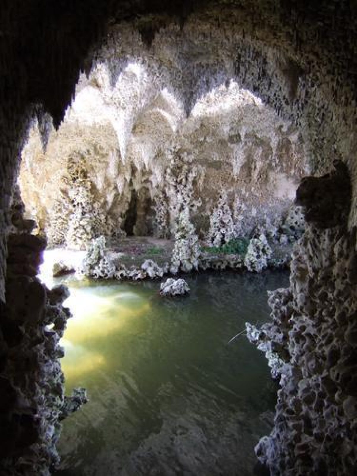
The path then leads over the wooden Chinese Bridge (restored, listed grade II) to an island in the lake with a large tufa arch. On the north of the island, c 450m south-west of the House, is the Grotto and an adjoining rockwork bridge (both listed grade II). The main chamber of the Grotto is currently (2003) undergoing restoration. It is a brick-built structure with timber beams and a slate roof, faced with oolitic limestone and rock. Inside it is decorated with fibrous gypsum, mauve fluorite, orange calcite, and other minerals; the main chamber had large stalactites and several cascades and pools. The Grotto was probably built by the Lanes, the most notable grotto-makers of the time who were also responsible for the grotto at nearby Oatlands (qv). A small Palladian bridge leads south-west back to the mainland.
The path then leads west to the Roman Mausoleum (listed grade II), which was contrived as a ruin standing in a loop in the river, before turning north towards the site of the Five-arch Bridge and then west to the Cascade situated c 780m south-west of the House at the west end of the lake. A brick duct runs c 200m south-west to the Water Wheel (listed grade II) which raises the water for the lake from the River Mole several metres below. The present iron wheel is 36 feet (c 11m) in diameter and was built by Bramahs in the 1830s to replace Hamilton's original wheel.
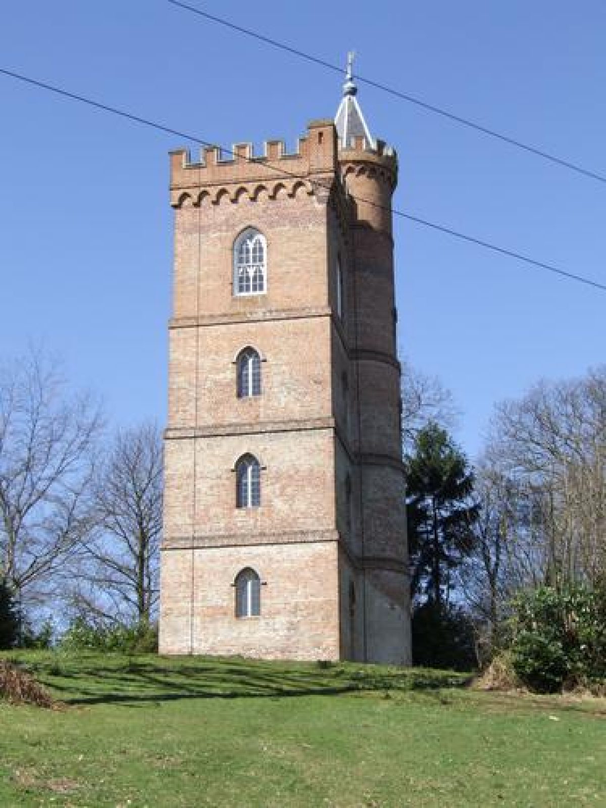
The western end of the site was known as the 'Alpine Wood', with steep slopes planted with a wide variety of trees. At the southern edge lay the Hermitage, a primitive wooden structure but with excellent views to the south over Surrey. At the furthest point of the site is the restored four-storey Gothic Tower (listed grade II*), c 1.3km west of the House; its setting is now spoilt by pylons and overhead power lines.
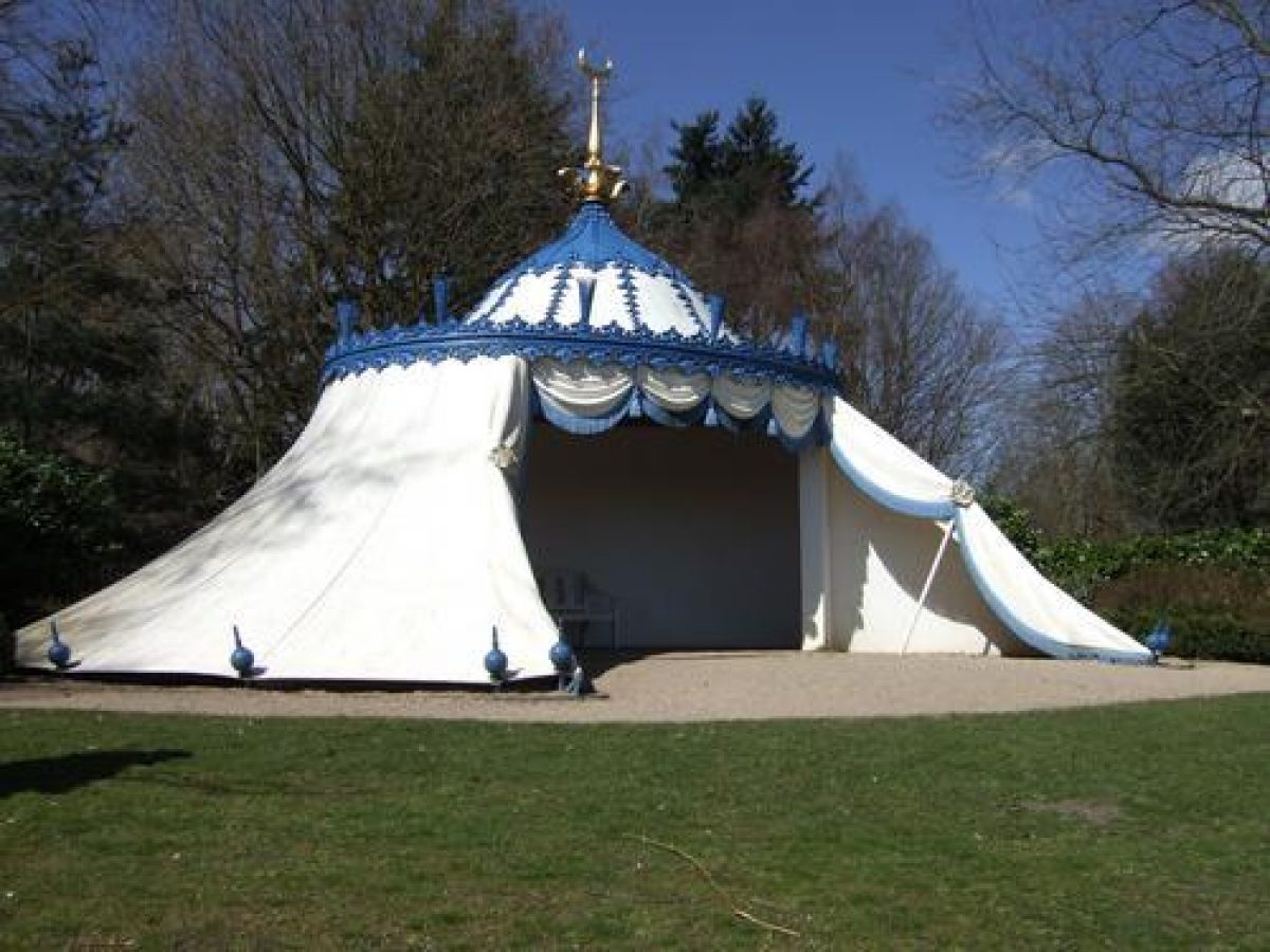
Turning east the tour visited the now-destroyed Temple of Bacchus, built to house a 7' (c 2m) statue of Bacchus which Hamilton had smuggled out of Italy, and then the ornate Turkish Tent. This final folly, now reconstructed some 50m from its original site (for current site restraint reasons), is situated on a knoll with fine views of the lake and across the so-called Elysian Field towards the House some 750m to the north-east, although this is now concealed by woodland outside the current park boundary. To the north, an area of c 11ha which was formerly within the park is now occupied by a farm and a Girl Guide Association campsite.
The path returns down the hill to the east, past the remains of the Roman Bath House, situated by a spring-fed pool near a group of cedars planted by Hamilton. This circular building of brick and plaster with a large thatched roof was added by Bond Hopkins in the 1780s and this building was extant until at least 1937 (Garden Hist 1999), although its tiled pool remains, together with the adjacent, restored water-raising horse pump. There is also a fine, recently restored ice house of c 1830 set in the hillside near the Gothic Temple.
Charles Hamilton was a respected gardener and a pioneer in planting new species. During a visit in 1781, Charles von Linnaeus declared that 'a greater variety of fir was to be found on this spot than in any other part of the world which he had ever seen' (Garden Hist 1983). Hamilton collected seeds from a variety of sources. He was in regular correspondence with Abbe Nolin in Paris, an adviser to Louis XV and Louis XVI (ibid) and imported seeds from North America through the Bartram and Collinson seed collecting supply route. Painshill was noted particularly for its cedars of Lebanon. Hamilton also planted a number of shrubberies, at a time when such things were unfashionable (ibid). Hamilton's successor, Benjamin Bond Hopkins continued his policy of planting newly introduced trees, and also developed several smaller scenes within the landscape, such as the Roman Bath House (Garden Hist 1999).
Kitchen Garden
The C18 walled kitchen garden (listed grade II) lies c 400m south-east of the House, adjoining the River Mole. It has an L-shaped plan and is divided into three compartments.
Maps
- John Rocque, Plan of Painshill, 1744 (MR 294), (PRO)
- OS 6" to 1 mile: 2nd edition published 1897' 3rd edition published 1920; 1934 edition
- OS 25" to 1 mile: 1st edition surveyed 1870; 2nd edition published 1896; 3rd edition published 1914
Description written: February 2000
Amended: May 2003, March 2023
Edited: October 2002
- Visitor Access, Directions & Contacts
Telephone
01932 868113Website
https://www.painshill.co.ukAccess contact details
The site is open daily throughout the year from 10.30 am.
Directions
The park can be reached from junction 10 of the M25. Follow the A245. There are also good public transport links by bus and train.
Owners
Painshill Park Trust Ltd
Portsmouth Road, KT11 1JE
- History
The following is from the Register of Parks and Gardens of Special Historic Interest. For the most up-to-date Register entry, please visit the The National Heritage List for England (NHLE):
www.historicengland.org.uk/listing/the-list
HISTORIC DEVELOPMENT
NOTE This entry is a summary. Because of the complexity of this site, the standard Register entry format would convey neither an adequate description nor a satisfactory account of the development of the landscape. The user is advised to consult the references given below for more detailed accounts. Many listed buildings exist within the site, not all of which have been here referred to. Descriptions of these are to be found in the List of Buildings of Special Architectural or Historic Interest produced by the Department of Culture, Media and Sport.
The site was part of Henry VIII's Honour of Hampton Court (see description of this site elsewhere in the Register) which was disparked in 1548 when Crown leases were granted to tenants and the Painshill area was divided into three farms. In 1738 Charles Hamilton acquired the farms from William Bellamy, a successful barrister. The previous encumbent was the Marquis du Quesne, who had lost a fortune in the collapse of the South Sea Bubble and it was probably he who built the house near Portsmouth Road which was occupied by Hamilton.
Hamilton was born in Dublin in 1704, the ninth son and youngest of 14 children of James, the 6th Earl of Abercorn. After studying at Oxford, where he became a lifelong friend of Henry Fox, Hamilton visited Europe on at least two occasions for the Grand Tour. In 1738 he began to acquire land in Cobham, where he took over the Crown leases of the three farms as well as purchasing additional land giving a total of around 80 hectares. Hamilton proceeded to create what Horace Walpole called 'a fine place out of a most cursed hill' (Walton and Weybridge Local Hist Soc 1986).
The garden contained a series of 'living pictures' (WWLHS 1986), designed to provoke moods and sensations, with sudden changes of scenery interspersed with architectural features and variations in colour by the careful mixing and placing of foliage. Hamilton was always short of money, which led to a series of business ventures which included a vineyard and a brick and tile works at Painshill. His knowledge of plants was respected by his contemporaries and he supplied seeds to nurseries. By 1773 he was forced to sell Painshill as he was being pressed by Henry Fox and Henry Hoare (of Hoares Bank) for the repayment of loans and he retired to Bath where he died in 1786.
The site was acquired by Benjamin Bond Hopkins, who built a new mansion completed in 1778. Even when the house was complete, Hopkins spent little time at Painshill as in 1777 he had acquired Wimbledon House, where he laid out a park with a lake, grotto, and cascade. He did however continue Hamilton's work of planting new species and also developed new features in the landscape.
After Hopkins' death, Painshill had a number of owners, including William Cooper, High Sheriff of Surrey, who employed Decimus Burton to make alterations to Painshill House. He employed the firm of Bramah to build a suspension bridge over Portsmouth Road and to replace with a more modern version Hamilton's water wheel which raised water from the River Mole to the lake at Painshill.
The owners until the Second World War were the Combes, responsible for rockeries on the site of Hamilton's vineyard and the removal of the columns from the Temple of Bacchus to grace the portico of Painshill Park House. The site was requisitioned for the Canadian Army during the war, and afterwards purchased by the Baroness de Veauce, who converted the House and outbuildings into private dwellings which were sold off. The park was also split into lots and sold for various uses, including forestry and agriculture.
In 1975 a group of Cobham residents formed the Friends of Painshill, and together with the Garden History Society and the Georgian Group brought pressure to bear on the local authority (Elmbridge Borough Council) to purchase the site. By 1980, some 62 hectares of the pleasure grounds had been acquired, and the Painshill Park Trust set up with the object of restoring the 18th-century landscape to its former glory. The Trust has researched and restored the park and its buildings to the highest standards and now (2003) has the Hermitage, the Temple of Bacchus, the Five-arch Bridge, the Palladian south bank bridge, and the later Bath House and Boat House still to be rebuilt. The area of the park owned by the Trust is open to the public while the house and remaining parkland are in divided private ownership.
- Associated People
- Features & Designations
Designations
The National Heritage List for England: Register of Parks and Gardens
- Reference: GD1021
- Grade: I
Features
- River
- Description: River Mole.
- Lake
- Mansion House (featured building)
- Earliest Date:
- Latest Date:
- Key Information
Type
Park
Purpose
Ornamental
Principal Building
Domestic / Residential
Survival
Extant
Hectares
86
Open to the public
Yes
Electoral Ward
Cobham and Downside
- References
References
- {English Heritage Register of Parks and Gardens of Special Historic Interest}, (Swindon: English Heritage, 2008) [on CD-ROM] Historic England Register of Parks and Gardens of Special Historic Interest
- Jones, Barbara {Follies & Grottoes} (London: Constable & Co., 1953) 39-44 Follies & Grottoes
- Symes, M. {Fairest Scenes: Five Great Surrey Gardens} ([Elmbridge]: Elmbridge Museum Service, 1988), pp. 36-49 Fairest Scenes: Five Great Surrey Gardens
- Eyres, P {Painshill Park : the pioneering restoration of an 18th-century landscape garden : the proceedings of the Painshill Park & Beyond Conference, Painshill Park, 24-25 June 2010} ( New Arcadian Press, 2010) Painshill Park : the pioneering restoration of an 18th-century landscape garden : the proceedings of the Painshill Park & Beyond Conference, Painshill Park, 24-25 June 2010
- Land Use Consultants {Walled Garden, Painshill, Conservation Management Plan} (1999) Walled Garden, Painshill, Conservation Management Plan
- Vol 1, (6 March 1897), p 239; 15 (19 March 1904), p 414; 166 (13 December 1979), p 2332; 169 (12 March 1981), p 638; 195 (4 January 2001), pp 28-35 Country Life
- no 1 (1973), p 39; 8, no 1 (1980), p 91; 11, no 2 (1983), p 112; 27, no 2 (1999), pp 238-43 Garden History
- Walton and Weybridge Local History Society Monograph 23, (1986) Painshill
- Related Documents
-
CLS 1/156/1
Painshill Park Master Plan - Hard copy
Land Use Consultants - 1984
-
CLS 1/156/2
Survey of the landscape of Painshill Park - Hard copy
not stated: Debois Landscape Survey Group? - undated 1982?
-
CLS 1/156/19
Comments on the Appendices for CLS 1/156/2 - Hard copy
T.O'Brien, Peter Goodchild, - undated
-
CLS 1/156/20
History of Ownership to 1738 - Hard copy
undated
-
CLS 1/156/21
Place Names - Hard copy
-
CLS 1/156/22
Ecological Surveys - Hard copy
-
CLS 1/156/23
Development and Function of the Lake Islands - Hard copy
-
CLS 1/156/24
The Bridges - Hard copy
-
CLS 1/156/25
Annotations to Field Archaeology Maps - Hard copy
-
CLS 1/156/26
Plant Species List - Hard copy
-
CLS 1/156/27
Waterwheel and Works, (Inc. the Boathouse - Hard copy
-
CLS 1/156/28
Observation and Notes on main Tree Species at Painshill - Hard copy
-
CLS 1/156/29
Transcript of Historical Accounts - Hard copy
-
CLS 1/156/1