Introduction
Nuneham Courtenay has a garden situated within about 470 hectares of landscape park, laid out in 1756 and re-designed between 1779 and 1782 by Lancelot Brown. The gardens and pleasure grounds directly associated with the house occupy about 22 hectares. Various developments had taken place before the gardens were restored in the late-20th century.
Terrain
The park overlies low, undulating hills, with a steep slope towards the west boundary where the land drops down to the river.www.historicengland.org.uk/listing/the-list
A country house surrounded by an C18 landscape park and pleasure grounds laid out in three phases: 1760s, the first Earl Harcourt's classical landscape to offset his Greek 'temple' (church); William Mason's picturesque landscape of 1777 for the second Earl (Mason having laid out a famous flower garden here in 1771); the parkland laid out by Lancelot Brown 1779-82 (supervised by the second Earl and Mason), when he also laid out Brown's Walk in the pleasure grounds. A pinetum and other work was carried out by W S Gilpin, 1832.
DESCRIPTION
LOCATION, AREA, BOUNDARIES, LANDFORM, SETTING
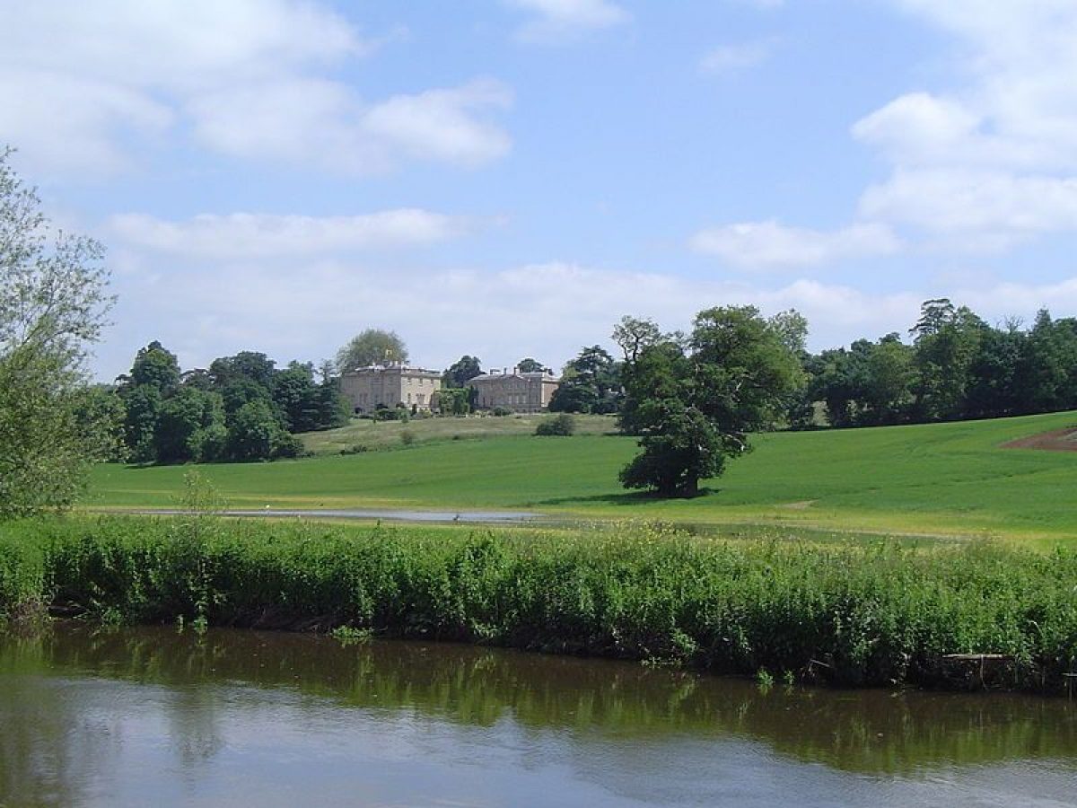
Nuneham Park lies 6km south of Oxford, adjacent to the west side of the village of Nuneham Courtenay. The 470ha estate is bounded to the west by the River Thames, and on the other sides largely by agricultural land and woodland. The largely rural setting also includes Culham scientific laboratories to the south. The park overlies low, undulating hills, with a steep slope towards the west boundary where the land drops down to the river. Important long views look west towards Abingdon and north towards Oxford.
ENTRANCES AND APPROACHES
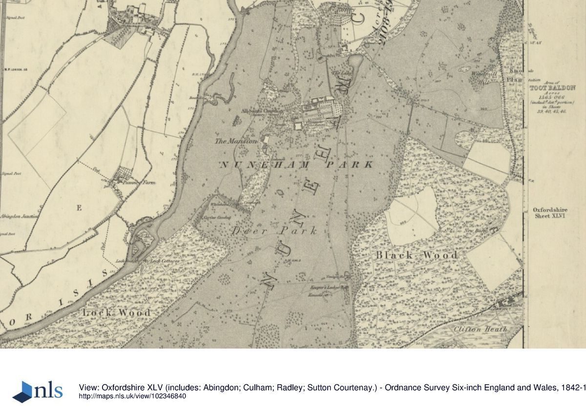
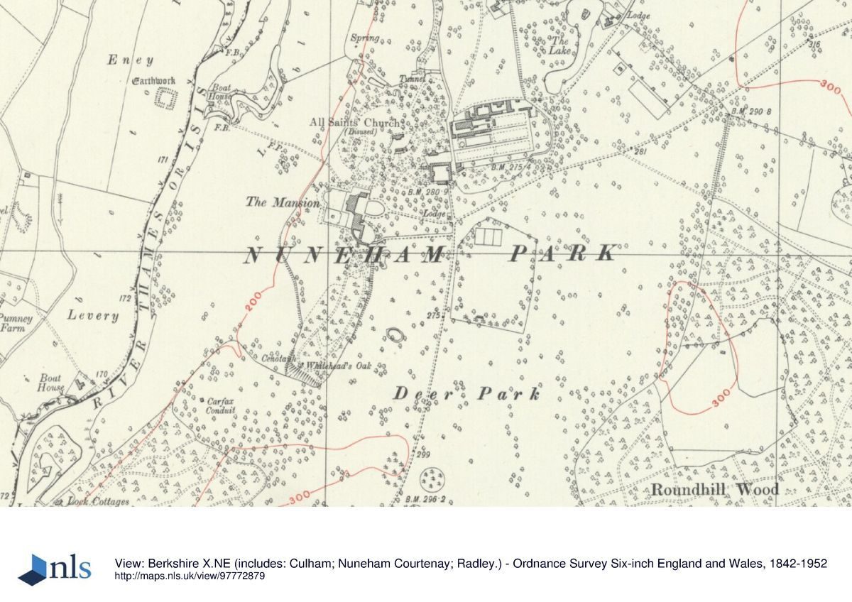
The main drive now (1998) enters the park via an approach road running south, off the A423 Oxford to Henley road (the old turnpike road), from the centre of the village of Nuneham Courtenay. The drive enters the park 900m north-east of the House, passing a small, single-storey lodge with a projecting entrance bay, lying adjacent to the drive. The drive continues south-west past The Lake to the west (the old village pond, enlarged in the late C18), 600m north-east of the House. A spur west from the drive, at the south end of The Lake, gives access to Home Farm and the walled garden. The main course skirts to the east and south of the walled garden, running in a straight line along the remains of a broad lime avenue to reach the early C20 Manor Lodge, 200m east of the House, standing at the entrance to the enclosed east lawn. Passing to the south of the Lodge, and between contemporary iron gate piers, gates and flanking railings, the drive extends west down a shallow grass slope, bounded to the south by iron railings and a clipped beech hedge, before dividing into two to enter the forecourt at the north-east and south-east corners. The forecourt, flanked by the north and south wings of the House, is bounded to the east by a low stone wall with low square piers (early C19, listed grade II) marking the drive entrances. The Manor Lodge was built and the course of the drive within the enclosure altered by Lewis Harcourt, 1904.
A further drive, from the 1830s the main ornamental drive (now largely disused and lost in places), enters the park 1.5km north-east of the House, off the Oxford to Henley road, giving access at its north end to the Arboretum. Set back off the road, the entrance is flanked by two pairs of stone piers with iron carriage and pedestrian gates, from which curve stone screen walls terminated by a further pair of piers. A single-storey stone lodge lies to the south of the entrance, built in Classical style, with a prominent entrance portico facing the drive. The drive runs south-west through the Arboretum, crossing the park to join the north drive at the east end of the lime avenue, 450m east of the House. This drive was constructed by Archbishop Harcourt in the 1830s, having acquired land outside the park to the east, at the same time employing W S Gilpin to lay out at its east end the surrounding pinetum, now the Arboretum. Before this, the main drive during the C18 and early C19 entered at a point between this entrance and the present main entrance, at the south end of the village street. Remains of this former drive exist south of the present drive, which it joins.
The south drive, now disused but before c 1900 the principal entrance from London, enters the park 2km south-east of the House, past the site of the Abingdon Lodge (now gone). The drive curves north-east through the park, with views to the west, south and east opening up at various points, joining the main drive by Manor Lodge, 200m east of the House. At the north-west corner of the park, the ferry (now gone) gave direct access from the Abingdon and the west bank of the river, past Ferry Cottage, a single-storey, rendered building. The drive from here runs east and south, ascending the steep slope from the river into the park, passing the stables and walled garden, joining the main drive 200m east of the House by Manor Lodge.
PRINCIPAL BUILDING
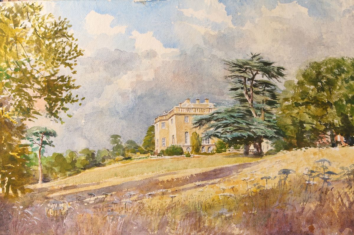
Nuneham House (1757, listed grade II*) lies towards the north-west corner of the park. It was built by Stiff Leadbetter for the first Earl Harcourt, altered in 1781 by Lancelot Brown and Henry Holland for the second Earl, and extended in 1832 by Sir Robert Smirke for Archbishop Harcourt. The main block of the three-storey, limestone house, is flanked by quadrant links and connected pavilions, which together surround three sides of the entrance courtyard to the east, overlooking the east lawn. The west, garden front overlooks an open, informal lawn with clumps of trees, with views west over the river towards Abingdon. The north front overlooks the northern pleasure grounds and the church, with views towards Oxford.
The remains of the stable buildings lie 200m north-east of the House, at the north-east corner of the east lawn. The main, severely classical, ornamental block (probably James Stuart 1760s) which formed the south side of the square courtyard has gone (mid C20), together with much of the west side. Two sides of an open yard of two-storey C18 buildings remain, the central area now grassed.
GARDENS AND PLEASURE GROUNDS
The gardens and pleasure grounds surround the House, with the main informal features, largely laid out in the later C18, to the north and south, and C19 and early C20 terraces lying adjacent to the House. The pleasure grounds to the east and north overlie part of the site of the village before it was largely demolished in 1761 and was moved to its present site (Oxoniensia 1968; Beresford 1971). This is the site which inspired Oliver Goldsmith's poem The Deserted Village (1770).
Brown's Walk, laid out by Lancelot Brown in 1779, lies south of the House on the west-facing slope above the river. It is a curving, looped woodland walk from the House, partly overlying a former walk to a Corinthian seat of the early 1760s (now gone). The southernmost end of the walk overlooks a small, steep valley, and on the opposite hillside (Brown's Hill), in open pasture, stands the Carfax Conduit (John Clarke 1617, late C18, listed grade I). The square, wallstone plinth (late C18) is decorated with C17 stone ornamentation, originally part of the Carfax conduit in central Oxford. When the conduit was dismantled, the cistern remained in Oxford, the stone ornamentation being removed to the park in 1789 by the second Earl, who used the structure in place of the ruined tower recommended by Lancelot Brown in his 1779 scheme. The north end of Brown's Walk is reached from the House via the southern end of the balustraded and gravelled terraces (W S Gilpin 1830s), with formal flower borders (c 1900-10) surrounding the House to the north, west and south. A path leads from the terrace on the north front towards All Saints' church and Mason's Garden within the northern pleasure grounds. Brown's Walk, the formal terraces, and the northern pleasure grounds are bounded to the west by an informal open lawn above fields leading down to the river, with a ha-ha in places separating the lawn from the field below. The lawn is reached from the terrace on the west front by a set of stone steps.
All Saints' church (first Earl Harcourt, assisted by James Stuart, 1764, listed grade II*), sited on a promontory 200m north-east of the House, overlooks the river to the west and north, and beyond this enjoys views towards Oxford and its surrounding hills to the north, and Abingdon to the west. Lawns slope steeply away to the west and north, to the edge of the pleasure grounds, and a straight terraced path, sited at the top of the north slope, runs along the north front of the church and beyond to the east for c 100m. One of the first churches built as a garden ornament, it was intended as a temple in the classical landscape formed by the first Earl, its north front echoing the entrance front of Chiswick House (qv), and reached, when first built, by a straight avenue walk north from the House. The dome was used as a rotunda, appearing to surmount the orangery (of which only the back wall remains) in Mason's Garden, below to the south.
Mason's Garden, an informal grouping of flower borders within lawn, is surrounded by trees and shrubs, with various small structures and buildings occurring as incidents along the perimeter circuit walk. Some of the original built features have gone, but the Temple of Flora (c 1771, listed grade II) remains a dominant feature, lying on the east boundary of the garden, 160m north-east of the House. The Temple is a small, rectangular, rendered building in Greek-Doric style with an open portico on the west side, overlooking the main east/west vista in the Garden. The grotto and rockery (c 1771 and later, listed grade II) lie on the south boundary, the exterior resembling a rocky cliff, with a central entrance leading to the grotto. The remains of the orangery lie on the north boundary, consisting largely of the rear brick wall, the stone-paved floor being retained as a terrace with low balustrading on the south side.
The Garden, laid out by William Mason c 1771-2, modified in the 1830s by W S Gilpin, and partially restored in the late C20, is important for its early introduction of informality. For a fuller account of its structure (together with the surrounding pleasure grounds), symbolism and influence, the reader is referred to Batey 1968 (CL) and 1979 (guidebook). Several listed structures exist within this area, not all of which have been referred to here; descriptions of them are to be found in the List of Buildings of Special Architectural or Historic Interest produced by the Department of Culture, Media and Sport.
PARK
The park surrounds the House, consisting of pasture and arable land, and woodland which is largely sited on the boundaries. The steep slope to the west leads down to the river, with extensive views to the west and north. The central area gives views south and south-east towards the Sinodun Hills north-west of Wallingford, and the surrounding countryside. The brick icehouse lies at the northern boundary, in woodland 750m north of the House. Lacking doors and with its brick dome exposed, it has lost any earth cover it may once have had. A cattle tunnel in the north park leads from Brown's oxpens through the ha-ha beneath Mason's picturesque terrace, avoiding the pleasure ground.
Lancelot Brown (1716-83) worked on the park from 1779 to 1782, it being modified by Lord Harcourt in 1795 when he needed to grow more grain when the country was threatened by famine in the French Revolutionary Wars.
The Rectory (1759, listed grade II) also stands on the northern boundary, together with its contemporary walled garden (1761, listed grade II), 20m to the east. The symmetrical, two-storey, yellow stone house was re-sited by the first Earl from the old village site to high ground facing the river, when he moved the village. The rectangular walled garden is surrounded by brick walls, those to the south and west being of crinkle-crankle form, and those to the north being straight and possibly of later date.
The Harcourt Arboretum was laid out as a pinetum in the 1830s by W S Gilpin, in order to grow the North American conifers being introduced at that time. He used similar promontory-type planting of shrubs in the ridings to that which he had used in Mason's Garden. The Arboretum is now managed as a satellite garden of Oxford University Botanic Garden, with mature trees and informal shrub beds within grassed woodland rides.
KITCHEN GARDEN
The 2ha kitchen garden stands 250m north-east of the House, surrounded by red-brick walls, and is now (1997) largely derelict. It is divided into three narrow, rectangular sections by further brick walls with, at the west end, the gardener's house, and, at the main entrance in the east wall, an ornamental gateway (listed grade II). The entrance is flanked by C18 iron gates with an elaborate scrolled overthrow, and brick piers probably rebuilt in the late C19 or early C20. A hooped iron pergola runs along the central section of the walled garden, leading to the gateway. Home Farm and its farmhouse stand adjacent to the north wall. The southern section of the garden is now largely occupied by late C20 repository buildings belonging to the Bodleian Library.
The kitchen garden remains largely as seen on Lancelot Brown's plan of 1779, where it is referred to as the Melon Ground, and was possibly laid out by him (M Batey pers comm, 1999).
REFERENCES
Country Life, 34 (29 November 1913), pp 740-55; 90 (7 November 1941), pp 866-70; (14 November 1941), pp 910-13; 144-5 September 1968), pp 541-2; (12 September 1968), pp 640-2
Victoria History of the County of Oxfordshire 5, (1957), pp 234-42
Oxoniensia XXXIII, (1968), pp 108-24
M Beresford, Deserted Medieval Villages (1971), pp 54-6
N Pevsner and J Sherwood, The Buildings of England: Oxfordshire (1974), pp 726-9
D Stroud, Capability Brown (1975), pp 189, 235, pls 60A & B
M Binney and A Hills, Elysian Gardens, (SAVE 1979), p 18
Nuneham, guidebook, (M Batey, 2nd edn 1979)
F Woodward, Oxfordshire Parks (1982), pp 24, 26
M Batey, Oxford Gardens (1982), pp 118-21, 136-67
RCHM(E), Yesterday's Gardens, (1983), ill 68
D Jacques, Georgian Gardens (1983), pp 94-5
Maps
R Davis, A New Map of the County of Oxford ..., 1797
A Bryant, Map of the County of Oxford ..., surveyed 1823
OS 6" to 1 mile:
1st edition published 1881-2
2nd edition published 1901
3rd edition published 1938
OS 25" to 1 mile: 1st edition published 1875
Description written: November 1997 Amended: March 1999
Register Inspector: SR
Edited: March 2000
- Visitor Access, Directions & Contacts
Directions
5 miles south-east of Oxford
- History
The following is from the Register of Parks and Gardens of Special Historic Interest. For the most up-to-date Register entry, please visit the The National Heritage List for England (NHLE):
www.historicengland.org.uk/listing/the-list
HISTORIC DEVELOPMENT
The Harcourts, during the Middle Ages, lived at Stanton Harcourt, 10km west of Oxford. Sir Simon (later Viscount) Harcourt bought the manor of Newnham in 1712, although the Harcourt seat was not moved to Newnham Courtenay until 1760. By this time Sir Simon's grandson, the first Earl Harcourt (1714-77), had constructed a new house, designed by Stiff Leadbetter; at this point the spelling of the name was altered to Nuneham. The House was deliberately sited on a wooded knoll above the River Thames to take advantage of the views down to the water, of Oxford's dreaming spires, and into the broad countryside beyond. At the same time surrounding landscaped grounds were laid out. In the early 1760s the first Earl transplanted the village of Newnham, now within his landscape park, to the Oxford to Henley turnpike, building an entirely new settlement for his tenants, demolishing the old village and incorporating the site into the park and pleasure grounds. He replaced the old parish church with a new one, designed to act as classical temple within his new pleasure grounds. The first Earl's son, Lord Nuneham (later second Earl) prevailed upon his friend, the poet William Mason c 1771-2 to design the informal Flower Garden which became influential on fashions in flower gardening, and was acclaimed as a revolution in taste and sentiment (Batey 1979).
In 1777 the second Earl (1736-1809), a friend and patron of Rousseau, inherited Nuneham. He called upon William Mason to lay out a picturesque landscape upon the first Earl's classical landscape north of the House. The Earl was patron of William Sawrey Gilpin (1762-1843), and wrote his own guidebook, showing that his landscaped garden was to be seen and appreciated like a Gilpin picturesque tour with defined 'stations' for viewing the Thames Valley landscape (Batey and Lambert 1990). The Earl employed Lancelot Brown from 1779 to 1782 and, together with Mason, advised Brown on the transformation of the first Earl's scene into an idealised landscape 'with hanging woods, lush meadows and Abingdon church spire set against the Berkshire hills' (Batey 1979), expanding the park significantly. W S Gilpin, employed in the 1830s, laid out a picturesque pinetum on newly acquired land by the Oxford road, at the same time modifying Mason's Flower Garden. The RAF occupied the estate during the Second World War, after which Lord Harcourt sold the estate to the University of Oxford. The House is now (1997) a religious centre, leased from the University.
Period
- 18th Century (1701 to 1800)
- Late 18th Century (1767 to 1800)
- Associated People
- Features & Designations
Designations
The National Heritage List for England: Register of Parks and Gardens
- Reference: GD1017
- Grade: I
Style
English Landscape Garden
Features
- Lawn
- Herbaceous Border
- Specimen Tree
- Temple
- Garden Terrace
- Grotto
- Rockery
- Sculpture
- Villa (featured building)
- Description: Palladian villa.
- Earliest Date:
- Latest Date:
- River
- Description: River Thames.
- Lake
- Description: which was a pond (enlarged late C18)
- Key Information
Type
Park
Purpose
Ornamental
Principal Building
Domestic / Residential
Period
18th Century (1701 to 1800)
Survival
Extant
Hectares
470
Open to the public
Yes
Civil Parish
Nuneham Courtenay
- References
References
- {English Heritage Register of Parks and Gardens of Special Historic Interest}, (Swindon: English Heritage, 2008) [on CD-ROM] Historic England Register of Parks and Gardens of Special Historic Interest
- Stroud, D., {Capability Brown} (London: Faber, 1975), pp. 189, 235, plates 60A & B Capability Brown
- Batey, M. and D. Lambert, {The English Garden Tour: a view into the past} (London: Murray, 1990) The English Garden Tour: a view into the past
- Pevsner, N. and J. Sherwood, {The Buildings of England: Oxfordshire} (Harmondsworth: Penguin, 1974), pp. 726-9 The Buildings of England: Oxfordshire
- Batey, M., {Oxford Gardens} (Amersham: Avebury, 1982), pp. 118-21, 136-67 Oxford Gardens: The University's Influence on Garden History
- Nicholas Pearson Associates; Debois Landscape Survey Group {Nuneham Courtenay Conservation Management Plan} (2009) Nuneham Courtenay Conservation Management Plan
- Related Documents