Introduction
The Oxford Botanic Garden is an early-17th-century formal garden with plant collections. It originally occupied about one hectare, and there is additional land outside the original walled garden. The site includes glasshouses, a fernery, water and bog gardens and a variety of borders, many arranged according to botanical classification.
Terrain
The level site occupies former flood meadows in the Cherwell Valley.www.historicengland.org.uk/listing/the-list
Early 17th-century walled university physic garden, the oldest of its kind in Britain.
DESCRIPTION
LOCATION, AREA, BOUNDARIES, LANDFORM, SETTING
Oxford Botanic Garden lies close to the centre of Oxford at the east end of the High Street, next to Magdalen Bridge, the level site occupying former flood meadows in the Cherwell Valley. The 2ha garden is bounded to the east and south by the River Cherwell and beyond this Magdalen College School playing fields, to the south-west by Merton Field and Christ Church Meadow; to the north by the Penicillin Memorial Rose Garden (designed by Dame Sylvia Crowe mid C20, for Magdalen College) and The High and to the west by Rose Lane and adjacent college buildings.
ENTRANCES AND APPROACHES
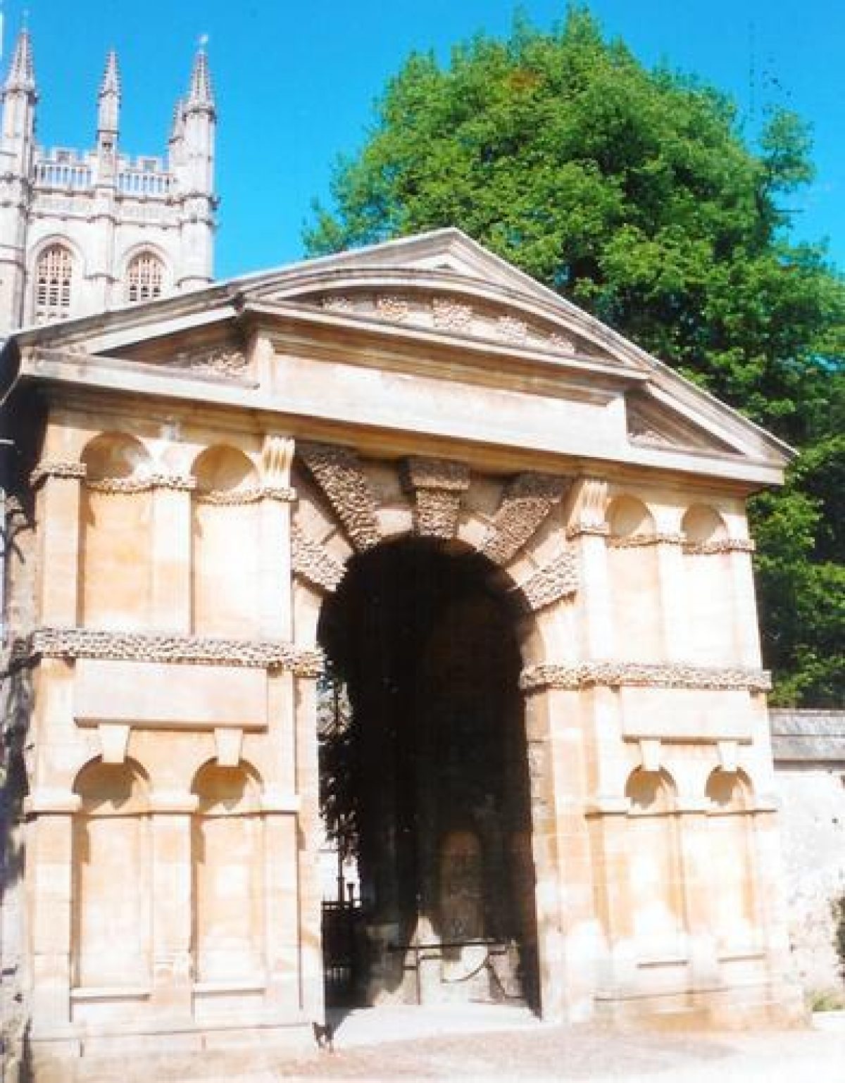
The main entrance, at the centre of the north garden wall, lies set back from, and slightly lower than, the High Street, opposite Magdalen College tower. Iron gates (and formerly wooden doors) are set within the Danby Arch (Nicholas Stone 1632, listed grade I), an imposing, two-storey, Mannerist archway in Headington Freestone, flanked by stone walls, with a small doorway with similar motifs close by in the wall to the east. Two lesser gateways (Nicholas Stone 1632-3, listed grade I), in similar style to, but on a smaller scale than, the Danby Arch, give access to the walled garden, that to the west off Rose Lane via wooden doors, and that from the river to the east via iron gates, each set within contemporary garden walls.
GARDENS
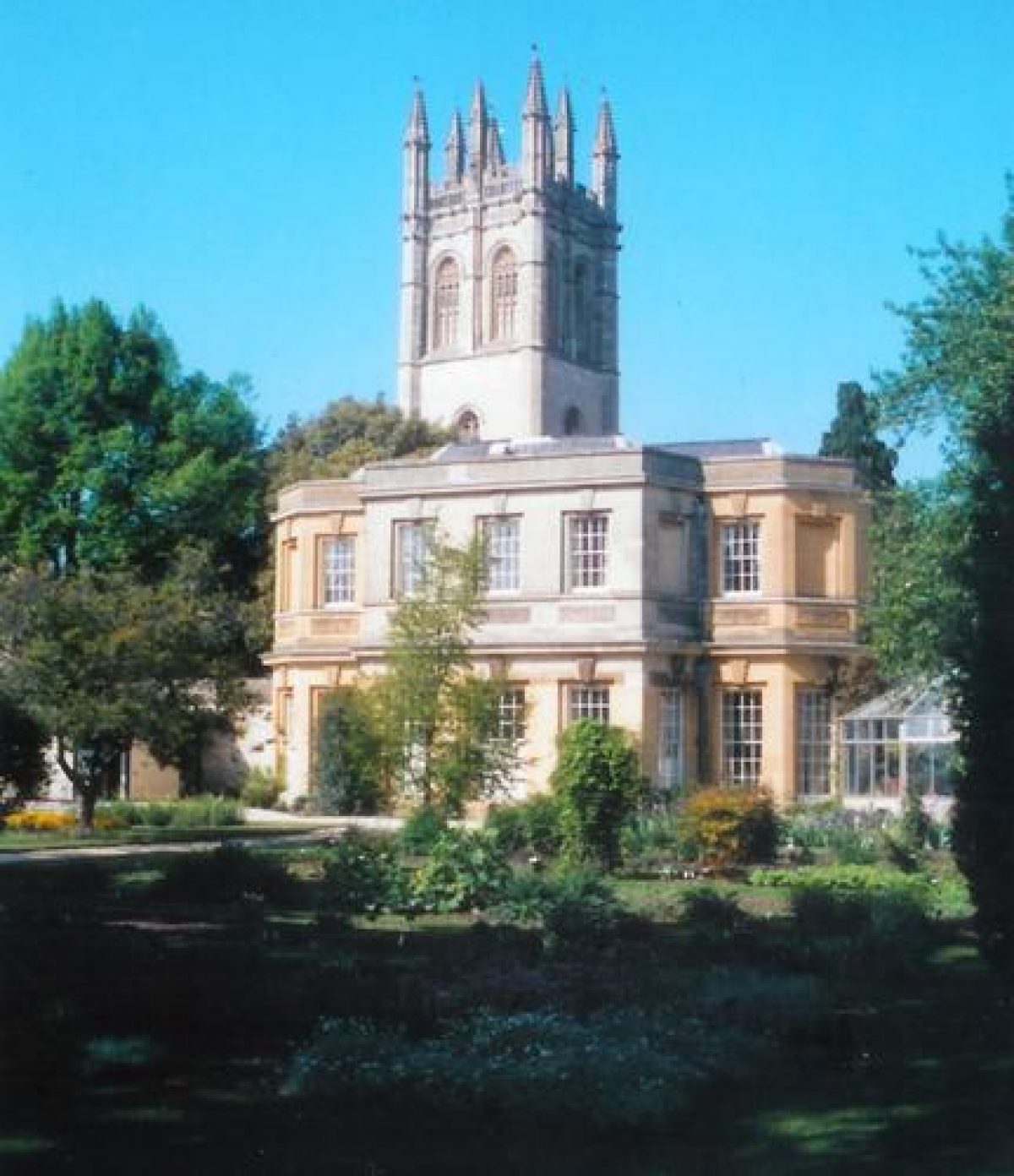
The garden is dominated by 100m long, 5m high, ashlar walls (Nicholas Stone 1623 and later, listed grade I) with stone coping, enclosing the original, square Physic Garden. Short stretches of wall have been removed to create access in the north-east corner, and in the centre of the south wall, where the resultant opening is flanked by square pillars with vase finials. The Oxford Almanac (1766) shows the first successful glasshouses built in the garden, lean-to structures which lasted until the mid C19, sited against the north wall flanking the Danby Arch. The north wall now (1997) has a C20 aluminium structure at its east end, adjacent to the original library and herbarium building (c 1735, 1835, listed grade I), now Magdalen College Bursary. This building consists of two sections to north and south: the south elevation, originally of one storey, was formed around the easternmost orangery, built by William Townesend 1733-5 and modified in 1835 by H J Underwood, who raised the building to two storeys and constructed the north elevation in similar style. At the west end of the wall is the West Block (listed grade II), its south facade in similar style to the Bursary, retaining at its centre the westernmost of Townesend's two orangeries.
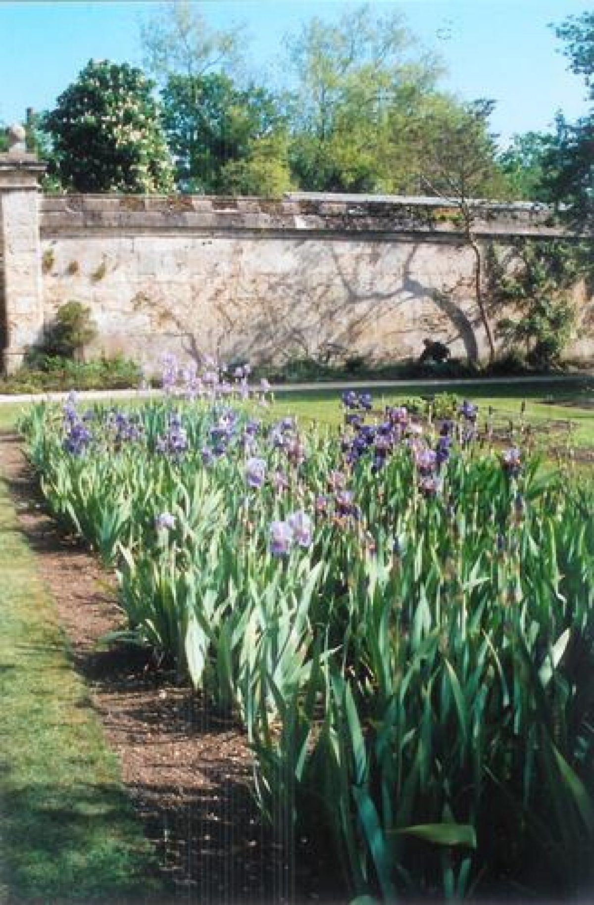
The walled garden is divided by gravel paths into eight rectangular quarters largely containing narrow, rectangular beds within lawns, with two cruciform paths aligned on the central gateways, the whole surrounded by a perimeter path and overlooked by the late C15 Magdalen College tower. At the centre lies a circular pond (C19, listed grade II), with a stone basin surmounted by a central basin and jet. Throughout the garden is planted a collection of mature trees including, close to the south wall, one of Bobart's original yews.
Almost the whole of the outer side of the east wall, facing the lawn which runs down to the river, is occupied by a range of glasshouses, on the outline of predecessors erected by the then Professor of Botany, Charles Daubeny, in 1851 and rebuilt in 1893, 1949 and 1972. These buildings include a palm house, tropical water lily house, succulent house, service ranges and potting sheds. From this part of the garden there are views across the river to Magdalen Bridge and playing fields.
Outside the west wall a service area lies south of the gateway, while to the north are lawns with mature trees, the remains of a C19 pinetum planted by the Keeper William Baxter, who advised on the planting of local gardens, notably Park Town (qv) in North Oxford. South of the walled garden lies the area largely incorporated into the gardens c 1945. This area, bisected by an extension of the central north/south path aligned on the Danby Arch, is arranged informally, and includes an herbaceous border, bog garden (rebuilt 1997), shrub beds and a rock garden (built 1926, rebuilt 1946, 1965, 1998) flanking a circular lily pond lying adjacent to the south entrance of the walled garden. The Cottage (1623, C18, listed grade II), attached to the west end of the south wall, has continued as the Superintendent's house since its initial erection. The rear portion, against the wall, is probably C17, the front being C18, of ashlar with two storeys and two unequal gables.
Loggan's bird's-eye view (1675) seems to be the earliest depiction of the gardens, Hollar's map of 1643 showing meadows on the site. It shows the layout of narrow beds in geometrical patterns in each quarter, surrounded by low fences or walls, at the centre a small, circular pond or well, the whole surrounded by stone walls and the gateways which are illustrated alongside. A short path, flanked by shrubs clipped into topiary shapes, leads to the Danby Arch from the north (no flanking doorways shown), to the east the outline of a path runs from the gateway to the river side, and to the south is what appears to be an extension of the river running parallel with the south wall, bounding a walk below the wall, reached from a small, central doorway, with a semicircular garden feature beyond. No features appear outside the west wall. A conservatory for evergreens, as Loggan illustrated on his view, now gone, may have been sited on a wall beyond the north wall adjacent to the High Street, shown in outline on Loggan's map of Oxford (1675).
In 1850, under the direction of Charles Daubeny, Professor of Botany, the shape of the beds was altered from narrow rectangles to irregular, informal shapes (OS 1878). Isaac Balfour, a later Botany Professor, directed further rearrangement, 1884-8, creating long, rectangular beds arranged to display the plants according to the taxonomic system created by Bentham and Hooker, which is the basis for the surviving layout (1997).
REFERENCES
University of Oxford Botanic Garden, guidebook, (1971, 1989, 1995)
N Pevsner and J Sherwood, The Buildings of England: Oxfordshire (1974), pp 267-8
Country Life, no 51 (19/26 December 1996), pp 48-51
Maps
Agas/Bereblock, Map of Oxford, engraved 1728 from 1578 original
Hollar, Map of Oxford, 1643
Loggan, Map of Oxford, 1675
R Davis, A New Map of the County of Oxford ..., 1797
A Bryant, Map of the County of Oxford ..., surveyed 1823
OS 6" to 1 mile: 1st edition published 1881-2; 2nd edition published 1901; 3rd edition published 1926
OS 25" to 1 mile: 1st edition published 1880
OS 1:500: 1st edition published 1878
Description written: October 1997
Amended: March 1999
Edited: March 2000
- Visitor Access, Directions & Contacts
Telephone
01865 610300Access contact details
The site is open daily, except Christmas and Boxing days. Please see: http://www.botanic-garden.ox.ac.uk/opening-times
Directions
Off Oxford High Street, opposite Magdalen College.
Owners
University of Oxford
- History
The following is from the Register of Parks and Gardens of Special Historic Interest. For the most up-to-date Register entry, please visit the The National Heritage List for England (NHLE):
www.historicengland.org.uk/listing/the-list
HISTORIC DEVELOPMENT
Henry Danvers, first Earl of Danby, gave £5000 in 1621 for a Physic Garden which was sited in the north-east corner of Christ Church Meadow, on land belonging to Magdalen College, part of which had been the Jewish burial ground until 1293. The land, outside the city walls, was raised to counteract flooding by the addition of 4000 loads of 'mucke and dunge' (guidebook 1995). After this, during the 1620s, the walls were erected, the archways being built during the early 1630s by Nicholas Stone, Inigo Jones' master mason. The first of fifteen Superintendents, Jacob Bobart, who was appointed in 1642, published a catalogue of 1300 trees and plants growing in the garden in 1648. Bobart, upon his death in 1679, was replaced by his son, Jacob the Younger, who also became Professor of Botany. There followed a succession of Superintendents and Professors, and the fortunes of the garden waxed and waned, it being renamed the Botanic Garden by Professor Daubeny in 1840. In 1945 the area beyond the south wall was incorporated from Christ Church Meadow. The Garden remains (1997) part of the University, and an educational facility.
- Associated People
- Features & Designations
Designations
The National Heritage List for England: Register of Parks and Gardens
- Reference: GD1433
- Grade: I
Plant Environment
- Environment
- Walled Garden
Features
- Glasshouse
- Ornamental Fountain
- Ornamental Pond
- Pool
- Description: Circular
- Herbaceous Border
- Botanical Bed
- Lawn
- Shrubbery
- Specimen Tree
- Vase
- River
- Description: River Cherwell.
- Water Garden
- Bog garden
- Water Lily House
- Pond
- Description: Circular lilly pond
- Key Information
Type
Collection
Purpose
Educational
Plant Environment
Environment
Principal Building
Education
Survival
Extant
Hectares
2
Open to the public
Yes
- References
References
- {English Heritage Register of Parks and Gardens of Special Historic Interest}, (Swindon: English Heritage, 2008) [on CD-ROM] Historic England Register of Parks and Gardens of Special Historic Interest
- Pevsner, N. and J. Sherwood, {The Buildings of England: Oxfordshire} (Harmondsworth: Penguin, 1974), pp. 267-8 The Buildings of England: Oxfordshire