
Introduction
Moccas Court is the site of a landscape park on the south bank of the River Wye, re-modelled in the late-18th century around a house of 1775. The park extends to join a large ancient deer park.
Terrain
Moccas Court lies on the south bank of and overlooking the River Wye. The parkland extends both sides of the river although principally to the south where the deer park lies on the high ground of the ridge which separates the Wye from the River Dore.www.historicengland.org.uk/listing/the-list
A deer park and separate late C18 and early C19 landscape park associated with a country house, Lancelot Brown and Humphry Repton both proffering schemes and advice for the improvement of the latter although the degree of their implementation is uncertain.
DESCRIPTION
LOCATION, AREA, BOUNDARIES, LANDFORM, SETTING
Moccas Court lies on the south bank of and overlooking the River Wye, c 17km west of Hereford and c 13km south-east of Hay-on-Wye. The parkland extends both sides of the river although principally to the south where the deer park lies on the high ground of the ridge which separates the Wye from the River Dore. The registered area is c 300ha.
ENTRANCES AND APPROACHES
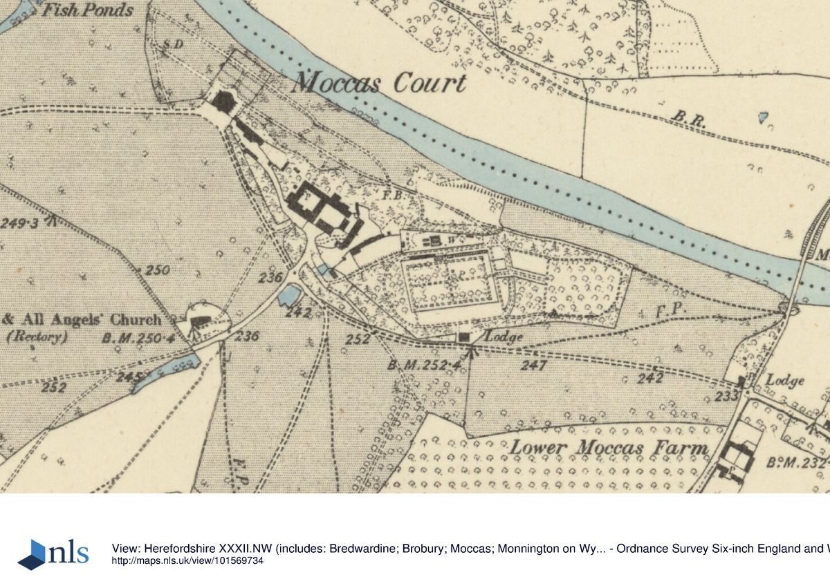
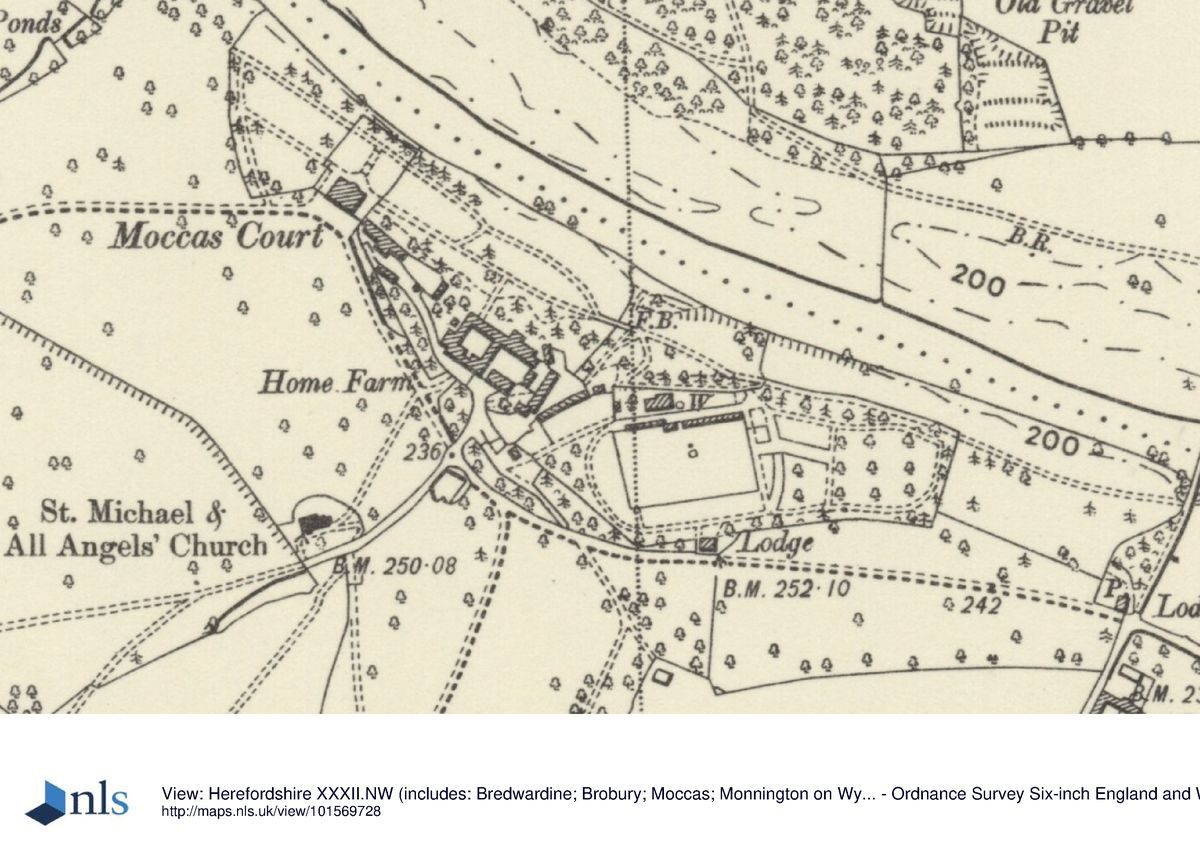
There are four approaches to Moccas. From the south a 700m long drive runs on a straight line to south of the Home Farm. At its end is the gothick, single-storey, rubble-stone Moccas Lodge (formerly Dawe Lodge, listed grade II), built in 1801 to a design from John Nash's office. The iron gate piers and gates are probably also early C19. The same office, and perhaps George Repton, also supplied the design for Bridge Lodge (listed grade II), built in a similar style in 1804 on the east side of the park and guarding approaches from Moccas to the south and from Blakemere and Hereford to the east. Again, early C19 iron gates and gate piers terminate the two drives, while the lodge garden contains several old yews. Midway along the drive west from Bridge Lodge, and south of the kitchen garden, a pair of semi-detached two-storey brick lodges was built in the later C19. The third approach is from the west, along a curving 1km long track, partly tree lined towards its west end. A drive along roughly that line was among Brown's proposals of 1778. Park Lodge, at its west end, is a three-bay, two-storey, brick, early to mid C19 building with a hipped roof. Each of these three approaches delivers the visitor to the south of the house, concealing the view across the Wye. The fourth approach was from Monnington to the north-east, crossing the River Wye via a ferry until Moccas bridge was built in 1868. That bridge was undermined by floods and demolished a century later leaving only the stone abutments. From Monnington the drive runs west along Monnington Walk before turning south to Moccas bridge. Two lodges of the third quarter of the C19 lie at the end of the Walk and where the drive turns off it, with a third to the north of Moccas bridge. Once across the river the drive, which is iron railed and partly lined with conifers, runs up to Bridge Lodge.
PRINCIPAL BUILDING
Moccas (listed grade I) was rebuilt between 1775 and c 1785 under the supervision of Anthony Keck, a local architect, the design derived in part from one submitted in 1775 by Robert Adam (1728-92). It is a relatively simple four-storey house of brick with stone dressings, designed internally around a central staircase and with a drawing room with projecting bow to the north-east matched by a bowed entrance to the south, the latter added in 1792.
The stables (elements listed grade II*), Home Farm (listed grade II) and estate buildings (variously listed grade II and II*), mainly of 1783-4 and probably also by Keck, lie c 150m to the south-east of the house. The Norman parish church of St Michael and All Angels (listed grade I) lies 200m south-west of the house.
GARDENS AND PLEASURE GROUNDS
On the south side of the house a railed gravel court separates Moccas Court from its park. The gardens and pleasure grounds lie north of the house, dropping down to the River Wye, and extending to east and west along the river bank. Immediately behind the house a series of three narrow grassed terraces with flights of steps to the centre lead to the scarped slope to the River Wye. Ashlar walls bound the terraces to east and west. Low iron gates lead from the lowest terrace to a terraced walk along the top of the slope to the river. To the west this leads into a plantation west of the fishponds at the end of the ha-ha, while to the east it leads past the plantations (in the late C20 largely subsumed in commercial coniferous woodland) around the kitchen garden to the drive south of Moccas bridge. From these walks views are enjoyed along the Wye, most dramatically to Brobury Scar to the west, one of the views at Moccas painted about 1790 by Thomas Hearne. The walks, and possibly terraces, are believed to derive, at least in part, from suggestions made by Humphry Repton between 1793 and 1795 although without a formal Red Book. A 'walk above the river' was under construction in 1793-4. Those walks replaced a linear Walk shown on a map of 1772. Contemporary sources suggest a ridge of ground (the whereabouts of which is uncertain) was lowered as a result of Repton's suggestions to improve the view to the river and Brobury Scar.
About 200m east of the house the riverside walk crosses a small ravine or valley running down to the Wye via a high footbridge supported on stone piers and with Chinese-style wooden rails. The valley is planted with shrubs and ferns, and has a ruinous icehouse cut into its east side. The valley was first bridged in 1786, and was made into a rock and water garden after the First World War.
To the south-east of the house is a sunken lawn with C17 sundial and bench, developed in the later C20 on the site of a demolished service range. That area is screened to north and south by a shrubbery and yews which extend east to partly screen the stables and Home Farm buildings; in the C19 that screen also extended around the kitchen gardens, but other than to the north that planting had been removed by the late C20. The shrubbery is probably that created in the late C18 by Sir George Cornewall, while a line of ancient yews is that which appears as The Walk on the 1772 estate map.
PARK
About 15ha around the house and including the Home Farm and kitchen garden are enclosed within a ha-ha, the line of which is continued to the north of the house by a chain of three small fishponds. That area, effectively forming an inner park, extends principally to the west and north of the house. West of the house the ground is largely open, giving a view to the deer park. Ridge and furrow underlies the permanent grassland. The northern part of this inner park is fairly densely planted with old sweet chestnuts and oaks. These may be among the 300,000 oaks reportedly planted on the estate between the mid 1790s and 1836 by Mr J Webster, the gardener and forester.
The ha-ha was constructed in 1786, when the park was enlarged following proposals by Lancelot Brown in 1778. Also imparked at that time was former farmland extending between the chain of fishponds and the loop of the River Wye to the north, and between the ha-ha to the west of the house and the existing Little Park. As mapped in 1772 Little Park occupied a rectangular block of land c 800m long from south-west to north-east and 250m wide running north-east from the Blakemere to Bredwardine road, today bisected by the drive to the house from Park Lodge. This area is well studded with mature specimen trees in permanent grassland.
North of the River Wye, the drive which crossed Moccas bridge led to Monnington Walk, a straight and flat 2km long and 50m wide ride or walk aligned on Monnington church and Manor which lie 200m east of its east end, and extending westwards to Brobury Scar, east of Brobury village. The Walk, said to have been laid out in the late C17 by Sir Thomas Tomkyns (although in the late C19 a tree ring count suggested a date of 1628), runs approximately south-west to north-east and parallel with the Wye, which lies c 500m to the south of the centre of the Walk (opposite Moccas Court), but within 100m of its west end. The Walk is accessible from Monnington village, past a large, mid C19 lodge. The edges of the Walk are lined with mature yews and Scots pine (noted in 1875 by Kilvert (Plomer (ed) 1944)), roughly alternate Maritime pines and by recently planted Austrian pines. The Monnington estate was the first and largest of Sir George Cornewall's purchases of land and enabled the extension of the park across the river, although not until exchanges of 1805 was he able to complete a circuit which crossed the Wye via the ferries at Brobury Scar and Monnington Oak.
The western half of Monnington Walk is hidden from Moccas Court by a low, wooded hill, Monnington Coppice, which was among the land purchased in 1775. It seems likely that additional plantings were made on the hill in the late C18, intended to provide the main picturesque view in the middle ground as seen from the north front of the house and its garden. At the west end of the coppice is Brobury Scar, a red cliff which here forms the north bank of the Wye. Part of the Scar was among Cornewall's purchase of 1775.
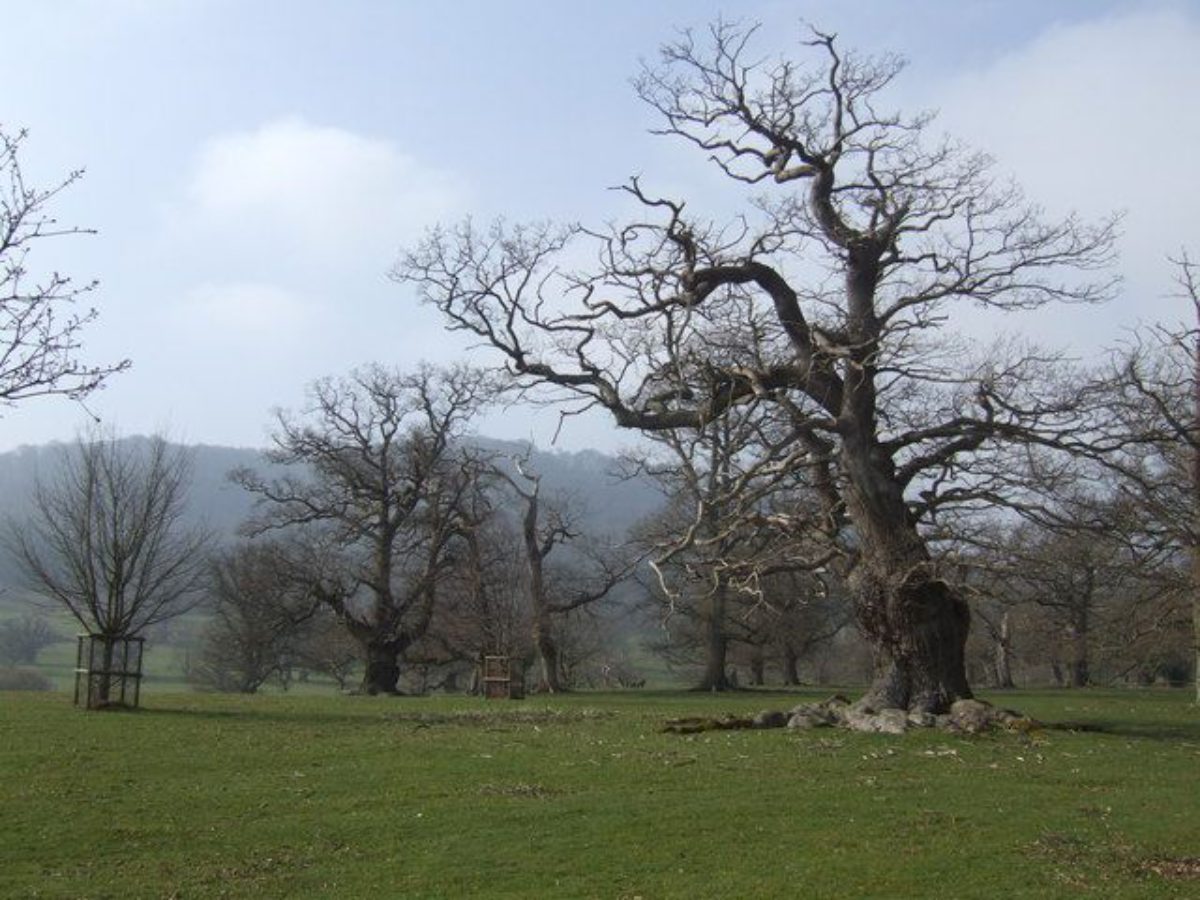
West of the Blakemere to Bredwardine road is Moccas Deer Park. On the road, at the northern corner of the park, is Lawn Gate Lodge, a one-and-a-half-storey brick building, probably built in 1787. Along the road the park is bounded by wooden palings, while to the east, south and west the boundary is largely formed by a 2m high stone wall, sections of which survive especially well on the west side. The deer park occupies a roughly circular tract of land which rises from c 75m to the north-east around Lawn Pool to c 275m to the south-west where the boundary runs along the wooded, Old Red Sandstone ridge of Dorstone Hill. The park divides into two broad zones, the Lower and Upper Parks. To the north-east the Lower Park comprises mainly open grassland with mature trees, predominantly veteran oaks (some on former field boundaries pollards) and sweet chestnuts but with a few beech and even coniferous exotics such as Wellingtonia. Here the ground is relatively flat, and Lawn Pool provides water for the park's herd of fallow deer. This, a large, irregular pool with fen and carr woodland, probably represents a late C18 enlargement of a much smaller pond mapped in 1772. Ridge and furrow occurs over most of this level zone. The Upper Park lies above the bracken line, where the ground begins to rise more steeply. There are large numbers of mature and veteran trees, notably sweet chestnuts possibly of later C17 date, some of them planted in straight, formal lines, and oaks and beeches of the late C18 and early C19. To the north-west and south-east sides of the Upper Park are blocks of commercial coniferous woodland. Below Dorestone Ridge the ground becomes more rugged and rises very steeply. There is heavy bracken cover, and a dense cover of mature trees, predominantly oaks. Several quarries and at least one limekiln are known.
The origins of the deer park are uncertain. It is possible that when created, whether in the Middle Ages or as late as the C16, it was a part of Dorstone, only becoming linked to Moccas in the mid to late C16. In the C17, when it is first documented, it probably extended from south of Lawn Pool to the lane c 400m south of Lodge Farm, although by the later C18 the southern boundary ran immediately south of Lodge Farm. A further strip of land c 400m wide was removed from the south of the park c 1800 as part of Sir George Cornewall's estate improvements, the land incorporated in adjoining farms, and the modern boundary along the ridge established. That loss was balanced by the incorporation c 1800 of the area called The Lawn, including Lawn Pool, within the park. What might be termed amenity planting, of sweet chestnuts, took place probably in the later C17, while many of the largest trees in the park were planted in the late C18 and early C19 as its picturesque character was enhanced. The park wall is also part of Cornewall's improvements. In the late C20 the park covered c 138ha (340 acres) and had a herd of c 180 fallow deer. It is considered one of the five most important areas of relict wood pasture in England.
KITCHEN GARDEN
The walled kitchen garden lies south-east of the Home Farm. Measuring c 100m east/west by c 60m north/south the main garden is bounded by 3-4m high stone-capped brick walls, probably late C18. North of the wall are contemporary sheds and shelters. The interior of the garden is occupied by commercial woodland. Against the north wall are the brick foundations of a small glasshouse.
REFERENCES
W Plomer (ed), Kilvert's Diary (1944), pp 283, 304-5
D Stroud, Capability Brown (1975), pp 233-4, pl 58
Country Life, 160 (18 November 1976), pp 1474-7; (25 November 1976), pp 1554-7
R Sidwell, West Midland Gardens (1981), pp 69-70
G Carter et al, Humphry Repton (1982), p 153
Trans Woolhope Naturalists' Field Club 47, (1992), p 227
Moccas Court, Herefordshire: notes on the landscaping of the deer park, (Debois Landscape Survey Group report to English Nature, May 1993)
Moccas Court, Herefordshire: notes on the landscaping of the deer park above the bracken line, (Debois Landscape Survey Group report to English Nature, December 1993)
S Daniels and C Watkins, The Picturesque Landscape (1994), p 84
Garden History 22, (1994), p 173
S Seymour, S Daniels and C Watkins, Estate and Empire: Sir George Cornewall's Management of Moccas, Herefordshire, and La Taste, Grenada, 1771-1819, Dept of Geography, University of Nottingham, Working Paper 28 (1994) [copy in Herefordshire Record Office (BK37)]
P T Harding and T Wall, An English Deer Park, forthcoming
Maps
OS 6" to 1 mile:
Herefordshire sheet 31 NE, 1st edition published 1886
Herefordshire sheet 31 SE, 1st edition published 1886
Herefordshire sheet 32 NW, 1st edition published 1886
Herefordshire sheet 32 SW, 1st edition published 1886
OS 25" to 1 mile: Herefordshire sheet 32.5, 2nd edition published 1904
Archival items
The Moccas Collection ((Herefordshire Record Office): including account book 1777-85, with payments re improvements to park and gardens (J56/IV/E);
Estate map, 1772 (C62/1);
Sale particulars (AW47/14);
Deeds and papers (DF93).
Description written: 1997
Register Inspector: PAS
Edited: August 1999
- Visitor Access, Directions & Contacts
Website
http://www.moccas-court.co.ukDirections
Ten miles west of Hereford via the A438, then crossing the River Wye at Bredwardine and then east on the B4352.
- History
The large deer park may be mediaeval. It became attached to Moccas in the 16th century.
In 1771 Sir George Cornewall began estate improvements, including the building of a new house by Anthony Keck from 1775, incorporating some elements by Robert Adam, and alterations to the park near the house by Lancelot Brown from 1778.
In the 1790s Humphry Repton recommended further improvements.
New lodges were built to the designs of George Stanley Repton around 1801.
The following is from the Register of Parks and Gardens of Special Historic Interest. For the most up-to-date Register entry, please visit the The National Heritage List for England (NHLE):
www.historicengland.org.uk/listing/the-list
HISTORIC DEVELOPMENT
The Cornewalls were seated at Moccas from the C17. Catherine Cornewall, the heir of Velters Cornewall, married Sir George Amyand in 1771. Under the terms of his wife's will he, a banker, merchant, and subsequently briefly MP, assumed the name Cornewall. During his lifetime he undertook a wide-ranging programme of improvements on his estate, which by purchase and exchange he enlarged from 2907 acres in 1772 to almost 7000 acres in 1818. He rebuilt the house at Moccas (from 1775), commissioned Lancelot Brown to plan improvements to the landscape (1778), rebuilt the Home Farmhouse, Stable Court and Farmyard between the house and kitchen garden (1783-4), and in the 1790s sought advice from Repton on additional improvements, acquiring land on both sides of the River Wye to enable a planting scheme to be carried out. Moccas was much admired in the late C18 and early C19; Richard Payne Knight and Uvedale Price were friends of the family; other visitors included William Sawry Gilpin, Thomas Hearne, and J C Loudon.
Sir George continued improving Moccas until his death in 1819. Subsequently there were very few changes to the landscape, although a period of neglect in the earlier C20 necessitated considerable restoration works in the mid C20.
Period
18th Century (1701 to 1800)
- Associated People
- Features & Designations
Designations
The National Heritage List for England: Register of Parks and Gardens
- Reference: GD1888
- Grade: II*
Features
- Gate Lodge
- Terrace
- Fishpond
- Ha-ha
- Icehouse
- Kitchen Garden
- House (featured building)
- Description: The house was re-built after 1775.
- Earliest Date:
- Stable Block
- Earliest Date:
- Latest Date:
- River
- Description: River Wye
- Key Information
Type
Park
Purpose
Ornamental
Principal Building
Commercial
Period
18th Century (1701 to 1800)
Survival
Extant
Hectares
312
Open to the public
Yes
Civil Parish
Moccas
- References
References
- Carter, G. et al, {Humphry Repton Landscape Gardener 1752-1818} (Norwich: Sainsbury Centre for Visual Arts, 1982), p. 153 Humphry Repton landscape gardener 1752-1818
- A Survey of Historic Parks and Gardens in Herefordshire
- {English Heritage Register of Parks and Gardens of Special Historic Interest}, (Swindon: English Heritage, 2008) [on CD-ROM] Historic England Register of Parks and Gardens of Special Historic Interest
- Stroud, D., {Capability Brown} (London: Faber, 1975), pp. 233-4, plate 58 Capability Brown
- Sidwell, R., {West Midland Gardens} (Gloucester: Sutton, 1981), pp. 69-70 West Midland Gardens: the gardens of Hereford & Worcester, Shropshire, Staffordshire, Warwickshire and West Midlands
- Harding, P; Wall, T {Moccas Court: an English deer park. The history, wildlife, management of the first parkland National Nature Reserve} (2000) Moccas Court: an English deer park. The history, wildlife, management of the first parkland National Nature Reserve
- Debois Landscape Survey Group {Moccas Court, Herefordshire: A History of the Landscape} (2003) Moccas Court, Herefordshire: A History of the Landscape
- {Moccas Court:NNR Management Plan} (2010) Moccas Court:NNR Management Plan
- Related Documents
-
CLS 1/795
Hard Copy.
-
CLS 1/795