Introduction
Mapperton House has formal gardens of around 2.5 hectares created in 1927, with additional farmland and woodland of around 32 hectares. The gardens proceed in three main terraced areas for about 250 metres north-south. The quality of the gardens is related to the fine progression, southwards and downhill, from the detailed formal layout to the wider and informal landscape.
Terrain
The site overlooks a narrow valley running north-south for about 700 metres, down which the 20th century gardens are laid out.The following is from the Register of Parks and Gardens of Special Historic Interest. For the most up-to-date Register entry, please visit The National Heritage List for England (NHLE):
Formal gardens of 1919-27 laid out by Mrs Ethel D M Labouchere at the medieval manor house of Mapperton, based on the layout of a pre-1840 garden, surrounded by parkland dating from the mid- to late C19.
Location, Area, Boundaries, Landform and Setting
Mapperton House, a site of c 22 ha, is situated c 3.5km to the south-east of Beaminster. The house is set on a plateau to the west side of a steep valley through which a small stream runs in a southerly direction. The terraced, walled gardens are laid out in this valley, the stream feeding its two ponds. To the east the gardens are framed by a series of hills, forming a dramatic backdrop to the gardens below it, and to the south-east by Parsonage Coppice. The southern part of the site is bounded by Batcombe Coppice, Bentover Coppice, and Ryland's Copice. To the west the site is bounded by farmland, with Keeper's Cottage situated outside the west boundary. To the north the site is bounded by a minor road to Beaminster. There are extensive views of the gardens and the house, both within the site and of its surrounding rural landscape.
Entrances and Approaches
The main approach to Mapperton House is the c 1500m long north avenue, which leads south from the road along the north boundary, on the same axis as the south avenue (the latter is also known as Field Avenue). The north avenue is lined on both sides by lime trees and a mature beech hedge, and passes the Old Rectory to its north-west (outside the area here registered), and then leads to the stable court to the west of the house. Two pairs of C18 gate piers topped with ball finials (all listed Grade II*) mark the entrance to the stable court, which has a circular lawn with a mature walnut tree in the centre, and is flanked to the north and south by the stables built in c1670 by Richard Brodrepp (each listed at Grade I).
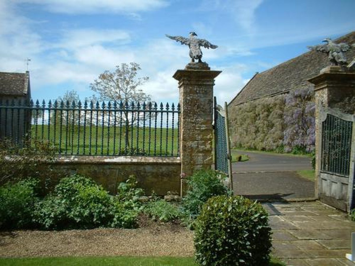
The house and its forecourt lie opposite, to the east of the stable court, separated from it by a wall, topped with spear-headed railings (CI9, listed Grade II*). The entrance in the centre of the wall is flanked by two C 18 gate piers topped with carved stone eagles (listed Grade II*).
The northern approach is first shown on the Tithe map of 1841, but does not seem to have been lined with trees at that date; the lime avenue had been planted by 1886 (OS). Some trees were replaced in the C20.
Principal Building
The manorial group, which includes the house (listed at Grade I), the attached church of All Saints (listed at Grade I), and the two stable blocks (each listed at Grade I), forms a U-shaped plan and is situated in the north-west corner of the site, with very steep grassed terraces to its east sloping down to the formal gardens. Mapperton House has an L-shaped plan and is built of ashlar stone with a stone slab and slate roof. The north range, altered under the ownership of Robert Morgan, dates from the mid C16 and includes subsequent alterations of c 1760. The east range, which contains the hall, is of similar date. The entrance front to the west, with a projecting two-storey porch, dates from the early-to mid C17 and was built by the Brodrepp family.
Attached to the south of the house is the medieval church of All Saints (listed Grade I). A doorway in its north wall gives direct access to the house. The chancel is probably C12, and the west tower dates from the CI5. The nave was rebuilt in 1704 by Richard Brodrepp. The church includes monuments to the Brodrepp family, and is surrounded by a small graveyard which includes the grave of Mrs Labouchere.
The stables west of Mapperton House are single storey with an attic above and are constructed of stone with stone slab roofs. A dovecote (listed Grade II*), built by Richard Brodrepp in the 1665 as inscribed on the door lintel, is situated c 10m south of the house. It has stone-rubble walls and stone quoins and is topped with a slate roof. Inside are approximately 300 pigeonholes.
Gardens and Pleasure Grounds
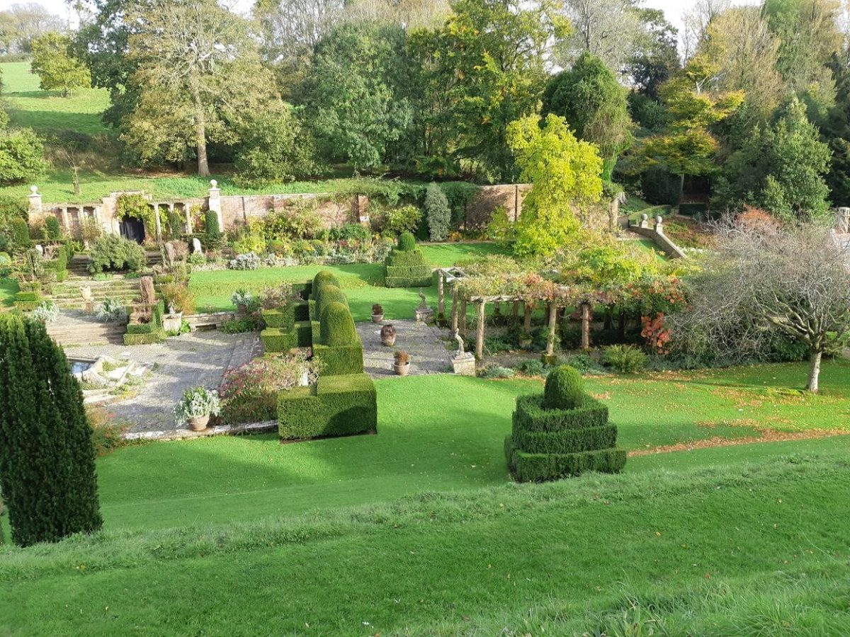
The formal gardens, covering c 1 ha, are divided into different compartments: the North Walled Garden, Fountain Court, the Pavilion Garden, Cypress Corner, and the Combe. In the south-west corner of the garden is a later gravel tennis court with a small pavilion.
The rectangular North Walled Garden lies immediately to the north of the house. It is laid to lawn and was formerly in use as a croquet lawn. It is claimed that in certain weather conditions the outline of a former parterre is visible on this lawn. It is surrounded by a planted border and a path which follows the line of C18 or C19 walls to its west (listed Grade II). The path starts in the south-west comer, where a gate in the wall gives access from the forecourt to the west of the house. It leads to a small summerhouse, built by Mrs Labouchere, which is set against the wall in the north-east comer of the garden. It has a slate roof resting on Doric columns. To the east, the North Walled Garden is bounded by a yew hedge planted in the late 1990s. From this side of the garden there are spectacular views to the south of Fountain Court and the Pavilion Garden in the valley below, which can be accessed via a flight of steps in the south-east corner of the North Walled Garden.
The Fountain Court, situated along the east boundary of the site, is enclosed by brick walls with stone buttresses to the north and east sides. It can be accessed by four flights of steps, lined with mature topiary yew trees and pedestals topped with urns, one leading from the Orangery to its north. The latter was built in the 1960s in a Classical style, and replaced a late-C19 greenhouse that stood in this location. Fountain Court comprises a rectangular central terrace with an octagonal pond with fountain, in the centre, and is surrounded by lawns. A path runs along the north and east sides of this garden, which is flanked by planted borders.
The east steps to Fountain Court lead up to a small summerhouse, built against the garden wall. It is flanked on both sides by three Doric columns and a pier topped with a ball finial, with those to the west leading to another summerhouse, topped by a stone balustrade also introduced in the 1960s, and set into the earthen bank.
The south steps lead to a rectangular paved area, with a large pergola consisting of eight square sections, constructed with wooden beams resting on stone columns on pedestals. The pergola was moved to this location from Fountain Court when the Orangery was built. Fountain Court, laid out by Mrs Labouchere, was possibly designed by the locally based architect Charles William Pike, whose son recalls his father working at Mapperton (Day 1990).
Steps to either side of the pergola give access to the Pavilion Garden below, which is dominated by two large rectangular ponds (the top one in use as a swimming pool since early 2000). Shown on the Tithe map of 1841, their origin may be of earlier date (ibid). The ponds are lined to the east and west by conical-shaped yews, planted on the steep grass banks of the valley. At the north end of the upper pond stands the Pavilion, integral with a 3m high retaining wall (listed Grade II).
The Pavilion and wall incorporate considerable earlier fabric, probably of late C17 date, suggesting it is of much earlier origin. A building and wall are marked in this position on the Tithe Map of 1841. It has been suggested these were rebuilt in the early C20 when the garden was created (Country Life 1962; Day 1990). The tall two-storey Pavilion is built of stone rubble and has a slate and stone slab roof with a barley-twist stack. The lower entrance, to the south, is marked by a rounded arch. The upper entrance, on the north side, accessed via the Fountain Court, leads into a small chamber with two pairs of stone mullion windows offering extensive views of the Pavilion Garden and the Combe extending below it, further down in the valley.
To the east of the Pavilion Garden, situated on a higher level, is a small piece of woodland (first shown on the Tithe map, 1841). A path (late C20) runs through it north from the Pavilion Garden to the Fountain Court. Halfway along this walk is a small square paved terrace, called Cypress Comer, created by Mrs Labouchere but replanted in the late 1960s. In the centre is a circular stone basin filled with water from a small stream that joins the main stream in the Combe further down the valley.
The Combe consists of a tail-like piece of informal woodland garden planted with spring flowers, and mixed trees and shrubs in the south-east part of the site. It is laid out with an upper and lower path: the upper path runs along the west bank of the valley, while the lower path follows the stream in the bottom of the valley to the east. A wooden bridge (late C20) over the stream links the two paths. The woodland is first shown on the Tithe map of 1841. It was partly felled and thinned in the late 1960s to create the informal garden and walks, and has been further developed since.
Park
Parkland encloses the gardens to the south and east and contains a number of mature trees, including a circular shaped clump of mature trees (marked on the OS map published in 1884) situated c125m east of Mapperton House. The southern half of the park is lined to its east by the south avenue (first shown on the Tithe map, 1841). Further south-east and south-west, the valley that stretches out below the gardens, splits into two grass glades screened by the woodlands of Batcombe Coppice and Parsonage Coppice and to the south-east by a mature belt of trees.
Reasons for Designation
Mapperton House is included on the Register of Parks and Gardens of Special Historic Interest at Grade II* for the following principal reasons:
- Date & rarity: it is a particularly good example of a formal Arts & Crafts style terraced garden in a rural setting.
- Quality of design: its design and layout are of a particularly high quality as expressed in the dramatic use of the natural topography of the site and its appropriateness as a setting to an exceptionally important C16 and C17 manorial group.
- Documentation and influence: the site is well documented and as evident from contemporary articles the particularly high quality of its design and planting scheme were well received.
- Group value: it has very strong group value with Mapperton House, its associated stables and other structures, all listed above Grade II.
References
Book Reference - Author: Pevsner, N and Newman, J - Title: The Buildings of England: Dorset - Date: 1972 - Page References: 266-8 - Type:
Article Reference - Date: July 1901 - Journal Title: Country Life - Volume: 10 - Page References: 16-20
Article Reference - Date: 11 October 1913 - Journal Title: Country Life - Volume: 34 - Page References: 490-5
Article Reference - Date: 4 January 1962 - Journal Title: Country Life - Volume: 131 - Page References: 18-21
Article Reference - Date: 11 January 1962 - Journal Title: Country Life - Volume: 131 - Page References: 66-9
Article Reference - Date: 25 January 1962 - Journal Title: Country Life - Volume: 131 - Page References: 176-80
Article Reference - Date: 6 January 1994 - Journal Title: Country Life - Volume: 1 - Page References: 30-3
Book Reference - Author: Oswald, Arthur - Title: Country Houses of Dorset - Date: 2nd edn 1959 - Page References: 79-82
Book Reference - Author: Paterson, A - Title: The Gardens of Britain 2 - Date: 1978 - Page References: 35-6
Other Reference - Description: Inspector's report: Mapperton House (English Heritage 1990)
Unpublished Title Reference - Author: R Day - Title: The Gardens of Mapperton House - Date: 1990 - Type: Landscape Survey
Other Reference - Description: Mapperton House Storm Damage Restoration Plan (Livingstone Eyre Associates 1991)
Map Reference - Title: Tithe Map for Mapperton Parish - Date: 1841 - Source: Dorset Record Office
Map Reference - Title: 1st edn OS 6"to 1 mile, surveyed 1884 - Date: 1886
Map Reference - Title: 2nd edn OS 6" to 1 mile, revised 1901 - Date: 1903
Other Reference - Description: Sale particulars for Mapperton House, 1919 (held by the Dorset Record Office)
Other Reference - Description: Historic photos of Mapperton c1900-01 (private collection; copies held by Dorset County Museum)
- Visitor Access, Directions & Contacts
Telephone
01308 862645Website
https://mapperton.comAccess contact details
The gardens are open between March and October excluding Saturdays. Please see: http://mapperton.com/visit-us/opening-and-admissions/ 01 308 862645
Directions
http://mapperton.com/visit-us/how-to-find-us/The gardens are signposted from Beaminster and from the A356.
Owners
Earl and Countess of Sandwich
Mapperton House, DT8 3NR
- History
The following is from the Register of Parks and Gardens of Special Historic Interest. For the most up-to-date Register entry, please visit the The National Heritage List for England (NHLE):
www.historicengland.org.uk/listing/the-list
History
As recorded in Domesday, the house at Mapperton manor was owned by William de Moion. Some one hundred years later it was owned by the Brett family, and during the C14 the estate passed to John Morgan and his family, from Stoneleigh in Devon. Mapperton remained in their ownership until 1609, when the first Richard Brodrepp (d 1737) became the new owner. The Brodrepp family held Mapperton manor from 1618 to 1788. In the late CI7, the second Richard Brodrepp started a campaign of alterations to the House, and built the north and south stables and the dovecote, however, very little is known of pre-C20 gardening at Mapperton.
During the CI8, under the ownership of the fourth and last Richard Brodrepp, the walls and gate piers to the west front were built, including the ha-ha to this side of the house. After Richard Brodrepp's death in 1744, Mapperton passed to his nephew, Bennet Combe. In 1788 Bennet's granddaughter, Catherine Richards, married John Compton. The manor thus became part of the Compton estates, with Minstead in Hampshire being the family's main home.
By 1841 (Tithe map) the south avenue had been planted, and by the late C19 (OS 1886), the park and avenue in the eastern part of the site were in place. Mapperton House remained in the ownership of the Compton family until 1919, when the estate was auctioned and bought by Mrs Ethel DM Labouchere. Between 1919 and 1927 she restored the house and created a formal Arts and Crafts style garden based on the existing mid- to late-C19 layout (Tithe map, 1841; OS 1886).
In 1955, after Mrs Labouchere's death, Mapperton House was bought by Mr Victor Montagu, who served as MP for South Dorset from 1941 to 1962. Between 1955 and 1980 he purchased additional land at Mapperton and further improved, extended, and replanted the garden with the assistance of a group of local masons, labourers, a mechanic, a gardener called R. Feek, and Colonel Lloyd, as stated on a commemorative plaque in the gardens.
The site is in private ownership (2013).
Period
- 20th Century (1901 to 2000)
- Early 20th Century (1901 to 1932)
- Features & Designations
Designations
The National Heritage List for England: Register of Parks and Gardens
- Reference: GD1391
- Grade: II*
Features
- Manor House (featured building)
- Description: Mapperton House was begun in the mid-16th century, enlarged in the early to mid 17th century, and partly remodelled in the mid 18th century.
- Earliest Date:
- Stable
- Description: There are north and south stables on the west side of the approach drive.
- Earliest Date:
- Latest Date:
- Drive
- Dovecote
- Description: A dovecote built in 1685 lies 10 metres to the south of Mapperton House.
- Earliest Date:
- Latest Date:
- Gate Piers
- Description: 18th-century gate piers with eagles lie 15 metres to the west of the House.
- Earliest Date:
- Latest Date:
- Gate Piers
- Description: Further 18th-century gate piers lie across the road between the north and south stable blocks.
- Earliest Date:
- Latest Date:
- Avenue
- Description: A lime avenue (elm until about 1960) about 250 metres from north, extends 250 metres south beyond the west front of the House.
- Ha-ha
- Description: A 20th century ha-ha lies to the west of the stables, giving onto open fields.
- Earliest Date:
- Latest Date:
- Terrace
- Description: The gardens proceed in three main terraced areas for about 250 metres north-south.
- Orangery
- Earliest Date:
- Latest Date:
- Pool
- Description: Raised pool with enclosing paving.
- Topiary
- Description: Topiary yews.
- Pergola
- Description: An extensive pergola system.
- Wall
- Description: A high retaining wall.
- Garden House
- Pool
- Description: A rectangular swimming pool.
- Topiary
- Description: Conical clipped yews.
- Tree Feature
- Description: At the southern end of the pool, 2 pairs of cylindrical yews flank a formal paved area.
- Formal garden
- Woodland
- Key Information
Type
Garden
Purpose
Ornamental
Principal Building
Domestic / Residential
Period
20th Century (1901 to 2000)
Survival
Extant
Hectares
2.5
Open to the public
Yes
Civil Parish
Mapperton
- References
References
- Newman, J and Pevsner, N {The Buildings of England: Dorset} (Harmondsworth: Penguin, 1972) pp 266-268 The Buildings of England: Dorset
- Oswald, A {Country Houses of Dorset} (1959) pp 79-82 Country Houses of Dorset
- {English Heritage Register of Parks and Gardens of Special Historic Interest} (Swindon: English Heritage 2008) [on CD-ROM] Historic England Register of Parks and Gardens of Special Historic Interest
- Stratton & Holborow {Mapperton Heritage Management Plan} (1993) Mapperton Heritage Management Plan