

Introduction
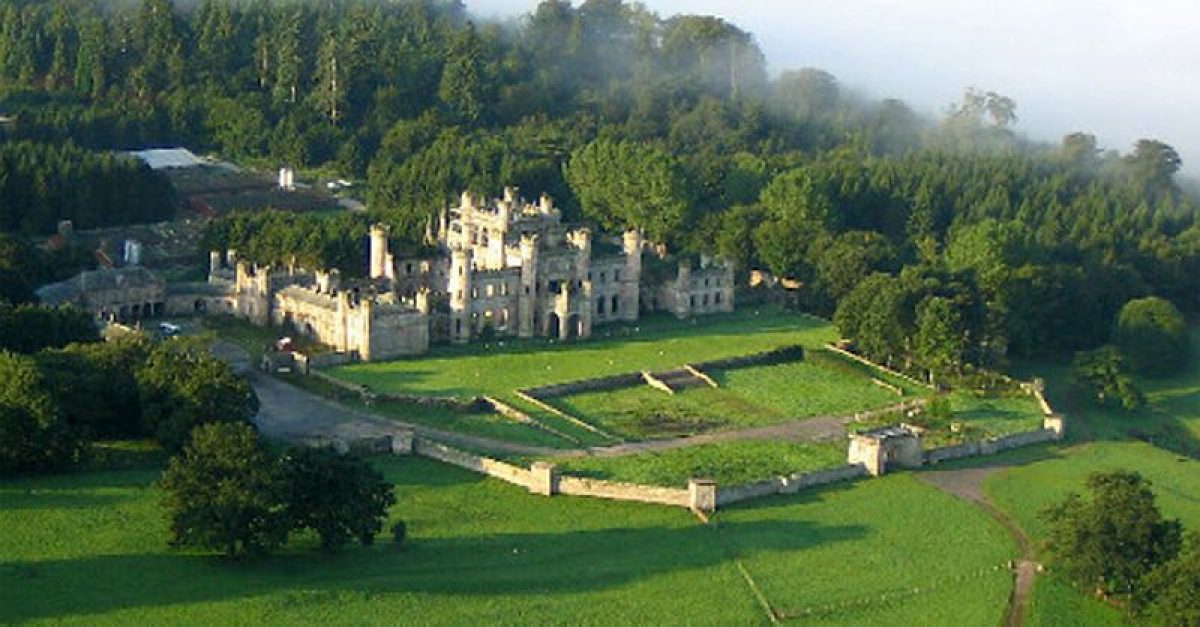
Lowther Castle has a landscape park, flanked on its western side by the river Lowther. The site covers about 600 hectares. The present building was unoccupied from 1935 until recently. Along with the gardens, the building had fallen into ruin. A new project was started in August 2007 to consolidate the castle and grounds and use them for recreation, the arts and an education centre. The restoration is now well underway and the site is open to the public.
Terrain
Slopes down to the River Lowther on the north and west sides.
The gardens were developed during the 16th, 17th, 18th and 19th centuries.
Features include tree lined avenues, a formal garden which is now overgrown, and a walled garden which is now the Lakeland Bird of Prey Centre.
The following is from the Register of Parks and Gardens of Special Historic Interest. For the most up-to-date Register entry, please visit The National Heritage List for England (NHLE):
Parkland of the C17, C18 and early C19 with medieval origins and a late C17/early C18 avenue, a terrace with early C18 or earlier origins, and an early C19 terrace and forecourt by Robert Smirke.
Location, Area, Boundaries, Landform and Setting
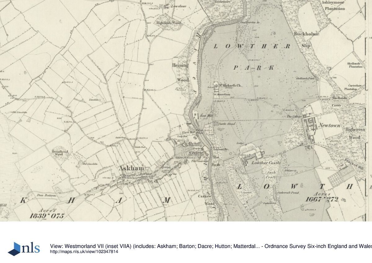
Lowther Castle is situated c 5 km south of Penrith in an area which is rural and agricultural. The c 600 ha site is on land which slopes down to the River Lowther on the north and west sides. The northern and eastern boundaries of the registered site are generally formed by woodland: on the north-west side by Heining Bank, immediately north of Askham, an avenue on the west edge of Yanwath Wood and the southern and eastern part of Yanwath Wood. The boundary then follows the outer edge of Horseholme Wood to the north, and part of Buckholme Wood and Buckholme Slip to the north-east.
To the south-east the boundary is defined first by the road between Newtown and Lowther village and then, turning south, the outer edge of Boonby Plantation. The southern boundary is formed by a track running along the edge of Decoy Hag and Rowlandfield to the hamlet of Whale. From this point the western boundary is formed by the east bank of the River Lowther as far as Askham. A public road runs through the park between Askham and Newtown.
Entrances and Approaches
The principal entrance to the site is from Askham, where the public road leads into the site over Askham Bridge on the east side of the village and runs north and then east, past Lowther church, to Newtown. This road crosses Buckholme Drive, which leads south to the Castle from Clifton and enters the registered area at Buckholme Lodge, at the north-east tip of the site. West of this a drive called Earl Henry's Drive leads south from Lowther Bridge and enters the registered site at the northern end of Yanwath Wood, crossing the River Lowther via a C20 bridge built to bypass a narrow stone bridge called Low Gardens Bridge. It then joins Buckholme Drive and continues south to the Castle.
This configuration of drives is shown on Greenwood's county map of 1824 but not on that by Jeffreys of 1770. Emperor's Drive, built in honour of Kaiser Wilhelm's 1895 visit, runs west-north-west from a gateway at the south-east tip of the site before dividing, one route leading north to Newtown and the other north-west to the Castle. The latter is not shown on the 1st edition OS map surveyed 1859, but it does appear on that published in 1898. There are a number of other private drives through the estate.
Principal Building
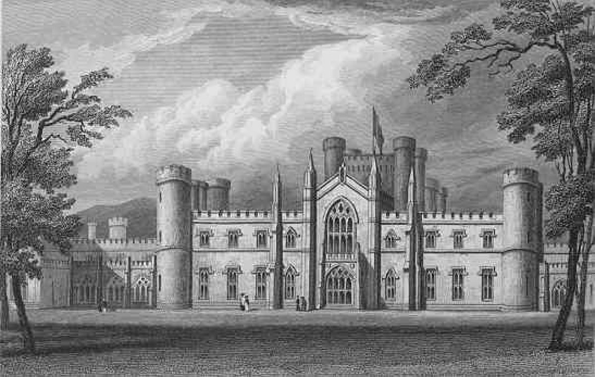
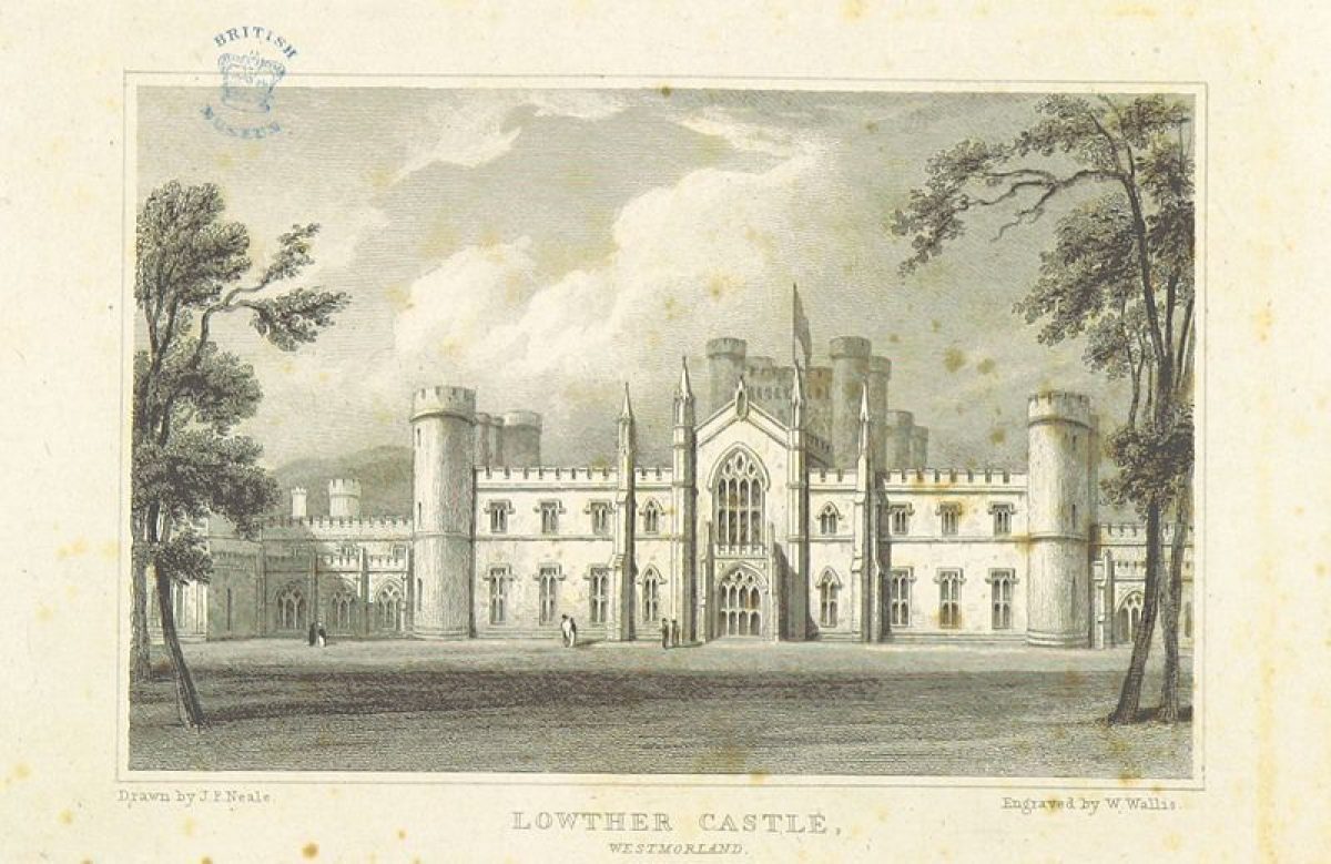
Lowther Castle (listed grade II*) was designed by Robert Smirke (1780-1867) and built 1807-14 at a cost of £77,000. The building was closed in 1935 and was stripped of its roofs and gutted in 1956-7 when the walls were capped. Attached on the east side is a stable block (listed grade II*), also by Smirke. The present building replaced a medieval pele tower which, following successive C17 improvements, was largely destroyed by fire in 1718.
It was not rebuilt until William, first Earl of Lonsdale (second creation) engaged Smirke. Successive schemes for the rebuilding of the seat at Lowther were commissioned by the owners from the late C17 to the early C19 and the collection of architectural drawings from Lowther Castle, which is one of the largest and most important of its kind, is summarised with illustrations in Colvin, Mordaunt Crook & Friedman (1980). The collection is deposited on loan to Cumbria County Council Archive Department in Carlisle.
Gardens and Pleasure Grounds
The north front of Lowther Castle overlooks a terrace and forecourt by Robert Smirke. A lodge with square battlemented turrets flanking a central arched opening (listed grade II*) is situated c 70m to the north and is aligned with the front of the Castle. On each side canted battlemented stone walls (listed grade II*) form an enclosure around the north side of the Castle and stables, and there are rectangular turrets at the angles. Central stone steps flanked by ramps lead up to a terrace (all listed grade II*) in front of the Castle.
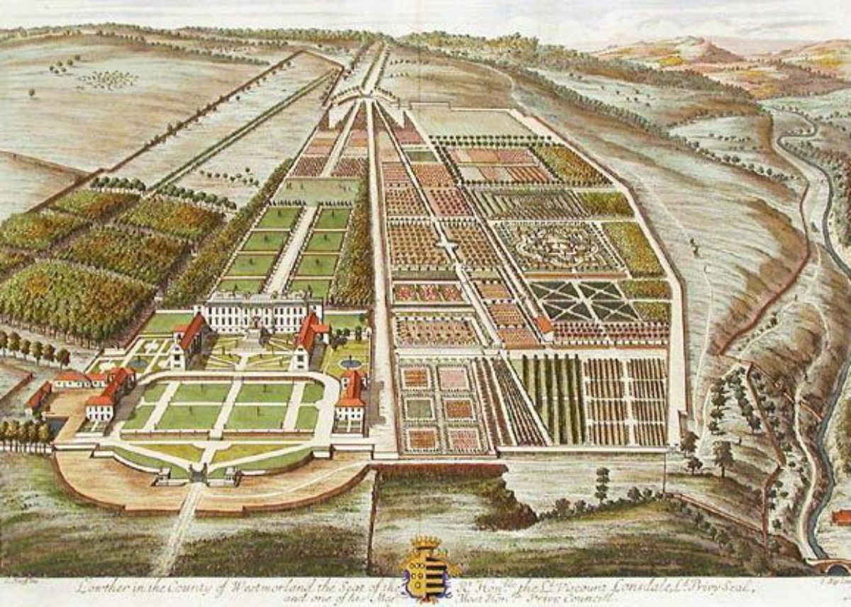
There are views from the terrace over parkland to the north and of an avenue aligned with the lodge and centre of the Castle which continues into the far distance. The terrace and forecourt are on the site of a forecourt with radial paths and formal gardens shown on an engraving of c 1700 by Knyff & Kip and on a survey plan of the Castle made after the 1718 fire. This map also shows other areas illustrated by Knyff & Kip, including an enclosed garden with a fountain marked 'Fountain Yard' and, on the west side, an area marked 'The Old Garden'.
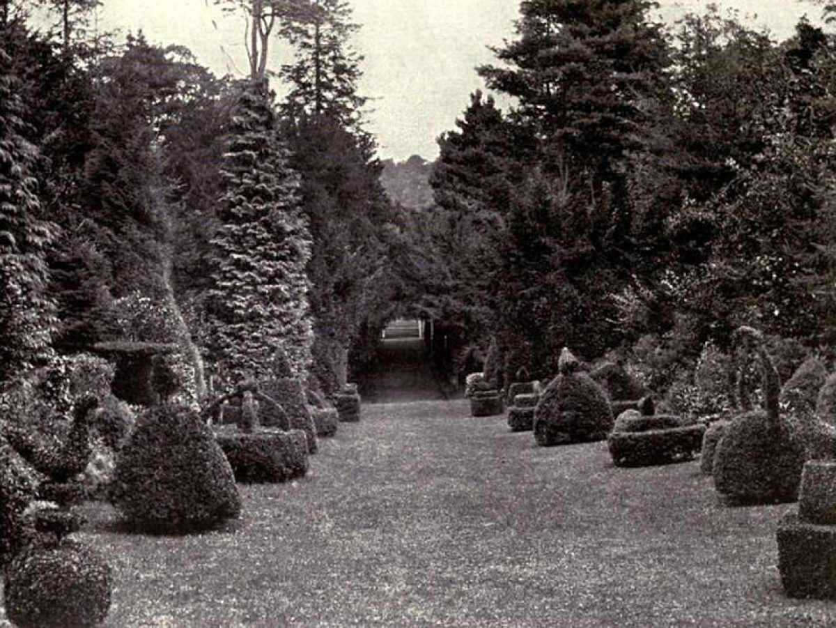
Pleasure grounds and gardens were situated to the south of the Castle in an area enclosed on the west side by a wall attached to the canted forecourt wall which turns and runs southwards, continuing as the retaining wall of a terrace for a distance of c 1km. The area is planted with conifers, replacing lawns and formal gardens laid out during the late C19 and early C20 which were destroyed during army occupation in the mid C20.
Some of the forestry tracks appear to follow garden paths as shown on the 1898 OS map. The gardens were the subject of a series of photographs in 1911 which correspond with areas shown on a plan in a pre-war guide book. The remains of a summerhouse shown on the 1898 OS map are situated c 300m south-west of the Castle, overlooking the terraced walk which extends southwards from the north end of the garden for a distance of c 1km.
The terrace is on the line of a natural scarp called Burtree Scar which continues through parkland for a distance of c 500m. The terrace is suggested on Jeffreys' county map of 1770 and is on the line of a walk shown on the engraving of c 1700 by Knyff & Kip. This engraving shows elaborate formal gardens south and south-west of the Castle, and estate papers record Sir John Lowther spending £1500 on planting by 1697.
Kitchen Garden
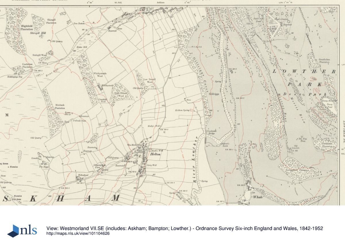
The kitchen garden is situated c 800 m south-east of the Castle and is reached from a drive running south from the public road to Lowther village. This leads into a walled enclosure with glasshouses along the north wall and a single-storey cottage at the west end. There is an arched opening in the north wall west of the glasshouses. The south wall has a range of bothies and other ancillary buildings now (1997) used as a café and as exhibition space.
An arched opening leads into a second walled enclosure with a glasshouse along the western part of the north wall. There are opposed arched entrances at the northern ends of the east and west walls. The southern wall has been demolished, and the garden is divided by an east/west brick wall with a central opening which has been reduced in height on both sides and is topped by ball finials. The east and west walls continue beyond this but the area has been fenced along the line of the dividing wall and the area to the south is in use as pasture land. The 1859 OS map shows that the garden extended to the west as an orchard. The garden is currently (1997) in use as the Lakeland Bird of Prey Centre and it contains cages and demonstration areas.
Park
The Castle is situated north of the centre of an elongated, sub-rectangular area of parkland. An avenue extends from the Castle's north forecourt up rising land on the western edge of Yanwath Wood for a distance of c 1.8 km. It is shown in a painting of c 1725 by Matthias Read (Harris 1979). There are three other avenues in the northern part of the park; one follows the line of Buckholme Drive and was planted during the C20 and another of similar date runs along the public road between Newtown and Askham. The third avenue, which is shown on the 1859 OS map, ran parallel to and c 300 m to the east of Buckholme Drive, extending c 600 m north of the public road. An avenue shown on an estate map of 1732 and the 1770 county map ran parallel to and south of the public road.
The River Lowther runs along the western side of the northern part of the park and then curves east at a point c 800 m north-west of the Castle in an area called Low Gardens, where a natural amphitheatre is formed by the fall of the land to the riverbank. Some 200m north of this there is an Iron Age earthwork called Castlesteads (scheduled ancient monument) in Yanwath Wood. The river turns north-eastwards through woodland called Mitchell Holme and Horseholme Wood.
Thomas Wilkinson (1751-1836) laid out paths along the riverbanks in Yanwath Woods in 1804 and subsequent years. The area to the north of the Castle was not imparked until the late C18 or early C19; the main avenue is shown on the estate map of 1732 running through enclosed land. Greenwood's county map of 1824 shows parkland extending north as far as the river and the 1859 OS map shows it extending north to Buckholme Lodge and along each side of the river.
The southern part of the park is a mixture of open land with scattered trees and areas of woodland and plantations. A pond called Decoy Pond, c 1.5 km south-east of the Castle, is overlooked from its eastern bank by a hunting lodge called Decoy House, which is possibly of C18 or earlier origin. This is immediately west of an area of woodland called Decoy Hag, and the pond and Decoy Hag are within a roughly oval area shown on an estate map of 1685 as a park. Earthworks and ditches within woodland in this area probably relate to the boundaries of the earlier medieval park.
The 1685 park boundary survives in various places in the form of wall footings. At the southern tip of the park there is an area called Rowlandfield Plantation which is walled on the south and north-east side. This is shown on the 1685 map and is mentioned by the second Sir John Lowther in a memoir of 1640 (quoted in Capsticks 1995) in which he states that his father walled Rowlandfield as well as repairing the walls around areas described as the Old and New Parks. Lancelot Brown (1716-83) visited Lowther on two occasions, in 1763 and 1771 and produced plans similar to those for Croome Court in Worcestershire (qv), which were not executed.
In 1807 John Webb (c 1754-1828) also prepared a design which may have been partially executed, but it is not possible to relate the features of the park and the pattern of planting as shown on the 1859 OS map to his design with any confidence. It seems likely that landscaping was undertaken when the parkland was extended to the north which happened some time between 1770 and 1824. A painting by J M W Turner of 1809 (Harris 1979) does not show the principal avenue, perhaps as a result of artistic licence, but if it was removed as proposed by both Webb and Brown, it had been replanted on the same line by the time Jan De Wint painted the scene c 1835 (ibid).
Kitchen Garden
The kitchen garden is situated c 800 m south-east of the Castle and is reached from a drive running south from the public road to Lowther village. This leads into a walled enclosure with glasshouses along the north wall and a single-storey cottage at the west end. There is an arched opening in the north wall west of the glasshouses. The south wall has a range of bothies and other ancillary buildings now (1997) used as a café and as exhibition space.
An arched opening leads into a second walled enclosure with a glasshouse along the western part of the north wall. There are opposed arched entrances at the northern ends of the east and west walls. The southern wall has been demolished, and the garden is divided by an east/west brick wall with a central opening which has been reduced in height on both sides and is topped by ball finials. The east and west walls continue beyond this but the area has been fenced along the line of the dividing wall and the area to the south is in use as pasture land. The 1859 OS map shows that the garden extended to the west as an orchard. The garden is currently (1997) in use as the Lakeland Bird of Prey Centre and it contains cages and demonstration areas.
Other Land
Lowther church (listed grade II*) is situated c 700m north-west of the Castle. The building is of Norman origin, rebuilt and remodelled on a number of occasions. The rectangular churchyard is entered at its south end where there are C17 gate piers (listed grade II). Some 60m south of the church there is a mausoleum (listed grade II), dated 1857, for William, second Earl of Lonsdale. The western side of the churchyard is formed by a retaining wall along the edge of a scarp which drops steeply down to the River Lowther.
Maps
- Survey plan of Lowther after the fire of 1718, in Colvin et al 1980, pl 5
- L Brown, A Plan for the intended Alterations at Lowther Hall, 1763, in Colvin et al 1980, pls 19-20
- T Jeffreys, The County of Westmorland, 1770
- J Webb, A Plan of the Park and Demesne Lands at Lowther, 1807, in Capsticks 1995
- C & J Greenwood, Map of the County of Westmorland, 1824
- Estate maps of 1685 and 1732 are discussed and partially transcribed in Capsticks 1995
- OS 6" to 1 mile:
- 1st edition surveyed 1859
- 2nd edition published 1898
- OS 25" to 1 mile: 1st edition surveyed 1860
Archival items
- The Lowther papers (D/Lons) are held by the Cumbria Record Office, Carlisle
Description written: August 1997 Amended: June 1998
Register Inspector: CEH
Edited: March 1999
- Visitor Access, Directions & Contacts
Access contact details
The gardens are open daily from 10am. Please see:
Directions
4 miles south of Penrith
- History
The site of Lowther Castle has been occupied since the 13th century. In 1720 Lowther Hall burnt down and was replaced in 1806 to 1811 with the present building.
In 1935 the family moved out because the upkeep of the building and grounds had become too expensive. They moved into Askham Hall, also in Cumbria, in the 1950s.
The gardens were developed during the 16th, 17th, 18th and 19th centuries.
In August 2007, following the steady decline of the site, the Lowther Castle and Gardens Trust was formed. They are heading a new project for the site. The Trust plans to consolidate the castle and grounds and use it for recreation, the arts and education.
The following is from the Register of Parks and Gardens of Special Historic Interest. For the most up-to-date Register entry, please visit the The National Heritage List for England (NHLE):
www.historicengland.org.uk/listing/the-list
HISTORIC DEVELOPMENT
Lowther was the seat of the Lowther family from the C12 until the mid C20. Hugh Lowther was granted a licence to enclose 200 acres of land as a park in 1337. In 1682 Lowther village, which was situated between the main house and Lowther church, was purchased by Sir John Lowther and pulled down. The parkland was successively augmented and it reached its greatest size, when it covered more than 3000 acres, under the fifth Earl of Lonsdale (1857-1944). The Castle and much of the park were used for training by the army in the Second World War and the Castle is currently (1997) maintained as a controlled ruin.
- Associated People
- Features & Designations
Designations
The National Heritage List for England: Register of Parks and Gardens
- Reference: GD1659
- Grade: II
The National Heritage List for England: Listed Building
- Grade: II*
Features
- Tree Avenue
- Earliest Date:
- Latest Date:
- Hall (featured building)
- Description: Lowther Castle (listed grade II*) built 1807-14 aand gutted in 1956-7
- Earliest Date:
- Latest Date:
- Terrace
- Description: An early-19th century terrace and forecourt.
- Earliest Date:
- Latest Date:
- River
- Description: River Lowther.
- Lodge
- Description: Lodge with square battlemented turrets flanking a central arched opening (listed grade II*)
- Gardens
- Parkland
- Description: Parkland of the C17, C18 and early C19 with medieval origins
- Kitchen Garden
- Church
- Description: Lowther church (listed grade II*) is of Norman origin,
- Mausoleum
- Description: Mausoleum (listed grade II), dated 1857
- Hunting Lodge
- Description: Decoy House, which is possibly of C18 or earlier origin.
- Key Information
Type
Park
Purpose
Ornamental
Principal Building
Domestic / Residential
Survival
Part: standing remains
Hectares
600
Open to the public
Yes
Civil Parish
Lowther
- References
References
- {English Heritage Register of Parks and Gardens of Special Historic Interest} (Swindon: English Heritage 2008) [on CD-ROM] Historic England Register of Parks and Gardens of Special Historic Interest
- The Landscape Agency {Lowther Parkland Conservation Plan} (2002) Lowther Parkland Conservation Plan
- The Landscape Agency {Lowther Conservation Management Plan for the Landscape and Gardens} (2007) Lowther Conservation Management Plan for the Landscape and Gardens
- pl 41 Britannia Illustrata, Vol. 1
- pl 65 A Series of Picturesque Views 2
- p 42 Formal Gardens in England and Scotland
- pls 87-93 The Gardens of England in the Northern Counties
- A Short History of Lowther and the Lowther Family, Guidebook
- p 153 The Artist and the Country House
- Related Documents
-
CLS 1/81/334
Hard copy
-
CLS 1/994/1
Restoration and Management Plan - Preliminary Study, Survey and Analysis - Hard Copy
Hilary Taylor Landscape Associates Ltd with The Landscape Agency - 2002
-
CLS 1/458
The Castle and Gardens of Lowther, Cumbria: Conservation Plan - Hard copy
The Landscape Agency - 2002
-
CLS 1/459
The Castle and Gardens of Lowther, Cumbria: Conservation Plan: Appendices - Hard copy
The Landscape Agency - 2002
-
CLS 1/460
The Castle and Gardens of Lowther, Cumbria: Conservation Plan: Character Area Illustrations - Hard copy
The Landscape Agency - 2002
-
CLS 1/81/334