Introduction
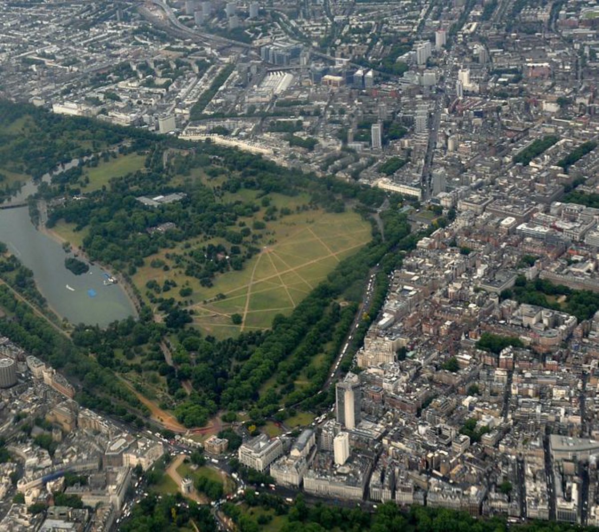
A public park which was originally a medieval deer park, Hyde Park features walks, lawns, flower beds and water features including the Princess Diana Memorial Fountain. Kensington Gardens was separated from the original park in the 18th century, and Hyde Park now occupies an area of about 142 hectares (130 hectares registered).
Terrain
Gently undulating, falling generally from north t.o south.
The following is from the Register of Parks and Gardens of Special Historic Interest. For the most up-to-date Register entry, please visit the The National Heritage List for England (NHLE):
www.historicengland.org.uk/lis...
A royal deer park from the C16 to C17, subsequently becoming a public amenity. Major changes and improvements made by Decimus Burton from 1820.
NOTE This entry is a summary. Because of the complexity of this site, the standard Register entry format would convey neither an adequate description nor a satisfactory account of the development of the landscape. The user is advised to consult the references given below for more detailed accounts. Many Listed Buildings exist within the site, not all of which have been here referred to. Descriptions of these are to be found in the List of Buildings of Special Architectural or Historic Interest produced by the Department of Culture, Media and Sport.
SUMMARY DESCRIPTION
Hyde Park is situated in west London immediately to the east of Kensington Gardens (qv). Regent's Park (qv) is c 1.5km to the north and Green Park (qv) c 250m to the east. The gently undulating c 130ha park falls generally from north to south and is bounded to the north by Bayswater Road. Park Lane provides the boundary to the east and the South Carriage Drive the boundary to the south. Constructed in 1736 as the King's New Road, by 1827 the South Carriage Drive, along with Outer Ring, the East, North, and West Carriage Drives, the Serpentine Road, and the construction of the Serpentine Bridge, provided a circuit of the park. The opening up of new entrances around the perimeter of the park as it became increasingly adopted for use by the public inevitably increased the number of paths. Since 1924 when taxis were first allowed into the park traffic has been on the increase and has also constituted the chief threat to the actual extent of the park. On the east side, Park Lane has been widened several times since the 1860s.
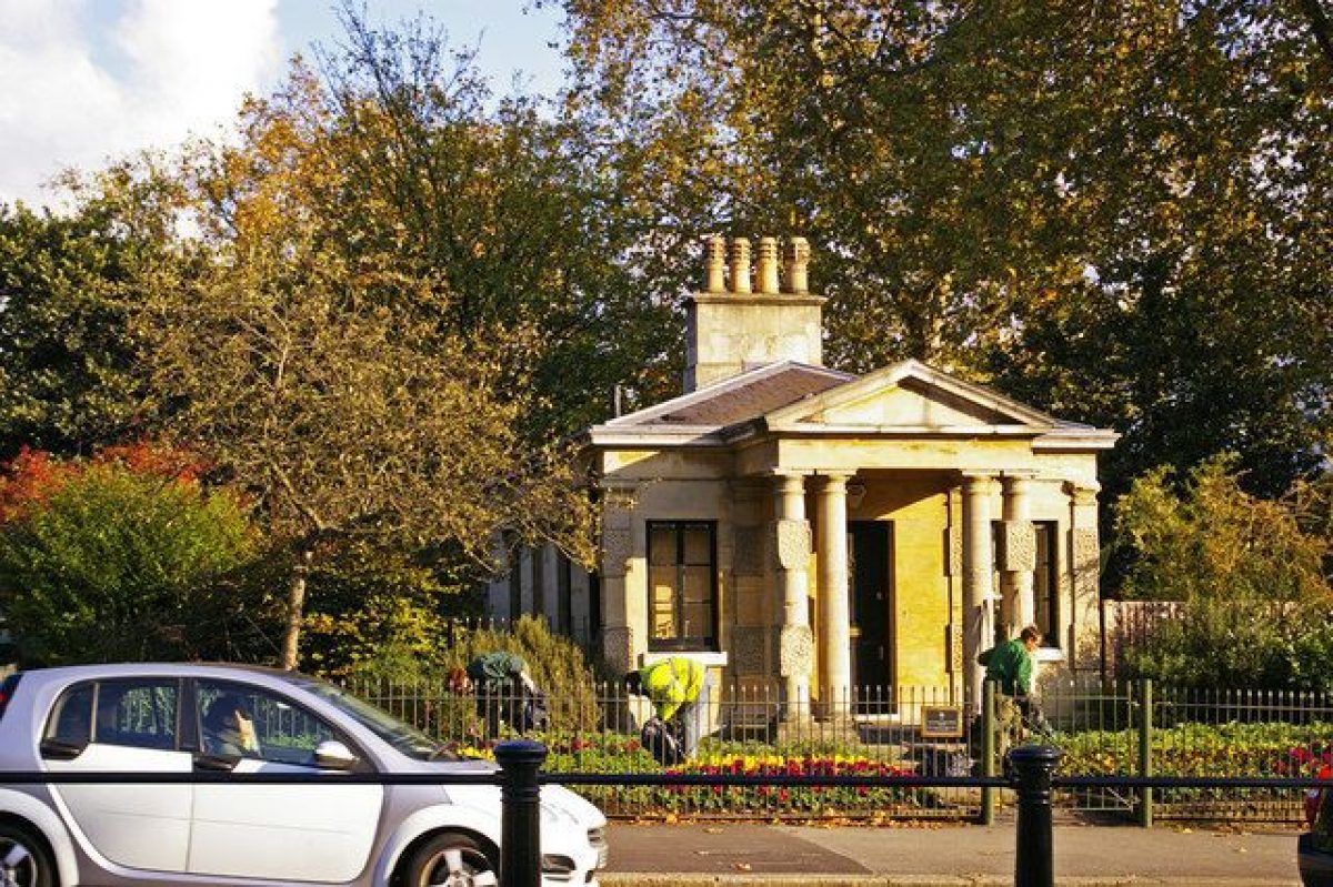
Numerous gates and lodges provide entrances to the park, the majority of which are listed grade II and date from the C19. The most decorative entrance is the Queen Elizabeth Gate constructed in the late C20 and situated in the south-east corner of the park, providing an entrance from Hyde Park Corner and the southern end of Park Lane.
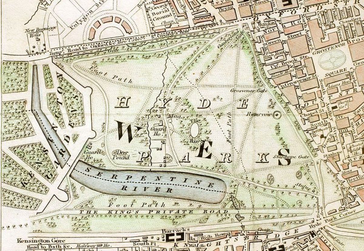
The park, laid mainly to grass, is crossed by a number of paths which radiate from the gates and from points within the site. Tracks and walks were introduced by the early C17 and by the mid C17 the Tour (the Ring) was a fashionable venue for riders and carriages in the centre of the park. The first recorded road was the Route de Roi (Rotten Row), which runs east/west to the south of the site. Completed in 1690 following the Crown's acquisition of Nottingham House (Kensington Palace), it provided the king with a direct route between the Palace and Whitehall and was the first lamp-lit road in England. The Row was itself supplanted by the King's New Road (South Carriage Drive) in 1736 but continued as a popular public bridleway, now (1999) extended to the east and the north. One of the most controversial changes to the park, associated with the International Exhibition of 1862 which was held in South Kensington, was the southern extension of the West Carriage Drive over the Serpentine Bridge (listed grade II) to provide a connection between Victoria Gate to the north and Alexandra Gate, a new carriage gate, to the south. This required the filling in of the southern section of Bridgeman's ha-ha and subsequently the road line was adopted as the boundary between Hyde Park and Kensington Gardens. Although only intended as a temporary measure the road quickly became a major thoroughfare.
The park focuses on the Serpentine which lies towards the south-west side of the site. The park was formerly watered by the Westbourne, a minor tributary of the Thames which flowed from Hampstead. The plan of 1706 attributed to Henry Wise (1653-1738) shows a string of ten pools, these being linked up to form the Long Water in 1727 and the broader, longer Serpentine in 1731. Made under the supervision of Charles Wither, the then Surveyor General of His Majesty's Woods, the Serpentine was separated from the Long Water by a small cascade which was replaced in 1826-8 by the Serpentine Bridge, built by George Rennie. At the east end of the water is the Dell, a roughly triangular depression, the south side formed by an irregular embanked flower bed. This is now (1999) a picturesque spot where a piece of Cornish limestone, part of a former drinking fountain erected in 1861, survives. The Dell is situated in a large hollow which is a remnant of a small lake created in 1730. Originally this pool stretched to the present edge of the park and was bridged by Rotten Row and the King's New Road. In 1844 Thomas Cubitt (1788-1855) reduced its size by infilling the area to the south of Rotten Row and in the 1880s the Dell was designed with a tropical layout. On the south bank of the Serpentine is the Lido. It was created by George Lansbury, First Commissioner of Works in c 1930 in memory of Capt J Cooper to whom a plaque was erected on the Lido pavilion in 1931. The new Lido allowed mixed bathing for the first time and was reconstructed between 1951 and 1953. At this time the Lansbury Memorial plaque was erected in memory of the founder. Rotten Row runs almost parallel to the south bank of the Serpentine and between the Row and the South Carriage Drive is the site of the Crystal Palace erected as part of the Great Exhibition of 1851. Almost opposite the Lido on the north bank of the Serpentine are three boathouses. One is a late C20 facility for the boating concession and includes floating pontoons to allow the public access to hired boats. There are two older boathouses, one erected in 1902 by the Royal Humane Society and the other erected in 1952 to replace one damaged during the war. Boating has been allowed in the Serpentine and the adjoining Long Water since 1847.
To the north of the boathouses there is a complex of buildings. These include the Superintendent's House, the Ranger's Lodge (listed grade II), and the Old Police Station. In a secluded hollow to the north of these buildings is a bird sanctuary surrounding the nursery where bedding plants for the parks are raised.
In the north-east corner of the park is Speaker's Corner; it was after the Reform League riots of 1866 that a place in Hyde Park was specially designated for meetings and on Sundays it is still (1999) a popular place for public oratory.
REFERENCES
N Cole, Royal Parks and Gardens of London (1877), pp 19-24
N Braybrooke, London Green (1959), pp 49-100
B Cherry and N Pevsner, The Buildings of England: The Cities of London and Westminster (1973), pp 589-91
Hyde Park, Historical Survey: Report for Royal Parks Agency, (Land Use Consultants 1982)
G Williams, Royal Parks of London (1987), pp 64-77
Georgian Group J VII, (1997), pp 75-93
Maps [reproduced in LUC 1982]
Henry Wise (?), Kensington Palace and Gardens ad Hyde Park, c 1706, Work 32/312
J Rocque, Kensington Palace and Gardens and part of Hyde Park, 1736
C and J Greenwood, Map of London, surveyed 1824-6, published 1827
J Mann, Kensington Gardens and Hyde Park, surveyed 1840, published 1846
OS 25" to 1 mile:
1st edition published 1869
2nd edition published 1894-6
3rd edition published 1916
Description written: November 1999 Amended: October 2001
Register Inspector: LCH
Edited: January 2002
- Visitor Access, Directions & Contacts
Telephone
0161 275 7129Access contact details
The park is open from 5am to midnight daily. Please see:
https://www.royalparks.org.uk/... or telephone 020 7298 2100
Directions
Tube: Hyde Park Corner, Knightsbridge (Piccadilly); Marble Arch, Queensway, Lancaster Gate (Central). Bus: 2, 8, 9, 10, 12, 14, 16, 19, 22, 36, 38, 73, 74, 82, 94, 137
Owners
Royal Parks Agency
- History
The following is from the Register of Parks and Gardens of Special Historic Interest. For the most up-to-date Register entry, please visit the The National Heritage List for England (NHLE):
www.historicengland.org.uk/lis...
HISTORIC DEVELOPMENT
The agricultural land that became Hyde Park belonged to Westminster Abbey before 1536 when Henry VIII acquired it by compulsory exchange for a priory in Buckinghamshire. Henry enclosed the park in 1540 and used the land to extend his hunting grounds which by this time included the Leper Hospital (later St James's Park qv), Marylebone Park (later Regent's Park qv), and the districts around his Palace of Westminster. Military reviews took place from the time of Elizabeth I and from the early C17 limited public access was permitted. Several enduring features were established including the Tour, later renamed the Ring, the first ornamental feature of the park. The Ring is mentioned as the focus of fashionable life by 1635 and its introduction points to the change in emphasis away from hunting and military exercising towards more leisurely pursuits. In 1652 when the Parliamentarians were in control of the country they divided Hyde Park into five parts totalling c 250ha, and sold them to three purchasers. Many of the mature trees were felled and when, following the Restoration, the park was taken back into royal ownership it was described as a 'barren field'. The grounds were reopened to the public, a brick wall was built around the park, and it was restocked with deer.
Major changes came in the reign of William III who in 1689 acquired Nottingham House at the eastern edge of the park and began to form Kensington Palace. Development of the park continued under Queen Anne and Queen Caroline (wife of George II). Between 1690 and 1736 land was appropriated in the western half of Hyde Park for the creation of formal gardens for Kensington Palace and by 1736 these had been extended to the present boundary which was defined by the ha-ha wall built by Charles Bridgeman (d 1738) in 1730. The remaining part of Hyde Park had few formal features: a plan of c 1706 (Wise) shows only the Walnut Avenue at the eastern end, adjacent to Park Lane, and the Ring, and numerous small rectangular plantations alongside the King's New Road, the Route de Roi (now known as Rotten Row), the formal axis created by William III in 1690. Rides and paths meandered across the park. In 1725 George I allowed the Chelsea Water Works Company to build an ornamental reservoir inside the central circle of the Walnut Avenue. It was built to meet the anticipated needs of the now greatly enlarged Palace and gardens at Kensington. East of the ha-ha the Serpentine was formed.
During the late C18 and early part of the C19 the Crown ceased to be interested in the park and its character was left to develop largely in response to the demands of the public who resorted there to ride, drive, fish, and skate. By the beginning of the C19 the increasing housing developments around the park and the existence of a local community created new demands including the need for easy pedestrian access. Lord Euston, Park Ranger between 1794 and 1807, drew attention to the poor general condition of the park and it was he who cut down the decaying Walnut Avenue and planted, according to his claims, 25,000 new trees in Hyde Park and the neighbouring St James's Park. He also constantly complained to the Treasury and to the Office of Works that all the structures in the park were in an appalling state (LUC 1982).
The improvements carried out in the 1820s were the most extensive programme of works undertaken in Hyde Park. The scheme was designed by the architect Decimus Burton (1800-81), with the assistance of the road builder James McAdam, under the overall supervision of the Office of Works. Burton reorganized the Park Lane side of the park, substituting iron railings and a belt of trees for the former brick wall and creating new entrances and lodges. The scheme of improvements included the resiting of the Marble Arch. Originally intended as a triumphal entrance to Buckingham Palace and the official memorial to the Napoleonic Wars, the arch was moved to the north-east corner of Hyde Park, near the Cumberland Gate entrance, to form an entrance to the top of Park Lane and the west end of Oxford Street (Georgian Grp J 1997).
The occasion of the Great Exhibition in 1851 can be seen as the starting point of the development of the Victorian Hyde Park (LUC 1982). The exhibition is best remembered for the Crystal Palace, the exhibition hall designed by Joseph Paxton and moved, in 1852, to Sydenham (Crystal Palace Park qv). The C20 has seen the park continue to develop along the lines laid down by the Victorians. George Lansbury, as First Commissioner of Works between the wars, greatly improved recreational facilities in all the Royal Parks, with funds raised by public appeal in 1929. During the Second World War the park was adapted to serve a number of purposes. Air-raid shelters were provided at the eastern edge of Park Lane and anti-aircraft defences, including three barrage-balloon emplacements and an anti-aircraft battery, operated from 1941 to 1944. Barracks were constructed along the main ride leading north from the Serpentine Dam and extensive allotments were situated along the south side of the park.
Dutch elm disease destroyed the remaining old elms in the park from the 1950s onwards and although much replanting has been undertaken in places this does not reflect the grandeur of the pattern of the original schemes. In the 1960s the area adjacent to Park Lane was subjected to major alterations caused by road improvements to Park Lane. The doubling in size of the road took 8.5ha out of the park and destroyed Burton and McAdam's carriage road inside the eastern perimeter.
Today (1999) the park remains a public open space and is managed by the Royal Parks Agency.
- Associated People
- Features & Designations
Designations
Conservation Area
- Reference: Royal Parks
The National Heritage List for England: Register of Parks and Gardens
- Reference: GD1808
- Grade: I
Site of Local Importance for Nature Conservation
Style
English Landscape Garden
Features
- Boating Lake
- Description: Serpentine lake.
- Ornamental Fountain
- Outdoor Swimming Pool
- Key Information
Type
Park
Purpose
Recreational/sport
Principal Building
Parks, Gardens And Urban Spaces
Survival
Extant
Hectares
140
Open to the public
Yes
- References
References
- {English Heritage Register of Parks and Gardens of Special Historic Interest} (Swindon: English Heritage 2008) [on CD-ROM] Historic England Register of Parks and Gardens of Special Historic Interest
- Cherry, B and Pevsner, N {The Buildings of England: London 1: The Cities of London and Westminster} (Harmondsworth: Penguin, 1973) pp 589-591 The Buildings of England: London 1: the Cities of London and Westminster
- Land Use Consultants {Hyde Park historical survey: tree survey} (1982) Hyde Park historical survey: tree survey
- Land Use Consultants {Hyde Park historical survey: tree survey} (1982) Hyde Park historical survey: artefact schedules
- Colvin and Moggridge {Hyde Park Management Plan} (1996) Hyde Park Management Plan
- Land Use Consultants {Hyde Park Strategic Management Plan} (1999) Hyde Park Strategic Management Plan
- Kim Wilkie Associates {Hyde Park Corner: Turning the Corner} (2001) Hyde Park Corner: Turning the Corner
- Land Use Consultants {Hyde Park Management Plan 2} (2002) Hyde Park Management Plan 2
- Land Use Consultants {Hyde Park Management and Maintenance Plan} (2003) Hyde Park Management and Maintenance Plan
Contributors
London Parks and Gardens Trust
- Related Documents
-
CLS 1/286/1
Hyde Park Management Plan - Digital copy
Colvin and Moggridge - 1983
-
CLS 1/285/2
Royal Parks Historical Survey - Digital copy
Land Use Consultants - 1982
-
CLS 1/286/1