Introduction
Holkham Hall is a Palladian-style mansion surrounded by an 18th- to 19th-century park, woodland and agricultural estate. It is considered to be one of the principal landscape parks in England. The parkland contains monuments and landmarks, including an obelisk, a lake and a stretch of coastline.
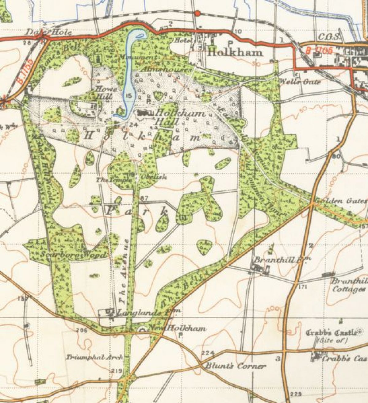
Holkham Hall is a Palladian-style mansion surrounded by an 18th- to 19th-century park, woodland and agricultural estate of 1210 acres, considered to be one of the principal landscape parks in England. The estate now comprises 25 tenanted farms which make up 6100 hectares, and an extensive deer park which contains nearly 1000 fallow deer. The grounds and parkland that immediately surround the hall, built between 1734 and 1764, cover 3000 hectares and feature numerous walks. The parkland contains monuments and landmarks, including an obelisk, a lake and a stretch of coastline.
The following is from the Register of Parks and Gardens of Special Historic Interest. For the most up-to-date Register entry, please visit The National Heritage List for England (NHLE):
One of the principal landscape parks in England, laid out by Thomas Coke (later the Earl of Leicester), Lord Burlington, and William Kent, with Matthew Brettingham in the early to mid C18 and greatly extended in the late C18 and early C19. Lancelot Brown, William Emes, and Humphry Repton, who produced a Red Book in 1789, are all associated with the site. The mid C19 garden terraces are by William Burn, William Andrews Nesfield, and Thomas Sandys.
NOTE This entry is a summary. Because of the complexity of this site, the standard Register entry format would convey neither an adequate description nor a satisfactory account of the development of the landscape. The user is advised to consult the references given below for more detailed accounts. Many Listed Buildings exist within the site, not all of which have been here referred to. Descriptions of these are to be found in the List of Buildings of Special Architectural or Historic Interest produced by the Department of Culture, Media and Sport.
SUMMARY DESCRIPTION
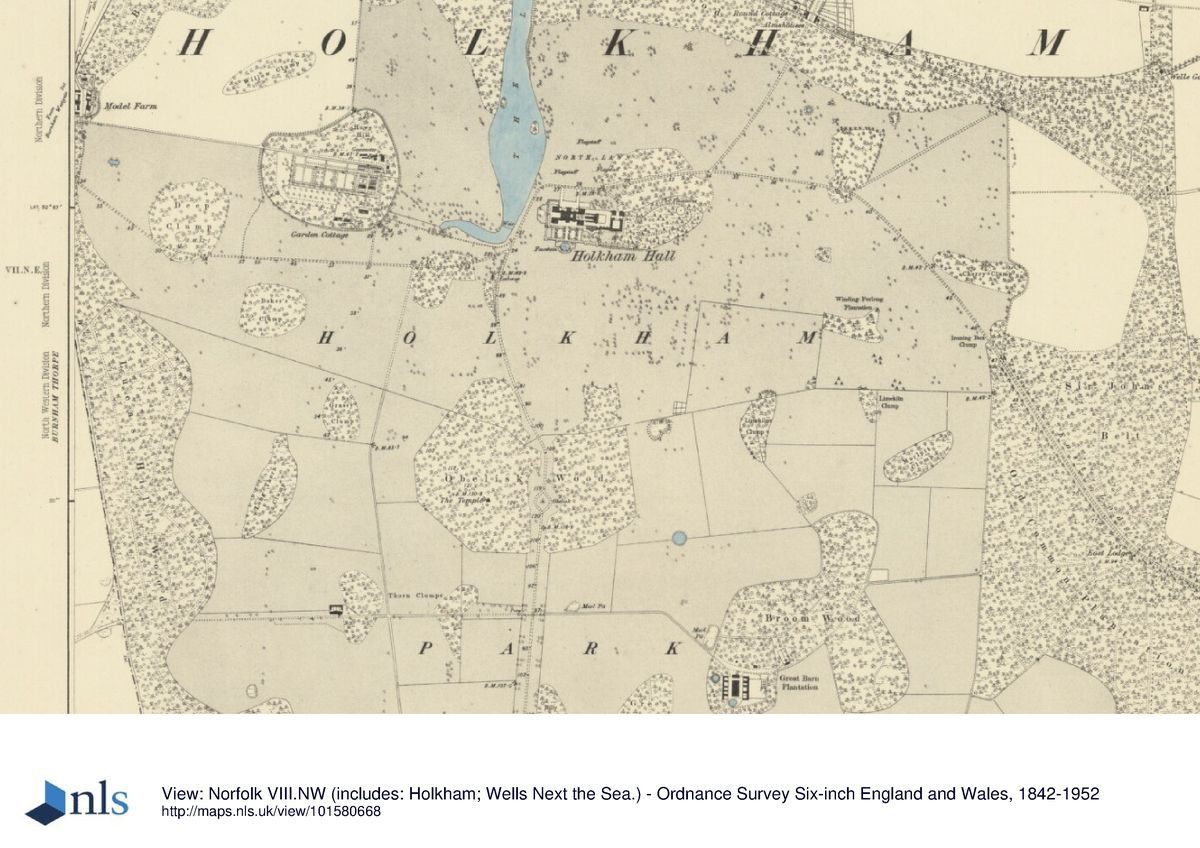
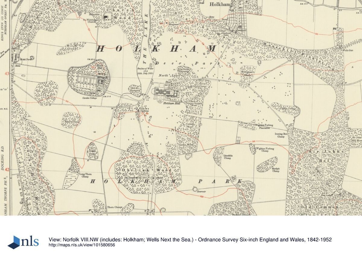
Holkham Hall sits on the open expanses of the north Norfolk coast, immediately to the south of the main A149 coast road between Hunstanton and Cromer. The park is located c 3km west of Wells-next-the-Sea and covers an area of c 1210ha, measuring c 4km north/south and c 3km east/west. It is completely surrounded by a brick and flint park wall, and screened by boundary woodlands, belts and plantations which enclose an open park laid (1999) to pasture in the north and farmed as arable in the south. The ground has an overall and gentle slope down towards the sea c 2km north of Holkham Hall, which is sited in the northern centre of the park. Views within the park are associated with the main north/south axis along which the avenue, Obelisk, Hall, and Monument are arranged. A second major view is contrived from the Temple in Obelisk Wood, looking north along the length of the lake. St Withburga's church, 1km to the north-west of the Hall, acts as a focus in the landscape scheme, being set upon a high hill looking down over the park and lake. There are also many minor views enjoyed from various points in the park, although most of the vistas created in Obelisk Wood have long been removed.
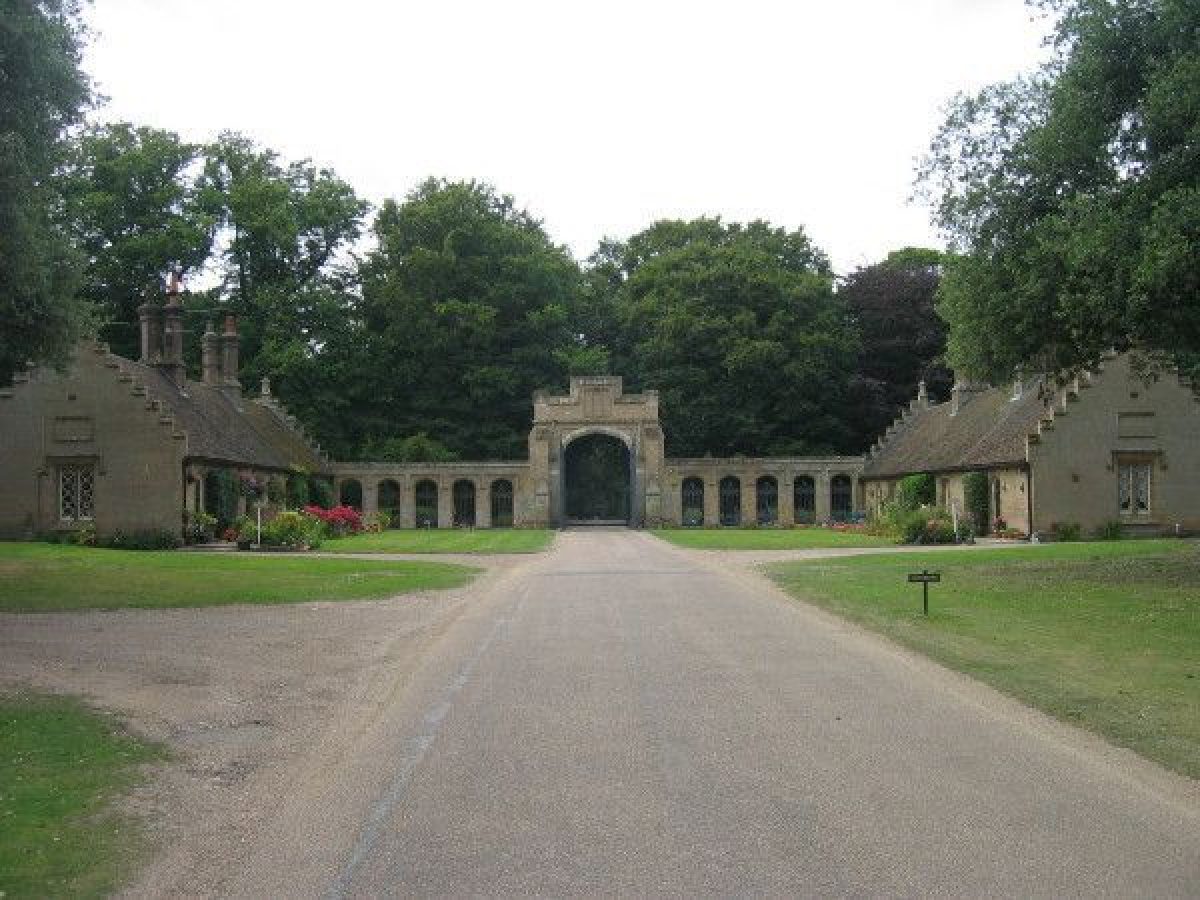
The main entrance is from the north, off the coast road 1km north of the Hall, past mid C18 almshouses, the Octagon Cottages (Wyatt), and through Teulon's gothic screen. The drive turns west through the park to arrive at the stable block and north front of the Hall. A second drive enters from the south, past the twin lodges 3km south of the Hall, the drive running north for c 2km along The Avenue, past the Obelisk, before dropping down along the western edge of the south lawn and skirting the west front of the Hall to the main entrance court. The west lodge drive enters the park due west of the Hall, by the model farm and passes south of the walled garden to join the south drive west of the Hall (lodge by Wyatt). Midway along the northern boundary stands Church Lodge (Wyatt), its drive, now a grass track, passing between the west bank of the lake and St Withburga's church before entering the open park. There are numerous other lodges and entrances: along the eastern boundary are Wells (or East) Lodge (Wyatt) on the north-east corner; a further lodge by Mousehill Plantation; Palmers Lodge (Wyatt) at the west end of Golden Gate drive; the Golden Gate Lodge 1km south of Wells Lodge; and Cuckoo Lodge 400m south-east of Golden Gate Lodge. Branthill Lodge (Wyatt) stands midway along the south-east boundary 2.2km south-south-east of the Hall; and Scarborough Lodge on the southern edge of Scarboro Wood 2.2km south-south-west of the Hall.
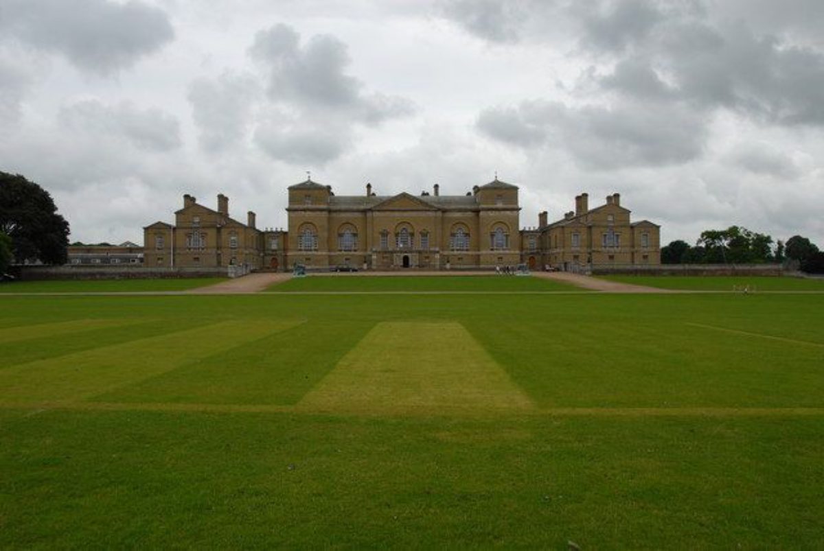
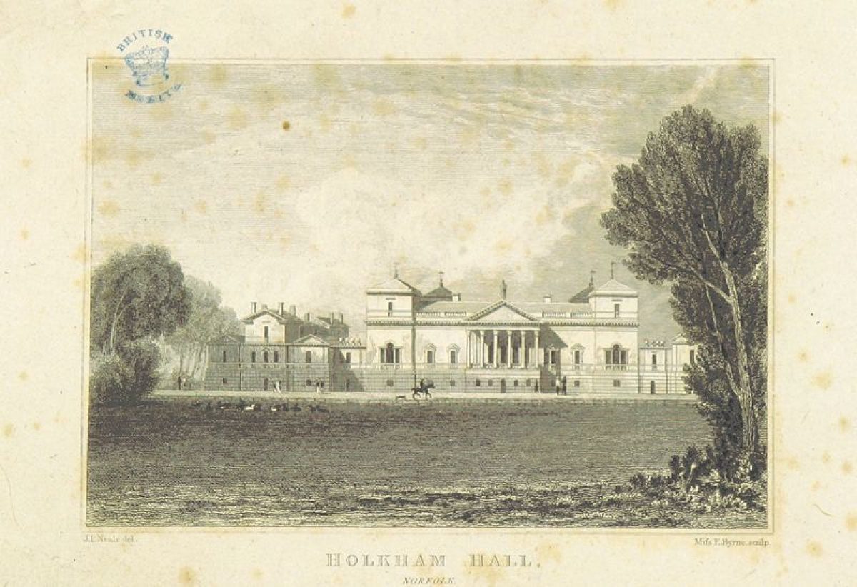
Holkham Hall (listed grade I) is a grand country mansion built of Holkham gault brick of exceptional quality with slate roofs. It is arranged as a Palladian villa on an enlarged scale with a rusticated ground floor, a single main floor above the rustic, and four low wings or pavilions, one on each corner, the garden front to the south having the addition of a central hexastyle Corinthian portico above the ground floor. In 1722 'Mr Tallman', presumably the architect William Talman, was paid to produce drawings, and two years later Colen Campbell did the same. Neither set of drawings survive and the actual design of the house came out of a collaboration between Thomas Coke, Lord Burlington, and William Kent, although it was executed and completed by Matthew Brettingham the Elder, whose drawings are dated 1726. It has remained largely unaltered since its original construction.
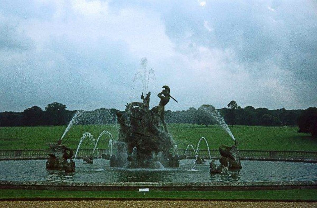
The gardens at Holkham lie to the south and west of the Hall. They comprise formal terraces decorated with box parterres and scroll work. The south terrace extends east/west for 300m with a central walk and fountain with sculpture (Charles R Smith) 110m to the south, a garden temple at the east end, and an orangery (Wyatt) on the east end of the Hall. They were laid out in the mid C19 by William Burn and William Andrews Nesfield. The pleasure ground and shrubbery lies to the east of the Hall and was originally laid out by Kent in the mid C18, with later alterations by Lancelot Brown in 1762 and further plantings by Nesfield in the mid C19.
The creation of the park began in 1722, in advance of the building of the Hall. Those parts of the park which were always pasture, principally the northern and central sections, remain (1999) under grass, whilst the north-west section and the park south of Obelisk Wood continue to be farmed as arable. There are relatively few free-standing trees within the park, but of these a number date from the C18, especially in the area to the north of the Hall: these are mainly oaks, beech, and sweet chestnut. A pollarded oak to the north-east of the Hall, another to the south of the icehouse, and a pollarded ash in the east park, represent survivors from the pre-park landscape. Much early planting remains in the outer belts which continue to encircle the park. The earliest sections, the woods planted in the middle decades of the C18 around the northern end of the lake, survive well whilst the remainder, planted by Sandys in the late C18 and early C19 contain much original planting, as do the large clumps he established. The park is entirely enclosed by a brick and flint perimeter wall.
To the north of the Hall is a sweep of grass running up to a monument and bounded to the west by the lake. This area is known as the North Lawn, an area of open grass with scattered tree clumps on either side, some of which date from William Kent's period of planting, originally of mixed species but now consisting only of beech. The monument is dedicated to Thomas William Coke, and was raised on the site of Kent's north lodge in 1845. The North Lawn was levelled and planted with a pattern of clumps to one of Kent's designs, framing the north lodge, between 1753 and 1755. The formal elements of the landscape were further softened later in the century as the basin south of the Hall and the serpentine river were filled in and the Seat on the Mount removed. The lake was given a bend at its northern end by William Emes in 1784, and another at the southern end in 1801-3 by John Webb.
To the south of the formal gardens lies the great South Lawn, a stretch of grass recently (1990s) replanted with parkland trees, framing the view to the Obelisk which stands at the end of the southern avenue, within Obelisk Wood. A classical Temple stands within Obelisk Wood, built between 1729 and 1735, at the same time as the Obelisk was erected at its centre. The South Lawn was laid out between 1724 and 1729 as part of a grand scheme by William Kent. Formal lines of trees were planted on either side, framing a vista towards Obelisk Wood which was planted on the summit of a hill and contained a far more complex pattern of allées than exist today (1999), focused on the Temple and framing vistas of distant objects in the landscape. Kent also dammed the Clint, a natural water course which ran close to the Hall, to form a lake between 1725 and 1731 and excavated a geometric basin to the south between 1730 and 1735. He added 'porches' ( small classical pavilions ( beside the basin in 1732-6 at the ends of the formal lines of trees running up the hill to Obelisk Wood. Kent created the area to the south of the Hall and its pleasure grounds as a piece of miniaturised, idealised Italian scenery, the main feature of which was a 'New Mount', created in 1742; the temple-like 'Seat on the Mount' was constructed the following year. Of his work, all that survived the changes of the late C18 and C19 were the South Lawn, and the Temple and Obelisk in Obelisk Wood. The late C17 icehouse was also retained on the rising ground to the south of the lake.
The walled kitchen garden lies c 800m west of the Hall, with a gardener's house and free-standing vinery beside it. It is presently (1999) used as a commercial plant centre. The walls enclose an area of c 3ha with a further 1ha of orchard to the south. The garden is divided into two long compartments by high brick walls running east/west; the southern one in turn is divided into four equal spaces, and the northern one into two spaces, one small and one large. The two compartments at the eastern end contain C19 ranges of glass, cold frames, gardeners' stores, and forcing beds together with some old espalier fruit trees. The large compartment to the north is used as a growing area for the nursery whilst the smaller southern compartments contain mixed planted borders, plant display areas, and remnants of old orchards. The garden was moved to its present site in the 1780s and built, along with the cottage and vinery, to designs by Samuel Wyatt.
REFERENCES
Note: There is a wealth of material about this site. The key references are cited below.
Country Life, 3 (1 January 1898), pp 752-4; 143 (16 May 1968), pp 1310-14; 167 (24 January 1980), pp 214-17; (31 January 1980), pp 298-301
J Lees-Milne, Earls of Creation (1962), pp 244-7
D Stroud, Humphry Repton (1962), pp 36-8
N Pevsner, The Buildings of England: North-west and South Norfolk (1962), pp 199-204
Apollo 150, (August 1974), pp 133-6
D Stroud, Capability Brown (1975), p 229
Garden History 6, no 2 (Summer 1978), pp 22-5
G Carter et al, Humphry Repton (1982), p 159
S Wade-Martins, Holkham Park: its development over three centuries (1983)
J Garden History 11, (1991), nos 1 and 2, pp 56-8
T Williamson, The archaeology of the landscape park, BAR Brit Ser 268 (1998), pp 59-72, 100-05, 197-9, 212, 245-7
Maps
T Clerke, Description of the lordshipe or mannor of Holkham ..., 1590 (private collection)
Undated proposal map of Holkham park, c 1745 (private collection)
Undated map of Holkham park, c 1760 (private collection)
C Biedermann, A survey of lands at Holkham, 1781 (private collection)
W Faden, A new topographical map of the county of Norfolk, 1797 (Norfolk Record Office)
A Bryant, Map of the county of Norfolk, 1826 (Norfolk Record Office)
OS Surveyor's draft drawings, c 1815 (British Library Maps)
OS 6" to 1 mile: 1st edition published 1886
Archival items
The majority of the original documents and maps relating to Holkham are held in a private collection.
Description written: March 1999 Amended: February 2000
Register Inspector: EMP
Edited: March 2001
- Visitor Access, Directions & Contacts
Telephone
01328 710227Website
https://www.holkham.co.uk/Access contact details
For detailed visitor information visit the Holkham Hall website.
- History
The following is from the Register of Parks and Gardens of Special Historic Interest. For the most up-to-date Register entry, please visit the The National Heritage List for England (NHLE):
www.historicengland.org.uk/listing/the-list
HISTORIC DEVELOPMENT
In 1609 Sir Edward Coke, Lord Chief Justice in the early C17, acquired some land in Holkham and through his son's marriage to Meriel Wheatley the family came to live at Hill Hall, the precursor of the present Holkham Hall. The history of the designed landscape at Holkham effectively begins with Thomas Coke, who inherited the estate in 1707 at the age of ten. Having completed the Grand Tour, during which time he received some formal architectural training and met William Kent, he returned to England in 1718 to marry and set about rebuilding the hall at Holkham. The earliest surviving drawings are by Matthew Brettingham, dated 1726, and construction began in 1734, to a modified Brettingham design which is believed to have been developed by Coke himself, Lord Burlington, and William Kent, with Brettingham contributing the construction details.
By 1734, when building of the new hall commenced, a large geometric landscape, organised around a main north/south vista, was already taking shape, the formality of which was further emphasised by the planting of the great south avenue in 1735, and the erection in 1738/9 of the south lodge at the point where this entered Obelisk Wood. By this time however new ideas were affecting the design of the landscape and a number of innovative features began to appear. These were of a new, serpentine character and were largely the work of William Kent, whose activities at Holkham had, up to this time, been largely concerned with the design of garden buildings. The area to the south of the Hall was redesigned and a new shrubbery and pleasure ground created. The southern end of the lake was given a more irregular outline, an island was created, and in 1742 the water was connected by a 'serpentine river' to the basin south of the Hall. A pale was gradually erected enclosing a park of c 360ha and much planting was undertaken between the 1730s and 1750s, taking the form of large blocks of woodland and small skyline clumps.
Kent died in 1748 but the landscape continued to develop according to the pattern he had set. Thomas Coke died in 1759 with the great design almost, yet not quite, completed and with the final touches yet to be made to his great Palladian mansion. Relatively little was done to the landscape in the 1760s and 1770s. In 1762 Lancelot Brown, or one of his foremen, worked at Holkham, probably redesigning the pleasure grounds, and at some time between 1760 and 1780 the field boundaries which still survived in places within the park were removed (Williamson 1998).
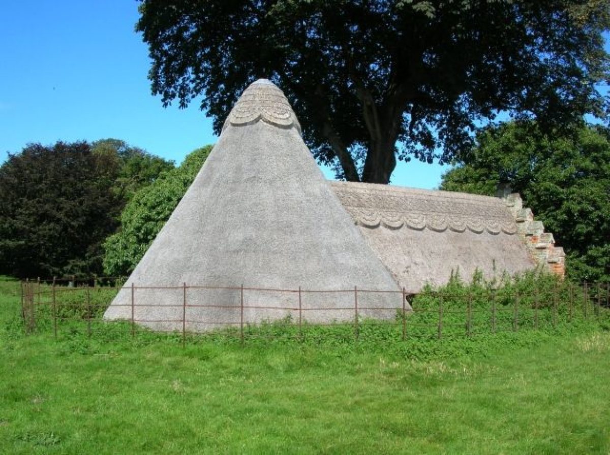
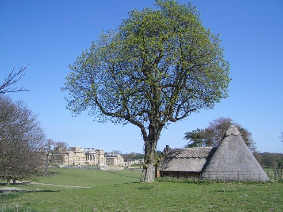
The accession of Thomas William Coke in 1776 saw the start of a further period of radical change. The park was massively expanded, mainly to the south, and Kent's south lodge demolished. The head gardener John Sandys began a major tree-planting campaign which surrounded the new and much larger park with continuous belts and established a number of large clumps within it. Numerous new lodges were built, to designs by Samual Wyatt. By 1800 the park extended to 1200ha but not all the land within the perimeter belts was under pasture. Most of the land added since 1776, to the south of Obelisk Wood, continued to be farmed as arable and it was in this area that Coke erected, in c 1790, the Great Barn. The Barn, again designed by Wyatt, was built as a venue for the 'sheep shearing', annual gatherings of farmers and landowners at which the ideas of the 'new husbandry' were propagated. Repton worked at Holkham in 1789 but his activities were restricted to the area around the lake and many of his Red Book proposals were never carried out.
There were only minor changes in the course of the C19. Between 1833 and 1839, a brick wall was constructed around the perimeter of the park and in 1843 Kent's north lodge was demolished to be replaced by a tall monument to Thomas William Coke, designed by Donthorne. In 1847 new south lodges designed by S S Teulon were built, and the following year a gothic screen, again by Teulon, was erected at the north gate which now became the main entrance to the Hall and park. More drastic changes came in 1849-54 when vast Italianate gardens, designed by William Andrews Nesfield and William Burn, were constructed around the Hall. Clumps of evergreen oaks were planted beside the central section of the main southern avenue. The C20 has seen few changes to this landscape. The site remains (1999) in private ownership.
Period
18th Century (1701 to 1800)
- Associated People
- Features & Designations
Designations
The National Heritage List for England: Register of Parks and Gardens
- Reference: GD1430
- Grade: I
Features
- Lake
- Walk
- Obelisk
- House (featured building)
- Description: The hall was built in a classical Palladian style between 1734 and 1764 by Thomas Coke, the Earl of Leicester. It is thought that the design of the building was much influenced by Coke's appreciation of classical art and architecture, developed during his Grand Tour in the early-18th century.
- Earliest Date:
- Latest Date:
- Stable Block
- Key Information
Type
Estate
Purpose
Recreational/sport
Principal Building
Domestic / Residential
Period
18th Century (1701 to 1800)
Survival
Extant
Hectares
1202
Open to the public
Yes
Civil Parish
Holkham
- References
References
- Carter, G. et al, {Humphry Repton Landscape Gardener 1752-1818} (Norwich: Sainsbury Centre for Visual Arts, 1982), p. 159 Humphry Repton landscape gardener 1752-1818
- {English Heritage Register of Parks and Gardens of Special Historic Interest}, (Swindon: English Heritage, 2008) [on CD-ROM] Historic England Register of Parks and Gardens of Special Historic Interest
- Stroud, D., {Capability Brown} (London: Faber, 1975), p. 229 Capability Brown
- Stroud, D., {Humphry Repton} (London: Country Life, 1962), pp. 36-8 Humphry Repton
- Pevsner, N., {The Buildings of England: North-west and South Norfolk} (Harmondsworth: Penguin, 1962), pp. 199-204 The Buildings of England: North-west and South Norfolk
- Popham, John {Holkham Heritage Management Plan} (1996) Holkham Heritage Management Plan
- Popham, John {Holkham Historic Landscape Management Plan} (1994) Holkham Historic Landscape Management Plan