Introduction
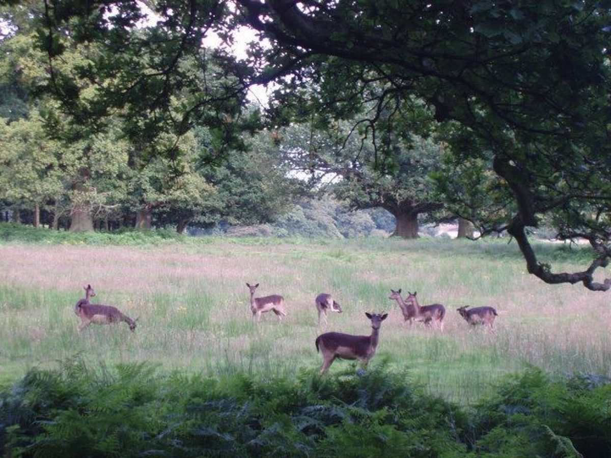
Melton Constable Hall had a medieval deer park, which was landscaped between 1764 and 1769 by Lancelot Brown. The park contains a temple and various follies, rhododendrons, firs and oaks. The landscape is now in divided use.
Terrain
The ground is gently undulating with an overall fall south to the lake.www.historicengland.org.uk/listing/the-list
A mid C19 formal terraced garden and C17 walled garden, set within a park of medieval origins landscaped in the mid C18 by Lancelot Brown.
DESCRIPTION
LOCATION, AREA, BOUNDARIES, LANDFORM, SETTING
Melton Constable Hall lies in rural Norfolk, along the east side of the B1110 Guist to Holt road, c 10km south-west of the market town of Holt. The park covers c 180ha, of which c 6ha are gardens and pleasure grounds. The west boundary is formed by the public road and a park wall which runs along its entire length. The wall extends around the north boundary beyond which lies farmland and the B1354. The south and east boundaries are fenced, with the thick plantation known as Wood Severals beyond to the south and farmland to the east. The ground is gently undulating with an overall fall south to the lake, leaving the Hall in a slightly elevated position in the centre of the park. The perimeter woods prevent views into or out of the park while internally there are good views between the Hall and the lake to the south. Well outside the northern boundary (but identified here as an outlier of the registered area), c 1.5km north of the Hall, is a late C18 circular five-storey watchtower.
ENTRANCES AND APPROACHES
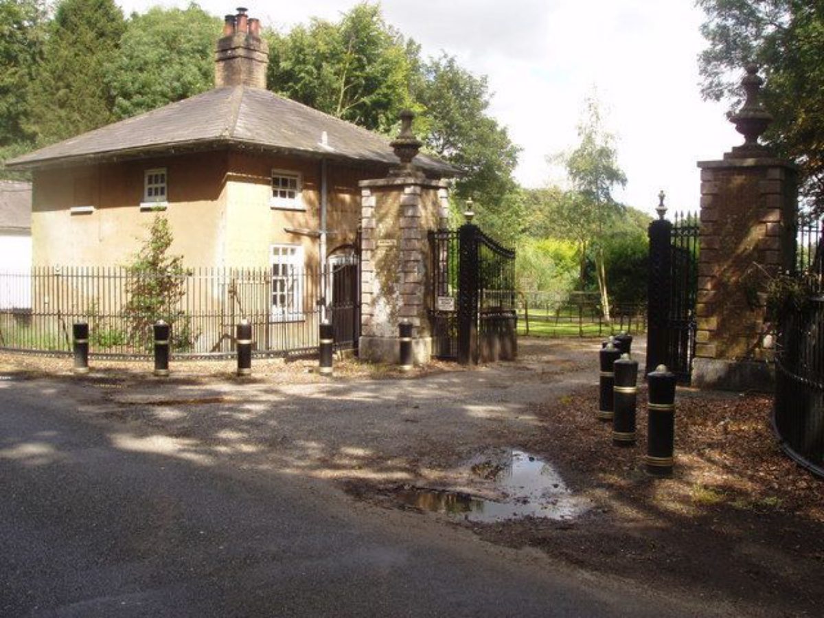
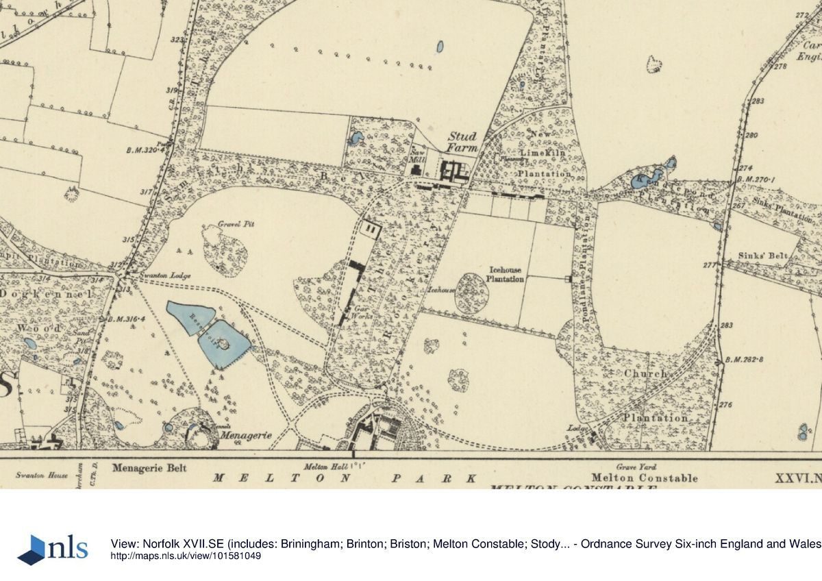
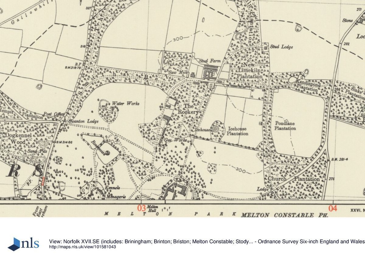
There are four lodged entrances to Melton Constable park which lie on the C18 boundaries of the park. To the north-west, c 700m from the Hall, the main drive enters off the B1110 through cast-iron carriage gates and curved railings (c 1810, listed grade II), past the stuccoed brick and slate early C19 Swanton Gate Lodge (listed grade II). The drive runs south-east to arrive at the north front and continues through an archway in the north wing to the service courtyard. The twin flint and brick North or Stud Lodges stand c 900m to the north-east, the drive entering the park a further 300m to the north, running south along Limekiln Plantation, through Stud or Park Farm and past another set of gates into the open part of the park. It continues south to meet the west drive north of the Hall. From the east the entrance is marked c 600m from the Hall by a set of carriage gates (listed grade II) and Church Lodge (c 1810, listed grade II), both gates and Lodge being in the same style as the Swanton entrance. The drive runs west to meet the west and north drives north of the Hall. In the south-west corner of the park, c 1.8km from the Hall, stand the Jubilee or Dereham Gates which mark a drive that runs first east and then north, through Wood Severals to the South Lodge c 1km from the Hall. Both the gates and the lodge were built in the early C20. The drive runs north through the park past the west front gardens and then turns east to the north front. The drive appears on the Tithe map of 1841 and is therefore older than the Lodge.
PRINCIPAL BUILDING
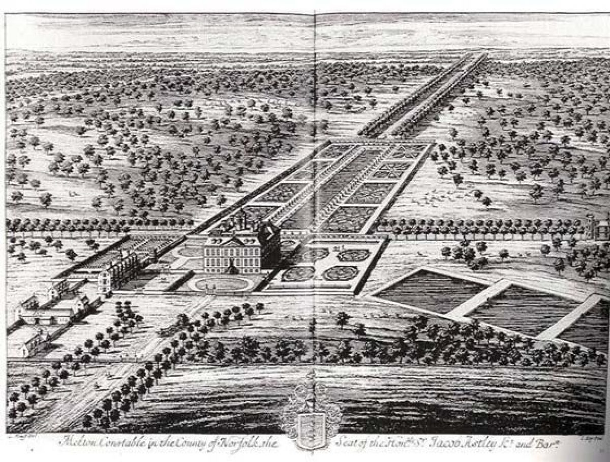
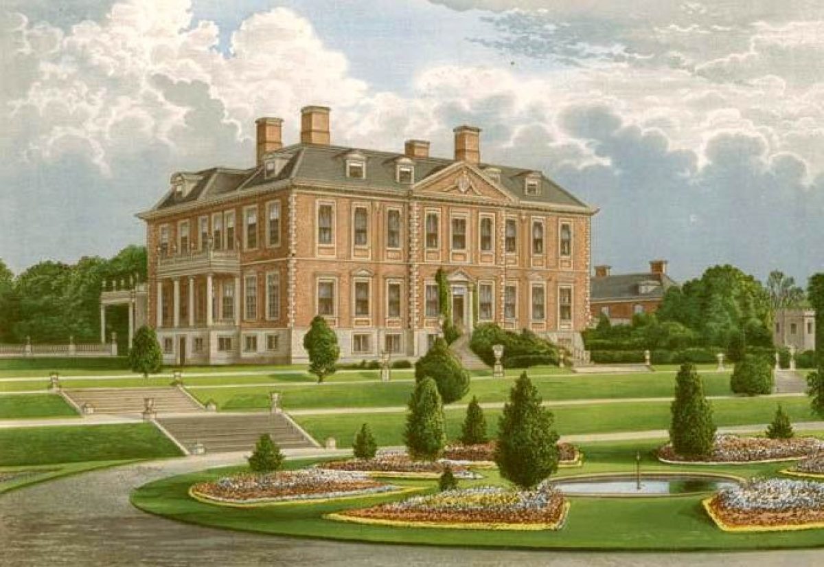
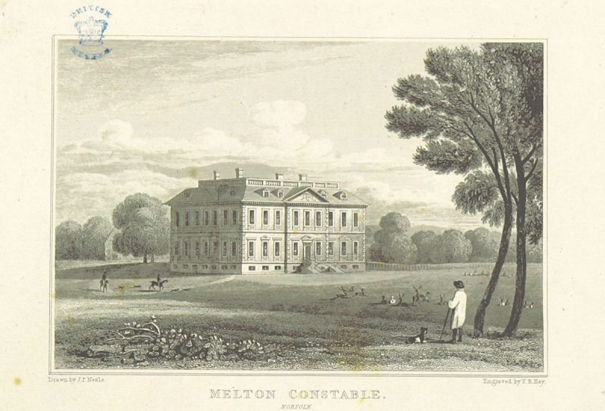
Melton Constable Hall (listed grade I) is a partly derelict (1999), partly restored large C17 country house built of red brick, stone, stucco wood, and lead dressings under slate and copper roofs in the domestic Classical style, sitting to the north of centre of a large park. It is built in a double-pile plan with extensions to the east and north. The north, entrance front has nine bays with a central raised doorway and richly cut wooden modillion eaves. The south, garden front is also of nine bays but with stone perron stairs and wrought-iron railings to a central mid C18 doorway. The west front has two outer bays and three central bays with an Ionic portico overlooking part of the formal terraced gardens and the Bath House in the park beyond. The east front has three central ground-floor bays brought forward as a bow. The Hall was built by Sir Jacob Astley between the late 1670s and 1687 to replace the house of c 1500. No architect for the design was recorded. The west front portico was added in 1757 and the Hall enlarged to the east in c 1800 to connect it to the service and stable wings. The north wing and part of the south-west wing of the stable courtyard (listed grade II*) form this connection, the wing of the Hall encasing a service range illustrated by Kip and Knyff in 1707. The stable courtyard ranges (listed grade II) are single-storey buildings constructed in a mix of red and gault brick under slated and copper roofs. The seven-bay west wing contains the entrance arch from the north front courtyard and is topped by a cupola with two clocks and two sundials, an arched bellcote, and copper roof with weathervane. The service ranges were added in c 1810 although the north and east walls of the north range may have been reused from a barn visible here in Kip and Knyff's engraving of 1707.
GARDENS AND PLEASURE GROUNDS
The gardens lie to the west and south of the Hall and are surrounded by a raised balustraded terrace (listed grade II) with open parkland beyond. They are a somewhat simplified version of the mid C19 layout with little planting other than the yew hedges surviving over the years of neglect. The West Garden, now described as the Croquet Lawn, has a central sunken lawn surrounded by yew hedges reached from an upper gravel terrace. To the south steps lead down from the gravel terrace through two levels of grass to the main sunken garden with the remains of three fountain basins. From here a further set of steps returns up to the raised terrace along the outer balustrade. The double yew-hedged bowling green lies to the east of the main lawn and beyond it to the east is the pleasure ground, studded with specimen trees and shrubs. The hard landscaping and decorative stonework remain largely intact from the c 1850 garden but are in poor condition (1999).
PARK
The large open park is scattered with areas of woodland and large tree clumps, almost entirely enclosed by boundary plantations. There are few individual trees and none of a great age, and the predominant species is oak. In the boundary woods and around the lodges there is a greater variety of trees with more conifers and exotics. The central core, known as the Deer Park, is laid to pasture whilst much of the remainder is under the plough. The mid C17 Bath House lies c 300m to the west of the Hall, beside the C19 kennels. Used as a banqueting house in the C18, it is a square two-storey building with a six-sided, three-storey tower (listed grade II) and is built of stucco brick under a slate roof. It was ornamented in the 'Gothic style' by Lancelot Brown in the mid C18. It is however a building of much earlier origins, being clearly shown on the Kip and Knyff engraving of 1707 and the estate map of 1674 when it was used as a hunting lodge. Some 200m to the north of the Bath House lie two ponds, the remains of a series of four shown in the 1674 map and originally fishponds associated with the site of the c 1500 manor house. Substantial blocks of woodland lie to the north of the Hall with Park House located along the northern boundary, beyond the early C19 icehouse, in Icehouse Plantation. St Peter's church (listed grade I), 700m to the east of the Hall just beyond the eastern boundary, forms a visual element in the landscape scheme across the open park.
The south park falls gently away from the Hall to the large serpentine lake c 1km to the south and the remains of the C17 south avenue can just be traced in the surviving trees. The lake has a circular island with crenellated brick edging and the weatherboard and slate late C18 Tea House (listed grade II) stands on the west shore.
KITCHEN GARDEN
The walled kitchen garden lies immediately to the east of the Hall, beyond the stable courtyard. It comprises two compartments with brick walls, breached at the north end of the west wall. Remains of derelict mid C19 glass ranges survive on the south-facing north walls. The northern compartment is laid to grass, with fruit cages and herbaceous borders at the south end, with some fan-trained fruit on the walls. The southern compartment is quartered with gravel and box, the sections planted with fruit and vegetables. The walls are of mainly early C19 origin but replace a walled garden on the same site dating from the C16, part of the building on the west wall incorporating brickwork of this date.
REFERENCES
J Kip and L Knyff, Britannia Illustrata (1707)
M J Armstrong, History of Norfolk (1781)
Country Life, 18 (10 September 1905), pp 378-84; 64 (15 September 1928), pp 364-70; (22 September 1928), pp 402-9
N Pevsner, The Buildings of England: North-east Norfolk and Norwich (1962), p 197
Architectural History 7, (1964), pp 31, 76
B Jones, Follies & Grottoes (1974), p 362
D Stroud, Capability Brown (1975), p 112
The Field, (22 June 1986), pp 19-21
J Garden History 11, (1991), nos 1 and 2, pp 76-8
T Williamson, The archaeology of the landscape park, BAR Brit Ser 268 (1998), pp 240-2
Maps
Hayes and Storr, Estate map of Melton Constable Park, 1674, redrawn 1732 (Map 82, M3), (Norfolk Record Office)
W Faden, A new topographical map of the county of Norfolk, 1797 (Norfolk Record Office)
A Bryant, Map of the county of Norfolk, 1826 (Norfolk Record Office)
Tithe map for Melton Constable parish, 1841 (Norfolk Record Office)
OS 6" to 1 mile:
1st edition published 1891
1947 edition
OS 25" to 1 mile: 2nd edition published 1905
Illustrations
Edmund Prideaux, Sketch of Melton Constable Hall, 1725(7 (RCHM(E), London)
Engraving for the London Magazine, 1742 (Norfolk Record Office)
Humphry Repton, Sketches of Melton Constable (for Armstrong's History of Norfolk, 1781)
Description written: August 1999
Register Inspector: EMP
Edited: March 2001
- Visitor Access, Directions & Contacts
- History
The following is from the Register of Parks and Gardens of Special Historic Interest. For the most up-to-date Register entry, please visit the The National Heritage List for England (NHLE):
www.historicengland.org.uk/listing/the-list
HISTORIC DEVELOPMENT
The Astley family gained the manor of Melton Constable through marriage in 1236 and a park was enclosed here in 1290. A medieval manor house, probably on a moated site, stood just to the south-east of the present hall, the building of which was started by Sir Jacob Astley, first Lord Hastings in the late 1670s and completed around 1687. A map of the estate dated 1674 shows the Hall and garden enclosures surrounded by a park of c 50ha. Melton Constable is the only site in Norfolk to appear in Kip and Knyff's Britannia Illustrata in 1707 which shows that by this time a large and complex formal garden with avenues radiating out into the surrounding landscape had been developed. This layout survived until Sir Jacob's death in 1729 at the age of ninety. Within the next ten years however it was radically reworked to be replaced by a landscape of open grass with the Hall standing on a slight terrace. In 1764 Sir Edward Astley employed Lancelot Brown (1716-83) to improve the park, a commission which took him five years and included the creation of the lake, the planting of perimeter belts, and the embellishment of the Bath House in the 'Gothic' style. The Astleys continued to make changes to the landscape long after Brown's recorded activities here. The park was extended to the south and, following a Road Closure Order in 1784, to the north to set the Hall more centrally in the ornamental landscape. Humphry Repton (1752-1818) made a sketch of Melton Constable around this time for Armstrong's History of Norfolk (1781). Sir Jacob Henry Astley succeeded to the title in 1802. An extensive eastern range was also added to the Hall in the early years of the C19 century, west and east lodges were built, and an arboretum established in an oval surrounding the kitchen garden, stables, and offices. He was succeed in 1817 by his son, also Sir Jacob, an enthusiastic huntsman, who stayed at Melton until his death in 1859. Soon after the Tithe map was surveyed in 1841 an Italianate garden was laid out on the south and west fronts of the Hall and an icehouse, kennels, gasworks, and a ha-ha added to the park. Further alterations were made to the Hall between 1880 and 1920 during a period when the park was again slightly enlarged and the Jubilee or Dereham Gate constructed in the south-west corner. The formal gardens were maintained into the C20 but were grassed over when the estate left the hands of the Astley family between the wars, after 700 years of ownership. The site was purchased by the Duke of Westminster who sold it again in the 1950s to a Mr Harrold whose interests were mainly agricultural. Most of the park was ploughed and the Hall left to decay. In 1985 the threat of a compulsory purchase order forced the owner to sell the Hall and parts of the estate. It remains (1999) in divided private ownership.
- Associated People
- Features & Designations
Designations
The National Heritage List for England: Register of Parks and Gardens
- Reference: GD1515
- Grade: II*
Features
- Temple
- Folly
- Hall (featured building)
- Earliest Date:
- Latest Date:
- Gate Lodge
- Kitchen Garden
- Stable Block
- Icehouse
- Kennels
- Ha-ha
- Key Information
Type
Park
Purpose
Ornamental
Principal Building
Domestic / Residential
Survival
Extant
Hectares
180
Open to the public
Yes
Civil Parish
Melton Constable
- References
References
- {English Heritage Register of Parks and Gardens of Special Historic Interest}, (Swindon: English Heritage, 2008) [on CD-ROM] Historic England Register of Parks and Gardens of Special Historic Interest
- Stroud, D., {Capability Brown} (London: Faber, 1975), p. 112 Capability Brown