Introduction
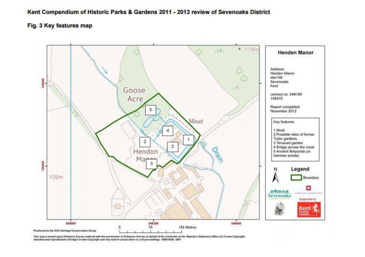
The main areas of the garden lie to the south-west, west and north-west of the Manor house. They are defined by three-metre high formal hedging, topiary, expansive lawns and rising terraces, situated both within and beyond the main focal point of the garden: the moat. The moat, certainly Tudor and probably earlier, encompasses the Manor house on its north-west, north-east, and south-east sides and is bordered by sloping grass banks planted with aquatics such as gunnera and water iris. Along the south-west front of house, the walls of which are clothed with wisteria, the flagstone path forms a terrace. Immediately to the north-west of the house, and also within the moat, lie two compartmentalised gardens intersected, on a north-west to south-east axis, by clipped leylandii hedging.
Terrain
The garden is situated on low, partly-sloping ground below the southern slope of the Greensand Ridge, amid expansive areas of the estate's undulating and sloping farmland and woodland.STATEMENTS OF SIGNIFICANCE
Henden Manor is to be included on the local list of heritage assets for the following principal reasons:
The site exhibits surviving features of C16, or earlier, and early C20 garden design, the main structure of the garden within and immediately beyond the moat remaining intact and unaltered from the C16; the whole provides a contemporary garden setting to the grade II listed, moated Manor house.
From the C13 to C16, important historical associations include ownership of the estate by the Despencer and Burghersh families, the Earls of Warwick, Henry VIII, Thomas (father of Ann Bulleyn) and John Gresham who acquired the estate through services to Henry VIII.
Documentary evidence, and initial field evidence from surviving terracing, indicate that individual Tudor gardens probably existed both within and immediately beyond the moat, with capacity for re-creation. There is archaeological potential for discovering more about the existence of Tudor gardens.
A significant surviving feature from the C16, or earlier, is the moat, which has been fully restored and forms an important focal point for the garden. There are also two fishponds, probably medieval and possibly serving later as hammer ponds.
The current boundaries of the wider Henden Manor estate, and the landscape features within it have, like the garden, remained largely unchanged since the C16.
Notable political and artistic associations in the C20 include ownership by Viscount Hudson, Minister for Agriculture in the Churchill Government, and a tenancy by the film producer, Michael Balcon.
The history of Henden Manor, particularly during the C16, is well-supported by primary evidence including, critically, the existence in 1590 of 10 Tudor gardens, which were extant some 200 years later and are almost certainly those illustrated on an early C19 map.
SITE DESCRIPTION
LOCATION, AREA, BOUNDARIES, LANDFORM, SETTING
Henden Manor lies 1.8km south of the village of Ide Hill, in the parish of Sundridge with Ide Hill, to the west of the Ide Hill Road (B2042). Sundridge is situated 5.8km to the north, Edenbridge 7.4km to the south-west, and Sevenoaks 9.8km to the east.
The garden is situated on low, partly-sloping ground below the southern slope of the Greensand Ridge, amid expansive areas of the estate's undulating and sloping farmland and woodland. It is bordered to the south by clipped cypress hedging running parallel to the tarmac approach road (a public right of way). To the west, it is bordered by laurel hedging, running parallel to a footpath heading in a north-westerly direction towards Ide Hill: to the north, by more hedging running adjacent to the C20 kitchen garden, immediately beyond which lies a field known historically as both as the Drove and the Grove; and to the north-west by post and rail fencing enclosing light woodland and pleasure gardens. The eastern boundary is formed by hedging running parallel to a field, formerly divided in two and known as The Five Acres and Tanners Mead (1809 estate map and apportionment).
The 3ha garden is set within the wider c200ha Henden Manor estate which lies largely within the parish of Sundridge, but straddles Brasted parish to the west, and Chiddingstone parish to the south. The estate is bordered to the north by Ide Hill, to the east and south by Ide Hill Road (B2042), and to the north-west and west by farmland and woodland.
Henden Manor is approached by two tarmac drives, with open entrances, to the south and the north east boundaries of the estate. The main entrance to the estate, on the south side, is approached from the northern side of Ide Hill Road, the B2042, and the drive runs in a north-easterly direction for c1km through woodland and farmland before reaching the main farm buildings, twin C18 oast houses (listed grade II) and a bridge across the moat which forms the main entrance to the Manor house.
The second entrance to the estate, on the north-east boundary, is approached from the east side of the B2042. The drive descends in a south-westerly direction for c650 metres through farmland, passing the stone-built Keeper's Cottage (in separate private ownership) to the north, and, beyond the cottage, a five-bar wooden gate, before reaching the bridge to the Manor house. Evidence suggests that this was the main entrance to the estate from at least the late C18 (Andrews, Drury and Herbert map of 1769).
Cumulative evidence shows that the historic boundary of the estate has remained largely unchanged from the late C16 until now (2012) (estate maps, conveyances and 1st- 4th OS maps).
ENTRANCES AND APPROACHES
The main north-east facing entrance to the Manor house is approached across the moat via a stone-arched, C19 bridge (listed grade II). The bridge is situated c30m south-east of the house and leads to a gravelled forecourt. The main areas of the garden are reached via a York stone pathway which runs in a south-westerly direction for c13m parallel to the south-east elevation of the house.
A second entrance to the garden, via double wooden gates set into the boundary hedge, lies 40 metres south of the Manor house, immediately beyond the moat. A third entrance, also with double wooden gates set into the boundary hedge, lies c170 metres west of the Manor house and provides direct access to the orchard and kitchen garden.
PRINCIPAL BUILDING
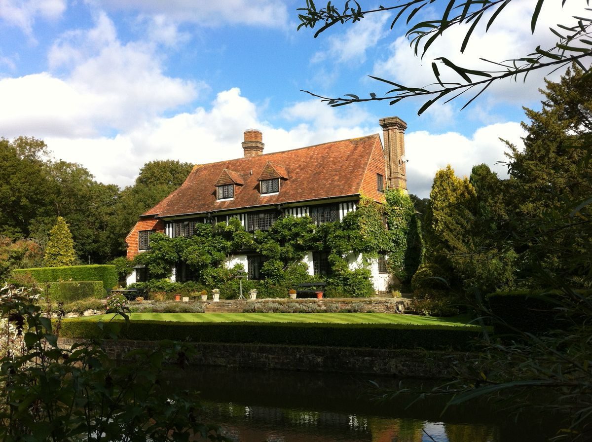
Henden Manor House (listed grade II) is a C16, or earlier, moated farmhouse which has been much extended, altered and restored. The main garden front is 3 window bays wide, 2 storeys high with an attic storey. It has a high pitched tiled roof with plastered, coved eaves soffit, and two C20 gabled dormers. The exposed timber framing is believed to have been restored with plaster filling. There are modern leaded casements of many lights. The entrance front shows a C19 gable ended right wing, part brick, part tile hung; and a modern extension, containing a corner entrance. The interior has exposed beams and late C16 wainscoting in 2 rooms. The wainscoting above the dining room inglenook has panels carved with initials and the date 1577. There are two Tudor-type stone fireplaces, the small upstairs one with carved spandrels (listed buildings description).
GARDENS AND PLEASURE GROUNDS
The main areas of the garden lie to the south-west, west and north-west of the Manor house. They are defined by three-metre high formal hedging, topiary, expansive lawns and rising terraces, situated both within and beyond the main focal point of the garden: the moat.
The moat, certainly Tudor and probably earlier, encompasses the Manor house on its north-west, north-east, and south-east sides and is bordered by sloping grass banks planted with aquatics such as gunnera and water iris. On the south-west side, a rectangular pond, fed by a rill running in a south-easterly direction, flows over a waterfall into the moat. This pond is, in effect, the fourth side of the moat.
The garden to the south-west of the house, and within the moat, is approached from the north-east of the Manor house via a c2.5metre wide York flagstone path, bordered to the east by mixed conifers and a narrow area of light woodland, including a yew tree of indeterminate age, but at least 200 years old.
Along the south-west front of house, the walls of which are clothed with wisteria, the flagstone path forms a terrace. Flights of steps lie at the centre and at the eastern end of the terrace, which descend southwards to a rectangular expanse of lawn, c30m x 14m. A lavender and geranium border lies north of the lawn, and to the west an herbaceous border. West of the herbaceous border, and running parallel to it, is a flagstone path and, immediately beyond the path, a clipped hedge of mixed beech and field maple, extant in 1937 (photographic evidence from 1937 sales particulars). To the south, the lawn is bordered by a hedge of clipped box, immediately beyond which lies a stone retaining wall for the rectangular pond below. Evidence shows that this area of lawn was the site of a late C18/early C19, and probably earlier, garden (1809 estate map and apportionment).
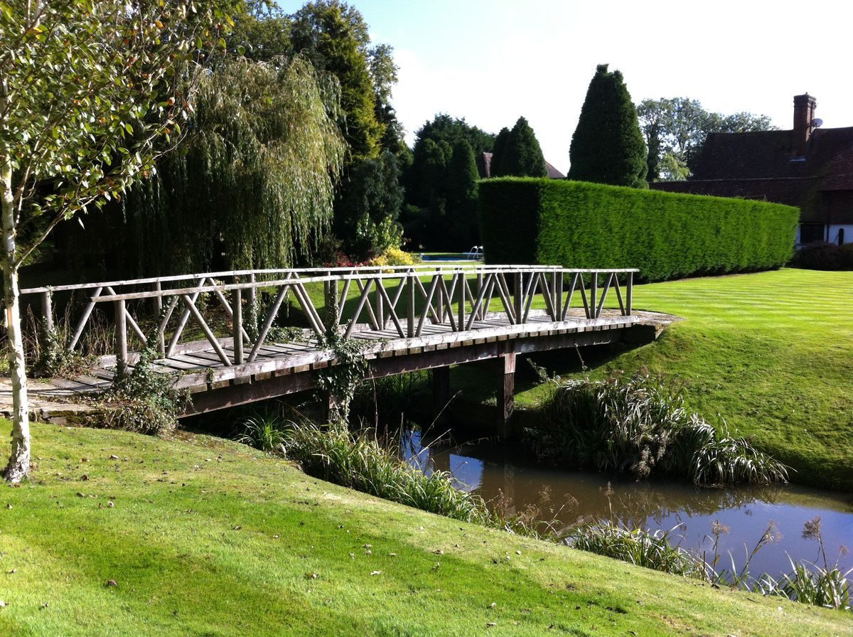
Immediately to the north-west of the house, and also within the moat, lie two compartmentalised gardens intersected, on a north-west to south-east axis, by clipped leylandii hedging. The garden to the south (c32m x 28m) is mainly laid to lawn, studded with specimen trees including a copper beech. It is bordered to the south-west by the rill feeding the rectangular pond and to the north-west by the moat. On the north-west border, a rustic wooden bridge (a prominent feature of the garden) spans the moat, leading to an area of light woodland known as Goose Acre. The garden to the north, mainly laid to lawn, (c32m x 22m) accommodates a kidney-shaped swimming pool and a wooden pool-house. It is enclosed by leylandii hedging and a belt of conifers on the south-west side, and on the north-west side by an island bed of mixed conifers situated close to the moat. To the south-east of the swimming pool area, a gravel path runs for c43 metres in a south-westerly direction between several C20 brick outbuildings and the north-west elevation of the Manor house. It then widens into a gravel platform which forms both a bridge over the rill where it meets the pond (replacing an earlier C20 rustic bridge) and an axial route to the remaining areas of the garden, outside the moat.
From this central axis, a gravel path runs for c32 metres in a south-easterly direction, bordered by herbaceous beds and clipped shrubbery, including lavender, abelia and euonymus. The path then turns in a south-westerly direction, terminating almost immediately by double wooden entrance gates set into the boundary hedge. Immediately beyond the central axis to the south-west, a gently-sloping path ascends for 45 metres, and is terminated by a clipped yew hedge running east to west, with columnar topiary flanking a central gap in the hedge. The path forms an intersection between sloping lawns to the east and three rising lawn terraces to the west. Two flights of steps, built of York stone and red brick, extant since the early C20, are set along the path and serve as links between the terraces. On each side of the steps, and at an intermediary point along the path, stand mature bowl-shaped topiary, formed from the fastigiate yews planted in the early C20.
To the north-west of the central axis, a narrow flagstone path runs for c40 metres alongside the rill and provides access to the lower terrace (c68m x 7m), which is mainly laid to lawn, with shrubbery to the west. Documentary evidence indicates that this terrace was the site of several compartmentalised gardens, first recorded on the 1809 estate map, which possibly formed part of the ten C16 Tudor gardens.
The second terrace (c70m x 17m) is also mainly laid to lawn, intersected to the west by mixed conifers and with specimen trees beyond. It is separated from the upper terrace by a further belt of mixed conifers and a horse-shoe shaped enclosure, formed by a 3m high, formal yew hedge. This enclosure, probably a remnant of the Italianate garden, overlooks the lower terraces, and is approached by an ascending flight of five worn York-stone and red-brick steps leading to a stone platform encompassed by the hedge. A wooden summerhouse stands in the north-west corner of the terrace, c17 metres north-west of the enclosure, and c70 metres north-west of the Manor house.
The upper terrace (c62m x c22m) is also mainly laid to lawn, and bordered to the south-west by the yew hedge which marks the end of the path. Photographic evidence shows that, in 1937, the formal garden was in its infancy, and more distinctly terraced than it is now (2012), reflecting an Italianate style, with rectangular rose beds on each side of the upper terrace. These rose beds no longer remain, but have been replaced by two small circular beds, one on each side. Otherwise, the structure of the formal garden has remained largely unaltered throughout the C20 and C21.
Beyond the formal garden, a gap in the yew hedge leads to an area of lawn c60m x c30m, studded with specimen trees and shrubs, including cedar, ash and laurel. This area of lawn, and the entire terraced garden, is bordered to the north-west by a 3m high, formal yew hedge.
Approximately 125 metres north-west of the Manor house, a stream emanating from the northern slopes of Ide Hill, flows in a south-easterly direction for c56 metres into a square, brick-lined water tank. This tank forms a sluice to the rill that runs from north-west to south-east through to the rectangular pond and the moat. At intervals along their length, the rill and the stream are spanned by bridges formed by wooden sleepers, which provide access to a c0.5ha area of light woodland immediately to the east.
The woodland lies c60 metres north, north-west of the Manor house and is planted mainly with field maple and common oak. Within the woodland are two ancient fishponds, probably medieval: they are also known as hammer ponds, reflecting their possible use as a water source for an early iron forge (pers.comm.). Although described in the early 1980s as ‘two well-preserved rectangular fishponds, one dry, the other marshy' (KCC HER) they are now (2012) full and merge into each other. A stream flows from the eastern edge of the ponds, in a south-easterly direction, to feed the moat. To the north-east and adjacent to the ponds stands a wooden summer house, accessed by a woodland path. Approximately thirty metres north of the ponds, post and rail fencing forms a boundary between the light woodland area and the dense c1.0ha woodland of Goose Acre.
KITCHEN GARDEN
The 0.67ha, C20 kitchen garden lies on sloping lawns on the western and north-western perimeter of the garden, c140m to the west of the Manor house, with commanding views north, towards Ide Hill. It is intersected by a central pathway which runs on a south-west to north-east axis from the boundary hedge. To the south-east of the path, lies a 0.2ha orchard planted with serried rows of apple trees, adjacent to two lateC20/earlyC21 aluminium-framed green houses and a wooden potting shed,. To the north-west of the path, lie vegetable and flower beds, a smaller area of fruit trees, and a series of fruit cages (constructed in the late C20) supported by wooden pergolas running parallel to the perimeter. Beyond the kitchen garden and orchard to the north-east, stands a hard tennis court (first recorded on the 1936 6" OS map), fully refurbished in the late C20, and enclosed on three sides by clipped leylandii hedging. The 1937 sales particulars list "an excellent hard tennis court, well stocked kitchen garden with heated span glass house and heated pits, and iron-roofed tool and potting sheds". The span glass house and the iron-roofed sheds, however, no longer remain.
Detailed description contributed by Kent Gardens Trust 27/04/2016
REFERENCES
Books and articles
E. Hasted, The History and Topographical Survey of the County of Kent: Volume III (1797-1801)
Sundridge Parish Council, Sundridge - A Brief History (1994)
C. Sherwen (editor), Barrow Green Court: Barrow Green House: a gentry house (Brompton Press, 2004)
Ide Hill Society, Ide Hill Past and Present (2010)
Maps
Map of Hethenden Farm, ‘John Lamberd's Farm', showing field boundaries, parchment 10" x 6", late C17 (Surrey History Centre ref. K87/17/53)
Map of Heathenden, John Lamberd's Farm, late C17 (Surrey History Centre ref. K87/19/9)
J. Andrews, A. Drury & W. Herbert, A Topographical Map of the County of Kent in Twenty Five Sheets 1769 (Kent History and Library Centre)
W. Mudge, An Entirely New and Accurate Survey of the County of Kent 1801 (Kent History and Library Centre)
Estate map and apportionment: Heathenden Farm situated in the several parishes of Sundrish, Brasted and Chiddingstone in the County of Kent, 1809 (Surrey History Centre ref. 7658/2/1)
Sundridge Tithe Map and apportionment 1841 (Kent History and Library Centre ref. CTR357B)
Ordnance Survey map: 25" to 1 mile1st edition (1862-75)2nd edition (1897-1900)3rd edition (1907-1923)4th edition (1929- 1952)
Ordnance Survey map: 6" to 1 mile1910 edition1936/7 edition
Illustrations
Photographs from the Henden Manor estate sales particulars, June 1937, Messrs. Wilson & Co. (private document)
Site survey photographs (2012)
Archival items
Lease between Thomas Bulleyn, Earl of Wiltshire and Ormond, and Robert Cranwell, 24th March 1537 (Surrey History Centre ref. K87/17/8)
Title deeds for various properties, including Henden Manor, 4th July 1541 (Kent History and Library Centre ref. U1450/T5/62)
Conveyance between William Gresham and Charles Hoskins, 18th July 1590 (Surrey History Centre ref. K87/17/20)
Proceedings between Charles Hoskins and William Gresham relating to Henden Manor, October 6th 1590 (Surrey History Centre ref. K87/17/23)
Conveyance, Charles H. Master and Barrow Green Estate, Oxted, 2nd October 1926 (Surrey History Centre ref. 7658/2/2-3)
Henden Manor Estate, sales particulars, June 1937, Messrs. Wilson & Co. (private document)
Survey and report on the condition of Henden Manor Farm, G.V. Philcox, 26th July 1940 (Museum of English Rural Life, Reading ref. KEN10/1/1)
Kent County Council, Historic Environment Record, Henden Manor House, the latest source record listed, dated 1979
Henden Manor Estate, sales particulars, October 1992, Knight Frank and Rutley International, and Savills International (Sevenoaks Library ref. B459)
Henden Manor Land Registry title deed, K448807
- Visitor Access, Directions & Contacts
Website
https://www.hendenmanor.com/en/Access contact details
Henden Manor is a private estate.
- History
SUMMARY OF THE HISTORIC INTEREST
A water, woodland and formal terraced garden, laid out in and around a surviving C16, or earlier, moat surrounding a C16 Manor house: the gardens developed from the site of a compartmentalised, probably Tudor, layout, recorded as extant into the early C19, and from a subsequent early C20 Italianate terrace garden. The manor has associations with nationally-important figures including, during the C16, Henry VIII, Sir Thomas Bulleyn (or Boleyn), Sir John Gresham and, in the early C20, Viscount Hudson.
CHRONOLOGY OF THE HISTORIC DEVELOPMENT
Henden Manor lies in the village of Ide Hill, known as Edythshill before the Norman Conquest, within the ancient parish of Sundridge, known variously as Sondresse (Domesday survey of 1086), Sundrish or Sundrych (early deeds and maps). Between the reigns of Henry III (1216-72) and Henry VIII (1509-47), a manorial court was held at Henden, and the Manor, together with its estate, was gifted by royal consent to high-ranking families for services to the Crown. During this period, it passed variously through the families de Burghersh, le Despencer and the earls of Warwick (Hasted).
In c1517, Henry VIII exchanged Henden Manor and its associated land, including a deer park known as Henden Park, with Sir Thomas Bulleyn (or Boleyn) for Newhall Manor in Essex (Hasted). His daughter, Anne Bulleyn, later became Queen through her marriage to Henry VIII. In 1537, Sir Thomas Bulleyn, now the Earl of Wiltshire and Ormond, leased the manor to Robert Cranwell (lease 24th March 1537). On the Earl's death in 1539, ownership passed to William Stafford through his marriage to Mary Bulleyn. In 1541, Stafford was forced by Henry VIII to exchange ownership of the manor for land in Yorkshire (title deeds 4th July 1541). In 1543, Henry VIII bequeathed the Henden estate to Sir John Gresham for his services to the Crown, and, according to Hasted, Henden Park was disparked shortly before Gresham's death in 1556. When Sundridge parish records began in 1562, the Henden estate was recorded as the larger of two substantial farms in Ide Hill, with a ‘sizeable' population (Ide Hill Society).
The estate remained in the Gresham family until 1590, towards the end of Queen Elizabeth's reign, when it was sold in its entirety to Charles Hoskins of Barrow Green Estate, Oxted, Surrey (conveyance 18th July 1590). Although the sale was disputed, it was enforced in a judgement later that year. The description of the property and associated land mentions ‘10 messuages, including a dove house, 10 gardens, 10 orchards, 400 acres of land, 500 acres of pasture, 120 acres of woodland' (details of fine, October 6th, 1590).
Henden Manor then remained in the Hoskins family for over 200 years, and for most of this time it was tenanted as a farm, variously described as ‘Hethenden' or ‘Heathenden' farm. Evidence shows that, in 1790, the land associated with the Manor remained intact, including the 10 orchards and 10 gardens first cited in 1590 (recovery of default judgement, 1790).
On the deaths of Susannah Chicheley Gorges (née Hoskins) in 1798, and of her husband in 1806, the Hoskins inheritance passed to her aunt, Katharine, widow of the Reverend Legh Master of Newhall, Lancashire, and thereafter descending to the Hoskins-Master family (Sherwen). In 1926, Henden Manor, together with the Barrow Green estate, was sold to the Barrow Green Estate Company by Charles Hoskins Master (conveyance, 2nd October 1926). In 1933, Henden Manor was leased for five years to the well-known Ealing Studios film producer, Sir Michael Balcon (1896-1977).
Evidence shows that between 1910 and 1937 the gardens were expanded to the south-west and west, and kitchen gardens and a tennis court created to the north-west of the house (1910 and 1936/7 OS 6" maps), in the area of the estate formerly known as Barn Field (1809 estate map and apportionment). This evidence also indicates that between 1910 and 1937 the area of the moat had dried up to the north-west and in part to the north-east.
In 1937, the Henden Manor estate was again put up for sale by Robert Spear Hudson, MP, later Viscount Hudson (1886-1957), Minister for Agriculture in the Churchill Government, and in 1939 it was sold to Geoffrey Vincent Philcox (land registry title deeds). According to Philcox, at the time of purchase, the farm was in a ‘derelict condition' (Philcox), but photographic and documentary evidence from the 1937 sales particulars shows that this description did not apply to the Italianate terrace and the pleasure grounds which formed part the expansion of the garden between 1910 and 1937. During the Second World War, it is understood that the Italianate garden was dug up and replaced with a ‘Home Garden' for food production to assist the war effort (pers comm.).Since the War, the Henden Manor estate has passed through several owners, including a Mr Ron Scott who, in 1978, fully restored the moat (pers.comm.). In 1992, when the estate was put up for sale again, the sales particulars of 1992 notably record the gardens and pleasure grounds in very similar terms to the 1937 description.
The present owners purchased Henden Manor in 1997, and it remains in single private ownership.
Detailed history contributed by Kent Gardens Trust 27/04/2016
Period
- Post Medieval (1540 to 1901)
- Tudor (1485-1603)
- Features & Designations
Style
Formal
Features
- Manor House (featured building)
- Description: Henden Manor House (listed grade II) is a C16, or earlier, moated farmhouse which has been much extended, altered and restored. The main garden front is 3 window bays wide, 2 storeys high with an attic storey. It has a high pitched tiled roof with plastered, coved eaves soffit, and two C20 gabled dormers.
- Latest Date:
- Key Information
Type
Garden
Purpose
Ornamental
Principal Building
Domestic / Residential
Period
Post Medieval (1540 to 1901)
Survival
Extant
Hectares
3
Civil Parish
Sundridge with
- References
References
Contributors
Beverley and Paul Howarth
Kent Gardens Trust