Introduction
Chartwell has gardens and landscape of 31 hectares associated with the principal building, which was the home of Sir Winston Churchill from 1924 until his death in 1965. The gardens in their current form were designed by Churchill and reflect his interest in landscape and nature. The garden contains many separate areas including terraced hillside gardens, Lady Churchill's rose garden, the 'Golden Rose Avenue' and a kitchen garden.
Terrain
The site occupies the steep east and west slopes at the head of an enclosed valley which opens southwards to give extensive, long-distance views over the Kentish Weald and to the plain of the River Eden beyond.This is outstanding scenic country. The great sandstone ridge, richly wooded and steeply sloping, provides wonderful views over largely unspoilt countryside in the Toys Hill and Crockham Hill areas.
The gardens are terraced and sectioned using brick or stone walling, leading down from the house to the lakes. In general the terraces are grassed with herbaceous borders and climbing plants on the walls. At the top is a croquet lawn with a small pavilion under a large copper beech. This site was a tennis court up to World War 2. Nearby are stones commemorating Sir Winston's poodles and cat.
Further down the slope is the Marlborough Pavilion on the corner of a lawn. It is decorated with scenes from the Battle of Blenheim of which Sir Winston's ancestor the Duke of Marlborough was the victor. The work was carried out by Sir Winston's nephew, John Churchill, as a birthday gift from Lady Churchill. A pergola with climbing roses and vines leads up to the Pavilion.
Sir Winston's painting studio is in the orchard, and the associated memorabilia - easel, unfinished canvasses and so on - are on public view. Sir Winston and Lady Churchill lived in the adjoining cottages, converted from stables, for short periods at the beginning of the war.
Near the top of the gardens is an informal rock pool area with massed planting of hostas, acers and bamboos. The bottom lakes support many waterfowl, including the famous black swans of which Sir Winston was very proud. These were originally a gift from Australia.
The woodlands on the hills around the house were extremely badly damaged by the 1987 storm. Many of the large beeches, oaks, conifers, cedars, cryptomerias, limes and other trees have been felled, and great tracks of woodland completely flattened on the hillsides.
The car park area is screened and landscaped with massed shrubs, blending very well into the more natural landscape nearby.
The following is from the Register of Parks and Gardens of Special Historic Interest. For the most up-to-date Register entry, please visit the The National Heritage List for England (NHLE):
www.historicengland.org.uk/listing/the-list
An early to mid-20th-century garden, created by Sir Winston Churchill and his wife and later influenced by the garden designer, Lanning Roper, with a few surviving 19th-century features and surrounded by a park of 18th-century origin.
DESCRIPTION
LOCATION, AREA, BOUNDARIES, LANDFORM, SETTING
Chartwell lies c 0.5km to the east of the B2026, 2.5km south-south-west of the village of Westerham. The registered site, comprising 8ha of formal and ornamental gardens and c 23ha of parkland, occupies the steep east and west slopes at the head of an enclosed valley which opens southwards to give extensive, long-distance views over the Kentish Weald and to the plain of the River Eden beyond. The site is enclosed to the west, north-east, and south-east by wooded ridges, with a minor lane marking the boundary along the north-east side. To the north-west, a fenced narrow tree belt and a public footpath separate the site from the rising, wooded farmland beyond, while to the south, a track serving Chartwell Farm forms the boundary. The site is crossed from north to south by Mapleton Road which passes c 15m from the west front of the house.
ENTRANCES AND APPROACHES
The main formal approach to Chartwell is from Mapleton Road, which also forms the western boundary of the house and gardens. The short length of gravelled drive up to the principal, west front of the house enters and exits through oak-boarded gates and frames an open, semicircular lawn, enclosed from the road by a high brick wall (listed grade II), built in the early 1920s to a design based on one at Quebec House (General Wolfe's birthplace at Westerham). The house was approached in the C19 by a single drive which followed the route of the present southern arm. A low hedge encloses a forecourt along the front of the house, designed, together with the lawn, in the early 1920s to replace the former Victorian shrubberies, from which the two mature lime trees survive. The present public entrance to the site is at the extreme north end, 200m down a serpentine drive and through the car park.
PRINCIPAL BUILDING
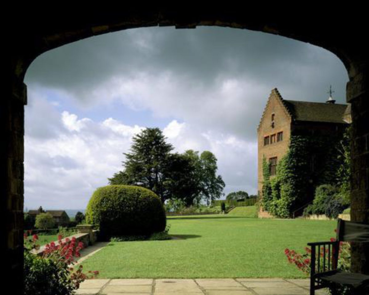
Chartwell (listed grade I) lies towards the south-west corner of the site, on the upper slope of the west side of the valley and with the principal rooms looking south and south-eastwards over the lakes and the distant landscape. It is built of red brick with a high, pitched roof and a two-storey entrance front in an 'undecided style' (Newman 1969). Three buildings are shown on the site of the house in the mid C18 (Andrews and Dury, 1742). By 1836 the house was described in sale particulars as in a partial state of decay (Meehan 1988) and was largely rebuilt sometime after 1850, the principal front being created on the west side, away from the view. In 1922 Churchill engaged the architect Philip Tilden (1887-1956) to carry out radical alterations; these included adding the wing which extends eastwards at right angles from the house, the stepped gable on the south front, and the simplification of the west elevation with the imported C18 wooden doorcase framing the main entrance.
GARDENS AND PLEASURE GROUNDS
The formal and ornamental gardens lie to the north, east, and south of the house. From 1965 until 1980, and as part of the agreement for Chartwell being passed to the Trust, Lanning Roper (1912-83) became Gardens Advisor under the direction of Churchill's daughter, Mary Soames, and, largely between 1965 and 1968, had considerable influence on the present appearance of the gardens.
The east front of the house opens onto a broad terraced lawn, which extends to both north and south beyond the house and which is raised several metres above the level of the lawn below by a ragstone wall built in 1950 to replace a former grass bank. A flight of steps runs down against the east face of the terrace wall to the lower lawn. In the furthest north-east corner and built up from the terrace walls is the ragstone Marlborough Pavilion, built as a summerhouse by Philip Tilden in the 1920s and decorated in 1949 by Churchill's nephew, John Spencer Churchill. A wide flagged path leads westwards from the pavilion under a vine-covered timber pergola into the Rose Garden. This may also be reached from the north side of the house, across a small paved terrace raised above the main terrace lawn by a low wall topped by a bank of shrubs (constructed 1984) and by a flight of C19 semicircular stone steps (shown on the OS 1st edition, surveyed 1869, rebuilt early 1990s). The Rose Garden is enclosed on its entire west and north sides and on part of its east side by high ragstone walls. A walled enclosure in approximately the position of the present rose garden is shown on Andrews and Dury's map of 1742 but by 1869 (OS) only the present west wall seems to be shown as standing. In 1922 Tilden extended the walls northwards. The garden layout, originally planned for Clementine Churchill by Venetia Montagu in c 1924, is quartered by flagstone paths with oblong beds of hybrid tea roses around a central feature of standard wisterias and with shrub borders and climbers against the walls.
Northwards from the Rose Garden a gravelled, serpentine path leads along the south-east side of the Chartwell and Goldfish Ponds which, with the Reservoir Pond c 8m to the south, form the main part of the Water Garden. The ponds are stone-edged and set within abundant planting of trees, shrubs and waterside plants, developed by Lanning Roper in the 1960s. Both the Chartwell and Goldfish Ponds, the former on the site of the 'Chart well' (recorded in 1742 on Andrews and Dury's map of Kent), are shown established by 1869 (OS) and surrounded by shrubs and coniferous trees. The Reservoir Pond was constructed in 1949 to give the ponds a greater head of water. Immediately north of these ponds, the path crosses a further west to east chain of tiny pools, connected by rockwork channels and waterfalls, which flows eastwards down into the oval swimming pool, 10m below the path to the east. These pools were constructed c 1928 and the swimming pool in c 1932 (Meehan 1988).
From the south front of the house, steps lead down to a straight, southward walk (paved in 1966), enclosed on the north side by a yew hedge and fringed with the grey and silver-foliaged borders suggested by Lanning Roper in 1967. At the north end of this so-called Butterfly House Walk, 10m from the house, is a small brick and tile-roofed summerhouse used by Churchill to breed butterflies; just to its south, a long flight of steps, known as Jacob's Ladder and completed in 1968, descends against the south wall of the terrace to the lawns below. On the west side of the Butterfly House Walk is a croquet lawn, partially enclosed by yew hedging and converted in 1949 from the tennis court laid out by the Churchills between 1929 and 1932 on the site of the Victorian kitchen garden. At the south-west corner of the croquet lawn, paths passing along its south and west sides (the latter installed in 1997) lead into the Urn Garden, a small, oval, yew-hedged enclosure created since 1987 and containing a central urn (formerly on the island in the lake) set in lawn. Immediately to its south, a flagged path leads onto a further north-east to south-west grassed terrace, edged with mixed borders and backed to the north-west by a high brick wall. Laid out from 1960 on the site of former 1920s and 30s greenhouses, the garden offers extensive views over the Kent Weald.
A serpentine stepped path leads southwards down from the terrace, turning eastwards at the foot of the slope into the Golden Rose Walk which is laid out along the central east/west axis of the Old Kitchen Garden. This 60m paved walk, flanked by parallel borders of gold and yellow roses enclosed by beech hedges was created in 1958 by Lanning Roper and Mary Soames for the Churchills' golden wedding. A central sundial, erected in 1936-7, may be that recorded as sited on the house terrace in 1896 (Meehan 1988). The high brick and tile-capped walls enclosing the kitchen garden (which measures c 90m x 55m) were largely built by Churchill himself between 1925 and 1932, the position of the garden requiring the re-routing southwards of the drive to the adjacent Chartwell Farm. Lying on a south-east-facing slope, the garden was used for vegetables until laid out to its present appearance of grass dotted with specimen trees and shrubs in 1965. The little summerhouse built by Churchill for his daughter and known as Marycot, sits in the south-east corner. An arch in the north-east corner of the garden leads into the Orchard, planted by Churchill in the mid 1920s on the site of Victorian glasshouses. It originally extended further northwards and eastwards around the Studio, a brick and tile-roofed building with a formal hedged garden on the north-west front, which Churchill converted in the 1930s from existing late C19 buildings.
North-east of the Studio and east of the house terrace, broad, open lawns, planted near the house from the mid C19 to the early C20 with serpentine beds and exotic conifers (Meehan 1988) sweep down the slope to the Upper and Lower Lakes. The lake edges are partly fringed with tree clumps or individual specimen trees and a timber bridge leads to an island in Lower Lake. A small lake on the site of Lower Lake existed by 1819 (OS). Its outline had been altered by 1896 and a boathouse added by 1909 (OS). The lakes in their present form were constructed by Churchill between 1929 and 1932 and the statue of Churchill and Clementine by Oscar Nemon on the south edge of Lower Lake was installed in 1990.
PARK
The parkland, which is laid to pasture, extends up the north and east slopes of the valley beyond the lakes and is dotted with trees of mixed ages including a number planted since the storm in 1987. The park was created in the C18, the mature trees being largely former hedgerow trees, only one tree surviving from the five or six added in the mid C19 (Meehan 1988). The park is enclosed on the north-east side by a wide belt of woodland and on the south-east by a wood known as The Grove, both of which are shown established on Andrews and Dury's map of 1742 although likely to be of C13 or C14 origin (ibid). They have been extensively replanted since 1987 when The Grove suffered a 90% tree loss.
The narrow woodland belt along the north boundary is also likely to be of medieval origin, left to grow to high forest. The belt on the west side of Mapleton Road is the only woodland not shown on the OS drawing of 1799 where it is recorded as common land with occasional trees. This belt, of conifers mixed with oak and beech and shown on the OS 1st edition map surveyed 1869, was planted c 1850 by John Campbell Colquhoun who probably also introduced the present rhododendron cover.
The present National Trust car park in the north-west corner of the park was laid out and planted in 1965 and the restaurant, shop, and entrance buildings south of the car park added in 1971.
REFERENCES
Country Life, 138 (28 January 1965), pp 169-72
J Newman, The Buildings of England: West Kent and the Weald (1969), p 192
J Brown, Lanning Roper (1987), p 128
J Meehan, Chartwell, an historical development of Chartwell Garden and Landscape (1988)
Chartwell, guidebook, (National Trust 1992)
Maps
J Andrews, A Dury and W Herbert, A Topographical Map of the County of Kent, 2" to 1 mile, 1769
W Mudge, Map of Kent, 1" to 1 mile, 1801
OS Surveyor's drawing, 2" to 1 mile, 1799 (British Library Maps)
OS Old Series 1" to 1 mile, published 1819
OS 6" to 1 mile: 1st edition surveyed 1869-70, published 1871-3; 2nd edition published 1898; 3rd edition published 1909; 1947 edition
OS 25" to 1 mile: 1st edition surveyed 1869; 2nd edition published 1896; 3rd edition published 1909; 1936 edition
Description written: July 1997
Edited: November 2003
- Visitor Access, Directions & Contacts
Telephone
441732868381Access contact details
The site is open between March and November. Please see: http://www.nationaltrust.org.uk/place-pages/72/pages/opening-times-calendar
Directions
The site is 2 miles south of Westerham off the B2026 Crockham Hill - Edenbridge Road.
Owners
The National Trust
Heelis, Kemble Drive, Swindon, SN2 2NA
- History
The name Chartwell derived from the Chart Well that gushes its spring from the head of the sweeping valley where Chartwell and its gardens are so strategically sited.
The rather formidable gothic gabled house dates largely from 1849 when the new owner, a Mr John Colquhuon enlarged an existing farm house. After a subsequent period of neglect, the house and 32 hectares of land were purchased by Winston Churchill in 1922 and he called in the architect Philip Tilden (Port Lympne, Saltwood Castle and others) to alter the rather gloomy house to the elevations one sees today.
He fully exploited the great south facade with its fine terraces and views, very much in the country house style of Lutyens. Churchill himself developed the gardens from the late-1920s importing large quantities of stone for the rock pool and fish pools. He also built many brick walls to enclose the terraced gardens.
The National Trust acquired the property in the 1950s and it was first opened to the public in 1965 following Churchill's death in January of that year.
The following is from the Register of Parks and Gardens of Special Historic Interest. For the most up-to-date Register entry, please visit the The National Heritage List for England (NHLE):
www.historicengland.org.uk/listing/the-list
HISTORIC DEVELOPMENT
The first known occupier of the site at Chartwell was William At-Well, in 1362. From the second half of the 14th century until the early 17th century, the property belonged to the Potter family, then passed through marriage to Sir John Rivers Baronet, at which time it was known as Well Street. A succession of owners followed until the Ellison family took possession in the 18th century and it became known as Foundling House. In 1848 they sold to John Campbell Colquhoun who rebuilt the house, improved and developed its setting, and renamed it Chartwell. After Colquhoun's death in 1870, the property remained in the family until Sir Winston Churchill (1874-1965) bought it from Sir Archibald John Campbell Colquhoun in 1922. In 1946, a group of Churchill's friends and admirers bought Chartwell and presented it to the National Trust with the proviso that Winston and Clementine should remain there for their lifetimes but on Sir Winston's death in 1965, Clementine relinquished it to the Trust, in whose ownership it remains (1997).
Period
- 20th Century (1901 to 2000)
- Early 20th Century (1901 to 1932)
- Associated People
- Features & Designations
Designations
The National Heritage List for England: Register of Parks and Gardens
- Reference: GD1177
- Grade: II*
Features
- Pool
- Description: Near the top of the gardens is an informal rock pool area with massed planting of hostas, acers and bamboos.
- Earliest Date:
- Latest Date:
- Lawn
- Earliest Date:
- Latest Date:
- House (featured building)
- Description: The rather formidable gothic gabled house dates largely from 1849 when the new owners, a Mr John Colquhuon, enlarged an existing farm house. The house was altered by Philip Tilden for Churchill in 1922.
- Earliest Date:
- Latest Date:
- Pool
- Description: Fish pool.
- Garden Terrace
- Description: The gardens are terraced and sectioned using brick or stone walling, leading down from the house to the lakes.
- Croquet Lawn
- Herbaceous Border
- Pavilion
- Description: There is a small pavilion under a large copper beech.
- Pavilion
- Description: The Marlborough Pavilion is on the corner of a lawn. It is decorated with scenes from the Battle of Blenheim of which Sir Winston?s ancestor the Duke of Marlborough was the victor. The work was carried out by Sir Winston?s nephew, John Churchill.
- Pergola
- Description: A pergola with climbing roses and vines leads up to the Pavilion.
- Orchard
- Description: Sir Winston?s painting studio is in the orchard.
- Lake
- Kitchen Garden
- Rose Garden
- Landscape garden
- Key Information
Type
Garden
Purpose
Ornamental
Principal Building
Domestic / Residential
Period
20th Century (1901 to 2000)
Survival
Extant
Hectares
31
Open to the public
Yes
Civil Parish
Westerham
- References
References
- {English Heritage Register of Parks and Gardens of Special Historic Interest}, (Swindon: English Heritage, 2008) [on CD-ROM] Historic England Register of Parks and Gardens of Special Historic Interest
- Wright, Tom {The Gardens of Britain 4: Kent, East & West Sussex and Surrey}(London: Batsford, 1978) The Gardens of Britain 4: Kent, East & West Sussex and Surrey
- Kent County Council Planning Department {The Kent Gardens Compendium} (Canterbury: Kent County Council, 1996) 18 The Kent Gardens Compendium
- Newman, J. {The Buildings of England: West Kent and the Weald} (London: Yale University Press, 1976) The Buildings of England: West Kent and The Weald
- {Country Life, Vol. 137} (1965) Country Life, 137
Contributors
Kent Gardens Trust
- Related Documents
-
CLS 1/416
Parkland Conservation Management Plan - Hard copy
Nicholas Pearson Associates - 2011
-
CLS 1/416