Introduction
Valence features 18th-century gardens on a site which dates from medieval times. Evidence of an earlier formal layout can be seen. The gardens were partly designed by Lancelot 'Capability' Brown, and include many water features. The site is now a school.
The following material was contributed by Beverley and Paul Howarth, Kent Gardens Trust:
LOCATION, AREA, BOUNDARIES, LANDFORM, SETTING
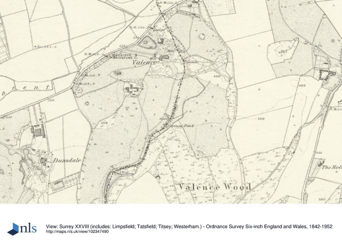
Valence lies astride the boundary of Westerham and Brasted parishes, on the south side of the A25. Brasted is situated c1.5km to the east, Westerham c1km to the west, and Sevenoaks c8.5km to the east. Dunsdale lies c0.5km south-west of Valence, towards Westerham.
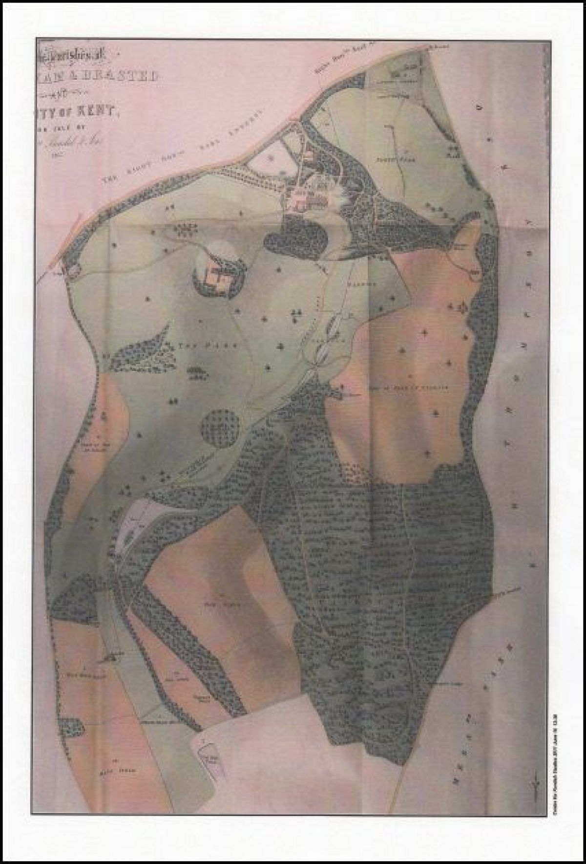
The c80 ha site of historic interest is situated on the north slope of the Greensand Ridge amid expansive areas of undulating parkland, woodland and a steep-sided valley. It is bordered to the north and to the north-west by the A25; to the north-east by a belt of trees that separates open pasture from an industrial estate (the site of the former C18 kitchen gardens) and a former quarry; to the east by a tree belt that bisects a golf course, and at its most south-easterly point by Cutmill Pond. To the south and the west, the site is mainly bordered by pasture and woodland adjoining Dunsdale Wood Farm and Dunsdale House.
ENTRANCES AND APPROACHES
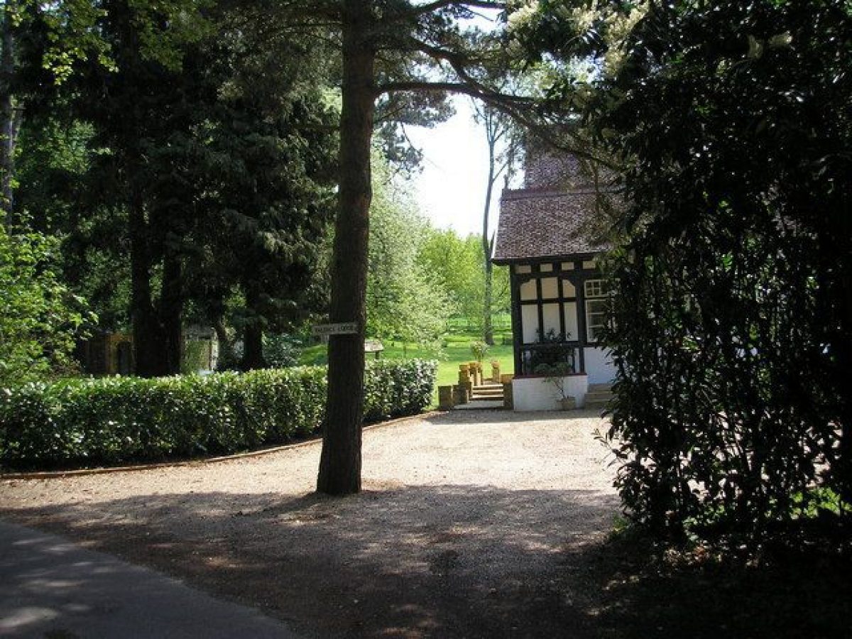
Valence is approached from the south side of the A25, through a tarmac drive (opened in 1997) framed by woodland and shrubbery. The entrance to the drive is flanked on each side by signs set into free-standing brick piers, marking the joint entrance to Valence School and Westerham Golf Club. The drive runs initially for c80m in a south-easterly direction before turning in an easterly direction for c150m, bisecting the remains of an avenue of lime trees which once led directly from the site's western boundary to the former C18 Valence house. A number of the limes, first recorded in 1769, survive from that period but there are no visible remains of the C18 model dairy which once stood at the eastern end of the avenue. The drive then divides in three directions: north for c220m to the C19 Brasted Lodge, situated at the former main entrance to the estate on the A25 and now (2011) in separate ownership; to the east for c50m to the golf club entrance; and to the south-west for c120m where it passes through an area of parkland studded with specimen trees, including wellingtonia, cedar, cypress and a small plantation of spruce, before arriving at an automated gate barrier. Just beyond the barrier the school comes into view as the drive ascends steeply through open parkland. After c300m metres, the drive diverges in four directions: southwards for c80m to arrive at the tarmac forecourt front of the school; westwards to a trade entrance to the rear of the school; north-westwards to outbuildings including the former C19 coach house and stables, now (2011) used variously for staff accommodation and maintenance works; and northwards through open parkland before circling and descending south-westwards for c0.5km through woodland to the school's exit at Valence Lodge. This lodge is also on the main A25 road and now (2011) in separate ownership.
Approximately c0.6km south of the main entrance to the school, also on the south side of the A25, are Dunsdale Lodge and, another c0.5km further south, Westerham Lodge. In the late C19, these lodges formed the third and fourth entrances to the then-combined Valence and Dunsdale estates but are now (2011) in separate private ownership.
GARDENS AND PLEASURE GROUNDS
The formal gardens and pleasure grounds lie mainly to the south-west of the mansion and include the remnants of Henry Milner's terraced and formal gardens.
Immediately south-west of the mansion, a gate set into a 2m palisade fence forms the entrance to a courtyard garden. The garden, c20m square, is laid out on a former part of the lower terrace, and is largely enclosed on its northern and eastern sides by contemporary school buildings. On the western border of the courtyard stand the only remnants of Milner's designed garden (Robinson): a c4m wide rockery and a c10m high cascade (no longer flowing), with a c3m wide pool below, safeguarded by a wooden fence. Various plants in the rockery, including bamboo, acers and ferns, are largely overgrown. Also growing in the rockery are two 8m tall fastigiate yew. In the centre of the courtyard, on the former site of Milner's parterres, stand two semi-circular raised beds with ornamental planting, surrounded by brick and tarmac landscaping and two small areas of lawn. The conservatory, which once stood west of the mansion, and Milner's parterres have not survived.
Immediately south-west of the courtyard garden, a tarmac path ascends in a south-westerly direction, bordered by low, post and rail fencing and various trees and shrubs, including holly, heathers and acers. After c50m, a fork in the path turns in a north-westerly direction for c10m before arriving at the upper terrace. This terrace, the site of the former croquet and tennis lawns, is dominated by an oval-shaped, undulating lawn, c50m x 80m, studded with specimen trees including a copper beech, wellingtonia, two large cedars (approximately 200 years old), and a turkey oak. The terrace is encircled by a tarmac path, and four C21 single-storey, chalet-style school buildings stand on its southern and western edges. On the northern side of the terrace, a smaller area of lawn, 25m square, is dissected by crossing tarmac paths, with Milner's rockery visible from its north-eastern edge.
The upper terrace is bordered on its western boundary by steeply-sloping woodland. Its southern boundary is bordered by a mixed variety of trees and mature laurel shrubbery. From the south-eastern corner, the tarmac path descends in a northerly direction for c60m through various trees and shrubs, including English oaks, acers and heathers, before meeting the path from the lower terrace.
Approximately 30m south-east of the mansion a sloping path leads southwards to a five-bar wooden gate (signposted Geal's Way) and a winding tarmac path, forming a nature trail, descends through steep woodland to a c20m x c40m clearing. The clearing, formerly used as an ice rink (2nd edition OS map), is now (2011) a recreation area for outdoor activities. From here the path descends eastwards for a further c10m to reach the valley floor.
PARK
The significant features of the park are the ponds, lakes and watercourses which stretch from south to north for c1km through a broad valley between, for the most part, steeply-sloping woodland to the east and undulating parkland to the west. These features have remained largely unchanged since the C18.
The first stages of the park's development, including watercourses and cascades, began in the mid C18 (described by Pococke in 1754 and illustrated on the Andrews, Drury and Herbert map of 1769).
In the late C18, clearly defined tree boundaries, open parkland studded with specimen trees, ponds and watercourses (shown on the estate map of 1799), all reflect Brown's significant influences, and appear to include features first described in print by Hasted (1797-1801) and Neale (1819).
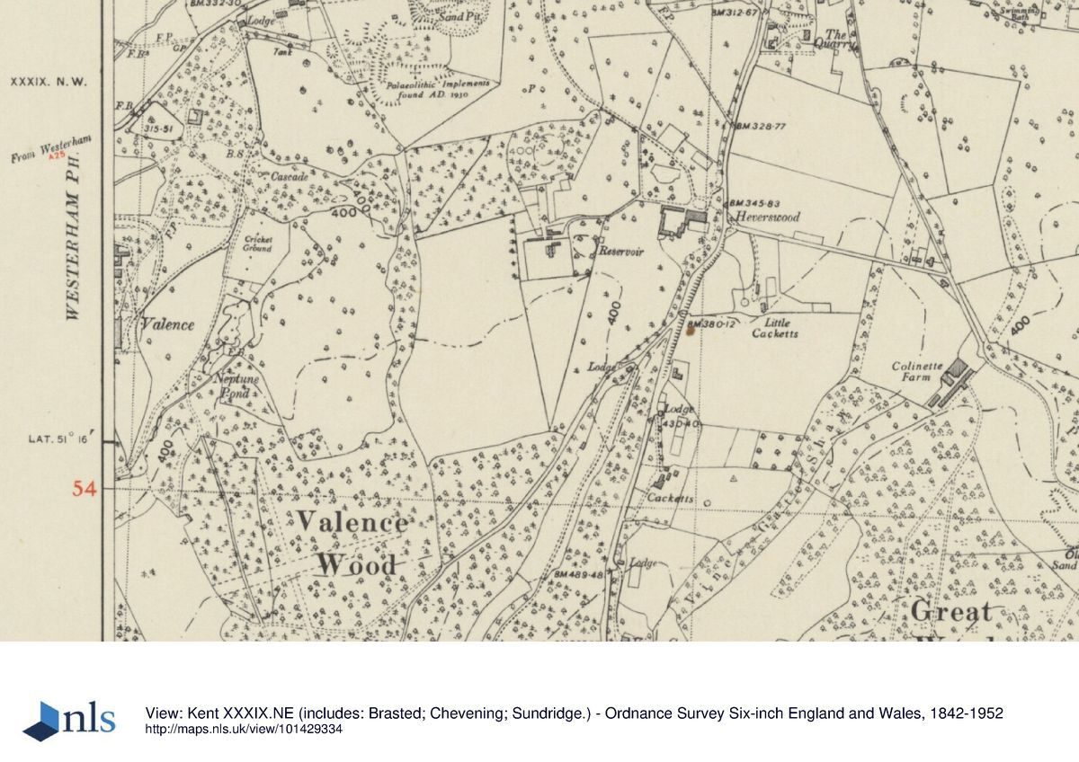
In the mid C19, part of the parkland area close to the C18 house was replaced by more formal elements, including parterre gardens and pleasure gardens. By 1857, evidence shows that the park, in its mature state, covered an extensive area (c85 ha) to the east and to the west of the C18 house (1857 estate map). By the end of the C19, a large area of parkland to the west had significantly altered with the building of the C19 mansion, and the creation of more formal gardens and pleasure grounds. Further distinctive changes included the re-configuration of fishponds to become Neptune Pond. In the mid-C19, the area of parkland to the east of the C18 mansion was used for tillage and in the late C20 was converted to a golf course.
Located at the valley's southern-most point, 0.7km south of the mansion, lies the C13, triangular-shaped Cutmill Pond (c 0.17ha), now (2011) in separate private ownership. Immediately south-east of Cutmill Pond, an underground spring emerges into a small holding basin (2x4m), characterised by very clear waters. This is the source of the stream which runs underground into Cutmill Pond.
The pond narrows to the south and is bordered to the east by sloping managed woodland, and to the west by sloping pasture. At the water's edge, a belt of alder trees grow on the eastern side, and, on the western side, a variety of trees including mature oaks. East of the pond, a woodland path runs north to south for c120m before terminating at the boundary of the estate.
From the northern end of Cutmill Pond, the water diverts and flows along a narrow rill, c6m x 1m, bordered by flagstones, before cascading c6m into a c4m x c6m split-level stone-built chamber, which accommodates significant remnants of a mid-Victorian hydraulic ram and a water-wheel, built in 1858. Approximately 10m from the chamber stands a single-storey building constructed of brick and tile with a pitched roof, probably the site of a hydraulic ram pump and water tank, installed in the late C19 (4th edition OS map).
Northwards from Cutmill, the water forms a natural stream flowing along the valley floor through woodland of alder, oak and beech for c350m before arriving at Middle Pond. The southern approach to Middle Pond is denoted by a brick, arched bridge, approached from the west via a Victorian wrought iron gate set into wrought iron railings.
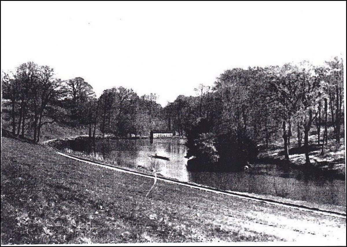
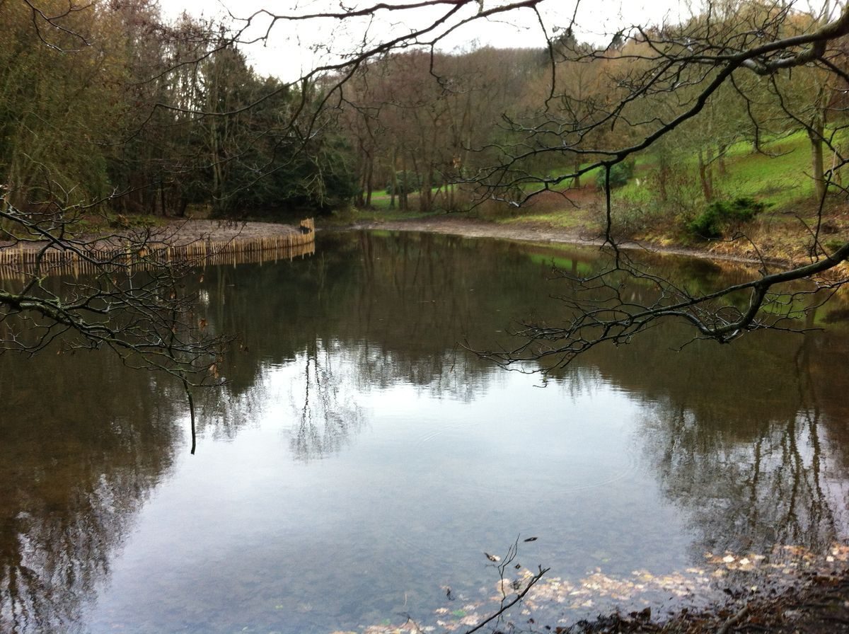
The triangular-shaped Middle Pond, 0.5ha when full, is currently (2011) being restored, temporarily reducing the area of water to c0.2ha. At the southern end of the pond, a former island (clearly shown on the 1857 estate map), planted with several veteran yew trees, is now (2011) almost surrounded by dry land. The pond is bordered to the west by a broad, grassy path, and managed woodland. On the eastern side, dredging has created a mound of clay c30m x 50m, fenced off from the pond. On the north-eastern and north-western sides, restoration work has exposed stone-built platforms, possibly the sites of former boat moorings. The platform on the north-western side is close to where a Victorian boathouse was once located (archive photograph). The very north-eastern end of the pond (cleared of bulrushes in 2011) is partly dry, exposing a stone head wall and dam, part of a stone pond lining, and a stone-framed sluiceway. Immediately behind the sluiceway, and built into a woodland bank, lies a rocky outcrop c5m high, the site of a former cascade. Early maps show a distinct spout to the north-east corner of the lake, believed to have formed a leat (estate plans 1857 and 1874).
To the north-west of Middle Pond, recent (2011) penstock cleaning has allowed water to pass into a feeder stream which flows north-eastwards through woodland and is bordered to the west by alder and beech trees. Some 100m further north-eastwards and set in undergrowth east of the stream, a derelict brick water tank is situated on a raised earth mound. Nearby, a broken iron pump lies beside the stream. A further c25m north-eastwards, a wrought-iron gate and railings mark both the termination of the broad path from Middle Pond and the southern boundary of the school grounds.
The stream continues in a north-easterly direction before diverting into a narrow, shallow concrete channel, and meanders for 80m through overgrown woodland. The channel then straightens and forms a part brick and part stone-lined deeper channel. The water continues to flow for a further 50m before cascading 5m down a rocky outcrop into Neptune Pond.
The irregular-shaped Neptune Pond, re-configured by Milner in the late C19 from pre-existing fishponds (last recorded on the Valence estate map of 1874) lies c160m south-east of the mansion and covers an area of 0.27ha. Bordered by alders, silver birch and aquatic plants, the pond is spanned at a narrow point in the middle by a brick built footbridge with iron railings (replacing the Victorian wooden rustic bridge - archive photograph), beyond which stands a tarmac seating area. To the north of the bridge the pond widens and encircles an island of alders with a small hut for wildlife. Approximately 10m east of the bridge, at the summit of a steep, overgrown woodland bank, stands a mid-C19, tunnel-shaped, red-brick ice house (first recorded on the estate plan of 1857) with a later wooden entrance door. The ice-house (in separate private ownership), extends into the bank for c10m and appears to have survived intact. About 10m north-east of the ice house lies a 0.14 ha, late C20 ornamental pond, also in separate private ownership.
Located c250 metres north-east of the mansion, to the north of Neptune Pond, lies a cricket ground c80m x c100m, surrounded by a belt of mixed trees. Approximately 70 metres north of the cricket ground, lies an area of woodland, formerly known as Cascade Wood, which formed part of the pleasure grounds in the C19, with meandering pathways through a wilderness and shrubbery, and a rotunda that has not survived (sales particulars, 1857). To the east lie a steep bank and the remnants of the c10m rock cascade that once flowed into Fountain Pond. Beneath the cascade, stands a dried-up and overgrown water basin. According to Lochen, this formed part of a Victorian pond within a larger C18 water basin, the morphology of which is still evident (personal communication).
Approximately 40 metres to the west of the cascade lies a 280m2 area of grass, the site of the former C18 house. This area is bordered to the east and north by the new (1997) drive. North of the drive, and c240m north of the current C19 mansion, lies a triangular-shaped area of land (3.2ha) now (2011) in separate ownership and currently (2011) being developed for housing. On its western edge, adjacent to the A25, lies the site of the C18 Fountain Pond, now dried up. A former island in the pond with mature yew trees survives (2011) and the pond is being partially restored (planning application 2008, granted 2009). Approximately 110 metres east of the pond lie the ruined Fountain Cottages, formerly Vuillamy's early C19 stables to the mansion and now (2011) being demolished to make way for new housing. At the northern apex of the site stands Brasted Lodge and almost immediately to its east a c5ha field, formerly part of Valence's parkland, and now in separate private ownership.
Immediately to the east and south-east of the mansion and associated school buildings, an area of open parkland (3.2ha) studded with broadleaf trees slopes downwards for c170m to the valley below. This area has remained parkland since the C18. On the eastern side of the valley, a c6.5ha area of land, now part of the golf course, was open parkland until 1997, and its far eastern boundary, bordered by a belt of trees, also formed part of the C18 historic landscape (estate map 1799).
To the north and north-west of the mansion, beyond the former stables and the current exit drive, lies an area of steep, overgrown woodland known as Rookery Wood. In the C19, this formed a wilderness with extensive meandering pathways within the wider park (sales particulars, 1857). On the northern edge of the woodland, close to the former site of the C18 mansion, lie the derelict remnants of a second ice house (possibly C18). South- west of Rookery Wood and c250m to the north-west of the mansion, lies an area of former parkland, referred to by Neale as the ‘western extremity' of the Valence estate. Historically, this area was known as Twelve Acres, and is now (2011) occupied by a house and garden of that name, surrounded by woodland, in separate private ownership. Before Watney built the Victorian mansion, there was a route along the western perimeter of the site, across open parkland before bearing south-east to meet Middle Pond.
DUNSDALE
Approximately 0.5km south-west of the Valence mansion, and in separate private ownership, lies Dunsdale House, built c1999 (planning application 1997) on the site of the former mid-C19 Dunsdale mansion. Its c11ha of land includes woodland and significant surviving features of Edward Milner's mid C19 designed garden.
The centrepiece of Milner's design was a serpentine-shaped artificial lake spanned at a narrow point by a stone bridge and fed by a series of small pools and cascades. According to Lochen, "the water came from Cutmill Pond and pumped over the hill by the water wheel built in the same year as Dunsdale mansion via a reservoir near Gilham's" (Lochen p.106). To the south and west of the mansion, close to the site of mature woodlands, specimen trees including Californian redwoods were planted. "Herbaceous beds adjoined the conservatory, a folly to the north, a bowling green and tennis court within the woods overlooked by a rustic summer house and numerous meandering woodland paths" (ibid p.109).
Evidence suggests that the lake and its stone bridge, derelict in the late C20, have been restored, together with some parts of the garden (planning documents and aerial view, 2003). There are areas of farmland to the east (c12.5ha) and west (c7.5ha) of Dunsdale House, now (2011) held in multiple ownership, thus still reflecting the fragmented historical ownership of this part of the estate. To the north-east of the house there is a narrow (c50 metres wide) area of parkland which runs west for c0.5km until it reaches Westerham Lodge, the C19 main entrance to Dunsdale mansion, and now in separate ownership. Around 60m to the south-east of Dunsdale House, lies Dunsdale Wood Farm, also in separate ownership, where evidence suggests that the walled kitchen garden, 0.2ha, which formerly belonged to Dunsdale mansion, survives virtually intact.
Detailed description updated 04/04/2014
Sources
Books and articles
J.R. Lochen, Valence: a Changing Landscape. A History of the Estate and its People (published privately 1992)
T Philipott, Villare Cantianum or Kent, Surveyed and Illustrated (1659)
A. McConnell, Oxford Dictionary of National Biography: Jacob Verzelini (Oxford University Press 2004-11)
R Pococke, Travels through England Vol II (1888 edition) p71-74
J. Brown, The Omnipotent Magician: Lancelot ‘Capability' Brown, 1716-1783, (Chatto and Windus, London 2011)
E. Hasted, The History and Topographical Survey of the County of Kent: Volume III (1797-1801)
P. Willis, Capability Brown's account with Drummonds 1753-83, Architectural History volume 27 (1984) pp. 382-391
J. P. Neale, Views of the Seats of Noblemen and Gentlemen in England, Wales, Scotland and Ireland Volume II (1819)
L. Vulliamy, List of Works Completed , Builder XXlX (1871) p.142
R. Kerr, The Gentleman's House, or how to plan English residences from the parsonage to the palace (John Murray, London 1865)
H.E. Milner, The Art & Practice of Landscape Gardening (1890)
Maps
R. Morden, Kent 1675-1703 (KHLC)
J. Andrews, A.Drury & W.Herbert, A Topographical Map of the County of Kent in Twenty Five Sheets 1769 (KHLC)
W. Mudge, An Entirely New and Accurate Survey of the County of Kent 1801
Estate Map, Dyson,Lambarde & Larkin 1799 (KHLC ref WU8 T/1)
Estate Map, accompanying title Deeds 1820 (KHLC ref WU8 T/1)
Part of Westerham Tithe Map and apportionment 1840 (KHLC)
Estate Map, 1857 (KHLC ref WU8 E11)
Estate Map, Martin & Hood 1874 (Valence School)
Estate Map, 1887 T.Way (Valence School)
Planning Application SE/08/022784 Landscape Plan Fountain Cottage (Sevenoaks District Council, 2008)
Ordnance Survey map: 25" to 1 mile
1st edition (1862-75)
2nd edition (1897-1900)
3rd edition (1907-1923)
4th edition (1929- 1952)
Illustrations
Various archive photographs and sketches reproduced by kind permission of John Lochen
Site survey photographs (2011)
H. E. Milner, Landscape Plan of Gardens to Conservatory included in bundle 3 of Frederick J. Robinson's schedule of architectural drawings (KHLC), reproduced in Lochen, appendix 22
Archival items
J.R. Lochen's research records, bundles 1-3, Sevenoaks Library recording Westerham church records of 1583, Brasted manorial court rolls for 1591 and Westerham manorial court rolls of 1608
R.A Vestey collection of title deeds, sales particulars, plans and maps 1579-1921 including:
- Deeds 1622-1897 (KHLC ref. WU8 T/1)
- Architects Drawings 1885-6 (KHLC ref. WU8 P1/3)
(See also Lochen appendix 6, p.176)
Lancelot Brown's personal account book, 1764 onwards (property of Mrs Morris of Colchester in care of the RHS library)
Architectural note from Henry Holland's account books, Sir John Soane Museum, London. Soane's price books (I-III), 1767-1782
Henry Holland's sketch book inscribed, 1770s, Sir John Soane Museum, London, reproduced in Lochen's research papers, bundles 1-3, Sevenoaks Library.
Valence sales particulars, 1857 (KHLC WU8 E11)
Planning Application SE/97/002130/FUL Dunsdale. Demolition of existing dwelling and erection of replacement dwelling, together with landscape works and repair of existing garden structures (Sevenoaks District Council, 1997)
Planning Application 04/00261/FUL Construction of Water Supply Borehole for reinstatement of garden lake (Sevenoaks District Council, 2004)
- Visitor Access, Directions & Contacts
Telephone
01959 562156Website
https://www.valenceschool.comDirections
The site is accessed from the A25, about half a mile west of the village of Brasted.
Owners
Kent County Council
County Hall, Maidstone, ME14 1XQ
- History
The following material was contributed by Beverley and Paul Howarth, Kent Gardens Trust:
SUMMARY OF THE HISTORIC INTEREST
A parkland, water and woodland garden, first developed in the mid C18, with later landscaping by Lancelot Brown in the late C18; further developments were undertaken by Edward Milner in the mid-C19 and by Henry Ernest Milner in the late C19, surrounding a late Victorian mansion.
CHRONOLOGY OF THE HISTORIC DEVELOPMENT
Valence spans the ancient parishes of Brasted and Westerham on the western border of Kent. The Valence name is attributed to Haimo de Valoines (or de Valoniis) who between 1147 and 1148 acquired the deeds to "ten parcels of undisturbed land at Brasted" from William, Earl of Gloucester (Lochen p.14). The earliest references to the estate itself may be found in the Westerham church records of 1583 and the Brasted manorial court rolls for 1591. The first dwelling house on the site, probably a farmstead, was built by a William Middleton between 1485 and 1509, during the reign of Henry VII (Philipott). Throughout the C16, until 1596, three generations of the Middleton family lived at Valence, and probably replaced the farmstead with a modest country house (Table of land ownership 1147-1950, reproduced from Lochen, Table 1).
In 1596, Valence was sold to a prosperous Venetian glass-maker, Jacob Verzelini (1522-1607), who used the estate for timber to supply fuel for his glass furnaces. At the time of his death in 1607 (DNB), evidence suggests that Verzelini's estate included a mill (probably Cutmill, extant since 1293) and Valence Wood (Westerham manorial court rolls of 1608 and the first title deed of 1622). It then passed to his eldest daughter Elizabeth, and through her marriage, to a Peter Manning.
By 1645, the Mannings had acquired 93ha of land in the Westerham and Brasted parishes, including 28ha known as Gillman's Farm, adjoining the Valence estate. By the end of the C17, the Mannings had probably built the first major house on the site of a modest country house (a significant house is illustrated on the Morden map of 1675-1703 and, by 1717, the property is known as Valence House in the ‘Articles for Purchase' documents dated 3rd March 1717).
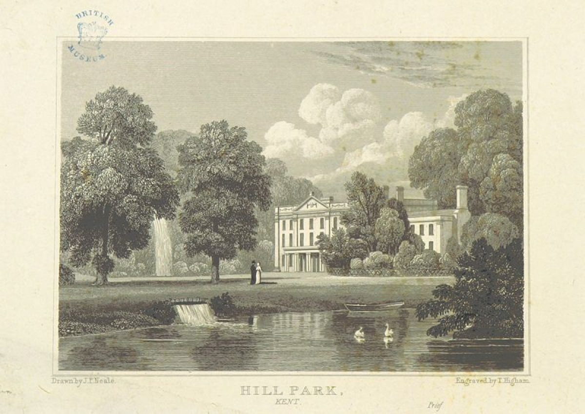
The C18 brought numerous changes of ownership. In 1753, the estate, which covered 182ha of land including Parris Farm to the west, with tithes for an additional 33ha, was sold to a former naval officer and subsequent parliamentarian, Captain Peter Denis (1713-1778) (sales particulars, 1753). In 1754, the prelate and anthropologist, Dr. Richard Pococke, vividly records the early designed Valence landscape. Fountain Pond and the cascade opposite Valence House are both described (the remnants of which can be seen today, 2011), as are a ‘serpentine river' and ‘canals' (Pococke). The canals are likely to be a reference to three rectangular fishponds, which are clearly shown, fed by a meandering stream to the south, on the earliest detailed map (Andrews, Drury and Herbert, 1769). This map also clearly depicts Fountain Pond north-west of the house, with two avenues of trees: one to the west and verified as common limes (Tilia europaea) dating from the 1760s (partially extant in 2011), and one to the north. Kitchen gardens are also shown to the north of the estate.
In 1771, Valence (including Parris and Gillmans farms) became the property of the Earl of Hillsborough (1718-93) who undertook a major development of the estate and its landscape, involving the landscape architect, Lancelot Brown (1716-1783) and his future son-in-law, Henry Holland junior (1745-1806) with whom, by 1773, he had formed a business partnership (Jane Brown). By 1775, Hillsborough had changed the name of the estate from Valence to Hill Park, and the adjoining land (Parris and Gillmans farms) became Hill Park Farm. Between December 1772 and June 1775, Lord Hillsborough paid Brown the sum of £1,200 (with an outstanding debt of £50) in respect of a commission relating to Hill Park (Brown's personal account book and Willis). Substantial refurbishments were made to the existing house which included some architectural improvements (Holland's account books, 1767-1782). The construction of various outbuildings, including a model dairy at the eastern end of the lime avenue, was also undertaken. Holland's sketch book depicts the interior of the dairy, designed for Lady Hillsborough and dated 7th July 1777 (photocopied extract of Holland's sketch book) and a C19 sketch and photograph illustrate its classical architecture (archive illustrations).
Significant alterations were also made to the landscape, emphasising greater informality. A middle lake or ‘larger fish pond' was made, whilst other ponds were created to the south (estate map, 1799). Hasted describes Hillsborough as "......having almost re-built this seat, and greatly improved the park and grounds about it" (Hasted p.171). Although, no other records of the work carried out by Brown appear to exist, the contractual sum of £1200 paid by Hillsborough was clearly not insubstantial. Near equivalent amounts that Brown received for other commissions cover, for example, the creation of lakes, islands and watercourses (Jane Brown). By 1783, when it was sold in its entirety to John Cottin, the size of the estate had increased to more than 263ha and included gardens, orchards, woodlands, watercourses, ponds and fish pools (sales particulars, 1783). In 1819, J. P.Neale's extensive description highlights the principal features of the landscape. Neale speaks of the park as "the distinguishing beauty of this delightful residence...a winding valley...considerable hills, sometimes almost precipitous...at other times, a broad and level slope to the edge of the lake below, in some places studded with majestic single oaks...a stream of pellucid water brawls along the bottom of the valley...the brook tumbles over a precipitous rock of natural production, the depth of 30 feet into a dark pool below" (Neale).
By the mid C19, Hill Park and Hill Park farm were again in separate ownership. In 1836, Hill Park was purchased by a David Baillie who paid £16000 for the house and 93ha of land (Vesty). More changes were again made to the house and outbuildings, and in 1839 some of the work was carried out by the architect Lewis Vuillamy (1791-1871) including the construction of "cottages, conservatory, stables etc" (Vulliamy). By 1857, when Hector John Toler, the third Earl of Norbury, had taken ownership, the sales particulars show that substantial changes had been made to the gardens and parkland areas, reversing expansive areas of informal landscaping to the creation of formal parterres to the north and south of the house with geometrically-shaped beds (Features of the park 1857, fig.72 Lochen, reproduced from sales particulars, 1857.)
By 1854, Hill Park Farm became known as Dunsdale when ownership passed to a Joseph Kitchen. Dunsdale occupies a small valley west of Valence and from the early C17 until the turn of the C20 was used largely for hop growing, arable farming, sheep and cattle grazing. Hazel groves were made for coppicing and harvesting cob nuts, whilst glasshouses and walled kitchen gardens were later put to use for the burgeoning market gardening industry (Vesty - sales particulars and estate maps 1622 -1857 and tithe survey 1843-5).
By 1858, Joseph Kitchen had instructed the architect Robert Kerr to build a mansion at Dunsdale in Victorian Gothic Revival style. The date 1858 is shown above the main entrance in a J.M Williams engraving (archive photograph), and the mansion was illustrated by Kerr in 1865 (Kerr). Kitchen also commissioned the landscape designer Edward Milner (1819-84) to make extensive improvements to the surrounding gardens. In 1880, the entire Dunsdale estate fell into the hands of trustees as Kitchen's assets went into liquidation.
By 1890, the Dunsdale and Valence estates became the property of a director of the Watney brewery company, Norman Watney. Dunsdale mansion became tenanted until the First World War when it was used by the Red Cross as a hospital to nurse the war-wounded. By 1929, the landscaped park and gardens immediately surrounding Dunsdale mansion had become neglected. According to Lochen, by 1992, the artificial lake (once the centre-piece of Milner's design) had dried up and the ornamental planting mostly destroyed. The growth of scrub and self-seeded trees ensued, and only the remnants of a stone bridge, a folly and an ice-house remained.
At Valence, Watney appointed the architect Frederick J. Robinson to construct an entirely new mansion, south-west of the old house, with additional stables, new entrances and lodges and a conservatory (Robinson's schedule of architectural drawings). He also directed Edward Milner's son, Henry Ernest Milner (1845-1906) to landscape the surrounding gardens (Milner's landscape plan of gardens). His designs included a rock garden and waterfall beyond the conservatory, where the dominant features were parterres. Footpaths led to upper and lower terraces. Tennis and rounders were played on the upper terrace lawn, whilst boating took place on the middle lake and occasional ice-skating on Fountain Pond (photographs - J Thonger, Lochen figs. 139-40). The rectangular fishponds were re-modelled to form two curvilinear ponds, with a footbridge spanning the narrow point in the middle where the ponds meet. These ponds became known as Neptune Pond, probably in recognition of a statue of Neptune that once stood on the site of the former C18 house. It was fed by a series of smaller pools and channels, and a cascade was created. The overall shape of Neptune Pond was not dissimilar to that of Edward Milner's design of the lake at Dunsdale (2nd edition OS map).
Between 1919 and 1949, there were several further changes of ownership of the 182ha estate. In 1949, Valence mansion and 20ha of land were purchased by Kent County Council. The Dunsdale estate and the remaining parts of Valence, including Valence Wood to the south and south-east of the estate, were sold to a Llewellyn Jones, a developer and owner of the building firm Jones and Harvey.
In 1951, Valence became a school for physically disabled children and a number of other school buildings were added over the years. In 1989, fire broke out at the school causing extensive damage (archive photographs) but the mansion was largely restored to Robinson's original designs using his architectural drawings.
In 1987, Valence Wood was severely depleted by the ravaging October storm. The opportunity was taken to fashion a golf course covering the area of Valence Wood, and the adjacent parkland to the north and north-east. This opened as a privately-owned golf club in 1997. Approximately 5ha of land to the north of the golf course are also owned by the golf club.
By 2008, a further 4ha of land were sold to a private developer. This included the site of the derelict C19 stables (later known as Fountain Cottages) adjacent to the original Valence mansion, and the remnants of the C18 Fountain Pond.
Valence School, and the residual 16ha of land, remain in the ownership of Kent County Council.
Detailed history updated 04/04/2014
- Associated People
- Features & Designations
Features
- House (featured building)
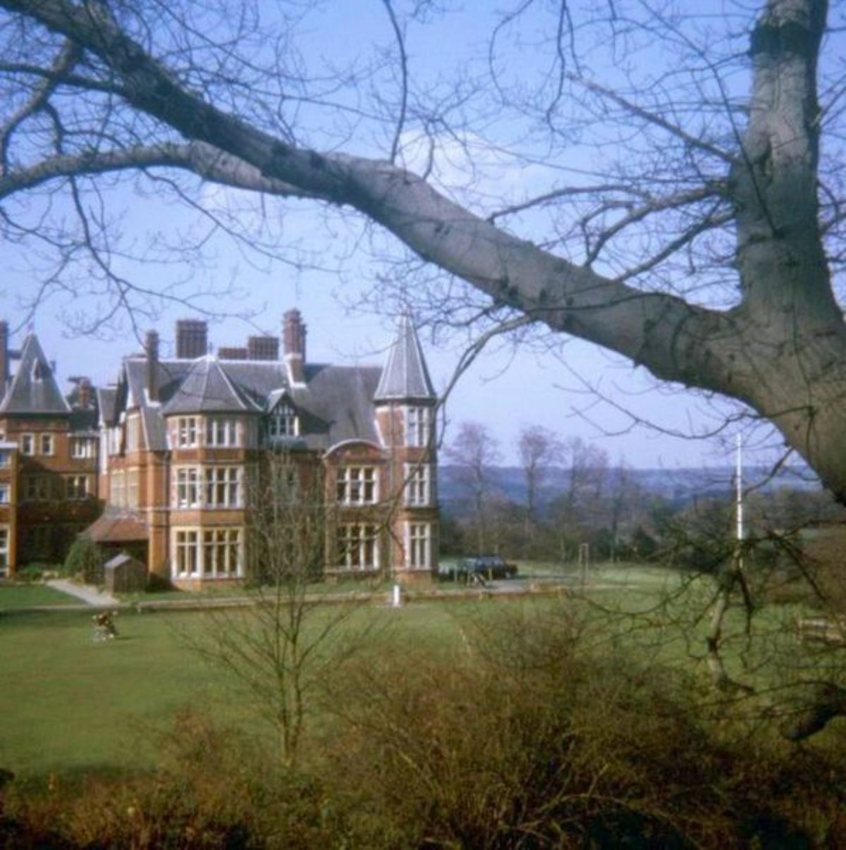
- Description: Valence School is a red-brick Tudor Elizabethan Revival style mansion, with two towers, stone and tile dressing, half timbered gables and a Cumberland slate roof. It is 9 bays wide and three storeys high, and was designed by the architect, Frederick J. Robinson. Built between 1885-87 by local builders, R. Durtnell & Sons Ltd. (estate particulars 1917 and architectural drawings), it replaced the C18 house formerly located c370 metres to the north-east.Valence School stands on a spur of high ground at c125 metres surrounded by areas of steeply-sloping parkland and woodland, with a valley to the east. From the east-facing front of the school, there are commanding views to the east and north-east across the valley, overlooking a golf course, former parkland to the Valence estate. To the south-west there are views across open farmland, with Dunsdale Wood on the horizon. To the north, there are far-reaching views of the hills of the North Downs.Adjoining the mansion to the north and to the west are two C20, flat-roofed school buildings. Twenty-five metres south of the mansion, a further single-storey C20 school building is located on the former lower garden terrace. Four hundred metres to the north of the mansion are farm-buildings which were once the stables and coach-house to the Victorian mansion. There are no listed buildings on the site.
- Earliest Date:
- Latest Date:
- Pond
- Description: A mill pond in the very top southern edge of the estate was equipped with a water wheel (now replaced by an operative hydraulic ram), in order to regulate the flow of water.
- Earliest Date:
- Latest Date:
- Pond
- Description: Below the millpond was a series of three small ponds (now reduced to two).
- Earliest Date:
- Latest Date:
- Lake
- Description: Below the house there is a lake known as Neptune Pond. This is a very irregular naturalistic feature.
- Stream
- Description: The stream flows north from the lake to the cascade.
- Cascade
- Description: There is a 2O foot cascade in a copse adjacent to the entrance drive.
- Earliest Date:
- Latest Date:
- Stable Block
- Lake
- Description: A large lake with two islands was created adjacent to the original house.
- Gate Lodge
- Description: Four entrance drives, each with a lodge, were created.
- Earliest Date:
- Latest Date:
- Drive
- Description: Four entrance drives, each with a lodge, were created.
- Earliest Date:
- Latest Date:
- Planting
- Description: The terraced lawns and formal beds were replaced in the 1930s by heather and low maintenance shrub beds.
- Earliest Date:
- Latest Date:
- Grotto
- Description: There is a grotto behind the house, planted mainly with rhododendrons, azaleas and heathers.
- Terrace
- Lawn
- Description: Terraced lawns with copper beech, weeping holly and conifers are remnants of the 19th-century garden.
- Earliest Date:
- Latest Date:
- Kitchen Garden
- Description: Opposite the main entrance lodge is the old walled kitchen garden. This is still in use and is cultivated by the handicapped pupils of the school.
- Key Information
Type
Garden
Purpose
Ornamental
Principal Building
Education
Survival
Extant
Open to the public
Yes
Civil Parish
Westerham
- References
References
- Kent Gardens Trust {Capability Brown in Kent} (Kent Gardens Trust, 2016) Capability Brown in Kent