Introduction
Hawkstone has a landscape park which is in divided ownership. Other features include the follies, an area of cliffs, caves and crags within woodland. The site is remarkable for its realisation of the late-18th-century concept of the sublime, as embodied in the natural landscape. There is also a golf course.
Terrain
Mainly flat, with steep outcrops to the west of the hall.
The following is from the Register of Parks and Gardens of Special Historic Interest. For the most up-to-date Register entry, please visit the The National Heritage List for England (NHLE):
www.historicengland.org.uk/lis...
Gardens, grounds and extensive and much-visited pleasure grounds associated with a country house, the last developed from the mid-18th century on and around sandstone hills and including a grotto, various buildings and lakes.
DESCRIPTION
LOCATION, AREA, BOUNDARIES, LANDFORM, SETTING
Hawkstone lies c 17km north of Shrewsbury, the main A49 Shrewsbury to Whitchurch road passing west of the park. Hereabouts, on the southern part of the Cheshire Plain, the land is largely flat. West of the Hall however is a series of steep outcrops of red sandstone, which in the second half of the C18 formed the setting for the sublime landscapes constructed there by the Hills. The area here registered is c 550ha.
ENTRANCES AND APPROACHES
The Hall is approached from Marchamley on the east edge of the park. Until c 1780 the road from Marchamley was public; thereafter it became a private drive. At Marchamley there is a large, two-storey, timber-framed lodge of the mid C19, from which a drive runs 1.5km north-west through the park before approaching the main, west forecourt via the service buildings and kitchen gardens north-east of the Hall. In 1853-4 a new drive was created from Weston village c 2km south-west of the Hall, passing south of Grotto Hill via a new cutting before making a terraced, axial approach from the east along the line of the old avenue. From this there are the best views of the Hawk Lake. At the drive end, on the edge of Weston village, is Hawkstone Lodge (listed grade II), a large and decorative, T-plan, brick and stone building of 1853-4. This drive was not used in the late C20. Nor was that which formerly approached the Hall from the north. At its end is North Lodge (listed grade II), a pair of late C18 (present 1795) ashlar pavilions. That to the north-west is little altered, whereas its pair has been extended and heightened.
Pedestrian access from the Hall to the main parkland features in the C19 and early C20 was via a tree-lined walk, overgrown in the late C20, which leads south from 300m south of the Hall to a point above Vineyard Cottage. Public access in the late C20 to what are marketed as 'The Follies' is from a car park on the south-west side of the Elysian Hill, off the Weston to Hodnet road. The modern trail begins at the Greenhouse, which in the early 1990s was restored as a ticket hall, visitor centre and restaurant, and then ascends up to the White Tower at the south end of the Terrace. From the time the Hawkstone Inn was built c 1790 until the earlier C20 the tour usually began there; previously it had begun at the Hall.
PRINCIPAL BUILDING
Hawkstone Hall (listed grade I) is of red brick with stone dressings, the west front of nine bays and two-and-a-half storeys. It was built c 1720 for Sir Richard Hill. Wings were added c 1750 for his nephew Sir Rowland Hill. Interior remodelling and other alterations were made by Lewis Wyatt in 1832-4. These works included a conservatory or winter garden behind the new south quadrant wall. A chapel was added to the south-east corner of the Hall in 1932 to a design by George Bernard Cox of Birmingham, and in the early 1960s the Hall was extended to the north-east when an accommodation block was built.
A conservatory (listed grade II) 50m east of the Hall was added 1832-4 by Lewis Wyatt. Its glazing was replaced in the C20 by cement-rendered panels when it was converted to a seminar room.
GARDENS AND PLEASURE GROUNDS
The Temple Walk, an axial gravel walk lined with Irish yews, leads east from the Hall for 300m, rising via three terraces supported by low stone walls. About 160m along it is an octagonal, grey sandstone ashlar rotunda (listed grade II), one of a pair built before 1784. The other, at the end of the Walk, fell down in 1957. A shrine to Our Lady now stands here. South of the walk is a shrubbery with specimen trees. Within it, roughly parallel with the walk but extending east of it, is a straight, 190m long and 15m wide, canal-like fishpond, at the east end of which is a stone bridge carrying a path. The canal may be an adaptation of an early C18 garden feature.
North of the Temple Walk is a shrubbery with large numbers of mature specimen trees extending north for 140m, to the south wall of the kitchen garden. Paths, some with Irish yews, twist through this. Concealed in a clearing in its north-east part is an orchard. West of this is an irregular, 60m long, Lily Pond, in the late C19 (OS) with about ten small islands. Two small pools set among a rockery lie off its south-east end. Overlooking the Pond, built against the south wall of the kitchen garden, is a latticed iron pergola, 7m in diameter and with an umbrella spoke-like roof structure supporting a conical thatched roof. In the late C19 this was flanked by two identical pergolas. Immediately south of the Pond is a flower garden with gravelled paths defining a cusped, starfish-like, design. Pergola, Pond, rockery and flower garden are of mid C19 date, although whether they can be attributed to Gilpin (see below) or to a phase of improvement in the 1850s is uncertain.
The modern gardens lie within a framework established in the 1720s by Francis Chambre, who was sent to supervise the work, and Joseph Holford (d 1726), the Hills' gardener. East of the Hall was a parterre garden, while on the rising slopes to the south was planting cut through with diagonal walks. On the west side were inner and outer courts (both removed by 1821); in 1725 the latter, which was pebbled, was supplied with gates by Robert Davies of Wrexham. An elm avenue was planted on the western axis in 1724, and there was also one to the east. The grounds east of the Hall were improved in the early 1830s and William Sawrey Gilpin (d 1843) was called in in 1832.
PARK
Two features stand on the rising parkland south of the Hall and the axial approach from the west. Some 200m west of the Hall a box-like quarry is cut back into the hillslope near its crest. A 5m high round-headed alcove is cut into its north face, and there are remains of what was apparently a rusticated stone facade around it. From this seat there would have been views over the Hall, the Hawk Lake and the extensive landscape to the north and east. Cut into the east face of the same quarry is an icehouse. About 300m south-west of the Hall a spring emerges from an exposed rock face to collect in a shallow, oval, brick-lined basin, probably mid C19. This represents the truncated remains of an octagonal summerhouse and cold bath already present by the 1780s and perhaps originating in the later 1720s.
The parkland features for which Hawkstone is celebrated are ranged on and around the 1.5km long, north/south group of sandstone hills which rise c 800m south-west of the Hall. Running across beneath Grotto Hill at the north end of the hills is the c 3km long Hawk Lake, begun c 1783 and extended c 1786 by William Emes (d 1803). Emes was also responsible in the 1780s for an 800m long serpentine lake at the south of the end of the hills, Menagerie Pool, wooded and overgrown sections of which remain on the south side of the road from Weston to Hodnet. About 800m south-west of the hills is the Hawkstone Hotel, built c 1790 to accommodate visitors to the park. Since c 1935 it has served as the clubhouse for the golf club whose course extends from the Hotel up to and around the base of the hills.
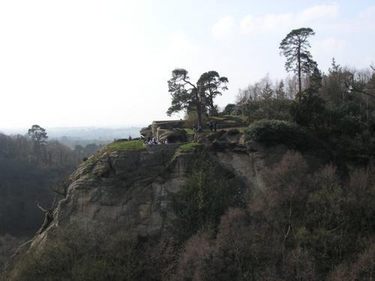
The main extant features of the landscape will be described according to the itinerary followed by C19 visitors which departed from the Hotel, rather than the modern one which begins south of Elysian Hill (see above). Many other structures, scenes and views are mentioned in historic sources, and elements of many of these can still be located. About 500m north of the Hotel, at the south-west end of Hawk Lake, is a late C18 brick windmill (listed grade II), which with Neptune's Whim (a watergod figure and a Dutch cottage, neither extant) to its south, conjured up a picture reminiscent of Ruysdael. From here the route led past Red Castle Hill, the westerly outcropping hill which takes its name from the castle (listed grade II) of 1227 and later constructed thereon, and the Lion's Den (listed grade II), a recess formerly with a lion's statue cut into the east end of the ditch between the castle's two wards, to the thatched Gingerbread Hall (so-called from the C19, earlier the Temple of Patience; restored 1990s). This stands below the east side of Grotto Hill, the north end of the main range of hills; here C18 and C19 visitors would await a guide. The path then ascended to the Grotto (listed grade II), under construction in 1765, which since c 1800 has normally been entered via the Dark Passage, a 100m long tunnel from the east. The Grotto (now missing almost all its elaborate decoration which included shells, slag, coral and ore-encrusted walls and coloured glass in its windows) comprises a series of pillared caverns, from which the visitor emerges onto a precipitous hill-edge terrace with vertiginous views of the Red Castle and across the level countryside westward to Wales and northward to Cheshire. On the hilltop above the Grotto is an artificial ruin (listed grade II, present by 1778) with a gothic arch which frames a view of The Citadel 1.5km to the south. Scots pines are probably part of the original late C18 planting.
From Grotto Hill the visitor crosses to the main hilly range, the Terrace, via the Arch (listed grade II) across the Weston Drive cutting. Some 300m south-east of the Arch is the thatched Hermitage (present by 1787; restored 1990s). From this the path continues south-east for 450m, through dense rhododendron and some mature coniferous specimen trees (probably mid C19, already noted admiringly in 1875), to the Monument (or Obelisk) (listed grade I), a c 30m high column topped with a statue of Sir Rowland Hill erected in 1795 on the highest point on the estate. Two hundred metres to the south, at the south end of the Terrace, is the White Tower (listed grade II), a red-brick, octagonal gothick tower of c 1780. From here the path descends steeply, crosses the south end of Fairy Glen, and proceeds to the south side of Elysian Hill. Here, c 250m west of the White Tower and just beyond the site of the Menagerie, is the Greenhouse (listed grade II). This (now the ticket hall) is an orangery-like sandstone building, battlemented and with a row of five tall, gothic-arched glazed openings along its south facade. Present by 1783 this collapsed in 1952 and was restored c 1990.
The Citadel (listed grade II*), 600m to the south-west, was built in 1824-5 to a design by Thomas Harrison of Chester to accommodate Sir Rowland Hill's mother and her sister-in-law. This replaced an earlier Citadel (parts of which, listed grade II, are incorporated in the rear of the present building), built c 1785 on the site of an older house and occupied by the Hills' steward. It is a squat building, triangular in plan, with a low, round, two-storey battlemented tower at each corner. About 100m south-west of The Citadel is a mid C19 octagonal rustic summerhouse (listed grade II), and c 120m south-east of the house an early C19 icehouse (listed grade II).
Other structures in the park include Ranger's Lodge (listed grade II), c 1km east of the Hall's pleasure ground, a substantial early C19 and later building.
The lower parkland, with the principal exception of the golf course, is largely featureless arable farmland. In North Park, south of North Lodge, there is a caravan park. When Sir Richard Hill inherited in 1783 the Hall and its grounds were surrounded by an agricultural landscape of long-enclosed fields. Precisely when the lower parkland was created is uncertain; it would seem probable it occurred at about the same time the Hawk Lake was created, in the mid to late 1780s.
There was a deer park at Hawkstone in 1357. Its relation to the later park is unknown.
KITCHEN GARDEN
About the 1740s Sir Rowland Hill constructed a kitchen garden known as The Vineyard 700m south of the Hall. This, which stands on a steep, south-facing slope, had mock fortifications. Sandstone retaining walls, terracing and a gothick tower (all listed grade II) survive.
About 1780 a new walled garden c 300m north-east of the Hall was constructed. The brick walls and some sheds survive but the interior is lacking any structures and is a paddock. In a compartment at the west end of the garden is the Redemptorists' cemetery. A substantial stables range to the north-west of the kitchen garden is of the same date. On the stables' north side is the home farm, where construction of a new farmhouse (not extant) began in 1723.
REFERENCES
The Victoria History of the County of Shropshire i, (1908), p 494
Country Life, 123 (27 March 1958), pp 640-3; (3 April 1958), pp 698-701; 124 (3 July 1958), pp 18-21; (10 July 1958), pp 72-5; (21 August 1958), pp 368-71; 177 (9 May 1985), pp 1244-7; no 43 (27 October 1994), pp 44-5
Archaeological Journal 138, (1981), pp 43-4
Hawkstone: A Short History and Guide, guidebook, (1993)
D McBride, A History of Hawkstone (1993)
Maps
J Rocque, Map of Shropshire, 1752
Map of the Manor of Hawkstone, no date (around 1783), (4133/2), (Shropshire Records and Research Centre)
OS 6" to 1 mile: 1st edition surveyed 1879(80, published 1880-8
OS 25" to 1 mile: 1st edition surveyed 1880, published 1881; 2nd edition surveyed 1900, published 1901
Archival items
Sale catalogue 1915 (SC/1/42), (Shropshire Records and Research Centre)
A collection of Hawkstone material is held at the Gardens and Landscapes section, Dept of Archaeology, The King's Manor, York.
- Visitor Access, Directions & Contacts
Access contact details
The Follies area is open daily through the summer season, with more restricted hours at other times.
- History
The following is from the Register of Parks and Gardens of Special Historic Interest. For the most up-to-date Register entry, please visit the The National Heritage List for England (NHLE):
www.historicengland.org.uk/lis...
HISTORIC DEVELOPMENT
Hawkstone was acquired in 1556 by Sir Rowland Hill (died 1561), Lord Mayor of London, who was investing in land. His descendant Richard Hill, in the 1690s Deputy Paymaster in Flanders, built up the estate and rebuilt the Hall following his retirement from public affairs in 1708. He died in 1727 and was succeeded by his nephew Sir Rowland Hill (died 1783) who not only remodelled the Hall but also extended his estate by purchasing lands in Redcastle township (1737-56) and, probably in the 1740s, began to create Hawkstone's extended pleasure grounds. His son and successor Sir Richard Hill (died 1809) enlarged the park and added considerably to the number of attractions. Like his father he was a promoter of Calvinistic Methodism and employed large numbers of the local poor in undertaking his schemes. From the outset visitors were encouraged. They included Dr Johnson (1774) and Sir Richard Colt Hoare (1801). A Description of Hawkstone was published in 1766, and the first edition of Rodenhurst's much-reprinted Guide in 1783. An inn (the modern Hawkstone Park Hotel) was built for visitors around 1790. Sir Richard was succeeded by his brother Sir John (died 1824). His heir was his grandson Sir Rowland, who in 1842 succeeded to his uncle's viscountcy. A spendthrift, he altered the house and grounds and extended the park eastward towards Marchamley. When his son the third Viscount, Rowland Clegg Hill, inherited the estate in 1875 it was heavily mortgaged and in 1894 he was declared bankrupt. On his death in 1895 a sale of the Hall's contents was held. In 1906 the fourth Viscount sold off the Hall and surrounding parkland, which changed hands once more (albeit with a reduced acreage) in 1913 and again in 1926 when the Hall and around 10 hectares were purchased by the Redemptorist Fathers, its owners in 1999. The last edition of the Hawkstone Handbook, which had first appeared in 1894, came out in 1934, and in 1935 the lower parts of the park became a golf course with the Hotel as the clubhouse. The more hilly parts of the landscape and the buildings thereon became ever-more neglected until the early 1990s when, after Hawkstone Park's acquisition by new owners, a major programme of restoration took place and in 1993 the landscape re-opened to the public.
Period
- 18th Century (1701 to 1800)
- Late 18th Century (1767 to 1800)
- Associated People
- Features & Designations
Designations
The National Heritage List for England: Register of Parks and Gardens
- Reference: GD1106
- Grade: I
Features
- Lake
- House (featured building)
- Now Hotel
- Earliest Date:
- Grotto
- Key Information
Type
Park
Purpose
Ornamental
Principal Building
Commercial
Period
18th Century (1701 to 1800)
Survival
Extant
Hectares
550
Open to the public
Yes
Civil Parish
Hodnet
- References
References
- {English Heritage Register of Parks and Gardens of Special Historic Interest}, (Swindon: English Heritage, 2008) [on CD-ROM] Historic England Register of Parks and Gardens of Special Historic Interest
- Page, W {Victoria County History: Shropshire, Volume 1} (London: Constable, 1908), p. 494 Victoria County History: Shropshire, Volume 1