Introduction
Goodnestone Park has gardens surrounding the house, which dates from 1704. The gardens have been regularly changed and redesigned since they were first established, and feature many separate areas, set in a wider landscape of park and woodland covering 1000 hectares.
Terrain
The site occupies the floor and the gently rising east and west slopes of a shallow dry valley, the land falling generally towards the north.The following is from the Register of Parks and Gardens of Special Historic Interest. For the most up-to-date Register entry, please visit The National Heritage List for England (NHLE):
A largely 19th-century formal garden with significant surviving 18th-century features and with 20th-century planting, set within an 18th-century park.
Location, Area, Boundaries, Landform and Setting
Goodnestone Park lies adjacent to the south end of Goodnestone village, c 1km east of the B2046, between the villages of Wingham, 2.5km to the north-north-west and Aylesham, 2km to the south-west. The registered site, which comprises c 15ha of formal gardens and ornamental planting, surrounded by a further 96ha of parkland, farmland, and woodland, occupies the floor and the gently rising east and west slopes of a shallow dry valley, the land falling generally towards the north.
The southern and eastern boundaries and most of the length of the northern boundary are bounded by narrow lanes while the western boundary is marked by a farm track; the site is largely hidden from view by internal roadside woodland belts. Beyond the lanes the landscape opens into rolling arable farmland, with occasional small woods and lengths of hedgerow. On the north side of the site, Goodnestone village extends some 400m southwards into the park and the site boundary follows the rear fence lines of the properties lining the main street (The Street).
Entrances and Approaches
The present approach to Goodnestone Park is from the north, through the village. The main street passes, on its west side, Holy Cross church and then Lindley House (within the site and listed grade II). It continues southwards to form the drive to the house, passing, c 50m south of Lindley House, the wooded frontage and entrance to the Dower House and its stable block (both also within the site and listed grade II* and II respectively). Some 80m further south a spur off the drive turns westwards towards the house, passing beneath the central arch of the stable and estate building block (listed grade II) then looping southwards to arrive on the gravelled forecourt of the principal, west front of the house.
The approach from the village street continues southwards past the east front of the house to Gate Lodge (listed grade II) which lies west of Bonnington Farm on the southern boundary. This route, now (1990s) a track providing private access to the park and farmland, formed the Old Park road which was the principal approach to the east front of the house in the C18. This is shown in Thomas Badeslade's view of 1719 and Thomas Hogben's survey of 1763. Alterations to the orientation of the house in 1844-5 required a new principal approach and New Park Drive was constructed. From the south, it enters the site at South Lodge (300m west of Gate Lodge) and follows a loose S-shaped course, now (1997) grassed, to the forecourt of the house. From the north, it enters off Saddlers Hill (100m west of its junction with The Street), at a lodge of similar design to South Lodge, and follows a straight, concrete-surfaced course southwards along a double horse chestnut avenue (replanted in the 1990s after felling and then storm damage) to arrive at the west front. This northern length of New Park Drive was in use as an approach to the house until the 1980s.
Principal Building
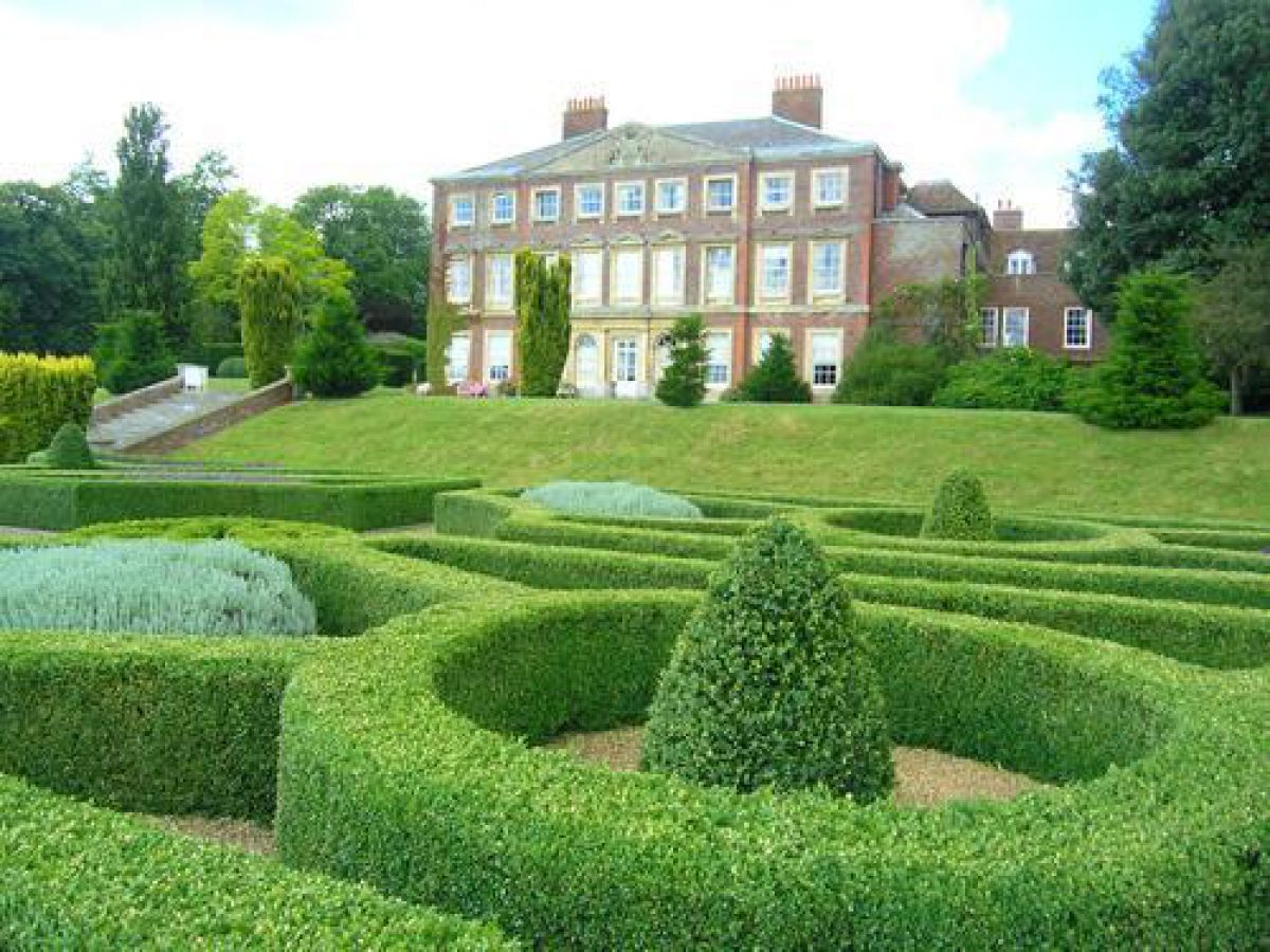
Goodnestone Park (listed grade II*) stands on the valley floor, at the centre of its park. It is a three-storey house of nine bays, built of red and blue brick with a hipped, slate roof. The house, built on the site of an earlier mansion (Hasted 1790), appears to have been completed by 1704 (the date on a brick on the east front) and was originally a two-storey, double-pile structure. It was considerably remodelled and given a third storey in place of its attics in c 1770-90 by Sir Brook Bridges, third baronet, who consulted the architect Robert Mylne (1734-1811) although the extent of his contribution is uncertain (guidebook). In 1844-5 further alterations were carried out by Sir Brook William Bridges, fifth baronet, to designs by the architectural firm of Rickman and Hussey of Birmingham (ibid). The entrance hall was moved to the present, principal, west front and the large pedimented Greek Doric porch added. The late C18 stucco finish was uncovered to reveal the original brickwork and the main fronts enriched with stone window casings.
Gardens and Pleasure Grounds
The gardens and pleasure grounds surround the house but lie largely to the west, north, and east/south-east, with formal, terraced gardens to the immediate east and west.
The east front of the house opens onto an upper terrace of lawns, laid out on the site of an early C18 terrace (Badeslade, 1719) which is bisected by an axial gravelled path, punctuated by Irish yews and extending 20m eastwards down a flight of stone steps (listed grade II) in a grass bank to a lower terrace. A broad yew walk (planted mid 1990s), formerly gravelled, runs north to south along the top of the bank. The lower terrace, laid to lawn with a mixed border at the foot of the grass bank, is c 80m deep and 158m in length and is raised above the Old Park drive on a brick wall, its moulded stone parapet (formerly embellished with urns) forming a low wall on the eastern, garden side of the terrace. The wall returns westwards for 25m to enclose the terrace at its south end while at both north and south ends, steps lead down through the wall to gates onto the drive. The terraces were designed by Rickman and Hussey in 1844-5 as part of the alterations to the house (Sell, Wade Postins 1992), the lower terrace occupying the site of its early C18 walled entrance court (Badeslade, 1719) which itself had been replaced by a carriage sweep by 1763 (Hogben). The northern end of the terraces, laid out informally with trees and shrubs, are enclosed from the stable block by a brick wall and by a screen of holm oaks planted in c 1850 (Sell, Wade Postins 1992).
From the west front forecourt and centred on the Doric porch, a grass amphitheatre rises in three tiers which are connected by three axial flights of stone steps and enclosed by wings of yew hedging (planted in the 1990s) on the top, west side. The amphitheatre, known as the Terraces and also part of the 1844-5 improvements by Rickman and Hussey (ibid), is built on the site of the early C18 walled great parterre and its flanking fruit garden (to the north) and wilderness garden and grove (to the south) which had been replaced by a single enclosure known as the Lawns and Walks by 1763 (Badeslade, 1719; Hogben, 1763).
West of the Terraces the axial grassed path leads between mature clipped hedges, flanked to north and south by lawns dotted with ornamental trees planted since the 1950s (guidebook), into the 170m long, double Lime Avenue. The Avenue, planted in 1984 to commemorate Lord FitzWalter's seventieth birthday. Its line preserves the axis of an early C18 avenue which divided the Great Wilderness Garden into two compartments. These survived in that form in the layout of the Lawns and Walks, which had replaced the Wilderness by 1763 and were recorded as light woodland by the early C20 (OS 1908). The former Wilderness compartments, to the north and south of the Avenue, have been planted since the mid C20 as a small arboretum of mixed native and exotic trees.
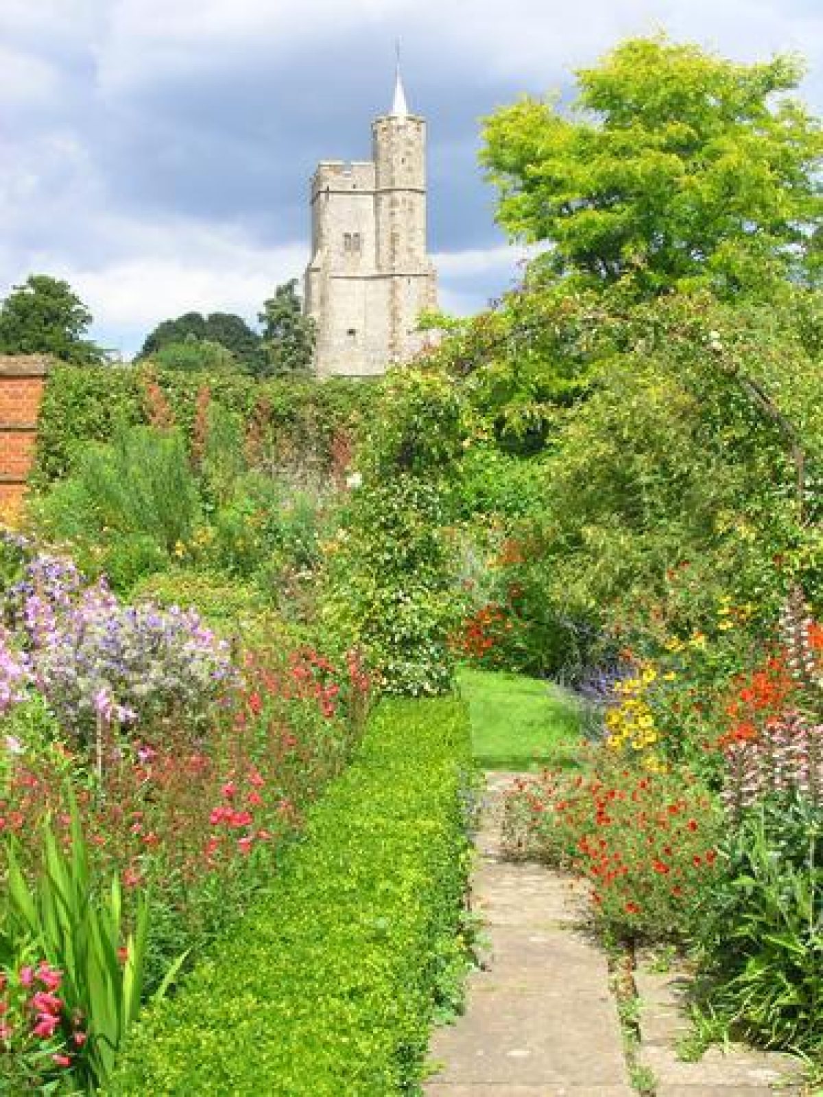
North of the Terraces, on lawns laid out with ornamental shrubbery, two mature cedars of Lebanon survive from the parkland planting carried out in the 1840s and 1850s. Some 150m north-west of the house and marked by a shrub-covered mound is the site of the Well House. Built c 1650, possibly as a hunting lodge, and incorporated into the north-west corner of the early C18 garden (Badeslade, 1719), it was demolished in 1965 (CL 1995). North of the Well House site the New Park Drive leads northwards into the chestnut avenue; to its east and extending from the estate buildings 170m northwards to the churchyard wall is a series of three contiguous, rectangular walled gardens (listed grade II). Running parallel between the gardens and the avenue is the Holly Walk, established on a north to south axis of the early C18 garden and known as the Church Walk by 1763 (Hogben). The Walk terminates at a pair of C18 stone-capped brick piers (listed grade II) at a gateway in the churchyard wall.
North-west of the Terraces and west of the chestnut avenue an area of mixed mature woodland contains a small water garden with a pool and rockery and a surrounding woodland garden with acid-loving shrubs and herbaceous planting. This area was laid out in the 1920s on the site of late C18 orchard and nursery gardens (Hogben, 1763). By the late C19, these compartments had been cleared and replaced by two clearings set within plantations (OS 1877).
Park
The park extends more or less equidistantly around the perimeter of the house and gardens. Hogben's survey of 1763 is the earliest record of the area of the park, when it occupied approximately the south-west and south-east quadrants of its present extent. South of the house and separated from the south boundary lane and from Bonnington Farm by woodland established between 1763 (Hogben) and 1872-3 (OS 1877), grazed pastureland is dotted with single and loose clumps of mature and newly planted (1990s) oak trees in a pattern established after 1763. Just within the southern boundary, c 130m north-east of Bonnington Farm, is an icehouse, built in a chalk pit. Towards the south-west boundary is an area known as Larkins which was laid out as part of improvements to the park between 1719 and 1763 attributed to a nurseryman, Samuel Driver (Sell, Wade Postins 1992). It is now (1990s) managed as set-aside land and contains two central, equidistant roundels c 45m in diameter, restored and replanted to their C18 appearance in the late C20. Larkins is enclosed along its north, west, and south sides by a woodland belt known as the Serpentine which contained a sinuous walk (now virtually gone) entered from the west side of the gardens.
The south-east quadrant, bounded to the north by a C19 sunken fence, lies on rising ground. Its lower slopes are grazed and the upper slopes, largely enclosed by woodland, are managed as set-aside. The parkland is planted with a series of six evenly but apparently randomly spaced roundels also attributed to Driver and restored in the late C20. The north-west and north-east quadrants are enclosed along their boundaries by significant woodland belts and laid out with a number of internal woodlands. These areas of parkland, the open land managed as set-aside, were imparked from fields in the late C18 or early C19 (ibid) although Hogben's survey shows two of the present plantations in the north-east quadrant (Longwood on the east boundary and an oval plantation now in commercial forestry), in place by 1763.
Kitchen Garden
The Walled Gardens are entered through an archway in their south wall, some 30m north of the house. The present structure of the garden walls, which were restored after the Second World War (guidebook), was laid out by 1763 on the site of the early C18 walled fruit garden and associated enclosures to the north-east and incorporated fragments of these walls. The eastern half of the first, southernmost compartment is laid to lawn with shrubbery and specimen trees with rose borders and a group of glasshouses and frames towards the north end. The western half is laid to mixed borders flanking a broad, central grass path which continues as an axis, focused on the church tower, through openings in the dividing east/west walls of the remaining compartments. These openings were probably made in the late C18 or early C19 (Sell, Wade Postins 1992). In the second compartment the central walk is flanked by borders of old roses and herbaceous planting on the west side and by box-edged herbaceous borders, linked by pergola arches festooned with climbers on the east side. The third compartment was partly redesigned in 1998 (guidebook); paths edged with mixed borders and occasional pairs of Irish yews divide the garden into four quadrants which are laid out with fruit and vegetables.
Additional Research
There are broadly three main periods of gardening styles and planting at Goodnestone:
- There are surviving 18th-century and 19th-century elements of the parkland and grounds, which now survive mainly as over-mature, fine trees, especially cedars and holm oaks. The fine elms have now succumbed to Dutch elm disease. Some terracing and the walled gardens also date from this period.
- There are remnants of important garden planting in the period 1914- 20 by the Aunt of the present Lord Fitzwalter. A wooded garden was created at this time and a fine southern beech (Nothofagus) dates from this period.
- The new gardens and planting of the last 25-30 years is the responsibility of Lady FitzWalter and her head gardener. They have concentrated on creating ornamental gardens in the former series of walled or kitchen gardens. From the terrace there is a fine view across the park to the south.
The October 1987 storm damage was fairly moderate considering the exposed nature of the site. A number of large holm oaks (Quercus ilex) to east and south-east of the house were felled or severely damaged. There has been some damage to the woodland garden.
Most of the 17th-century garden walls have now been restored or rebuilt. The gardens continue to flourish and develop with an excellent variety of plants, the collection being increased constantly. A remarkable soils range here enables both acidic-soil loving woodland plants (eucryphias and dwarf rhododendrons) and lime- loving species to be grown. A new lime avenue and Malus grove to the north of the house are establishing well. There is a plant sales area for visitors.
Maps
- J Andrews, A Dury and W Herbert, A Topographical Map of the County of Kent, 2" to 1 mile, 1769
- Thomas Hogben, A Plan of the Seat of Sir Brook Bridges Bart, 1763 (copy on EH file)
- OS 6" to 1 mile: 1st edition surveyed 1872-3, published 1877; 2nd edition published 1898; 3rd edition published 1908
- OS 25" to 1 mile: 3rd edition published 1907; 1938 edition
Illustrations
- T Badeslade, View of Goodnestone Park, 1719 (in Badeslade 1750s)
Description written: July 1997
Edited: November 2021
- Visitor Access, Directions & Contacts
Telephone
44 (0)1304 840107Access contact details
The gardens are open between February and October. Opening days and times vary seasonally.
For more information visit the Goodnestone Park website.
Directions
The site is 2 miles south of Wingham, 9 miles east of Canterbury, just west of the hamlet of Goodnestone.
Goodnestone is under an hour by train from London (or 90 minutes by car); and under 30 minutes drive from Dover.
For more detailed directions visit the Goodnestone Park website.
- History
This is one of the largest of a group of privately owned estates that help to determine the distinctive character of this otherwise rather bleak and featureless part of east Kent. Its fine trees and woodland lie close to the adjoining estates of Fredville, Waldershare and Knowlton.
Goodnestone Park has been the home of the FitzWalter family since it was built over 250 years ago. The first owner, Brook Bridges, built the first house in the early years of the 18th century, a handsome brick house which was enlarged by the third Baronet in the 1770s and the gardens and park ‘improved' with the serpentine walk, roundels of trees and walled gardens.
The main park as it now exists was designed and laid out at this time by Sam Drivers, who is also recorded as laying out the wilderness garden at Godinton at this time. Further additions to the house were made in the 19th century, and more elaborate gardens planted in the early-20th-century manner. A period of neglect during and after World War 2 was happily followed by the present Lord and Lady FitzWalter succeeding to the title in 1953 and embarking on a programme of restoration and renovation.
The following is from the Register of Parks and Gardens of Special Historic Interest. For the most up-to-date Register entry, please visit The National Heritage List for England (NHLE):
13th Century
The manor of Goodnestone was held by Sir Thomas de Godwyneston in the 13th century and then by the Engeham family.
18th - 19th Century
In 1705 the estate was purchased from Sir Thomas Engeham by Brook Bridges, an Auditor of the Imprest under Charles II, who built the present house. Bridges' son succeeded him and was created a baronet in 1718. The FitzWalter family came into possession of Goodnestone on the marriage of the third baronet to Fanny Fowler, co-heiress (albeit in abeyance) of the Barony of FitzWalter. Their third daughter, Elizabeth, married Jane Austen's eldest brother, Edward and the novelist was a frequent visitor to their house on the Goodnestone estate in the late 18th century.
Goodnestone passed by marriage to the Plumptre family in 1828 and in 1924, Henry Fitzwalter Plumptre successfully claimed title to the ancient Barony of FitzWalter.
20th - 21st Century
Goodnestone remains in private ownership.
- Associated People
- Features & Designations
Designations
The National Heritage List for England: Register of Parks and Gardens
- Reference: GD1174
- Grade: II*
Features
- Specimen Tree
- Description: The surviving 18th-century and 19th-century elements of the parkland and grounds mainly consist of over-mature, fine trees, especially cedars and holm oaks.
- Earliest Date:
- Latest Date:
- Planting
- Description: There are remnants of important garden planting in the period 1914- 20 by the Aunt of the present Lord Fitzwalter. A wooded garden was created at this time and a fine southern beech (Nothofagus) dates from this period.
- Earliest Date:
- Latest Date:
- Planting
- Description: There are new gardens and planting of the last 25-30 years, which are the responsibility of Lady Fitzwalter and her head gardener. They have concentrated on creating ornamental gardens in the former series of walled or kitchen gardens. From the terrace there is a fine view across the park to the south.
- Tree Avenue
- Description: A new lime avenue to the north of the house is establishing well.
- Grove
- Description: A new Malus grove to the north of the house is establishing well.
- House
- Parkland
- Gardens
- Woodland
- Key Information
Type
Estate
Purpose
Ornamental
Principal Building
Domestic / Residential
Survival
Extant
Hectares
1000
Open to the public
Yes
Civil Parish
Goodnestone
- References
References
- {English Heritage Register of Parks and Gardens of Special Historic Interest}, (Swindon: English Heritage, 2008) [on CD-ROM] Historic England Register of Parks and Gardens of Special Historic Interest
- Wright, Tom {The Gardens of Britain 4: Kent, East & West Sussex and Surrey}(London: Batsford, 1978) The Gardens of Britain 4: Kent, East & West Sussex and Surrey
- Kent County Council Planning Department {The Kent Gardens Compendium} (Canterbury: Kent County Council, 1996) 66 The Kent Gardens Compendium
- Newman, J. and Pevsner, N. {The Buildings of England: North East and East Kent} (Harmondsworth: Penguin, 1976) The Buildings of England: North East and East Kent
- Plumptre, G. {The Gardens of Goodnestone Park} (London: Country Life, 2003) 104-7 The Gardens of Goodnestone Park
- Bannister, Nicola {Goodnestone Park Heritage Management Plan} (2007) Goodnestone Park Heritage Management Plan
- ACTA {Tree Plan for Goodnestone Park Kent (2 vols)} (2012) Tree Plan for Goodnestone Park Kent (2 vols)
- Badeslade, T., (1750s), plate 11 Thirty six different views of noblemen and gentlemen's seats in the county of Kent
- Hasted, E., (1797-1801) [Facsimile edition 1972], p 241 The History and Topographical Survey of the County of Kent IX
- Sell, Wade Postins (1992) Goodnestone Park, Historical Report, Appraisal and Outline Proposals for the Restoration of the Grounds
- (16 May 1985), pp 1304-06; no 46 (16 November 1995), pp 32-5 Country Life, 177
- (1979) Goodnestone Park, guidebook
Contributors
Kent Gardens Trust