
Introduction
Godinton Park has early 20th-century gardens of five hectares surrounding the house, which dates from the 16th century. The gardens are set in 100 hectares of wooded parkland. The gardens feature many separate areas and a wide variety of planting.
Terrain
The site lies on the very gentle south-facing slopes of the Great Stour valley.The following is from the Register of Parks and Gardens of Special Historic Interest. For the most up-to-date Register entry, please visit The National Heritage List for England (NHLE):
An early 20th-century, formal, compartmentalised garden laid out by Sir Reginald Blomfield, with surviving 17th-century built features, set in an 18th-century park with 18th- and 19th-century planting.
Location, Area, Boundaries, Landform and Setting
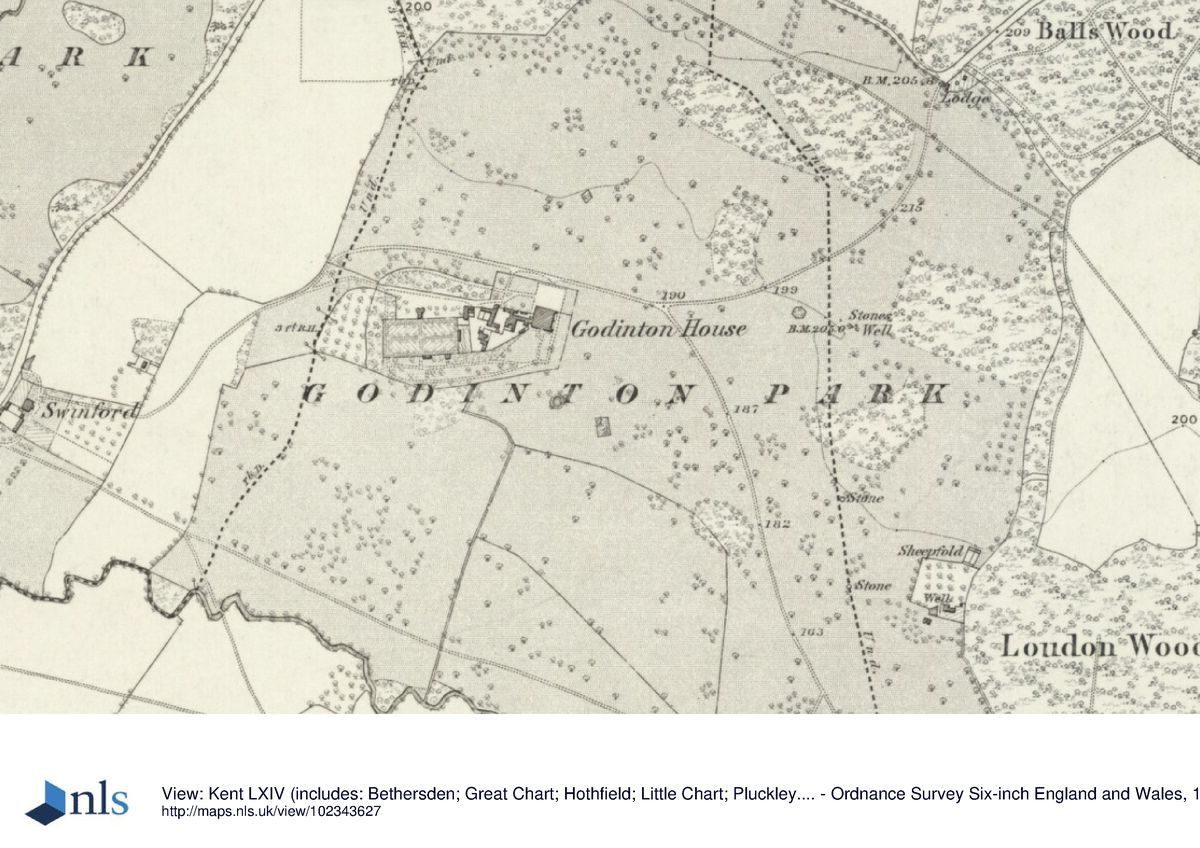
Godinton Park lies c 0.5km south-west of the A20, on the immediate north-west edge of Ashford. The 104ha registered site comprises 7ha of formal and ornamental gardens, surrounded by 97ha of parkland with several small woods and lies on the very gentle south-facing slopes of the Great Stour valley, the south side of which, beyond the site boundary, rises steeply to the village and church of Great Chart on the crest of the ridge. The site is set within a landscape of mixed pasture and arable farmland and woodland, with a minor lane running along part of the northern boundary and the Great Stour river forming the southern boundary. In the south-west the grounds of Swinford Manor School abut the site and to the south-east, screened only by narrow tree belts, tongues of housing from the western edge of Ashford.
Entrances and Approaches
The entrance to Godinton is from Godinton Lane to the north, at North Lodge, through gate piers hung with wrought-iron gates. The drive, shown established on this line by 1819-20 (Greenwood), follows a sweeping curve south and then westwards, passing along the north side of the forecourt to the house and continuing westwards towards West Lodge, which stands some 600m west of the house and outside the registered site boundary. The large, rectangular forecourt to the house, laid to an oval of gravel set in lawn and enclosed by tall, topiary yew hedges, is entered on its west side from the drive. An estate map of 1621 by Samuel Pierse shows the house approached from due north along a partly tree-lined drive. By 1769 (Andrews, Dury and Herbert), this entrance had been replaced by the approach from the north-east (although it followed a straight course at that time). A second drive (surviving now, 1998, as a track), laid out at the same time, runs southwards across the park towards Great Chart. Known as Chart Avenue (Wright 1989), its southern c 400m, approaching the railway bridge, are lined by a double avenue of grey poplars, replanted in the 1990s following storm damage in 1987 to replace the original trees planted c 1830-40 (ring counts and map evidence). A third drive, East Lodge drive (now, 1998, gone), was added as a branch off the southern drive between 1769 (Andrews, Dury and Herbert) and c 1818. East Lodge itself survives within C20 housing beyond the site boundary.
Principal Building
Godinton House (listed grade I) lies west of the centre of the park, on level ground. It comprises a large, red-brick, L-shaped house which was built in 1628 by Nicholas Toke around the core of a medieval courtyard house. Its main, east-facing façade is formed by a two-storey E-shape with attics shaped as Dutch gables and with a single-storey porch. The north, entrance front has similar gables above its projecting end window bays and above its central, two-storey porch. Additions were made to create the present plan, of a complete square with a tiny, enclosed courtyard, by John Toke in c 1760; further additions in the north-west corner in a matching style and materials were made by Sir Reginald Blomfield (1856-1942) for George Ashley Dodd in c 1896 (plans at Godinton). To the immediate west of the house stands a C17, red-brick courtyard block, entered from the drive beneath a high, round-headed carriage arch and comprising garages (former stables), Stable Cottage, Dairy Cottage, and Shepherd's Cottage (all listed grade II).
Gardens and Pleasure Grounds
The formal gardens, laid out as a series of compartments which include the north forecourt, surround the house to the north, east, and south in the form of a large rectangle, enclosed along its outer edge by a massive yew hedge with topiary buttresses and gables in a rhythmic sequence. This was planted by 1898 and is under restoration today (1997). The garden's structure of yew hedging, grass-banked terraces, paths and vistas, was designed and constructed by Sir Reginald Blomfield and completed by 1898. Blomfield's gardens, plans for which survive at Godinton, were laid out on the site of a series of C17 walled enclosures surrounded by orchards and fishponds, as recorded on Pierse's survey of 1621. These were removed and the garden landscape informalised in the late C18 by John Toke with the gardens ands shrubberies 'laid out by Driver' (Hasted 1790). Driver may have been Samuel Driver (d 1779), a nurseryman and landscape gardener (Harvey 1974) who also carried out work at Goodnestone in Kent (qv). The present ornamental planting of Blomfield's layout was largely begun in the 1950s by Mr Wyndham Green.
The east front opens onto a broad gravelled terrace walk, retained by a brick wall c 1m high (constructed in the 1950s to replace Blomfield's original grass bank) with flights of stone steps descending at the north and south ends onto the rectangular principal lawn. At the north end of the lawn a few steps lead up onto the Topiary Plat which is laid out with four box-hedge quarters, c 1m high, with pyramids at the corners and each enclosing a columnar cypress. A large statue of Pan, set on a circular stepped plinth, forms both the central feature of the plat and northern focus of the main north to south axis of the gardens. South of the principal lawn is a second lawn at a lower level, enclosed along the south side by a yew hedge and bisected by a broad, axial gravelled walk flanked by herbaceous borders laid out by Mr Wyndham Green. The walk terminates at a gap in the hedge and descends in a long flight of stone steps set within a steep grassed bank to the southernmost compartment which is laid out with a long, brick-rimmed oval pool, designed by Blomfield on the site of a former circular, parkland pond (OS 1876). The pool is surrounded by an inner enclosure of beech hedging and regularly spaced weeping willows (four survive (1997) from the six planted in the 1950s) and at the south end a statue of Venus, facing Pan, forms the southern focus of the north to south axis.
A gravelled walk extending south from the east terrace of the house forms a secondary north to south axis which runs parallel and to the west of the pool enclosure, beneath the remnants of a cherry and whitebeam avenue (planted 1950s). Its southern focus, 150m from the house, is a semicircular balustraded Prospect, designed by Blomfield, which breaks forward through the boundary yew hedge to give extensive views over the park and to Great Chart church on the skyline. The east terrace extends around the south front of the house where it overlooks a rectangular rose garden, laid out with triangular beds and enclosed with beech hedging to the east and south and with yew to the west. The present layout and the beech hedging dates from the 1950s; it is intended (1997) to restore Blomfield's original pattern of closely spaced square rose beds. South of the rose garden, grass banks on the north and west sides enclose a large open lawn, framed with shrubbery beds and, on the western edge, with a semicircle of clipped box and semi-mature fastigiate beech trees, formerly housing statuary.
Extending c 200m west of the formal gardens, and to the south of the kitchen garden, is the Wild Garden or Wilderness. Laid out with informal groups and scattered individual trees of mixed species and ages, and with two ponds sited towards the southern post and wire boundary, it was extensively replanted in the early 1990s after losses of c 75% of tree cover in the storm of 1987 (Storm Damage report, 1988). The eastern part of the Wilderness is shown occupied by an extensive pond system on an estate map of 1621 which by 1876 (OS) appears to have been replaced by informally planted deciduous and evergreen trees. The area of the Wilderness is shown extended to its present, fenced limits by 1907 (OS). North of the Wilderness and on the east side of the kitchen garden wall is a small, rectangular, walled Italian garden, built in the 1920s to designs produced by Blomfield in 1916 but considerably modified by Mrs Bruce Ward (Wright 1989). Entered on its south side through a colonnaded screen decorated with statuary and festooned with wisteria, its central feature is a cruciform pool backed at the north end by a raised, paved terrace covered by a timber pergola and with raised beds along the west and east walls. A doorway in a brick and pointed, pitched-roofed gazebo (C17, listed grade II), built against the west wall, leads into the kitchen garden.
Park
The parkland to the north and east of the gardens is laid to grazing and is enclosed on the boundaries by the mature woodland of Godinton Plantation and Balls Wood to the north (the core of the latter recorded as a square block on Pierse's 1621 survey) and by Chestnut Tell Plantation to the east. The parkland is abundantly scattered with individual mature trees and a few clumps, mainly oak but also horse and sweet chestnut, sycamore, lime, walnut, and a few conifers. Some 250m south of North Lodge, the land rises to form a knoll, known as the Chestnut Tell (shown on Pierse's survey) which is planted with several score of mature sweet chestnut trees over its slopes and summit. It is intended that the 60% of trees lost in the storm of 1987 be replanted. To the south of the formal gardens, as far as the boundary with the river, several fields are in arable cultivation and the pattern of parkland trees is much more sparse although a similar range of other species as in the northern parkland is mixed with the oaks.
Both Pierse's survey of 1621 (the terrier for which has not survived) and an estate account book with entries from 1616 to 1704 by Nicholas Toke and his nephew, confirm the existence of an early park at Godinton, centred around Pett's Hole (200m east of the house). By 1769, Andrews, Dury and Herbert's map shows the park greatly expanded to the west and south-east, with late C18 and early C19 views, such as that by John George Wood (c 1785-1800, published 1807), showing trees framing open vistas from the east front of the house across grazed pasture. According to Christopher Hussey (CL 1962), Samuel Driver, 'a follower of [Lancelot] Brown', also ' remodelled and replanted the whole park', although any work beyond the gardens is not confirmed by Hasted (1790). Little alteration occurred to the park through the C19, Greenwood describing it in 1838 as 'picturesque and well-wooded' and his survey of 1819-20 showing its boundaries very much as they are now (1997). Occasional park trees and five small park clumps were added to the tree cover during the C19, but the present general pattern of tree planting remains as shown on the 2nd edition OS map of 1898. Trees in the southern part of the park were more abundant then, diminishing to the present, 1997, scatter sometime after 1940 (OS).
Kitchen Garden
The kitchen garden, which also dates from the laying out of the gardens in the late C18 (it is shown on Mudge's map of Kent of 1801), lies c 70m to the west of the house. It is rectangular, 100m x 50m, and is enclosed by red-brick walls (listed grade II) with brick piers topped by ball finials marking the various gateways, several of which are filled with elaborate, white-painted timber screens. Two of the six or so late C19 greenhouses survive against the north wall which is pierced at its central point by a pair of brick oast houses with an attached bothy and potting shed (listed grade II), converted by Blomfield in 1907. The garden is quartered by grass paths and partly laid to fruit, vegetables, and cut flowers.
Other information
The parkland contains many fine trees including a magnificent group of ancient sweet chestnuts (Castanea sativa) reputed to be the tallest in Europe (Guiness Book of Records), an avenue of grey poplar (Poplus canescens) and good specimens of English and turkey oak (Quercus robur and Quercus cerris). The River Stour flows through the west sector of the estate where willows and alders create a picturesque landscape.
The most dramatic change has been due to the storm of October 1987. The most serious destruction was to the wilderness - the 18th century feature south-west of the walled garden - where 80% of trees have been destroyed. There had been commendable clearance by October 1988, especially of the garden area. The great sweet chestnut tree in the park has also been damaged. The grey poplar avenue (Populus canescens) across the railway line is also partially damaged. Most trees are standing, but the upper canopies have been destroyed or damaged. The avenue probably dates from the late 19th century.
The total character of the parkland is one of wooded enclosure, and despite the ever-encroaching housing estates to the south-west, the house and garden are remarkably secluded.
The plan shows the general layout and design of the garden essentially as Blomfield designed them. Outstanding mature trees of an earlier period included an English lime (Tilia europaea) (unfortunately felled in 1987 due to decay) and a London plane (Platanus hispanica), south-west of the house, and various hardwood species in the wilderness.
Maps
- Samuel Pierse, Estate map, 1621 (Centre for Kentish Studies, Maidstone)
- J Andrews, A Dury and W Herbert, A Topographical Map of the County of Kent ..., 2" to 1 mile, 1769
- W Mudge, Map of Kent, 1" to 1 mile, 1801
- C Greenwood, Map of the County of Kent from an actual survey made in the years 1819 and 1820, about 1" to 1 mile, 1821
- OS 6" to 1 mile: 1st edition surveyed 1871, published 1876; 2nd edition surveyed 1896, published 1898; 3rd edition published 1908; 1940 edition
- OS 25" to 1 mile: 1st edition surveyed 1871, published 1876; 3rd edition published 1907; 1947 edition
Illustrations
- John George Wood, View of Godinton, about 1785-1800 (in Wood 1807)
Archival items
- Toke Family Papers (U967), (Centre for Kentish Studies, Maidstone)
- Godinton House archives (private collection)
Description written: September 1997
Amended: June 1999, February 2023
Edited: October 2003
- Visitor Access, Directions & Contacts
Website
https://godintonhouse.co.ukAccess contact details
The gardens are open daily between March and October. For more detailed information visit the Godinton House website.
Directions
The site is half a mile north-west of Ashford off the A20.
- History
17th Century
The site has a 17th-century red brick gabled house, with an earlier core. It was owned for several centuries by the Toke family. Few records of the contemporary parkland or estate survive but it is known that a certain Mr Driver was employed in the late-18th century to ‘improve the park' in the taste of the period by laying out shrubberies and creating a wilderness that still survives to the south-west of the house.
19th - 20th Century
The Arkley Dodd family purchased Godinton in 1896 and in 1902 called in the architect and garden architect Reginald Blomfield to renovate the house, and design a new garden around it. He enclosed an area of some 10-12 acres with yew hedges and created a simple, formal garden within this boundary, using axial lines to link a formal topiary garden with a long pool and tree lined walks.
He also converted an existing oast house into a remarkably modern looking bothy and potting shed beside the walled kitchen garden. His proposed plans for the Italian garden (see plan shown in T Wright's study of Kent gardens) adjoining the walled garden were modified and constructed in the early 1920s by the present owner's grandmother. Some alterations and softening of Blomfield's design have been made over the years.
The following is from the Register of Parks and Gardens of Special Historic Interest. For the most up-to-date Register entry, please visit The National Heritage List for England (NHLE):
The manor of Godinton was held variously by the de Godinton, Champneys, and Goldwell families before passing through marriage to Thomas Toke in the late 15th century. It remained in the Toke family until 1896 when Colonel John Leslie Toke sold the estate to Mr George Ashley Dodd. He extended the house and laid out the present formal gardens before selling Godinton to Mrs Bruce Ward in 1919. Her grandson, Mr Alan Wyndham Green, inherited in 1953 and on his death in 1995 the ownership and management of the estate passed into the hands of the present (1997) Godinton House Preservation Trust.
Period
18th Century (1701 to 1800)
- Associated People
- Features & Designations
Designations
The National Heritage List for England: Register of Parks and Gardens
- Reference: GD1048
- Grade: II*
Features
- Pond
- Topiary
- Terrace
- Herbaceous Border
- Tennis Lawn
- Lawn
- Walk
- Specimen Tree
- Description: A magnificent group of ancient sweet chestnuts (Castanea saliva) reputed to be the tallest in Europe.
- House (featured building)
- Description: The site has a 17th-century red brick gabled house, with an earlier core.
- Earliest Date:
- Latest Date:
- Shrubbery
- Earliest Date:
- Latest Date:
- Wilderness
- Description: A Mr. Driver created a wilderness area to the south-west of the house. This still survives, though it was damaged in the 1987 storm.
- Earliest Date:
- Latest Date:
- Tree Avenue
- Description: An avenue of grey poplar (Poplus canescens).
- River
- Description: The River Stour flows through the west sector of the estate where willows and alders create a picturesque landscape.
- Kitchen Garden
- Description: Dates from the laying out of the gardens in the late C18. It is rectangular, 100m x 50m, and is enclosed by red-brick walls (listed grade II) with brick piers topped by ball finials.
- Oast house (or Hop Kiln)
- Description: Brick oast houses with an attached bothy and potting shed (listed grade II).
- Gardens
- Parkland
- Key Information
Type
Estate
Purpose
Ornamental
Principal Building
Domestic / Residential
Period
18th Century (1701 to 1800)
Survival
Extant
Hectares
105
Open to the public
Yes
Civil Parish
Great Chart with
- References
References
- {English Heritage Register of Parks and Gardens of Special Historic Interest}, (Swindon: English Heritage, 2008) [on CD-ROM] Historic England Register of Parks and Gardens of Special Historic Interest
- Wright, Tom {The Gardens of Britain 4: Kent, East & West Sussex and Surrey}(London: Batsford, 1978) The Gardens of Britain 4: Kent, East & West Sussex and Surrey
- Kent County Council Planning Department {The Kent Gardens Compendium} (Canterbury: Kent County Council, 1996) 62 The Kent Gardens Compendium
- Oswald, Arthur {Country Houses of Kent} (London: Country Life, 1933) Country Houses of Kent
- Hasted, E., (1797-1801) [Facsimile edition 1972] ‘Parishes: Speldhurst', The History and Topographical Survey of the County of Kent: Volume 3
- Greenwood, C., volume 1, County of Kent (1838) An Epitome of County History
- Lodge, E. C., (editor), (1927) The Account Book of a Kentish Estate 1616-1704
- Newman, J., (1969), pp 295-7 The Buildings of England: West Kent and The Weald
- Harvey, John., (1974) Early Nurserymen
- Wright, T., (unpublished report 1989) Godinton Park, Kent, Outline Proposals and Aims of Restoration
- (Colvin and Moggridge May 2000) Godinton Park, Review of History and Restoration and Management Plan
- (11 May 1907), pp 666-73; 132 (6 December 1962), pp 1396-9; (13 December 1962), pp 1546-9; (20 December 1962), pp 1600-03 Country Life, 21
Contributors
Kent Gardens Trust
- Related Documents
-
CLS 1/303/1
Review of History and Restoration Management Plan - Digital copy
Colvin and Moggridge - 2000
-
CLS 1/303/1