Introduction
Encombe is an 18th-century landscape park with lakes, woodland and agricultural land. The central area of gardens surrounding the house is about 8 hectares.
Terrain
The site is undulating, with high ground to the north dropping away southwards to the sea. The park comprises a bowl with ridges of high ground encircling it to the north and north west.
The following is from the Register of Parks and Gardens of Special Historic Interest. For the most up-to-date Register entry, please visit The National Heritage List for England (NHLE):
An 18th century park with an extensive circuit of carriage rides, together with 18th century pleasure grounds, laid out with the advice of William Pitt, Earl of Chatham, and later elements designed by George Repton.
Location, Area, Boundaries, Landform and Setting
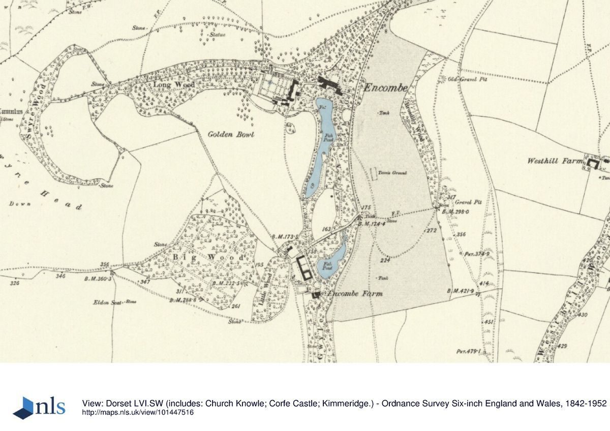
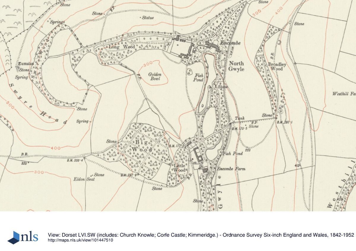
Encombe is situated c 1km south west of Kingston and c 1.3km north of the coast at Freshwater Steps. The c 326ha site is adjoined to the north, east, and west by agricultural land, while to the south the boundary is formed by the coastal cliffs. The site is undulating, with high ground to the north dropping away southwards to the sea. The park comprises a bowl with ridges of high ground encircling it to the north and north west at Swyre Head, and to the east. A stream flows through a valley which extends south from the House to the coast, while a cone shaped hill, the Golden Bowl, rises to the south west of the House. The site also includes the rocky headland at Egmont Point, from which there are views of Chapman's Pool, a cove c 1.5km south east of the House.
There are extensive views from the higher ground within the site across the park and towards the sea, while a southerly view from the House, across the lake to the sea provides the illusion that the lake and sea merge. To the north east the site adjoins the estate village of Kingston, while to the west, Encombe is contiguous with the Smedmore estate which had been the subject of landscape improvement by its owner, George Clavell, in the mid C18; both contribute to the setting of the site.
Entrances and Approaches
Encombe is approached from the B3069, Kingston Hill to the north east. The entrance is marked by a pair of mid C19 stone piers under stepped caps flanked by low stone quadrant walls (listed grade II), and Lynch Lodge (listed grade II), a single storey Gothic style stone structure built in 1864. Beyond the entrance, a gravel drive leads c 670m south west through a belt of plantation and a widely spaced avenue, before turning south to cross a minor road which leads west from Kingston. This road continues c 950m west and south west to reach the London Door Gate, and affords extensive northerly views towards Corfe Castle.
From the junction with the minor road, the principal drive, now tarmac, continues c 300m south through The Plantation, before turning west to descend a steep south facing wooded hillside, Quarry Wood, and joining the north drive which descends from the London Door entrance, which is marked by rusticated stone piers. The drive sweeps south east and south west, passing below the western boundary of Quarry Wood, and to the east of a shoulder of high ground on which stands a mid C 19 obelisk. Continuing c 270m south west, the drive arrives at a junction c 270m north east of the House, from which one drive leads directly to the carriage turn below the north facade of the House, a second drive leads west south west to the stables, and a third extends south south west to pass along the east side of the pleasure grounds to provide access to Encombe Farm c 550m south of the House.
The early C19 stables (listed grade II) c 100m south west of the House and immediately east of the walled garden are constructed in ashlar, with a central stable range surmounted by a pediment and bell turret flanked by a pair of projecting wings comprising cottages. The present stables were constructed for the second Earl of Eldon on the site of the mid C18 stables built by John Pitt and shown on the estate plan of c 1806.
The principal drive appears to have assumed its present form in the late C19, presumably in connection with Salvin's scheme for transferring the entrance to the House to the north facade. The approach made use of existing drives forming part of the C18 circuit of carriage drives shown on Isaac Taylor's Map of Dorset (1765), to which the section of drive leading through The Plantation to Lynch Lodge was added.
The c 1806 estate plan and the Tithe map (1834) record the C18 approach to the House, with a drive passing at a high level along the east side of Quarry Wood and continuing south to turn round the south east end of Broadley Wood. From this point the drive turned west, dropping down into the valley and crossing the stream below the north lake and continuing to pass to the north of Encombe Farm. Taylor's map (1765) shows a spur leading north from this point, outside the eastern boundary of the pleasure grounds, to reach the House. A further drive led north from a point immediately north of the Farm, passing to the west of the lake and approaching the stables from the south.
From the stables a drive led east to a circular carriage turn below the south facade of the House; a further drive led south east from the carriage turn to emerge into the park. A drive, corresponding to the surviving north drive, is shown leading north from the stables along the west side of pleasure grounds, north of the House and west of Quarry Wood. Ascending eastwards through the wood, the drive rejoined the eastern approach at the north east corner of Quarry Wood. With the exception of those portions of the C18 drive which remain in use today, the circuit survives as tracks within the park and plantations. The London Door entrance does not appear on the Tithe map (1834).
Principal Building
Encombe House (listed grade II*) is a long, low structure which stands towards the centre of the site at the head of a valley falling away south to the coast. The House comprises two storeys and an attic, and is constructed in ashlar under hipped slate roofs. The south facade, the garden facade since 1871 but constructed as the entrance front, has a recessed central section flanked by projecting wings. The central ground floor window, formerly the front door, is framed by Tuscan columns and an entablature. Above, a raised pedimented dormer rises from the parapet. This centrepiece is flanked at ground floor level by two five bay colonnades (now glazed) supported by Tuscan columns. The north facade, now the entrance front, is symmetrical in plan with a projecting central range flanked by slightly recessed wings. The door at the centre of the facade is surmounted by a pediment supported on Tuscan columns, which was relocated from John Pitt's Dairy in 1959.
Encombe House was originally constructed by John Pitt to his own design from 1735. This building incorporated elements of an existing house, and in plan had a central rectangular block flanked by four wings extending from each corner of the principal block (RCHME 1970). This building was altered in the 1870s by Anthony Salvin, who turned the House round and regularised the north facade.
Gardens and Pleasure Grounds
The informal pleasure grounds are situated principally to the south of the House, with a further area of informal shrubbery and pleasure ground to the north.
An area of level lawn extends below the south facade of the House, corresponding to the site of the C 18 carriage turn which comprised a circular lawn, later converted into a parterre (Estate plan, c 1806; OS 1891). To the west and south west of the House the ground rises, while shrubberies and specimen trees serve to screen the stables. Some 80m south west of the House, a temple (listed grade II) stands at the top of the slope, looking south east towards the lake. The temple is approached by a flight of stone steps and is constructed in stucco and ashlar with an eastern pediment supported by Tuscan columns. A pediment on the west facade of the temple, facing the stables, is supported by Ionic columns. The temple was constructed in the early C 19 by the first or second Earl of Eldon. A level terrace to the north of the temple incorporates a C20 swimming pool.
A sinuous lake extends c 350m south from the south lawn, with a C19 stone tazza fountain towards its northern end. A mid C19 narrow, stepped stone cascade feeds the lake c 100m south south east of the House, while a C 19 stone boathouse is constructed on the west side of the lake c 220m south of the House. A wide mown grass walk leads south east from the south lawn, following the eastern bank of the lake. To the east of this walk a belt of mixed shrubbery and specimen trees screens the boundary of the pleasure grounds, while c 220m south south east of the House, a pair of C 18 stone piers surmounted by vase finials (listed grade II) supports a pair of simple iron gates which led to the eastern circuit of C 18 carriage drives.
The south east bank of the lake is an artificial embankment or dam retaining the water, and from this point a walk descends into the valley and continues c 200m south southeast through an area of mixed shrubbery and specimen trees, to reach the Rock Bridge (listed grade II), which carries the east drive over the pleasure ground walk. The bridge forms a grotto constructed from Cyclopean rockwork with three linked tunnels leading beneath the drive to emerge above the lower valley or South Gwyle. A rocky recess in the southern face of the Rock Bridge would formerly have afforded views (now, 2004, obscured by vegetation) across the lower lake and down the valley towards the sea. The Rock Bridge formed part of John Pitt's C18 landscape and was a significant picturesque incident on the circuit of walks and drives through the estate.
The lower lake is irregular in form, and lies immediately east of Encombe Farm, which in its original form would also have served as an incident on the tour of the estate, and which incorporated John Pitt's ornamental dairy (demolished 1959). Below the lower lake, the South Gwyle valley is now (2004) largely covered by impenetrable vegetation. The c 1806 estate plan, the Tithe map (1834), and the OS map of 1891 all indicate that floor of the valley was formerly more open, with a walk passing along its western side, while a carriage drive ran parallel to the eastern boundary of the valley, entering the pleasure grounds c 350m south of Encombe Farm, crossing the valley and passing into the western park c l 00m north of Freshwater Steps. A stream, broken by a series of cascades, flowed through the valley, while a circular summerhouse stood c 350m south of the Farm; it is not known whether any remains of this structure survive. The stream emerges from the southern end of the valley in a cascade descending to the sea. From this point a walk extended eastwards along the coast to the Rock House, a summerhouse standing on Egmont Point affording views west along the coast, and east to Chapman's Pool.
From Encombe Farm, a track corresponding to the southern end of the C18 carriage drive leading to the House, leads north for c 160m, passing to the west of an approximately elliptical shaped glade which is shown on the c 1806 estate plan, and which is named on the Tithe map (1834) as the `Horse Plot'. Passing through a gateway into the pleasure grounds, a mown grass walk extends along the west side of the upper lake, passing the boathouse and emerging at the south west corner of the south lawn. The walk is screened from the western park by a narrow strip of C20 trees. The estate plan (c 1806) and the Tithe map (1834) show that the ground to the west of the lake and the Horse Plot formed part of the park, with the boundary of the pleasure grounds being c 120m south west of the House. By 1886 (OS 1891) the present arrangement had been established.
To the north of the House an area of mixed shrubbery and specimen trees adjoins the drive and carriage turn. The estate plan (c 1806) shows a triangular shaped area of pleasure grounds north of the House, with a complex layout of paths and allies. A semicircular lawn below the north front of the House led to a straight vista, which in turn gave access to a broad allée extending parallel to the western boundary of the pleasure ground. To the east, concealed with shrubbery and approached by winding paths, an elliptical pool lay to the south of an elliptical lawn which was similarly enclosed by shrubbery. A semicircular exedra at the northern end of the pleasure ground led to a serpentine walk passing through a triangularshaped plantation, and thence to the park. The northern pleasure grounds are recorded in a simplified form on the Tithe map (1834). The north lawn, shrubberies, serpentine walks and the elliptical pool are shown, but the lawn north of the pool had been planted out. By the late C19, the pleasure ground had been modified into its present form (OS 1891).
Park
The park lies to the north, west, and east of the pleasure grounds, and today (2004) remains predominantly undulating downland pasture with ornamental clumps and plantations. There are very few specimen parkland trees, while the area to the south east of the House and pleasure grounds, and to the south of Big Wood, is in arable cultivation. To the north of the House, the park rises in a shoulder of high ground, North Hill, on which stands a stone obelisk (listed grade II) erected by Lord Eldon in 1835 to commemorate the ennobling of his elder brother, Sir William Scott, as Baron Stowell (inscription). The obelisk serves as an eyecatcher from many points within the park.
The high ground sweeps round the north and north west sides of the park to reach Swyre Head, c 850m south west of the House. These boundaries of the park are enclosed by belts of woodland, The Belt and Polar Wood, which connect Quarry Wood north east of the House with Swyre Wood to the south west. A grass track extending below and to the south of the boundary plantations corresponds to an C18 carriage drive constructed by John Pitt, and described in 1836 by Lord Eldon's niece as `the beautiful grassy terrace, on the high ground that surrounds the bowl [of the park]' (House Historians). The drive affords wide views to the south and south east across the park, House, and pleasure grounds towards the sea.
On the lower ground, below the drive, Long Wood extends westwards from the kitchen garden, and is separated from Big Wood and Little Wood to the south by the conical Golden Bowl. Some 190m south west of Big Wood, Eldon's Seat comprises a simple seat formed from two massive blocks of stone affording panoramic views of the park and coast to the south and south east. The seat was constructed in 1835 to the design of G S Repton (House Historians). Isaac Taylor's Map of Dorset (1765) shows the carriage drive continuing round the bluff of Swyre Head, and turning west through the park towards Smedmore, before turning south and east to return along the southern boundary of the park above the cliffs. It then ran along the west side of the pleasure grounds in South Gwyle to reach Encombe Farm. This south west section of John Pitt's carriage drive does not survive today (2004) and is partly outside the registered site, although some footpaths and tracks may correspond to parts of the circuit.
The park to the east and south east of the House comprises a steep west facing slope terminated to the south by Houns tout Cliff and Egmont Bight. A shoulder of high ground immediately east of the House is emphasised by Broadley Wood. A level grass track extends south from The Plantation, parallel to the eastern boundary of the site, to reach the cliffs. This corresponds to another C18 carriage drive shown on Taylor's map (1765). The southern section of the drive appears to have been lost to cliff falls, but formerly looped south east to join a surviving track (outside the registered site). This drive led north to a junction from which one route led north, passing to the east of Westhill Wood and thence to Kingston, while another route led east and north east through Hill Bottom (Taylor, 1765).
The park appears to have been developed in essentially its present form in the mid and late C18 under John Pitt, with advice from William Pitt, Lord Chatham. The layout found on the Tithe map (1834) and the OS map of 1891 differs little from that recorded on the early C19 estate map (c 1806). The circuit of carriage drives initially developed by John Pitt was altered in the early and mid C19 by the first and second Earls of Eldon, in part to compensate for coastal erosion (Hutchins 1861).
Kitchen Garden
The kitchen garden is situated c 80m west of the House and immediately west of the stable block. The garden is approximately square on plan, and is enclosed by brick walls c 3m high surmounted by stone and brick coping (listed grade II). A narrow walled slip extends along the southern side of the main compartment, while a larger walled slip to the north of the main compartment is approached by a flight of steps. Today (2004) the garden is largely laid to grass and is not in cultivation. The remnants of C19 or C20 glasshouses survive in the northern slip, while evidence of further glasshouses, corresponding to those shown on the OS map of 1901, remains against the northern wall of the principal compartment.
The kitchen garden assumed its present form in the early C19 when the C18 stables were rebuilt by the second Earl of Eldon (succeeded 1838). The garden occupies the site of a formal garden, perhaps a productive garden or a flower garden, shown immediately west of the C18 stables on the c 1806 estate plan and the Tithe map (1834). These maps mark an approximately square area west of this formal garden as kitchen garden, with a rectangular pool or canal extending from east to west. A rectangular extension to the north west of this garden corresponds to an orchard shown on the Tithe map (1834) and the late C19 OS map (1891). The layout recorded on the c 1806 plan and the Tithe map represent John Pitt's mid or late C18 kitchen garden and orchard.
The kitchen garden is adjoined to the west by Long Wood, today (2004) a mixed plantation filling a gently sloping valley north east of Swyre Head. The c 1806 estate plan indicates that this plantation was laid out with a series of serpentine walks leading to a circular glade with a central specimen tree towards the western end of the wood, and thence to Swyre Head. Within the plantation, an approximately parallelogram shaped enclosure with a building at its south west corner is marked as the `Vineyard'. This feature is not recorded on the Tithe map (1834), but the path pattern shown within the wood on the late C 19 OS map (1891) appears to correspond closely to that shown on the early C19 estate plan (c 1806). The features recorded on the early C19 plan and the Tithe map represent John Pitt's treatment of Long Wood.
REFERENCES
J P Neale, Views,2 (iv) (1828)
J Hutchins, History of Dorset (3rd edn 1861), pp 515-522
A Oswald, Country Houses of Dorset (2nd edn 1959), pp 155-156
Country Life 133, (24 January 1963), pp 164-167; (31 January 1963), pp 214-217 Royal Commission on Historical Monuments (England), An Inventory of Historical Monuments in the County of Dorset II, part 1(1970), pp 78-81
N Pevsner and J Newman, The Buildings of England: Dorset (1972), pp 200-201
Garden History 24, no 1 (1996), pp 126-136
T Mowl, Historic Gardens of Dorset (2003), pp 81-82
The House Historians, A Historical Report of the South Front at Encombe Dorset (nd)
The House Historians, A Historical Report on the Carriage Drives at Encombe (nd)
Maps
- I Taylor, Map of Dorset, 1765
- Plan of Encombe, c 1806 (D/SEN 3/10/9), (Dorset Record Office)
- J Martin, Tithe map for Corfe Castle parish, 1834 (PE/COC/SD 1, 2), (Dorset Record Office)
- OS 6" to 1 mile: 1 st edition surveyed 1886, published 1891
- 2nd edition revised 1900, published 1902
- 1929 edition
- OS 25" to 1 mile: 2nd edition revised 1900, published 1901
Illustrations
- Encombe in Dorsetshire a Seat of John Pitt Esq, engraved view from the south (published in Hutchins 1861)
- J P Neale, Encombe House, engraved view from the south west (published in Neale 1828)
- Early C19 drawings of Encombe (private collection)
Archival items
- The Scott family archive, including plans and items acquired from Pitt family on purchase of Encombe, is held at the Dorset Record Office (D/SEN).
- J Pouncey, mid C19 photographs of Encombe (private collection)
Description written: November 2004
Amended: December 2004
Edited: May 2005
- Visitor Access, Directions & Contacts
Telephone
01372 384045
- History
The following is from the Register of Parks and Gardens of Special Historic Interest. For the most up-to-date Register entry, please visit the The National Heritage List for England (NHLE):
www.historicengland.org.uk/listing/the-list
HISTORIC INTEREST
During the medieval period, Encombe formed part of the estates of Shaftesbury Abbey. In 1552 the estate was acquired by Robert Culliford, with whose descendants it remained until 1734, when William Culliford obtained an Act of Parliament to sell the property in order to settle his debts (Oswald 1959). Encombe was purchased by George Pitt (d 1735) of Stratfield Saye, Hampshire and Kingston Maurward, Dorset, who settled it on his second son, John. John Pitt, second cousin of William Pitt the Elder, Prime Minister and first Earl of Chatham (1708-1778), was an able amateur architect who, in 1735, began to build a new house, incorporating elements of an existing building (RCHME 1970). Pitt, whose later works included the Rotunda at Hagley, Worcestershire, incorporated into his house, which was completed in about 1770, elements of design derived from Vanbrugh and Hawksmoor, and also from Palladio. An extensive park was formed, with a circuit of carriage drives allowing a succession of views and incidents, including a cascade on the coast, a picturesque grotto, and a lake south of the house. The effect of these improvements is shown in an engraving of about 1774 (Hutchins 1861). In the development of the landscape, John Pitt was advised by his cousin, William Pitt, Earl of Chatham, who was a frequent visitor to Encombe (Garden Hist 1996), and who, with Lancelot Brown, laid out his own estate at Burton Pynsent, Somerset, and advised on the development of his friends' landscapes at Hagley, Worcestershire, Stowe, Buckinghamshire, and Stoke Park, Avon.
John Pitt inherited Kingston Maurward from his elder brother in 1774, and died in 1787, at which time Encombe passed to his son, William Morton Pitt. An estate map of 1794 indicates that William Morton Pitt extended the park by taking in former agricultural land, while a further map of about 1806 shows the combined effect of W M Pitt's development of his father's landscape. In 1806, Pitt sold Encombe to John Scott (created Baron Eldon, 1799 and Earl of Eldon, 1821), Lord Chancellor in William Pitt the Younger's Administration. Lord Eldon's elder daughter eloped with George Repton (1786-1858), son of Humphry Repton, and following a reconciliation, George Repton was commissioned by his father-in-law to make improvements to the estate village, Kingston, and to the grounds at Encombe (Country Life 1963). Lord Eldon died in 1838 and was succeeded by his son. The second Earl obtained a plan from George Repton for remodelling the north front of the house in 1841, but this remained unexecuted. The third Earl, who succeeded in 1854, instead commissioned Anthony Salvin (1799-1880) in about 1870 to remodel the house. Salvin transferred the entrance from the south to the north front, which in turn led to an alteration in the circuit of drives within the park.
When the third Earl died in 1926, Encombe passed to his younger son, Sir Ernest Scott, who in turn left it to his nephew, Colonel Harold Scott, in 1953. The estate was sold in 2002, and today (2004) remains in private ownership.
Period
18th Century (1701 to 1800)
- Associated People
- Features & Designations
Designations
The National Heritage List for England: Register of Parks and Gardens
- Reference: GD1397
- Grade: II*
Features
- Lake
- House (featured building)
- Description: The house was re-modelled in around 1870.
- Earliest Date:
- Latest Date:
- Parkland
- Woodland
- Gardens
- Key Information
Type
Estate
Purpose
Ornamental
Principal Building
Domestic / Residential
Period
18th Century (1701 to 1800)
Survival
Extant
Hectares
368
Open to the public
Yes
Civil Parish
Corfe Castle
- References
References
- Newman, J and Pevsner, N {The Buildings of England: Dorset} (Harmondsworth: Penguin, 1972) pp 200-201 The Buildings of England: Dorset
- Mowl, Timothy {Historic Gardens of Dorset} (Stroud: Tempus, 2003) pp 81-82 Historic Gardens of Dorset
- Oswald, A {Country Houses of Dorset} (2nd edn 1959) pp 155-156 Country Houses of Dorset
- {English Heritage Register of Parks and Gardens of Special Historic Interest} (Swindon: English Heritage 2008) [on CD-ROM] Historic England Register of Parks and Gardens of Special Historic Interest
- Related Documents
-
CLS 1/248/2
Restoration Plan for the Historic Landscape of Encombe, Dorset Part 1 The Report - Hard copy
Debois Landscape Survey Group - 2005
-
CLS 1/248/3
Restoration Plan for the Historic Landscape of Encombe, Dorset Part 2 The Appendices - Hard copy
Debois Landscape Survey Group - 2005
-
CLS 1/248/2