Introduction
Creech Grange has mid-18th-century gardens, and a landscape of about 135 hectares which retains some formal characteristics. The lakes and woodland were developed in the 19th century. The estate has been in divided ownership since 1979, with a central area of around 23 hectares.
Terrain
The site slopes steeply from south to north, with the north-facing escarpment of the Purbeck Hills being covered by Great Wood. The ground around the house is level, while to the west a valley drops away towards Little Wood.The following is from the Register of Parks and Gardens of Special Historic Interest. For the most up-to-date Register entry, please visit The National Heritage List for England (NHLE):
Gardens and parkland associated with a country house, which retain elements of an early and mid C18 layout, together with C19 improvements.
Location, Area, Boundaries, Landform and Setting
Creech Grange is situated c 5km south-south-west of Wareham and c 1.5km north of the village of Steeple, beneath the north-facing slope of the Purbeck Hills. The c 135ha site comprises some 12ha of gardens and pleasure grounds, c 58ha of parkland, and c 48ha of ornamental plantation known as Great Wood, which formed part of the early-C18 landscape. It also includes approximately 18ha of C19 plantations to the north. The site is adjoined to the west by areas of woodland, and to the north and east by agricultural land. To the south the site is bounded by open downland on the ridge of the Purbeck Hills. The site slopes steeply from south to north, with the north-facing escarpment of the Purbeck Hills being covered by Great Wood. The ground continues to slope northwards below the wood to a minor road which leads west from Creech to East Lulworth, and which passes c 50m south of the house. The ground around the house is level, while to the west a valley drops away towards Little Wood. There are extensive northerly views across heathland north of the site from Grange Arch on the summit of Grange Hill, and from walks within Great Wood.
Entrances and Approaches
Creech Grange is approached from a minor road to the north-east, at a point opposite the junction of that road and another minor road which leads east to East Creech. A straight drive extends west-south-west from the entrance for c 130m to reach the carriage court below the east facade of the house. The court is enclosed to the north and south by C18 brick walls with stone coping (listed Grade II). The north wall is partly screened by yews and evergreen shrubbery, while the centre of the court is filled by an elliptical lawn. To the north-west and south-west of the court, wrought-iron gates supported by rusticated stone piers under ball finials (listed Grade II) lead respectively to the stable yard and service court north of the house, and to a gravel walk extending beneath the south facade of the house.
The east drive remains essentially unchanged from the approach shown on the mid-C18 estate plan and the late-C19 OS map (1888).
Principal Building
Creech Grange (listed Grade I) stands on an artificially levelled terrace towards the centre of its park. The house is constructed in ashlar under stone slate roofs and comprises two storeys and an attic. The east or entrance facade is Tudor-gothic in style and has a full-height projecting central porch and projecting gabled wings at each end of the facade. The facade is lit by mullioned windows, while the south-east wing is lit by a C16 oriel window. The east facade was rebuilt in its present form by the Rev Nathaniel Bond in 1846.
The south facade is classical in style and comprises seven bays, with a projecting central section beneath a pediment. The corners of the central section and the outer corners of the facade are articulated by rusticated quoins, while the facade is surmounted by a balustraded parapet. A central, part-glazed door is flanked by Tuscan pilasters and surmounted by an entablature, and the facade is lit by sash windows. The south elevation was constructed in 1738-41 for Denis Bond who employed Francis Cartwright of Blandford Forum as his architect.
The service ranges to the north of the house are constructed in rubble stone and were built at various dates.
Gardens and Pleasure Grounds
A formal lawn extends to the south of the house, while formal gardens leading to an extensive area of informal pleasure grounds lie to the west of the building.
The south lawn is approximately square on plan and is bounded to the north by a gravel terrace extending beneath the south facade of the house. Further tree-lined gravel walks delineate the east and west sides of the lawn, while to the south it is enclosed by a ha-ha and hedge separating it from the minor road leading west to East Lulworth. The south lawn corresponds to a lawn shown on the mid C18 plan; it is not known whether the octagonal fountain basin shown in the centre of this lawn on the plan was constructed. An area of trees and shrubbery to the west of the lawn, and a similar area, The Rookery, to the east of the lawn appear to correspond to two groves with radiating walks shown on the mid C18 plan. The walks do not survive in the form shown on the plan.
To the west of the house there is an area of level lawn affording views across the park, while to the west-north-west a rectangular sunken lawn is approached by stone steps at its south-east and north-east corners. The lawn is laid out as a formal garden with geometrical flower beds and a circular fountain basin. Beyond the formal garden, at a slightly lower level and on the same axis, a rectangular canal extends c 130m west-north-west towards Little Wood. The banks of the canal are planted with specimen trees and shrubs, while mown grass walks extend along its northern and southern banks. At its western end, adjacent to the remains of a statue, the canal discharges over a cascade into the first of a series of three irregular-shaped ponds which extend north-west through the informal pleasure grounds in Little Wood. The ponds are linked by further cascades, while a network of serpentine walks connects a series of straight formal glades cut through the woodland. The remains of a temple or other garden building survive at the intersection of the principal north to south and south-west to north-east glades c 360m west of the house.
A walk passing along the north side of the sunken lawn west-north-west of the house turns north-north-west through the pleasure grounds to reach the chapel of St John the Evangelist (listed Grade II*) which stands in a walled enclosure planted with mature Lebanon cedars and other conifers. The chapel was built by Denis Bond in 1746 and incorporates a C12 chancel arch removed by Bond from East Holme Priory, or Bindon Abbey (both Dorset), and appears to have been intended to serve as a feature in his landscape scheme. The chapel was rebuilt by the Rev Nathaniel Bond in the mid C19.
The formal gardens and informal pleasure grounds in Little Wood are not delineated on the mid C18 plan, but appear to have been developed by Denis Bond c 1740. The formal gardens remain little changed from their appearance in early C20 photographs. The pleasure grounds were altered in the C19 with the introduction of specimen trees and ornamental shrubbery, and by the late C20 these areas had become overgrown and neglected. A conservation programme has been implemented since 1979.
Park
The park lies principally to the north, south and south-east of Creech Grange and remains (2009) predominantly pasture with scattered trees. The park is crossed from east to west by the minor road running from Creech to East Lulworth, and from north to south-south-west by the minor road running from Creech to Tyneham. These roads converge c 190m south-east of the house, while a third road extends parallel to the northern boundary of the park from the entrance to Creech Grange to East Creech. To the north-west the park is bounded by Great Plantation and Louisa's Firs while to the south it is bounded by Great Wood which clothes the north-facing escarpment of the Purbeck Hills.
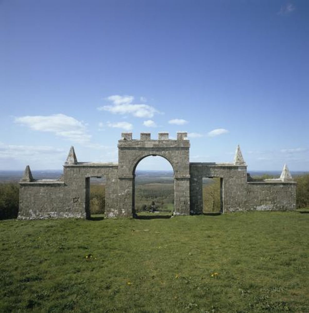
To the south of the house, and on an axis with it, blocks of planting and a pair of stone urns set on pedestals frame the northern end of a vista cut through Great Wood to Creech Arch which stands on the crest of the escarpment c 500m south-south-east of the house. Creech Arch (listed Grade II*) is constructed in ashlar and comprises a central arched opening surmounted by crenellations, which is flanked by lower wing walls in which are set square-headed openings. These are in turn flanked by lower wing walls, and the changes in height are marked by pyramidal finials. The arch was constructed by Denis Bond before 1746 to serve as an eyecatcher from the Grange. The southern vista is delineated on the mid-C18 garden plan with a circular lawn leading to three radiating glades, the central one aligned on a single arch and the other two aligned on pyramids or squat obelisks. It is unclear whether this scheme was ever realised, and the radiating glades are not shown on the 1888 OS map.
A series of contoured walks extends through Great Wood, allowing views across Creech Grange and its park and across the level heathland in the valley of the River Frome to the north of the site. The parkland to the north of the house is framed by the mid- and late-C19 plantations, Great Plantation and Louisa's Firs, and is ornamented with individual trees, particularly along the watercourse that runs west - east, and by tree planting on the knoll of Carrot Bank and a small triangular plantation of oaks to the south. The approach road from Wareham to the north east which was straightened sometime between 1765 and 1805 provides a sequence of views across the parkland with the Chapel of St John the Evangelist to the south west acting as a landscape feature. At the northern edge of Great Plantation is Drinking Barrow, a prehistoric burial mound (scheduled monument, SM 28309) that was planted with a clump of fir and pine, probably during the first half of the C18. It is considered that it provided a key focal point in the landscape and it aligns with one of the main vistas in Little Wood to the south.
Kitchen Garden
The kitchen garden is situated c 20m north-west of the house and immediately north-west of the stables and service yard. Approximately parallelogram-shaped on plan, the garden is enclosed by brick walls with stone coping. A doorway in the centre of the south wall allows access to the garden from the formal gardens west of the house. The majority of the garden is now (2004) laid to lawn, with some vegetable beds remaining towards the north-east corner together with a range of glasshouses against the inner face of the north wall. A frame yard with bothies and further glasshouses remains to the north of the kitchen garden and south-east of the churchyard. The gardener's cottage stands on the west side of this yard, abutting the north wall of the kitchen garden.
The kitchen garden appears to have been constructed by Denis Bond in the mid C18 as part of his scheme of improvements. It is not shown on the mid C18 garden plan, but the late C19 OS map (1888) shows the garden in its present form with an internal layout comprising a central north to south walk, perimeter walks, and a series of transverse walks. A glasshouse is shown in the position of the surviving structure, and the frame yard, glasshouses, and gardener's cottage conform to the features surviving today (2004).
REFERENCES
Oswald, A, Country Houses of Dorset (1959), 84-6
Country Life, 70 (5 September 1931), 252-7; (12 September 1931), 271-81
Mowl, T, Historic Gardens of Dorset (2003), 79
Pevsner, N and Newman, J, The Buildings of England: Dorset (1972), 174-5
The Parks Agency, Creech Grange, Dorset - Historic Landscape Study (2009), commissioned by English Heritage
Maps
- Mid-C18 plan of the park and gardens to the south and east of Creech Grange (private collection)
- OS 6" to 1 mile: 1st edition surveyed 1886, published 1888
- OS 25" to 1 mile: 2nd edition published 1902
Reason for Designation
The gardens and parkland at Creech Grange are designated at Grade II* for the following principal reasons:
- Design: the layout of the mid-C18 pleasure gardens has survived substantially intact and has retained its relationship to the house.
- Wider landscape: sufficient historic landscaping survives to reflect the original design of the parkland and includes features such as carriage drives, contoured walks and planting, introduced at various dates from the mid-C18
- Historical development: as a designed landscape of the C18 and C19 incorporating earlier archaeological features, namely two prehistoric burial mounds (both scheduled ancient monuments) which form key focal points in the landscape
- Group value: they have strong group value with a number of listed buildings and provide the setting for an important Grade I listed mansion, contributing to the understanding of the historic development of the site and to its overall design
Description written: November 2004
Amended: December 2004
Edited: January 2005
Amended: 2010
- Visitor Access, Directions & Contacts
- History
The following is from the Register of Parks and Gardens of Special Historic Interest. For the most up-to-date Register entry, please visit the The National Heritage List for England (NHLE):
www.historicengland.org.uk/listing/the-list
HISTORIC DEVELOPMENT
During the medieval period, Creech was a grange attached to Bindon Abbey. At the Dissolution, the property was granted to Sir John Horsey of Clifton Maybank, Dorset, who sold it to Sir Oliver Lawrence, Collector of the Customs in the Port of Poole and brother-in-law to the Lord Chancellor, Thomas Wriothesley. Between 1540 and his death in 1559, Sir Oliver Lawrence built a new house on the site of the monastic grange. It is likely that his son, Edward, continued this work (Oswald 1959). The Lawrence family owned Creech until 1691, when John Lawrence sold it to a lawyer, Nathaniel Bond, whose father, Denis Bond, owned property nearby at Lutton. Nathaniel Bond bought out his brothers' interest in their father's estate, and also acquired the manor of Tyneham which he settled on his younger son. Creech passed to his elder son, Denis, who between 1738 and 1741 employed the Blandford architect Francis Cartwright to rebuild the south wing of the house. Account books show that some £1300 was expended on this work, and new gardens and parkland were laid out to form a setting for the remodelled house. This landscape scheme included a formal garden and canal to the west of the house, and informal pleasure grounds around a series of pools in Little Wood. To the south of the house, symmetrical plantations framed a vista towards a gothic eyecatcher set on the skyline above the house, which was completed before 1746. To the north of the pleasure grounds, Denis Bond constructed a chapel in 1746. This chapel, which served as a landscape feature, was rebuilt in 1849-68 for the Rev Nathaniel Bond, while the east facade of the house was also remodelled at the same period. Denis Bond's landscape improvements are recorded on a mid C18 plan (private collection). During the C19 an extensive programme of re-planting both in the gardens and the parkland, and the addition of conifer planting, both in large parcels and in numerous clumps, was carried out.
The Bond family continued to own Creech Grange throughout the C18 and C19. In 1942 the Grange Arch was passed to the National Trust, while the remainder of the estate was sold out of the family in the late C20.
- Associated People
- Features & Designations
Designations
The National Heritage List for England: Register of Parks and Gardens
- Reference: GD1514
- Grade: II*
Features
- House (featured building)
- Description: The house is constructed in ashlar under stone slate roofs and comprises two storeys and an attic. The east or entrance facade is Tudor-gothic in style and has a full-height projecting central porch and projecting gabled wings at each end of the facade. The south facade is classical in style and comprises seven bays.
- Earliest Date:
- Latest Date:
- Plantation
- Description: 48 hectares of ornamental plantation known as Great Wood, which formed part of the early-18th century landscape.
- Earliest Date:
- Latest Date:
- Drive
- Description: A straight drive extends west-south-west from the entrance.
- Courtyard
- Description: A carriage court enclosed to the north and south by 18th-century brick walls with stone coping.
- Gateway
- Description: Wrought-iron gates supported by rusticated stone piers under ball finials.
- Walk
- Description: A gravel walk extending beneath the south facade of the house.
- Lawn
- Description: A formal lawn extends to the south of the house.
- Terrace
- Description: Gravel terrace.
- Ha-ha
- Shrubbery
- Lawn
- Description: A rectangular sunken lawn is laid out as a formal garden with geometrical flower beds and a circular fountain basin.
- Canal
- Description: A rectangular canal extends some 130m west-north-west towards Little Wood.
- Specimen Tree
- Description: The banks of the canal are planted with specimen trees and shrubs.
- Cascade
- Pond
- Description: A series of three irregular-shaped ponds which extend north-west through the informal pleasure grounds in Little Wood.
- Serpentine Walk
- Description: A network of serpentine walks connects a series of straight formal glades cut through the woodland.
- Temple
- Description: The remains of a temple or other garden building.
- Chapel
- Description: The chapel of St John the Evangelist incorporates a 12th-century chancel arch removed from East Holme Priory, or Bindon Abbey. The chapel was rebuilt by the Rev Nathaniel Bond in the mid-19th century.
- Earliest Date:
- Latest Date:
- Urn
- Description: A pair of stone urns set on pedestals frame the northern end of a vista cut through Great Wood.
- Arch
- Description: Creech Arch is constructed in ashlar and comprises a central arched opening surmounted by crenellations, which is flanked by lower wing walls in which are set square-headed openings.
- Latest Date:
- Walk
- Description: A series of contoured walks extends through Great Wood.
- Earthwork
- Description: Drinking Barrow, a prehistoric burial mound that was planted with a clump of fir and pine, probably during the first half of the 18th century.
- Kitchen Garden
- Description: Approximately parallelogram-shaped on plan, the garden is enclosed by brick walls with stone coping.
- Earliest Date:
- Latest Date:
- Glasshouse
- Garden Building
- Description: The gardener's cottage.
- Bothy
- Gardens
- Lake
- Woodland
- Key Information
Type
Estate
Purpose
Ornamental
Principal Building
Domestic / Residential
Survival
Extant
Hectares
135
Open to the public
Yes
Civil Parish
Steeple
- References
References
- Newman, J and Pevsner, N {The Buildings of England: Dorset} (Harmondsworth: Penguin, 1972) The Buildings of England: Dorset
- Mowl, Timothy {Historic Gardens of Dorset} (Stroud: Tempus, 2003) p 79 Historic Gardens of Dorset
- Oswald, A {Country Houses of Dorset} (2nd edn 1959) pp 84-86 Country Houses of Dorset
- {English Heritage Register of Parks and Gardens of Special Historic Interest} (Swindon: English Heritage 2008) [on CD-ROM] Historic England Register of Parks and Gardens of Special Historic Interest