Introduction
The River Witham flowing through this enclosed landscape park has been canalised and crossed by a balustraded bridge. Walled gardens, garden buildings and terrace gardens are attributed to Anthony Salvin in 1836 and have been restored since 2000, now open to the public as Easton Walled Gardens. There are acres of snowdrops and spring bulbs.
Terrain
Gentle hills and river valley.www.historicengland.org.uk/listing/the-list
A 19th-century landscape park surrounding the remains of mid-19th-century formal terrace gardens.
DESCRIPTION
LOCATION, AREA, BOUNDARIES, LANDFORM, SETTING
Easton Park lies immediately west of the hamlet of Easton, 9.5km south of Grantham, 2.5km north of the village of Colsterworth, and immediately south-east of Stoke Rochford Hall (qv). The site is roughly triangular in shape. The west boundary runs contiguous to the Great North Road (A1) while the north boundary runs eastwards from the A1 as Easton Lane. From Easton Lane the east boundary runs south overlooking farmland to Easton hamlet then follows a path to Easton Farm and continues, abutting farmland, as the eastern boundary of Wellspring Plantation until it meets the Great North Road at the southern tip of the site. The site occupies a north to south ridge with a steep slope towards the west side of the site.
ENTRANCES AND APPROACHES
The present (2000) entrance to the Easton Park is from the estate village of Easton along Planting Road, off the B6403. The road continues westwards through the village north of the park wall then turns south at an ashlar cross set on a plinth (c 1840, listed grade II) and continues for 80m to the forecourt north of the gatehouse.
On the 1808 Enclosure map the approaches to Easton Hall were by Public Road No I off the Great North Road which led eastwards then southwards to arrive at the north-west front of the Hall; and by Public Road No 2 which led westwards to the north-west front of the Hall. Other C19 approach drives entered the site from the north, and the north-west and south-west corners of the site. The northern entrance, marked by a lodge/cottage orn (c 1810, listed grade II), is now (2000) disused and the accompanying drive is no longer apparent. The north-west entrance, off the A1, leads through cast-iron gates flanking the entrance and past a lodge (c 1840, listed grade II) built of squared coursed limestone rubble. The drive continues south-eastwards for 650m across the park before crossing a bridge (c 1840, listed grade II) over the River Witham; it then proceeds south to the north side of the stables. The drive from the north lodge, present in 1905 (OS), joined the north-west drive 140m north of the bridge.
The south-west entrance was from the gateway at the south-west corner of the site, on the Great North Road. The lodge which guarded this approach was demolished in the mid/late C20. From the gate the drive curves northwards in a serpentine fashion for c 1km, first beside the perimeter plantation adjacent to the A1, then crossing the River Witham before leading northwards along a ridge, with views west out over the river valley. Passing through a gate into the pleasure grounds the drive ends in the south forecourt, south of the gatehouse and west of the stables.
PRINCIPAL BUILDING
The levelled platform of Easton Hall, demolished in the early 1950s, lies towards the north of the site, south-west of Easton estate village. Easton Hall, a medieval manor house and village, was purchased by Sir Henry Cholmeley in 1606. In 1805, Sir Montague Cholmeley took down the west wing and rebuilt the house (Turnor 1806). The medieval village was removed in 1805 (Glenn 1995). The Hall was rebuilt again by his son, Sir Montague Cholmeley in the 1840s and was described in 1872 (White) as a 'large handsome mansion'. In 1902 the house was described as embodying the best features of Tudor style (CL). Attached to the west front of the house stood a large conservatory (ibid).
To the east of the Hall site stands the gatehouse (c 1841, listed grade II with its lodges and the stables and clock tower). Designed possibly by Anthony Salvin (1799-1881) in 1841 (Glenn 1995), the gatehouse is built of ashlar and squared coursed limestone rubble with ashlar dressings. It has helmeted pinnacle towers and a semicircular archway. East of the gatehouse is the stable yard and the square clock tower. Flanking the gatehouse are matching lodges with decorated gables and ball finials.
GARDENS AND PLEASURE GROUNDS
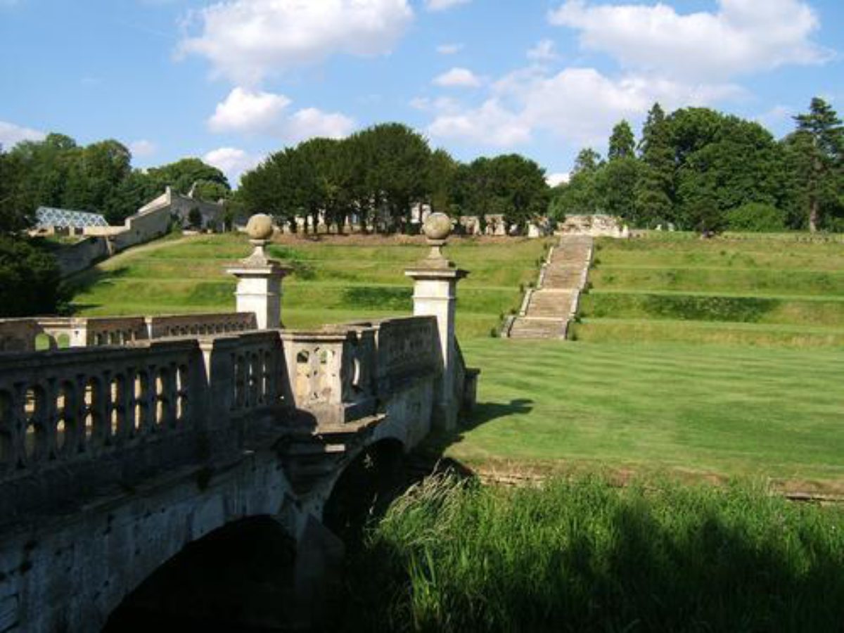
The gardens lie to the south-west, south-east, and east of the Hall site. To the south-west of the Hall site and below the house platform lie the terrace gardens. Stone steps lead down a series of grass terraces to a flat grassed area, the remains of a lawn. The gardens formerly consisted of an upper terrace on the south-west front with a retaining wall topped by a hedge as the south-west boundary, broken by a flight of steps leading westwards down grassed terraces to a lawn below, the lawn being planted with flower beds (CL 1902). South-west of the lawn is the River Witham. Between a weir to the north-west, immediately north of Forge Cottage, and a now (2000) disused hydraulic ram to the south-east, 200m from the Hall site, the river is canalised. The river is crossed by an ornate stone bridge (c 1840, listed grade II) which leads to the walled kitchen garden. A late C20 wooden bridge leads over the river, 50m north from the stone bridge.
The 1808 Enclosure map showed a square enclosure around the Hall, east of the canalised River Witham. The 1840 garden design incorporated a causeway between the terrace steps and the bridge but this had been removed by 1902 (CL) due to serious flooding of the flower beds in the lower garden (Glenn 1995).
To the south-east of the Hall site lie outbuildings and late C20 greenhouses. This was the site of the south lawn on which two fountains stood, removed in the 1950s (ibid). The lawn was laid out with circular flower beds (CL 1902). From the courtyard south of the gatehouse steps lead up to a garden terrace on which stands an ornamental gate (c 1840, listed grade II) flanked by railings. This gate led eastwards to the Temple Walk (ibid) which led to a structure known as the Temple situated on the edge of a quarry. Both the Temple and the Walk are now (2000) gone. A doorway flanked by stone niches and clipped yews opened onto a flight of steps leading down to the hollow of the old quarry (Glenn 1995).
PARK
The park lies north and south of the site of Easton Hall. The north parkland has an open aspect and is scattered with deciduous trees. Wooded belts run adjacent to the A1, the south part known as North Road Plantation. Post Office Plantation occupies the northern boundary, with Mill Hill Plantation lying to the north-east of the mansion site, Fisher's Plantation to the south-east, and Wellspring Plantation along to the south-east boundary of the park. The undulating southern park is made up of open park on either side of the southern approach drive, flanked by woodland.
The River Witham enters the site at the south-west edge of Wellspring Plantation, winding its way first to form the eastern boundary of North Road Plantation then running east to the disused hydraulic ram. From here it flows canalised through the south-west gardens to Forge Cottage, 160m north-west of the Hall site. From the Cottage the river flows east, crossed by the northern drive, and continues as the western boundary of Mill Hill Plantation. From the northern tip of the plantation the river crosses the open parkland then runs east as the southern boundary of Post Office Plantation. The river leaves by Easton Lane on the northern boundary of the park.
In 1805 Easton Hall was described as being 'in a beautiful valley, commanding a view of the Great North Road' (Turnor 1806). This valley is shown marked as Easton on Turnor's accompanying map. The 1808 Enclosure map shows the north and south Witham valley surrounded by fields. South of Public Road No 2 and east of the Hall was a strip of woodland. South of the garden enclosures and west of the river was a strip of woodland running north/south cut by a U-shaped enclosure marked by a line of trees. By 1872 (White) the park was described as 'a finely undulated and well-wooded park stocked with deer and crossed by the River Witham'. The boundaries of the park are marked on the 2nd edition OS map of 1905 and the line of Public Road No I remains as a footpath within the parkland.
KITCHEN GARDEN
The rectangular brick-walled kitchen garden (listed grade II along with the associated gardener's house and bothy, kitchen garden walls, gateway and gate, and two gazebos) lies 140m west of the Hall site, west of the River Witham. The west wall is broken by a gateway with ornate iron gates. Set against the middle of the north and south walls are two brick-built gazebos and at either end of the east wall are the gardener's house and bothy, both now (2000) converted into private dwellings. Both the gardener's house and bothy door are surmounted by a carved sheaf of corn, the crest of the Cholmeleys. A yew avenue (now very overgrown) runs from the stone footbridge at the bottom of the garden terraces to a set of cast-iron gates in the west wall of the kitchen garden. Yew hedges quartered the garden in the early C19 and during the alterations to the gardens in the 1840s, another yew hedge was planted to form the present yew avenue (Glenn 1995). A small gate in the north-east corner of the garden provides the present entrance.
A garden enclosure on the west bank of the River Witham is shown on the 1808 Enclosure map lying to the east of The Garden Close, an enclosure planted with regular rows of trees. By 1905 an avenue of limes was present (OS). This avenue, now (2000) interplanted with younger trees, leads from the Great North Road to the walled kitchen garden. The early C19 garden, with some alterations, was incorporated into the 1840 garden design to form part of the main west to east garden axis (Glenn 1995).
REFERENCES
E Turnor, Collections for the History of the Town and Soke of Grantham (1806), p 151
O Morris, Views of Country Seats III, (1866-80), p 74
W White, Directory of Lincolnshire, (1872)
Country Life, 11 (25 January 1902), pp 112-18
M Binney and A Hills, Elysian Gardens (1979), pp 48-9
N Pevsner et al, The Buildings of England: Lincolnshire (2nd edition 1989)
J Glenn, Easton Park, Lincolnshire (1995) [typescript report, copy on EH file]
H Thorold, Lincolnshire Houses (1999), pp 165-6
Maps
Edward Betham, The Lordship of Easton in the Soke of Grantham in the County of Lincoln 1808. Surveyed for the Commissioners of the Inclosure. [copy on EH file]
OS 6" to 1 mile: 2nd edition published 1905
Archival items
Conveyance of Easton Manor by Gilbert Bury Esquire to Sir H Cholmeley, 34 Elizabeth [1592] (private collection)
Description written: June 2000
Edited: May 2002
- Visitor Access, Directions & Contacts
Telephone
01476 530063Website
https://www.visiteaston.co.ukAccess contact details
http://www.eastonwalledgardens.co.uk/visitor-information/groups/
Directions
On the A1 from the South, go under two bridges at Colsterworth. Just after the 2nd bridge take the left turn to Easton/Ancaster and go up over the bridge. Turn Right on B6403. After about 1 mile, turn left into the village of Easton. The Car Park is on the left.On the A1 from the North, 8 miles south of Grantham you pass the park and gardens on your left. Turn left off the A1, sign-posted B6403 to Easton. After about 1 mile, turn left into the village of Easton. The Car Park is on the left. Please see: http://www.eastonwalledgardens.co.uk/visitor-information/
- History
The landscape park in an area of South Lincolnshire described by Dr William Stukeley as 'the Montpelier of England' adjoins the small village of Easton and stone cross (1841) "in a beautiful valley, commanding a view of the Great North Road (A1)" (Turnor, 'Grantham', (1805)) now screened by belt planting. The land was once owned by the Cistercian Abbots of Vaudey Abbey. Legend has it that the body of Queen Eleanor rested at Easton on her way to burial in 1296. In 1443 by John Eston Esq and has been the home of the Cholmeley family from Cheshire since 1592, the medieval house stood on the hill east above the River Witham that runs through the valley. The gardens are known to have had seventeenth century fountains. The river Witham was canalised by the time of the 1805 survey. The ha-ha, the winding approach drives from lodges north west (Gothic), and south (demolished), picturesque planting and the horse chestnut avenue, date from the late eighteenth century/ early nineteenth century when Montague Cholmeley (d.1803) was married to Sara Sibthorp the daughter of Humphry Sibthorp MD of Oxford, who had a keen interest in botany, horticulture and trees. His son Sir Montague Cholmeley, Whig MP, rebuilt the house in 1805. This was again greatly extended by his son, but demolished after WWII.
A splendid French-style formal garden was created in the 1840's on a strong east/west axis with statuary, lions, griffins and stone dogs and fountains. It included steps and wrought iron gates initialled MIC leading to Temple Walk east to a tall archway with open pediment quarry/grotto garden, and seven great garden terraces west and steps leading down a causeway (now gone) to the river, where an ornamental stone bridge led to the walled garden west. This enclosure, probably on the site of an earlier kitchen garden or orchard, is divided by a yew walk, with decorative pavilions north and south (apple store and ‘tool tower') and an iron grill, flanked by pavilions, with wrought iron gates initialled MIC leading to a double lime avenue towards the Great North Road (A1). In 1836 architect Anthony Salvin (1799-1881) is thought to have designed these Tudor-style estate buildings in addition to the Jacobean gatehouse and stables (1841) that are decorated with the Cholmeley crest - a sheaf of corn. ‘The garden with its terraced banks is very pretty, and the altered entrance from the village I like extremely.' ( Lincoln Record Society, ‘Cholmeley Letters.'September 1850).A mid-nineteenth century commentary records the scene:
‘A combination of boldly designed carpet beds on either side of the raised road leading to the bridge over the Wytham & along the front of the river, with circular beds & quarter circles surrounding then filled with flowering plants. When the late Mr John Edlington was here the garden was for the most part filled with herbaceous plants & pyramidal trees in picture- severely injured by the severe frosts of last winter & the fine Irish yews were injured beyond the hoe of recovery. Standard roses killed, box trees, Portugal laurel, common laurel & even a couple of fine Cedars of Lebanon.' (Sir Bernard Burke ‘Visitation' (1852-1854))
Franklin D. Roosevelt, later US President, spent part of his honeymoon at Easton, and considered it his 'dream of Nirvana'. In1909 the park hosted an early golf pro am 9-hole tournament with famous professionals such as Harry Vardon. A major and imaginative reincarnation of the overgrown gardens was begun in 2000, 20 tons of debris were removed, the terraces reseeded, and thousands of bulbs planted. However, early varieties of narcissus have appeared after clearances, including Narcissus ‘Van Sion' and Victorian hybrids.
The following is from the Register of Parks and Gardens of Special Historic Interest. For the most up-to-date Register entry, please visit the The National Heritage List for England (NHLE):
www.historicengland.org.uk/listing/the-list
HISTORIC DEVELOPMENT
The medieval manor house and village of Easton was sold to Sir Henry Cholmeley (1562-1620) in 1592. The manor house remained within the Cholmeley family, passing from father to son and in 1803 to Sir Montague Cholmeley (1772-1831), MP for Grantham. Sir Montague, who was created a baronet in 1806, rebuilt the Hall in 1805. The Enclosure map of 1808 shows garden enclosures. Sir Montague's son, also Sir Montague (1802-74), the second baronet made major alterations to the Hall and had gardens laid out in the 1840s. His grandson, Sir Hugh Arthur Henry Cholmeley (1839-1904) made alterations to the terrace gardens. The Cholmeley family ownership continued into the 20th century. The Hall and its grounds were requisitioned during the Second World War by the army and the Hall was demolished in the early 1950s. The gardens were used as a market garden from the 1950s until the 1980s. The gardens and park remain (2000) in private ownership.
- Associated People
- Features & Designations
Designations
The National Heritage List for England: Register of Parks and Gardens
- Reference: GD1974
- Grade: II
Plant Environment
- Environment
- Walled Garden
Style
French-Style Garden
Features
- Drive
- Canal
- Canal
- Reposoir
- Stable
- Gatehouse
- Gate
- Gate
- Steps
- Orchard
- House
- Orchard
- House
- River
- Ornamental Bridge
- Shelter Belt
- Screen
- Ha-ha
- Religious, Ritual And Funerary Features
- Hall (featured building)
- Description: The hall was built in 1805 and demolished in the early-1950s.
- Earliest Date:
- Latest Date:
- Key Information
Type
Park
Purpose
Ornamental
Plant Environment
Environment
Principal Building
Heritage Site
Survival
Extant
Hectares
100
Open to the public
Yes
Civil Parish
Easton
- References
References
- {English Heritage Register of Parks and Gardens of Special Historic Interest}, (Swindon: English Heritage, 2008) [on CD-ROM] Historic England Register of Parks and Gardens of Special Historic Interest
- Pevsner, N. and J. Harris, {The Buildings of England: Lincolnshire} (London: Penguin, 2nd edition 1989) The Buildings of England: Lincolnshire
Contributors
Steffie Shields
Lincolnshire Gardens Trust