Introduction
Belton House has a 17th-century landscape park of 270 hectares with later 18th-century additions, and 19th-century ornamental gardens of four hectares.
www.historicengland.org.uk/listing/the-list
A late 17th-century park and the remains of late 17th-century gardens and early, mid-, and late 19th-century gardens forming the setting for an early 18th-century country house.
DESCRIPTION
LOCATION, AREA, BOUNDARIES, LANDFORM, SETTING
Belton House and its surrounding park are located 4.25km north-east from the centre of Grantham, the registered site comprising an area of c 505ha. The northern boundary of the site leads south-east from Belton village along the northern boundary of the pleasure grounds then continues north-westwards to join the unclassified road from Belton. From here the boundary continues east to Whipperstall Hill and then south-eastwards along Beggar's Lane to the north-east corner of the site. The eastern boundary runs south through woodland and Bellmount Plantation to the south-east corner of the site. The southern boundary leads south-west with arable land to the south and parkland to the north, before continuing westwards as Londonthorpe Lane to the south-west corner of the site. The western boundary runs north, west of the perimeter plantations of Grantham Gate Plantation and Mill Plantation, then crosses the River Witham before continuing northwards adjacent to the A607 to the north-west corner of the site.
ENTRANCES AND APPROACHES
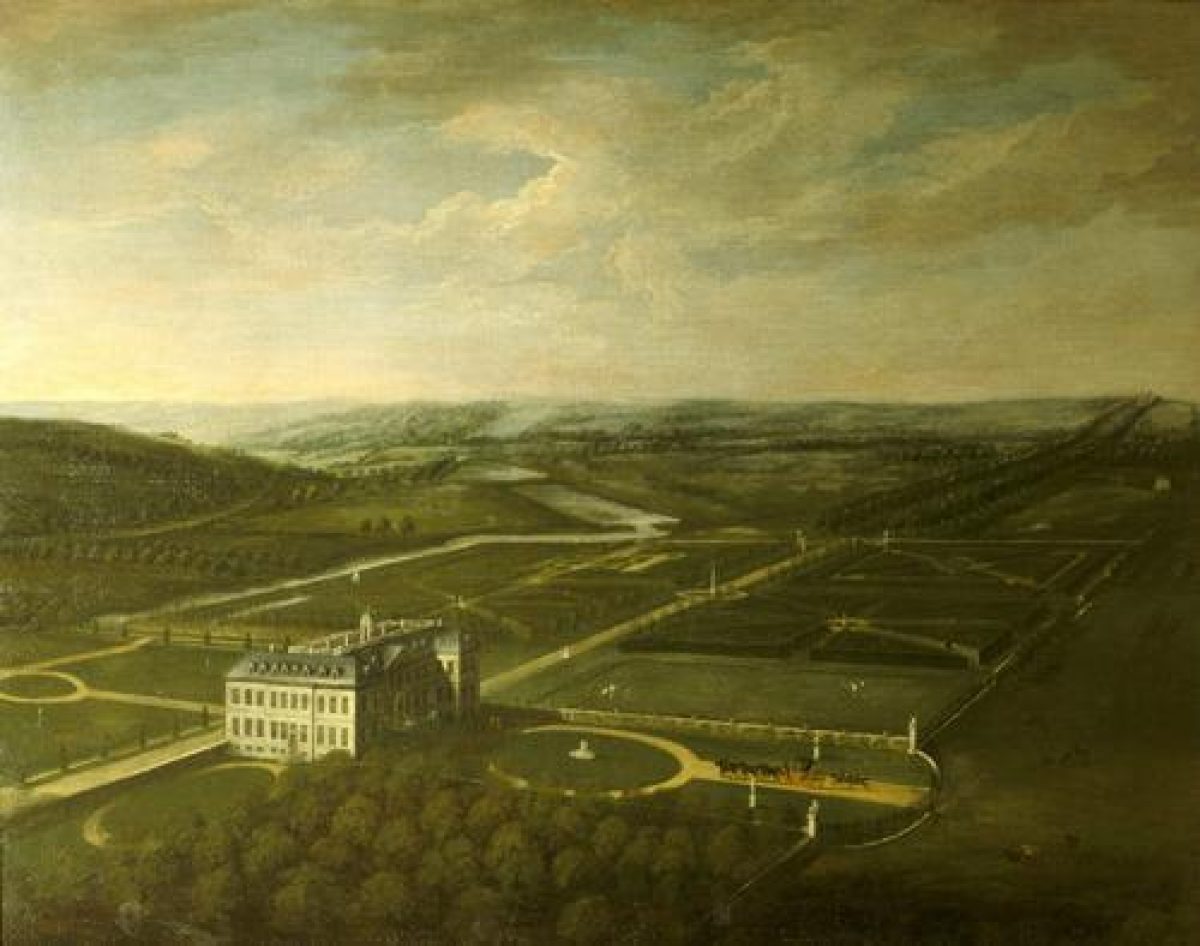
The entrance to the site is from Belton village which lies to the north-west. The drive enters by North Lodge (mid C19, with later C19 and C20 additions, listed grade II together with the gateway, screen walls, and guard stones adjoining the Lodge) and continues south for 180m then east for 100m to arrive at the entrance courtyard. The north part of this drive may have been part of the road, present from 1690, which ran from Belton village south through the parkland (National Trust 1985, vol II). The west entrance to the House is illustrated in an anonymous painting of the late C17 showing Henry Bug, Sir John Brownlow's porter outside a rectangular court enclosed by wrought-iron screens with gate piers on an axis with the entrance (guidebook 1990). Viscount Tyrconnel replaced the screens with a clairvoie which enclosed a larger area in the early C18 (guidebook 1999). The South Avenue runs from the Lion Gates which stand on Londonthorpe Lane in the south-west corner of the site, past Lion Lodge, passing between two of the lakes and continuing to the turning circle south of the House. This drive is shown on the 1690 map and there may have been a road running south to north, west of the present (1999) avenue (National Trust 1985, vol II). By the early C20 the South Avenue was little used except on ceremonial occasions (ibid).
PRINCIPAL BUILDING
Belton House (listed grade I), of three storeys in Ancaster and Ketton ashlar with a hipped slate roof, was designed by William Winde (d 1722) and built between 1685 and 1688 by William Stanton. The old manor house had been demolished in 1684 and the stone was re-used in the new house. The House was altered in 1777 by James Wyatt (1747-1813) and c 1816 by his nephew, Jeffrey Wyatville (1766-1840). Further alterations were made in c 1870-1900, possibly by J H Pollen. The west, entrance front has ten bays and forms the east side of the West Court. Both the north and the south fronts have twelve bays altogether, with two projecting bays at either end and a pedimented canted central bay with central doorcase above steps. The east front has ten bays.
The service wing to the House (listed grade II*) forms the west and north sides of the West Court. The west range, topped with an octagonal wooden cupola with a clock dial, was built 1685?-8; the north range is of late C19 date. The former brewhouse (listed grade II*) 30m west-north-west of the House, designed in 1820 by Wyatville and built of ashlar with gabled slate roofs, is now (late C20) a gift shop. North of the brewhouse are the former stables (c 1688 with late C19 additions and C20 alterations, listed grade I), designed by William Stanton and built of coursed squared stone with ashlar front and dressings and gabled roofs. The courtyard (east) front is of two storeys with pedimented centre and moulded pedimented doorcase. The stables are now (1999) tea rooms. The early C18 screen and gateway (listed grade II*) on the south side of the West Court was probably designed by John Warren.
GARDENS AND PLEASURE GROUNDS
The gardens lie to the east, north, and north-west of Belton House with the pleasure grounds extending eastwards from them. There are two lakes within the pleasure grounds to the east of the gardens, Boathouse Pond and Tar Lane Pond. The boundary between the eastern gardens and the pleasure grounds is marked by a fence, as is the southern boundary of the gardens and pleasure grounds with the parkland. Some 350m east of the House across Bellmount Avenue is a ha-ha (c 1800, listed grade II), of brick with ashlar coping.
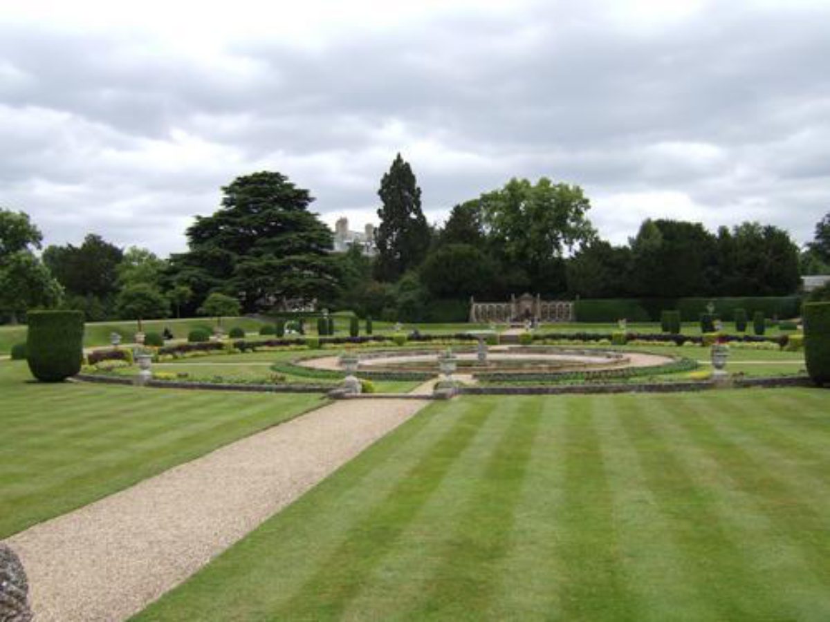
The Dutch Garden, created in 1879 by the third Earl Brownlow on the site of the formal early C18 gardens illustrated in Vitruvius Britannicus (1717), lies on an axis with the central steps from the north front of the House. The Dutch Garden is square with a rounded end to the north, marked by hedges with a central main path lined with clipped yews. On either side of the path there are late C18 quatrefoil-section cisterns (listed grade II) made of limestone. From these centrally placed cisterns short paths lead to perimeter paths. From the Dutch Garden the axial path continues to a sundial (Caius Gabriel Cibber (1630-1700) c 1690, listed II*), a figure of Time made of Portland stone, seated on a globe and supporting a baluster column with the assistance of a cherub. The brass dial is inscribed and signed by Thomas Wright, 1725. The sundial was previously located in the centre of the turning circle on the south front (National Trust 1985, vol I). The path continues 70m from the sundial to a white marble statue representing Ceres (J Franchi 1850, listed grade II), standing at the junction of the axial path from the House and a path running from east to west.
The Italian Garden lies 200m to the north-west of the House on the site of the kitchen garden which was removed in the early C19. It is a rectangular terraced garden with steps at each corner and contains an inner circle with steps down to a central fountain. The Italian Garden was first laid out 1810/11 to a design by Wyatville although some features are later additions c 1870-1900 by the third Earl Brownlow (guidebook 1999) and the majority of the features, which include the terrace wall, steps, and urns (listed grade II), were designed by Jeffrey Wyatville. At the southern end of the central axis through the Italian Garden lies the Lion Exedra (listed grade II), designed in 1820 originally for the Dell but relocated to the Italian Garden in 1921 (ibid). At the northern end of the central axis through the Italian Garden stands the Orangery (listed grade II*), designed in c 1811 by Jeffrey Wyatville and built in 1821. It is in the Classical Revival style, of ashlar with nine fully glazed bays and a hipped roof. It occupies the site of the old manor house which was demolished in 1684 prior to the construction of Belton House.
To the north of the Orangery is a grassed courtyard with cross paths which was the courtyard of the old manor. West of the courtyard are C20 glasshouses. A path leads south from the glasshouses towards the steps (listed grade II) on the north terrace of the e Italian Garden.
Eastwards from the statue of Ceres at the junction of the axial path which leads north from Belton House, a network of paths provide access to the eastern part of the garden. A semicircular path leads north-east past a Gazebo (c 1840) then continues east to drop south-east to meet the main west/east path from the Orangery. At this junction the path divides, continuing on either side of the Canal Pond (formed c 1684) which lies 130m from the House and survives from the gardens created for Sir John Brownlow shown in Vitruvius Britannicus. At the east end of the Pond, 200m from the House on the east side of the path, is the Palladian-style garden temple (1820, listed II*) with an ashlar front, central archway, rusticated piers, and a slate roof.
On the north side of the path which leads east from the Dutch Garden stand two pairs of life-size marble statues: a female with a posy and a male with a spade (early C18, possibly designed by C G Cibber, listed grade II); and a pair of females, one draped and the other undraped (possibly late C17, listed grade II). The path forms the northern boundary of the Eastern Avenue of limes, a continuation of Bellmount Avenue. This area was the site of the Great Pond, flanked by formal parterres, which formed part of Sir John Brownlow's garden of the late C17 illustrated in Vitruvius Britannicus. The Great Pond broke its banks in 1751 and was drained shortly after (guidebook 1999). By the 1750s the area had become a walk, with an obelisk midway along the walk still flanked by parterres (Badeslade, in National Trust 1985, vol I). A ha-ha (c 1800, listed grade II) marks the boundary between Eastern Avenue and Bellmount Avenue. An early C20 maze situated 250m east of Belton House is now (1999) gone.
To the west of the main entrance drive is a c 12ha wooded area known as the Wilderness, laid out in the 1740s for Sir John Brownlow, Viscount Tyrconnel. The entrance gates and railings (listed grade II*) to the Wilderness, located 150 west of the House, are early C18, resited mid C18 and extended C19. A gothick ruin, cascade and footbridge (all listed grade II) are located within the Wilderness 200m north-west of the House. The structure was created for Viscount Tyrconnel by draining a stream to create a waterfall and is illustrated in an engraving by Francis Vivares of 1749 (guidebook 1999). It was restored by the first Earl in the early C19, again in the late C19, and once more in the late C20. Trees are planted to the east of the public road (A607) and east of the trees the River Witham makes its serpentine way from south to north through the Wilderness. A summerhouse (designed c 1829) is located 350m south-west of the House. The Boathouse (c 1800, listed grade II) located 200m west of the House has rustic woodwork with a brick plinth. In 1976 an adventure playground was constructed between the cascades and the western boundary of the site. A miniature railway has also been built (late C20) in the Wilderness.
The pleasure grounds to the east of the gardens are entered by a large stile off the eastern boundary path of the garden, 500m north-east of the House. The path through the pleasure grounds leads east for 140m then divides, one continuing east between Boathouse Pond and the northern boundary of the site. This continues east, north of the stream joining Boathouse Pond and Tar Lane Pond and of Tar Lane Pond itself. At the north-west corner of Tar Lane Pond the path divides and goes around the Pond. Just short of this division another path drops south-west off the main path, crosses the stream and runs south-west to the south-east corner of Boathouse Pond. It then continues around the southern edge of the Pond and leads past the Cascade. The Cascade (early C18, listed grade II*), which stands the south-west edge of Boathouse Pond, may have formed part of the gardens and pleasure grounds carried out for Sir John Brownlow, Viscount Tyrconnel c 1702-54. The path continues northwards to the Boathouse (listed grade II) which was designed in the form of a Swiss chalet by Anthony Salvin (1799-1881); it is now (2000) being renovated. The ponds which were formed by damming the north stream which feeds into the River Witham were present by c 1750 (Badeslade, in National Trust 1985, vol I). By the early C19 a selection of exotic trees had been planted around the ponds (guidebook 1999) and later in the C19, the third Earl supplanted these with conifers and rhododendrons (National Trust 1985, vol II).
PARK
The House stands in the north-west corner of its extensive park. Sir John Brownlow was licenced in 1690 'to enclose and Impark such of his lands in Belton Manthorpe and Londonthorpe ... as he shall think fitt and Convenient for ye propertie not exceeding one Thousand Acers' (ibid). A road, known by c 1800 as Five Gates Road, runs south-eastwards from the unclassified road 0.85km north-east of the House past Leg o' Mutton Pond, then crosses Bellmount Avenue and leaves the park at Brigade Gate, 1.6km south-east of the House. To the east of Five Gates Road is Bracken Plantation which lies adjacent to the pleasure grounds, with Hopyard Plantation to the north. Other clumps of woodland lie north-east and east of Hopyard Plantation. A long thin plantation, Oak Plantation, extends from Hanging Wood which lies north-west of Bellmount Plantation.
The eastern avenue, known as Bellmount Avenue, is now (1999) planted with horse chestnut and lime trees. It runs from the east front of the House to a ha-ha, once the Great Pond, continuing to Bellmount Tower at the eastern edge of the park. The Tower (listed grade II), built c 1750 for Viscount Tyrconnel as a viewing tower in the form of a tall arch, stands 1.95km east of the House, backed by Bellmount Plantation. West of Five Gates Road and south of Bellmount Avenue, the park is grazed. Within the parkland, 0.75km south-east of the House stands the Alford Memorial, designed by Richard Westmacott and erected by Baron Brownlow to his son and heir, who predeceased him, soon after Viscount Alford's death in 1851. Old Wood lies c 1.1km south-east of the House; it is shown on the 1690 map as rectangular and cut by a series of rides. To the south-west of the Wood is Villa Plantation, surrounding Villa Pond. To the west on either side of the South Avenue are Great Towthorpe Plantation and Little Towthorpe Plantation. Towthorpe Hollow Ponds flow towards the River Witham on the west of the site. South of Little Towthorpe Plantation is Mill Plantation and south of that is Grantham Gate Plantation. East of the Lion Gates is Old Warren Plantation. Baron Brownlow made many improvements to the park, establishing plantations on the south of the park and others on the east in the late C18. He may also have created the Villa Pond in c 1772 (Belton House Park map, 1990). The first Earl created the ponds in the west of the parkland at Towthorpe Hollow in c 1825 (Belton House Park map, 1990).
To the south of the Villa Pond, within the parkland, is a golf course, first created in 1892 for the third Earl Brownlow, with the golf clubhouse set on the edge of woodland 30m from the southern boundary. At the outbreak of the First World War the original golf course was removed and an army camp was built over an area which stretched from the site of the golf course to Bellmount Tower. The camp was served by a railway from Peascliffe to Bellmount (National Trust 1985, vol II). The golf course was subsequently re-instated. A road was built between 1780 and 1784 for the first Baron Brownlow which ran from the Lion Lodge north-eastwards to the edge of Villa Pond, then northwards across the parkland and through the pleasure grounds to the unclassified road which runs east of Belton village to Ermine Street. This road had gone by 1887 (OS) but its line is visible on aerial photographs taken in 1975 (National Trust 1985, vol II).
KITCHEN GARDEN
The 2ha walled kitchen garden, now (2000) a garden centre, is located to the west of the A607, 500m from Belton House. By 1886 the garden was divided into three walled areas with glasshouses in the central area on the north wall (OS).
REFERENCES
H I Triggs, Formal Gardens in England and Scotland (1902)
Country Life, 136 (3 September 1964), pp 562-5; (10 September 1964), pp 620-4; (17 September 1964), pp 700-3
J Anthony, The Gardens of Britain 6, (1979)
J Harris, The Artist and the Country House (1979)
B Jones, Follies & Grottoes (1979)
Belton Park: vol I, The Garden; vol II, Park History; vol III, Park Survey, (unpublished report, National Trust 1985)
N Pevsner et al, The Buildings of England: Lincolnshire (2nd edn 1989)
Belton House, Lincolnshire, guidebook, (National Trust 1990)
Belton Park, Storm Damage Report, (National Trust 1991)
Belton House, Lincolnshire, guidebook, (National Trust 1992, revised 1999)
Maps
An Exact Map of Belton Lordship with Part of Londonthorpe, 1690 [copy on EH file]
OS 6" to 1 mile: 2nd edition published 1906
OS 25" to 1 mile: 1st edition surveyed 1888, published 1889
Description written: May 2000
Register Inspector: CEB
Edited: May 2002
- Visitor Access, Directions & Contacts
Telephone
441476566116Access contact details
http://www.nationaltrust.org.uk/place-pages/27/pages/opening-times-calendar
- History
The following is from the Register of Parks and Gardens of Special Historic Interest. For the most up-to-date Register entry, please visit the The National Heritage List for England (NHLE):
www.historicengland.org.uk/listing/the-list
HISTORIC DEVELOPMENT
Belton Manor was owned by St Mary's Abbey, York until the Dissolution of the Monasteries in the 1530s. By 1603 the manor house was owned by Henry Pakenham who sold it to Richard Brownlow (1553?1638), a successful lawyer. Sir John Brownlow (1594-1679), first Baronet of Belton, known as Old Sir John to distinguish him from his heir, Young Sir John, was created a baronet by Charles I in 1641. He created formal gardens and the Great Pond. His great-nephew 'Young' Sir John Brownlow (1659-97), the third baronet, built the present Belton House between 1685 and 1687/8 and created new formal gardens and ponds. He was succeeded briefly by his brother, Sir William Brownlow (1665-1702), the fourth baronet. His son, Sir John Brownlow (1690-1754), the fifth baronet, created Viscount Tyrconnel and Baron Charlesville in 1718, had Bellmount Tower built and alterations made to the gardens. His nephew, Sir John Cust (1718-70), third Baronet of Pinchbeck, sixth Baronet of Humby, Speaker of the House of Commons 1761-70, inherited in 1754. His son, Sir Brownlow Cust (1744-1807), seventh baronet, created Baron Brownlow in 1776, inherited in 1770 and under his ownership major alterations were made to the garden and park. Commissioned by Lord Brownlow, William Emes (1730-1803) prepared a Plan of the Park and Demesne ... with some Alterations but it was largely unexecuted (guidebook 1999). Baron Brownlow's son, John Cust (1779-1853), second baron was created first Earl Brownlow and Viscount Alford in 1815 and further alterations were made to the garden. When the Earl died his grandson, John William Spencer Egerton Cust (1842-67) inherited as third baron at the age of eleven. When John Cust died at the age of twenty-five in 1867, his brother Adelbert Wellington Brownlow Cust (1844-1921) became the fourth baron and the third and last Earl Brownlow. He restored the gardens and created a Dutch Garden. When the third Earl died in 1921 the earldom became extinct and Belton was inherited by the Earl's great uncle's grandson, Adelbert Salusbury Cockayne Cust (1867-1927) who became fifth Baron Brownlow. His son, Peregrine Adelbert Cust (1899-1978), the sixth baron inherited in 1927. During the Second World War the gardens of Belton House were run as a market garden for the war effort. When Lord Brownlow died in 1978, his son Edward John Peregrine Cust (born 1936) became the seventh baron. In 1984 he gave Belton House, its garden and garden sculpture to the National Trust which then bought the park of 1317 acres (about 549 hectares). Also in 1984 the Bellmount Tower was acquired separately with a donation. Belton House and park remain (2000) in National Trust ownership.
- Associated People
- Features & Designations
Designations
The National Heritage List for England: Register of Parks and Gardens
- Reference: GD1429
- Grade: I
Features
- House (featured building)
- Earliest Date:
- Latest Date:
- Orangery
- Fountain
- Planting
- Description: Italian garden.
- Key Information
Type
Park
Purpose
Ornamental
Principal Building
Domestic / Residential
Survival
Extant
Hectares
502
Open to the public
Yes
Electoral Ward
Grantham St John's
- References
References
- {English Heritage Register of Parks and Gardens of Special Historic Interest}, (Swindon: English Heritage, 2008) [on CD-ROM] Historic England Register of Parks and Gardens of Special Historic Interest
- Harris, J., {The Artist and the Country House} (London: Russell Chambers, 1979) The Artist and the Country House
- Anthony, J., {The Gardens of Britain 6: The East Midlands} (London: Batsford, 1979 The Gardens of Britain 6: The East Midlands
- Pevsner, N. and J. Harris, {The Buildings of England: Lincolnshire} (London: Penguin, 2nd edition 1989) The Buildings of England: Lincolnshire
- Gardens Survey Team, National Trust {A survey of the gardens and park at Belton} (1986) A survey of the gardens and park at Belton
- Related Documents
-
CLS 1/143/1
Report on Park and Gardens: Vol. 1 The Garden - Hard copy
Manpower Services Commission, Park Survey Team - 1985
-
CLS 1/143/2
Report on Park and Gardens: Vol. 2 Park History - Hard copy
Manpower Services Commission, Park Survey Team - 1985
-
CLS 1/143/3
Report on Park and Gardens: Vol. 3 Park Survey - Hard copy
Manpower Services Commission, Park Survey Team - 1985
-
CLS 1/143/1