Introduction
The site originated in the medieval period. The remnants of a late-17th-century formal garden are largely overlain by the remains of a small 18th-century landscape park, which at its most extensive covered about 18 hectares. Only about 7 hectares now survive, with a 20th-century formal garden and lawns beside the house.
Terrain
Largely flatwww.historicengland.org.uk/listing/the-list/
A late C17 country house surrounded by a compact 1760s/70s landscape park, possibly by Lancelot Brown, overlaid on the remains of a formal late C17 garden.
DESCRIPTION
LOCATION, AREA, BOUNDARIES, LANDFORM, SETTING
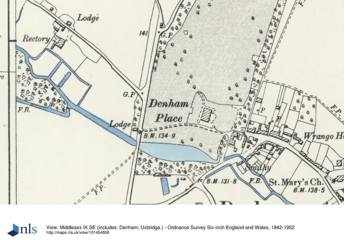
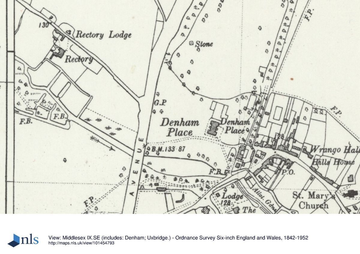
Denham Place lies 4km north-west of Uxbridge and 4km east of Gerrards Cross, at the west end of Denham's main street, Village Road, in the broad River Colne valley at the eastern end of the Chiltern Hills. The 17ha site is bounded to the west by the A412 Denham Avenue, to the south by Village Road running off Denham Avenue into the main street, and to the north and east by agricultural land and public footpaths. Much of the boundary is defined by a 1km long, 3m high C17-C19, red-brick wall (listed grade II), with a coping of vertically laid bricks raked to a point. This runs south from the north-east corner of the park, broken by occasional gateways, encircling the southern end of the estate and running north to just north of the road bridge over the River Misbourne on the west boundary. The site is largely flat, with a low rise running from west to east across the middle, north of the house, defined by fruit trees and modern conifers. The setting to the east is dominated by the adjacent village; the remainder is agricultural interspersed with small mid to late C20 settlements and busy trunk roads to the west and south. There are few views out of the estate as the area is largely visually self-contained.
ENTRANCES AND APPROACHES
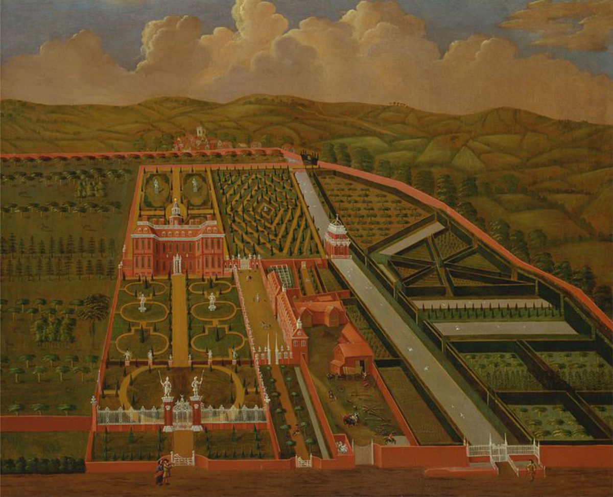
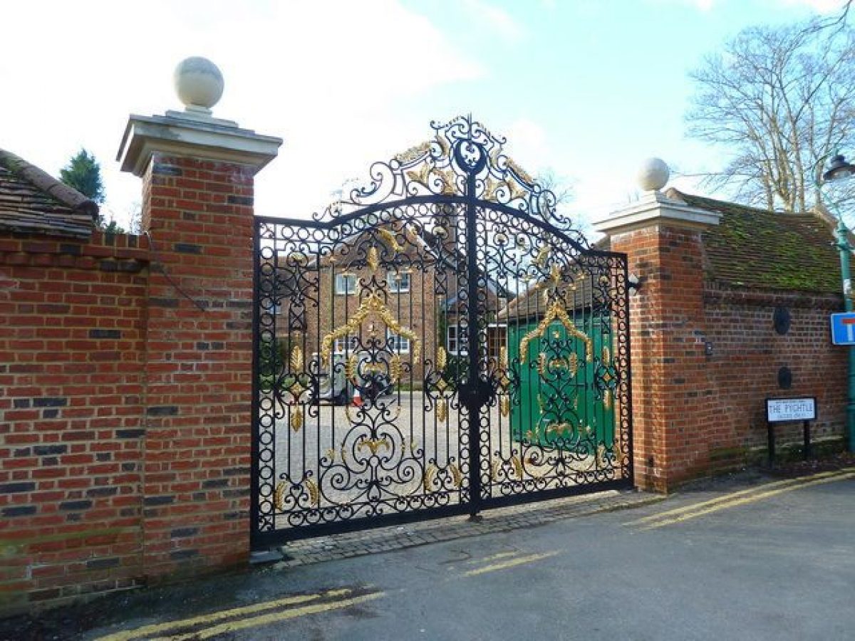
The main approach, off Village Road adjacent to the village green, enters 100m east of the house, running through the stable yard via a break in the boundary wall, past brick gate piers with ball finials supporting wrought-iron gates. From here a view east along the village street is obtained. The drive curves north and returns west, along a straight gravel drive flanked by lawn panels, on an axis with the east front of the house, arriving at a rectangular gravel sweep with a short flight of balustraded stone steps to the main door. The basement well is screened by low clipped yew hedges flanking the door. A further drive enters south of the lake on the west boundary, 200m south-west of the house, through a break in the boundary wall, past brick gate piers with wrought-iron gates (c 1690, listed grade II), with arms amid scroll work over them. A small C18/C19 one-roomed brick lodge lies between the drive and the lake, close to the gates. The slightly raised drive (now disused and mostly grassed over) curves east between the south side of the lake and the north wall of the walled garden, with views of the house and its reflection in the lake, crossing the eastern end of the lake via the Old Bridge (late C17, listed grade II), a small bridge of two semicircular brick arches (shown on the 1705 painting). Views into the village street east of the bridge are blocked by the boundary wall on its east edge. The drive runs north-west straight from the bridge to the south-east corner of the house, flanked by the remains of an avenue of trees, to join the gravel sweep east of the house. A further drive, shown on a map of 1783 (BRO), entered north of the west end of the lake, running straight across the landscaped park to the south-west corner of the house and gravel sweep on the west front, with a spur along the south front to a sweep on the east front.
PRINCIPAL BUILDING
Denham Place (listed grade I) lies towards the centre of the estate, surrounded by largely level lawns and a formal garden on the north side. It was built for Sir Roger Hill by the mason contractor William Stanton between 1688 and 1701, on the site of a C16 house. It is a two-storey block, of H-plan, with a hipped roof, a descendent of the Clarendon House type (c 1665), with good views of the surrounding garden from all sides. The main entrance on the east front was moved, c 1760s/70s, from the west front as shown on the 1705 painting, which also shows a balustrade on the peak of the roof, with a cupola in the centre, which was removed c 1830s.
The stables (listed grade II) lie 75m south-east of the house; said to be C17 (Pevsner 1994), they are not shown on the 1705 painting and possibly were constructed after the 1770s' landscaping from C17 bricks reused from the earlier stables to the south-west of the house which were removed at this time. The red-brick building is constructed around a small, east-facing, three-sided courtyard, with a brick wall closing the court on the east side. A semicircular-arched carriageway runs through the west range with a wooden cupola above, with ornamental features on the west side including a pediment, Diocletian windows and blind arches flanking the archway below, presumably designed to be seen from the park on the west side. Adjacent to the east side of the stables lies a courtyard bounded to the south and east by the estate boundary wall, with lean-to coach houses attached, and the main (originally service) entrance. South of the stables a small enclosed area is bounded to the south and east by the boundary wall, running down to the river where it emerges from beneath the Old Bridge before disappearing under the wall.
GARDENS AND PLEASURE GROUNDS
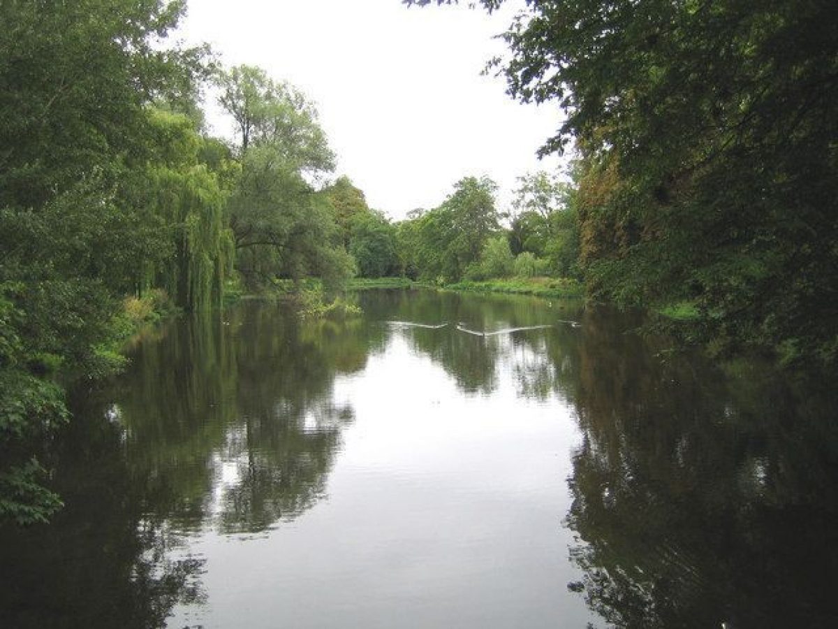
The level gardens occupy the southern end of the estate, and are mainly laid to lawn with scattered specimen trees, separated from the park to the north by a narrow barrier of fruit trees and conifers. The area west and south of the house, covered until the 1760s(70s by the formal garden showed in the 1705 painting, then incorporated into the parkland with formal features added in the C19 (now gone), is largely level lawn, with traces of earlier structures visible as parchmarks during dry weather, and, close to the lake, two very large plane trees aligned with the south front of the house. The dominant feature is the broad lake to the south dividing the southern area in half, created from the River Misbourne as it enters from the west, and dammed at the east end, leaving the garden under the Old Bridge on the east boundary. The informal area south of the lake, with the south-west drive running through it, contains many mature ornamental trees, bounded on the south by the north wall of the walled garden. This enclosed area appears to have been used both ornamentally, in the northern half, and as a kitchen garden, to the south. It is surrounded by the estate wall on the west, south and east, and bounded to the north by a further brick wall (C18, listed grade II), in similar style to the boundary wall, with three gateways, two pedestrian and, at the east end, one vehicular, with square brick piers and wrought-iron gates. A trapezium-shaped pond lies at the centre of the walled garden, a remnant of the C17 layout, with several mature cork oaks on its east edge, and a further, irregular pond (?C19) east of these. The area is maintained as a meadow with scattered trees.
The main formal feature lies north of the house: a rectangular sunken garden with a north/south stone path on an axis with the north front of the house leading from the low iron gates at the south end to a yew-backed seat at the north end. The area is surrounded by a clipped box hedge and flanked to west and east by tall, clipped yew hedges and enclosed lawns. It is screened from the park to the north by a row of late C20 conifers, and was constructed in the 1930s by the Vansittarts.
PARK
The park, shown in part in the 1705 painting with a formal arrangement of trees, now occupies only the north half of the estate, starting 50m north of the house, although in the late C18 (1783 map) it surrounded the house, incorporating the lake, and extending south to the walled garden. It consists (1997) of an open meadow surrounded by a shelter belt on all but the south side, with a circuit walk through it and glimpses of the house to the south. The circuit walk, through mature trees including several pollarded sweet chestnut trees of great girth under-planted with evergreen shrubs including holly, yew, box and ruscus, has been restored (1990s) and may not currently lie on its original course in places. Almost none of the parkland trees shown on the 1783 map in clumps and singles survive, although it is still largely meadow, with orchard trees at the north end, and a small C20 iron railing-bounded cemetery at the west edge.
REFERENCES
J Garden History 8, nos 2 & 3 (April-September 1988), pp 235-6
Country Life, 18 (18 November 1905), pp 702-9; 57 (18 April 1925), pp 602-9; (25 April 1925), pp 642-53; 116 (15 July 1954), p 209
D Stroud, Capability Brown (1975), p 222
J Harris, The Artist and the Country House (1979), p 123, pl 14
N Pevsner and E Williamson, The Buildings of England: Buckinghamshire (1994), pp 270-3
Maps
Map of the parish of Denham, 1783 (Ma/W/99), (Buckinghamshire Record Office)
OS 6" to 1 mile:
1st edition published 1883
2nd edition published 1900
3rd edition published 1932
OS 25" to 1 mile:
1st edition published 1881-2
2nd edition published 1899
Description written: 1997
Register Inspector: SR
Edited: June 1999
- Visitor Access, Directions & Contacts
Directions
4 kilometres north-west of Uxbridge and 4km east of Gerrards Cross.
- History
The following is from the Register of Parks and Gardens of Special Historic Interest. For the most up-to-date Register entry, please visit the The National Heritage List for England (NHLE):
www.historicengland.org.uk/listing/the-list/
HISTORIC DEVELOPMENT
The estate was part owned by the Abbey of Westminster until c 1540, subsequently passing through several hands until bought in the late C17 by Sir Roger Hill, Member of Parliament for Wendover and High Sheriff of Buckinghamshire, who rebuilt an existing house between 1688 and 1701. He surrounded it with elaborate formal gardens to the west, south and east, with over sixty pieces of sculpture and a geometrical canal, with the entrance to the house on the west front, as shown in a painting of c 1705, possibly by John Drapentier (Harris 1979). The main east/west axis of the house was flanked to the south by a further formal walled garden area, also aligned east/west, a stable block to the south-west of the house and a geometrical canal running the whole east/west width of the estate, divided by a water pavilion c 100m south of the house. In 1742 the estate was inherited by the Way family, with whom it remained until 1920. The formal gardens were removed by Benjamin Way c 1770s, except for the walled garden to the south and one of the ponds within it (although various other items and structures still remain, some relocated), replaced by a lake within a landscape park, following which the entrance front of the house was altered from the west to the east. It is possible that Lancelot Brown (1716-83) was connected with the layout (CL 1925, 604; Stroud 1975, 222). During the mid to late C19 development included formal beds west of the house (now (1997) gone). Lord and Lady Vansittart owned the estate from 1930 until it was sold in 1980 and converted to offices.
- Associated People
- Features & Designations
Designations
The National Heritage List for England: Register of Parks and Gardens
- Reference: GD1588
- Grade: II
Features
- Ornamental Lake
- House (featured building)
- Now Offices
- Earliest Date:
- Latest Date:
- Boundary Wall
- Description: Much of the boundary is defined by a 1 kilometre long, 3 metre high, 17th to 19th century red-brick wall (Listed Grade II), with a coping of vertically laid bricks raked to a point.
- Earliest Date:
- Latest Date:
- Key Information
Type
Park
Purpose
Ornamental
Principal Building
Commercial
Survival
Part: standing remains
Hectares
18
Open to the public
Yes
Civil Parish
Denham
- References
References
- Stroud, D {Capability Brown} (1975) p 222 Capability Brown (Country Life article)
- {English Heritage Register of Parks and Gardens of Special Historic Interest} (Swindon: English Heritage 2008) [on CD-ROM] Historic England Register of Parks and Gardens of Special Historic Interest
- Pevsner, N and Williamson, E {The Buildings of England: Buckinghamshire} (1994) pp 270-273 The Buildings of England: Buckinghamshire
- Colson Stone Partnership {Denham Place Conservation Management} Denham Place Conservation Management