Introduction
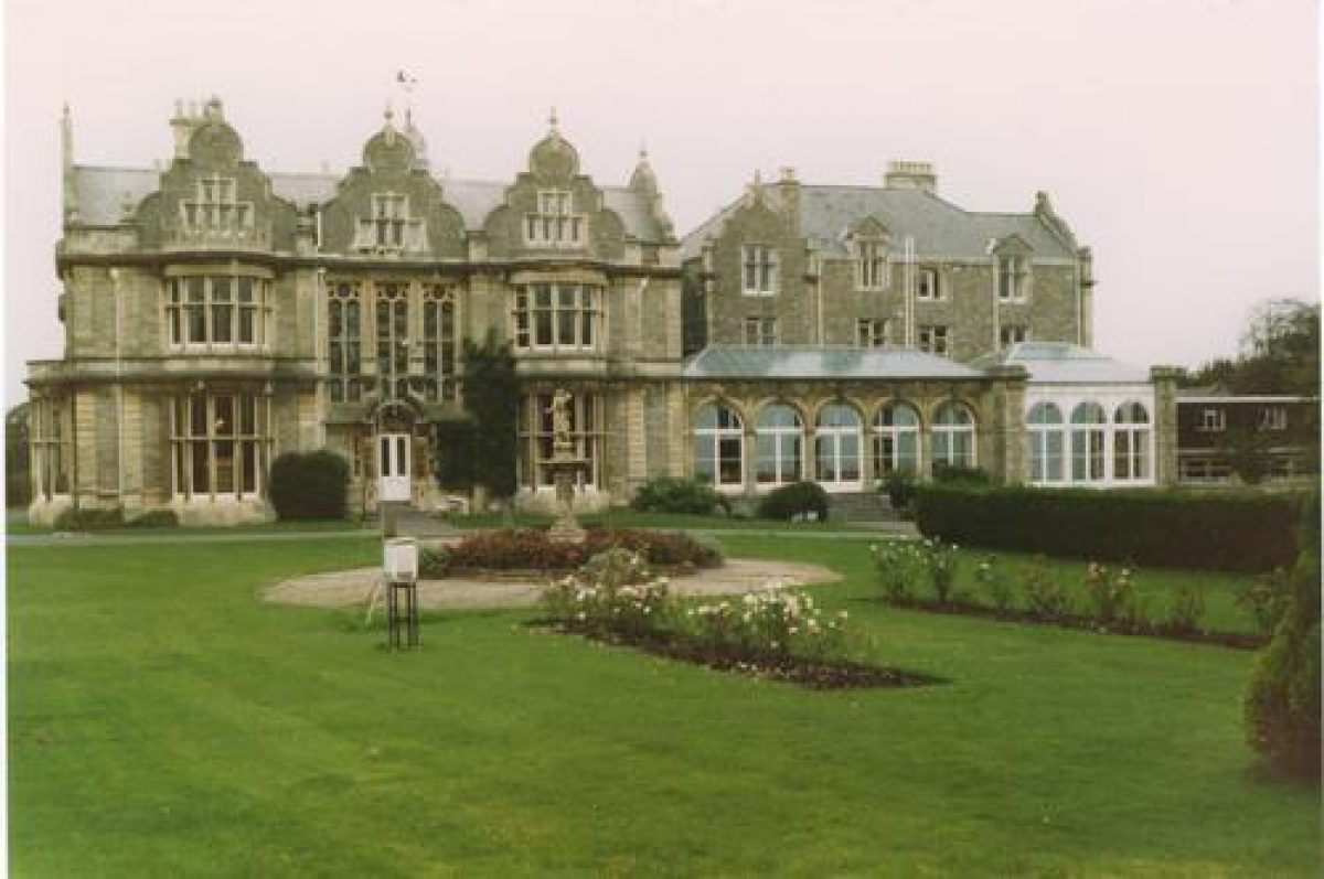
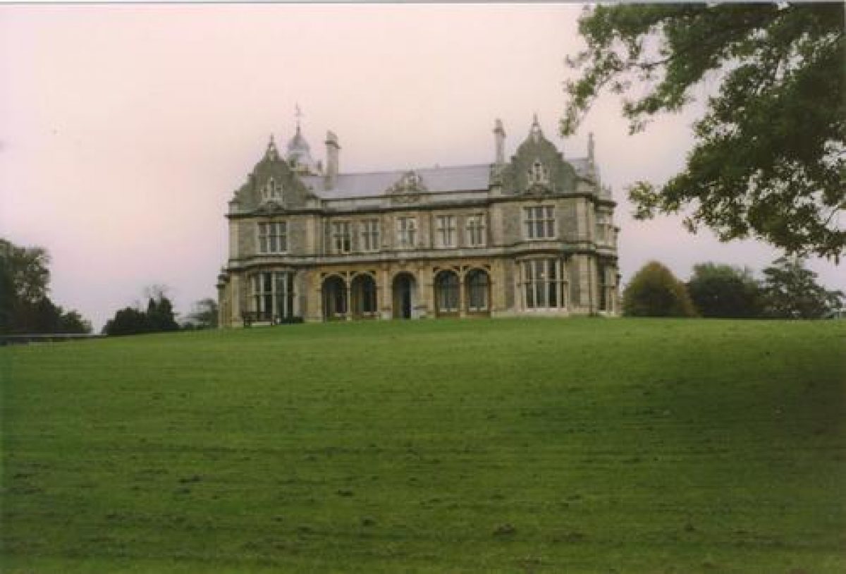
Clevedon Hall and its pleasure gardens date from the mid-19th century. At its most extensive the grounds within the boundary walls were approximately 8.5 hectares in extent with more than 12 hectares of parkland outside the boundary walls and running down to the Severn Estuary. The Hall is now in commercial use for weddings and corporate events, but is not open to the public in general.
Terrain
Flat
The following material was provided by the Avon Gardens Trust, and was researched in the 1980s:
Location, Area, Boundaries, Landform, Setting
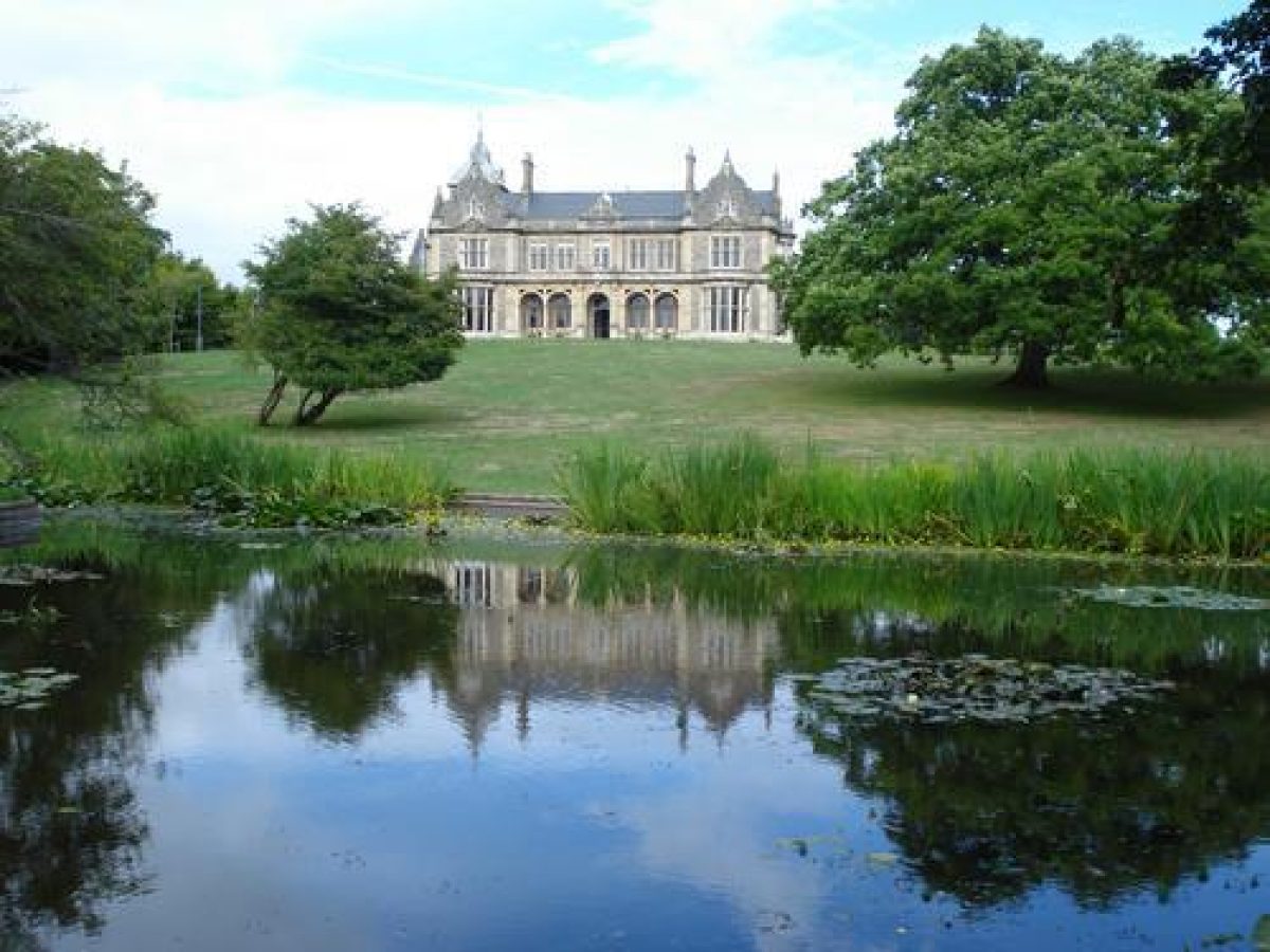
The grounds of Clevedon Hall are situated close to the sea front in Clevedon, occupying some 8 hectares of land. This small landscape park with formal and informal gardens is of typical mid-19th century layout, and was designed to complement the Hall as a country house in miniature. Whilst previously more extensive, the grounds surrounding the Hall still form its essential setting. Furthermore, the Hall and its grounds retain their important open aspect to the sea, due to the land to the west of Elton Road (once part of the parkland) being used as the public recreation ground for Clevedon.
Entrances and Approaches
The main entrance drive to the Hall from Victoria Road passes the lodge and leads in a gentle curve westwards before turning southwards to enter the forecourt in front of the Hall, giving views to the pleasure ground to the south and west. The drive has trees and woodland to either side of it which obscure direct views of the Hall until arriving at the front of the Hall.
To the south of the drive is the walled kitchen garden which is no longer in cultivation. A house has been built in the north-east part of it. The remainder of the walls of the kitchen garden are intact and are protected because they are a curtilage listed building as part of the listed status of the Hall.
To the north of the drive is an area of parkland, which was intended to be visible from the drive. This open space was more recently used for recreation purposes when St Brandon's School occupied the property.
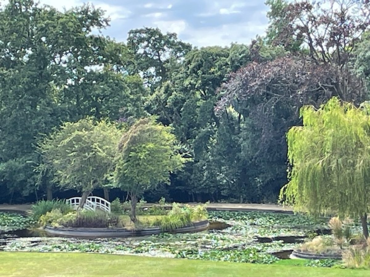
From the front of the Hall lawns lead down to an ornamental lake in the south-west corner of the pleasure ground. This has three small islands, which were restored in the 1990s and which are currently being enhanced (2010-11).
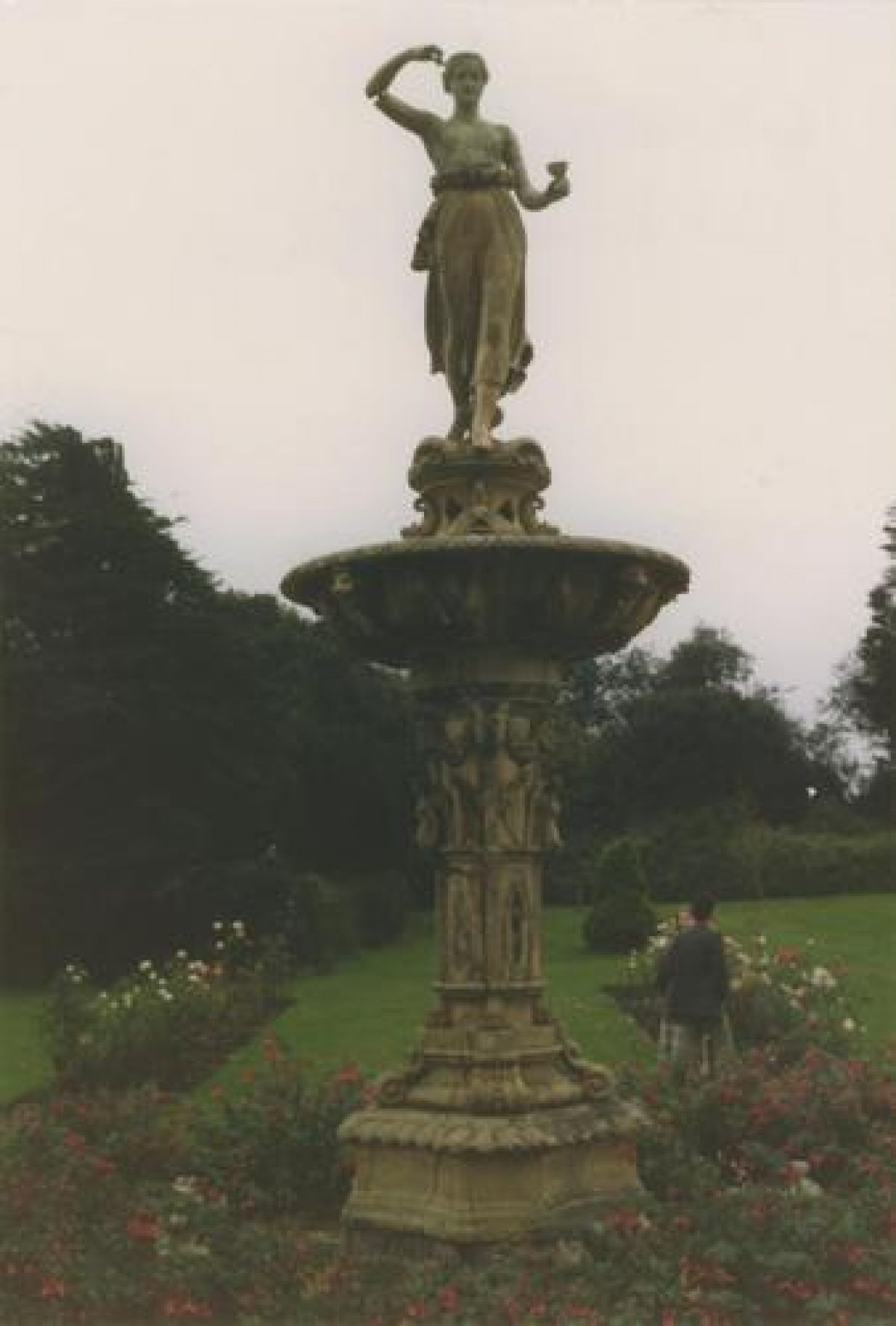
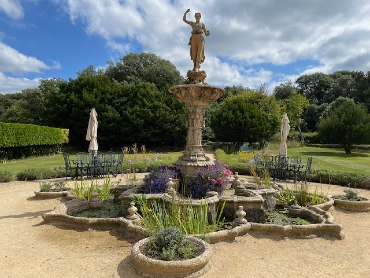
To the south-east of the Hall there is a fountain with a statue of Hebe, Greek cup-bearer to the gods. This is no longer working, but is also being repaired (2010-11). The formal flower garden to the east of it, and the terrace walk to the south, are no longer in existence.
Gardens and Pleasure Grounds
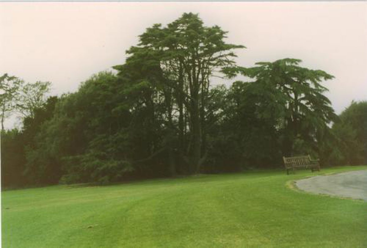
The woodland and shrubberies of the pleasure gardens are set around the south and west sides of the grounds. Evergreen trees in particular within these areas provide a valuable setting for the Hall when seen from Elton Road, the sea front and Old Church Road.
School buildings were erected in the latter half of the 20th century, both to the east of the Hall and adjoining Elton Road (where there is a secondary entrance to the grounds). There are also parking areas associated with these buildings.
Although three gardeners were being employed by St Brandon's School in 1985 the maintenance of the grounds of Clevedon Hall had declined in the post-war period.
In 1991 Clevedon Hall and the estate were purchased by the current owner. They were used until 2009 as a corporate headquarters, but in 2010 became available for private hire by businesses and private individuals. The grounds are currently undergoing a process of upgrade and maintenance.
Clevedon Hall is now a well established events and wedding venue (2021)
Description amended: November 2021
- Visitor Access, Directions & Contacts
Website
https://clevedonhall.co.ukAccess contact details
Clevedon Hall is an events and wedding venue.
Other Websites
- History
The following material is based upon recently discovered archive material:
19th Century
During the 19th century the Elton family of Clevedon Court was actively promoting the development of Clevedon. Land was donated by the Baronet for urban and community buildings and plots were sold for housing development.
Clevedon Hall (originally named variously Frankfurt and Frankfort Hall) was built for Conrad Finzel who, after arriving as a German émigré to avoid conscription into the army, built up the UK's largest sugar-refining business in the Counterslip Factory, Bristol. He became a successful and respected merchant and invented a centrifugal machine for removing moisture from crystallised sugar. The patent brought in £10,000 a year, and matched the amount Finzel gave to support George Muller's orphanages in Bristol.
It has previously been assumed that from its inception the Finzel estate stretched from Victoria Road to Elton Road and the grounds were designed and laid out to complement the Hall as a country house in miniature, with parklands, formal and informal gardens. The recent discovery of all the original Leases and Conveyances relating to Frankfurt Hall and surrounding land, in an unbroken chain from 1852 to the present day, prove conclusively that it was, in fact, designed to sit in a modest plot with access from Elton Road.
1852-1859
The original 10 acre estate of Mr Conrad Finzel the elder.
In December 1852, Sir Charles Abraham Elton Bt., leased three parcels of land to Mr Conrad Finzel the elder, with permission to build one or two villas thereon, together with a boundary wall, not later than 1st January 1856. Six acres of land were on The Hill and there were another 4 acres on the other side of the newly-built Elton Road that secured the view from the front of the house to the estuary. The leases were subsequently converted to purchases in 1853 and 1854. Bristol architects, J. Foster and J. Wood were commissioned to design a dwelling in a Jacobean-Revival style and the builders were Messrs. Baker and Co., of Bristol. The first buildings were Frankfurt Hall, and a small Lodge and Stable block in what was then the north eastern corner of the building plot. The house was positioned towards the north-east boundary with the garden falling away to the south and west.
There was a requirement to build a 40 foot road along the northern boundary from Elton Road at a point approximately 450-500 feet from the corner of Old Church Road, to connect to the 'lands of Sir Charles Abraham Elton Bt' that lay to the north and east of The Hill. The positioning of a Lodge adjacent to the Stables, which appears an anomaly these days, now becomes obvious. This Lodge appears on the 1861 Census with the Coachman, his wife and 6 children living there. (Clevedon Civic Society reference C103).
There is evidence on the 1851 Tithe Map of a north/south footpath or track linking The Beach and Old Church Road and running along what became the eastern boundary of the Hall, so it is possible this also gave access to the Hall. The boundaries around The Hill, as shown on the 1852 Leases, were Old Church Road to the south (some 600 feet), Elton Road to the west (around 500-600 feet), with Elton-owned land surrounding it to the north (437 feet annotated) and east (544 feet annotated). The boundary wall was built with two pedestrian gates: one on Old Church Road (still in use) and one on the corner opposite what is now the Salthouse Field (lintel still visible). There is evidence of what was probably part of the 1852 eastern boundary wall.
1859-1863:
Estate increased to 16 acres by Conrad William Finzel, the younger.
Following the unexpected death of Conrad Finzel, in 1859 while on a visit to Wiesbaden, his son Conrad William Finzel inherited the four-year old mansion and 10 acres of land. He increased the size of the estate to approximately 16 acres by buying a strip of land (1851 Tithe Map: part of plots 288,289,292,294,298, 299,) that connected to the newly-formed Victoria Road, together with a plot facing onto Victoria Road (1851 Tithe Map plot 300). These plots were tenanted agricultural land. C.W. Finzel was in partnership with John Payne Budgett Esquire, and together they built up jointly-owned land holdings adjacent to The Salt-house and Frankfurt Hall; this land was intended for building as there was a contractual requirement to pay £100 per house built.
1863-1877
Drive from Victoria Road created, kitchen and pleasure gardens laid out.
One of the tenancy agreements on the land connecting the house to Victoria Road did not expire until 1863 so the earliest formation of the carriage drive, Victoria Road lodge house and kitchen gardens can be accurately dated. The curve of the 1863 drive traces this newly-extended northern boundary for much of its length. The 1861 Census shows no gardeners in occupation, whereas the 1871 Census records a Head Gardener, with ‘7 men under him', living in a second Lodge near the gate, so it is most likely the gardens to the south side of Frankfurt Hall, and the tree-planting along the drive, were laid out between 1863 and 1871 by Messrs Garraway and Co., of Bristol.
Historic maps suggest the tree screen on the northern boundary of the drive was thickened up, possibly so that visitors using the post-1863 carriage drive did not glimpse the grand villas being built on the other side of Church Path (now known as the Donkey Path) and along Victoria Road. Other than a section adjoining Victoria Road, the land to the north of the drive was not part of the Frankfurt Hall estate. In 1867 C.W. Finzel assigned the deeds of his two houses and his share in the land-bank to John Payne Budgett as security for a £35,000 loan, followed by a further £14,000 loan in 1873. By 1876 C.W. Finzel was in serious financial difficulties.
1877-1900:
Estate bought by Charles Hill and increased to 54 acres by additional land purchases inside and outside of the boundary walls.
In 1877 the executors of John Payne Budgett (now deceased) amalgamated all of his property and land holdings in Clevedon, which included C.W. Finzel's mortgaged properties of The Salt-house and Frankfurt Hall, and offered them as one lot. It was bought by Charles Hill at a knockdown price of £30,000. The Sales Particulars published in ‘The Times' give detailed information about the grounds. (The lengthy descriptions of the houses have been omitted):
"Highly important Sale of exceedingly delightful Marine Residence comprising a noble, modern Family Mansion known as Frankfurt Hall, most substantially built in the Elizabethan style, approached from Victoria-road by a carriage drive of nearly a quarter of a mile in length, with entrance lodge, placed on a gentle eminence, facing the Bristol Channel, commanding land and sea views of great and varied beauty, with very spacious and elegant conservatory, 100 feet in length, surrounded by extensive lawns, most beautifully-arranged pleasure grounds, broad terrace walks, well-grown shrubberies, comprising the finest specimens, rosary, flower gardens, large ornamental lake stocked with fish and surround three miniature islands, splendid Hebe fountain, rustic summer-houses, one containing a camera obscura, 200ft of extremely well-built and exceptionally healthy early and late vineries, peach-house 50ft; orchard house 84ft; span-roof stove and intermediate house, pine and melon pits, cucumber and mushroom houses, all fitted with the latest and most costly improvements in heating and ventilation; extensive and very superior detached stabling for upwards of nine horses, carriage house, harness room, coachman's house, kennels, sheds and all necessary buildings; about three acres of most productive fruit and kitchen gardens, well stocked with the choicest trees and extremely rich pasture land extending to the beach, forming a residential property of rare beauty and magnificence distinguished for the possession of those comforts and attractions suggested and obtained by wealth and taste, and improved by years of most careful attention."
"An highly attractive Marine Residence, known as Salt-house, in an elevated situation, approached by a carriage drive through a fine avenue of trees, commanding lovely land and sea views, with prettily-arranged pleasure grounds, fountain in front of the house, croquet lawn, shrubberies, shaded walks, summer-house, or observatory, very productive kitchen gardens, orchard, piece of rich pasture land, good stabling, and a gardener's cottage. Also, two cottages with gardens, yard and exceedingly-desirable building land; the whole containing 70a. 1r.5p (more or less); most admirably situate commanding uninterrupted and magnificent views of the Bristol Channel and Welsh Hills, within five minutes' walk of the old Parish and other churches, about a mile from the station, and 35 minutes by rail from Clifton and Bristol."
The sale was completed on 21st December 1877 and, in what today would be called a back-to-back deal, Charles Hill sold the houses and land he did not want. He retained Frankfurt Hall and the acreage bounded by Victoria Road (eastern boundary), Old Church Road (southern boundary), Church Path (northern boundary) and Elton Road (western boundary), West Leaze and part of the Tyning on the seaward side of Elton Road, and about 14 acres of land on the inland side of what is now known as Southern Way. The total acreage was 54 a. 2r 1p. It was at this point that the field to the north of the carriage drive was incorporated into the estate. As the landscape of the grounds was fully formed and laid out, it is probable that this field remained in agricultural use as it was well-shielded from the carriage drive.
This historical evidence proves that 1877 was the point at which the renamed Clevedon Hall Estate was at its largest within the boundary walls, with a further and substantial acreage outside the walls. The boundary wall was extended along Elton Road and turned eastwards along part of Church Path (now known as the Donkey Path). The reason why the wall was not continued for the whole length of Church Path or along Victoria Road is not yet known.
A pathway from the carriage-drive was formed to lead to a pedestrian gate at the north-west corner. The 1882/3 Ordnance Survey 1st edition map shows the estate within the walls in its newly-established form and gives an indication of the layout of the gardens and landscaping commissioned by C.W. Finzel the younger in earlier years. Other than the 1897 purchase of a small plot of land to the south of the Victoria Gate Lodge House for the erection of two houses, the land area within the walls remained the same during Charles Hill's ownership. A photograph, taken from Church Hill in 1892, shows dense tree screening around the western boundary with a cleared area giving a fine view of Clevedon Hall's western elevations before the screening starts again further along the Elton Road boundary.
There are also a number of late-19th-century photographs in the Sales Particulars of the grounds and the lake. Photographs in the Francis Frith collection show the fine park-like pasture land, planted with mature trees, outside the boundary walls (now the Salt-house Fields). Following the death of Charles Hill, the estate was put up for sale. An extract from the 1900 Sales Particulars reads:
"Clevedon Hall Estate, facing the sea. Clevedon, Somerset. Plan, Particulars, Views and Conditions of sale of the Handsome Family Mansion know as Clevedon Hall, with Entrance Lodge, Detached Stabling, Coachman's House, Lawns and Pleasure Grounds, Fruit and Vegetable Gardens, Magnificent Conservatory, Glass Houses and Park-like Pasture Land containing together 54a 2r 1p (or thereabouts) most admirably situate, and commanding uninterrupted and splendid views of the Bristol Channel and the Welsh Hills, within five minutes' walk of the Old Parish and other Churches, and the Railway Station and about 35 minutes by rail from Bristol and about three hours from London. The Pleasure Grounds are extensive and beautifully arranged and comprise spacious lawns, tennis court, croquet grounds, shrubberies planted with finest specimens. Broad terrace walks, flower gardens, etc. In the grounds are a splendid Hebe fountain, a large ornamental lake with three Miniature Islands, two rustic summer houses, one with Stained Windows and a Camera Obscura. The Glass Houses which are situate at the rear of the Mansion include early, late and midseason Vineries, together about 200 feet in extent, in full bearing. Peach House 50 feet. Int., ditto 36 feet. Tomato House 24 feet. Span-roof Stove and Greenhouse 40 feet by 24 feet. Mellon Pits and Cucumber House. The Kitchen Gardens and Fruit Gardens are well stocked with the Choicest Trees, are in a high state of Cultivation and contain Bothy, Fruit Rooms, Potting Sheds, etc. The Stabling is exceedingly good, and detached from the House. It comprises 8 Loose Boxes and 1 Stall with Red Deal Fittings, large Carriage House, Lofts, Harness Room, enclosed and party covered Yard. Adjoining is a Coachman's House, containing 5 rooms; and there are also Cattle Sheds, Dog Kennels, with Boiler House, and other useful Outbuildings. The Mansion and about 20 Acres immediately around it are almost entirely bounded by Victoria Road, Elton Road and Old Church Road. The Pasture Land is of deep rich quality and extends to the Beach."
20th - 21st Century
1900-1932:
Clevedon Hall Estate reduced to around 20 acres within boundary walls.
The 1903 Ordnance Survey map indicates a small plantation in the north-west corner with an adjacent Pheasantry, which does not appear on either the 1884 Ordnance Survey 1st Edition map or the 1908 Conveyance plan so it was a short-lived feature. This could have been present in Hill's day as a chick-rearing enterprise or as an ornamental aviary, or it might have been a later venture as Clevedon Hall remained unsold, although occasionally tenanted, until it was put up for sale (as 3 lots) on 22nd October 1907. One lot, all within the boundary walls, was purchased in 1908 by its tenant, E. A. Trapnell Esq., with a land acreage of 20a 1r 9p or thereabouts for the sum of £8,000. The 1908 Conveyance Plan is similar to that in the 1877 Conveyance, so little had changed in the grounds in 30 years.
Following Mr.Trapnell's bankruptcy, The London and Provincial Bank took possession in 1913 and the Reverend Harold Nelson Burden and Mrs Katherine Burden took a ten year lease from June 1913. The Bank was voluntarily wound up on 2nd October 1918 and the Burdens purchased Clevedon Hall from the Liquidator on 28th October 1918. In 1926 they transferred ownership to Stokes Croft Estates and took out a 33 year lease at a rent of £150 per year.
Katherine Burden died in 1919 and within the year Harold married Rosa Williams, the first superintendent of Stoke Park Colony, a National Institution for Persons requiring Care and Control due to mental handicap and neurological problems. While the Burdens were in residence Clevedon Hall changed from a home to institutional use in that it was used to give residents of Stoke Park a holiday working in the grounds, gardens and kitchen gardens and learning domestic service. A number of Victorian buildings in the service courtyard shown on various conveyances and Ordnance Survey maps were demolished so that a large extension could be built on the eastern side of Clevedon Hall, more than doubling it in size. Harold Burden died in May 1930.
1932-1945:
Salisbury Farm added to estate increasing the size to 26 acres.
In 1932 Rosa Burden purchased Salisbury Farm, on the southern boundary, leasing it back on the same day to the farmer, William Thomas Tinklin, for a rent of £120 per annum. Rosa Burden lived and continued her work at Clevedon Hall until her death but before her Executors could finalise a sale the Hall was requisitioned and used as offices by the Bristol Aerospace company. An annexe in the Hall was used to educate boys from Bristol Technical School who were evacuated to Clevedon from 1941 to 1944. Nissan huts, an air-raid shelter and a mess hut were erected, along with a Toc H meeting hut and a Red Cross Station. The field to the north of the carriage drive was used for barracks for the US army, while the officers were billeted in a hotel on the nearby Wellington Terrace. It is likely that the gate in the Elton Road boundary wall was widened for vehicular use at this time and a driveway formed along the line of an existing path. There is a report concerning officers' cars being seen driving along Elton Road to get from the hotel to Clevedon Hall, and also a report of a fatal accident when an evacuee from Guernsey was killed by an American vehicle outside this gate.
1945-1991:
Clevedon Hall Estate reduced to approximately 17 acres through land sales on southern and eastern boundaries.
In 1945 Clevedon Hall was purchased by The Trustees of The Clergy Daughters' School, an independent girls boarding school that had started life in 1831 at Benton Street, Gloucester, moved in 1833 to St Michael's Hill, Bristol; then to Great George Street, Brandon Hill, Bristol in 1862 and been evacuated to the Bishops Palace in Wells, Somerset, during World War 2. Incorporated into one of the Elton Gate pillars is a stone tablet that reads "St Brandon's School 1904", believed to have been brought from Bristol, commemorating the name adopted by the school in that year.
Land adjacent to the drive and some of the land that had belonged to Salisbury Farm was sold off on the same day as Clevedon Hall was purchased, with sufficient retained to create a sports pitch. Many school buildings were erected in the four decades that followed, clustered around the immediate environs of the Hall and most of which remain. A new Junior School building was erected in 1971, (extended in 1978 and 1989), on the Elton Road frontage in an excavated area marked ‘Tennis Lawn' on the 1883 Ordnance Survey map 1st edition. About one third of the field to the north of the former carriage drive was used for a sports hall, swimming pool, ancillary buildings and car parking; one third was levelled for six hard-surfaced tennis courts and the remainder was levelled for a sports pitch, forming a steep bank with a 2 metre drop across the width of that area.
In 1969 the area of land alongside Victoria Road, (originally incorporated into the estate in 1863), was sold and the Pyne Point housing estate built. In 1982, a strip of land running along Old Church Road and formerly part of Salisbury Farm was sold for housing development. In 1971 a house was built in the north east corner of the walled kitchen garden.
1991-2011:
In 1990 The Trustees of Clergy Daughters' School were in financial difficulties. Following dispersal sales in September 1990 and January 1991, 6 ownerships were established: Clevedon Hall with land to the south of the drive; the Junior School with land to the north of the drive (closed 2004); The Stable Block (commercial); The Lodge (private house); The Wall House (private house); Shearwater House (commercial). The Hall was used as commercial offices until 2009; in 2010 it re-opened as a venue available for weddings, corporate and private events. There is no public access and no rights of way through the estate.
Additional Research
The following material was provided by the Avon Gardens Trust, and was researched in the 1980s:
Clevedon Hall (originally named Frankfurt Hall) was built in 1850 for Conrad Finzel, an extremely successful, German sugar merchant based in Bristol who made his fortune by inventing a vacuum device for evaporating moisture from sugar. The Hall was designed by J. Foster and J. Wood in an essentially Jacobean-Revival style, and is a quintessential example of a large suburban villa designed to approximate a country house in miniature.
The land for the Hall and its estate was purchased from the Elton family of Clevedon Court who were actively promoting the development of the town as a high-class resort. When Elton Road had been cut through the area, Conrad Finzel bought the land to either side of it. The estate stretched from Victoria Road in the north (where the entrance lodge was situated) to the Bristol Channel at Salthouse Bay, and to land to the south of Old Church Road.
The landscaped parkland was designed and laid out to complement the Hall as a country house in miniature, and was in typical mid-19th century style, with both formal and informal elements combined. Following the death of Conrad Finzel in 1859, his son C.W. Finzel succeeded him, occupying the Hall and maintaining the gardens and the pleasure grounds. Photographs taken in 1872 show the front (south-west elevation) of the Hall, and in the foreground the ornamental lake (with its three islands and a fountain) being enjoyed for boating. However, in 1876 C.W. Finzel was declared bankrupt.
Charles Hill J.P., a successful Bristol shipbuilder, bought the estate in c 1876 and re-named the mansion Clevedon Hall. By the time of the survey in 1882-3 for the Ordnance Survey 1st edition map the estate was fully developed. On Charles Hill's death in 1900 the 54 acre estate was sold. The 1900 sale particulars, which include photographs and a plan of the estate, give considerable detailed information about the Hall, its outbuildings, gardens, pleasure grounds and parkland.
The sale particulars referred to it as a "Handsome Family Mansion known as Clevedon Hall most substantially built in the Elizabethan style, approached from Victoria Road, Clevedon by a Carriage Drive of nearly a quarter a mile in length, delightfully situate on an eminence overlooking Salthouse Bay, commanding uninterrupted and splendid views of the Bristol Channel, the Welsh Hills, and the surrounding picturesque country with Attractive Entrance Lodge, containing 5 Rooms and Offices, Stabling, Coachman's House, Lawns, Pleasure Grounds, Ornamental Lake, Fruit and Vegetable Gardens, Conservatory, Glass Houses, and Park-like Pasture Land, the whole comprising an area of 54a.2r.1p. or thereabouts." The Pleasure Grounds are very extensive, and beautifully arranged and comprise spacious lawns, tennis court, croquet grounds, well-grown shrubberies planted with the finest specimens, broad terrace walks, flower gardens, etc. In the grounds are a splendid hebe fountain, large ornamental lake with three miniature islands, two rustic summer houses, one, with stained windows, containing a camera obscura. The Glass Houses which are situate at the rear of the Mansion, include early, late and mid-season vineries, together about 200 feet in extent, in full bearing, peach house 50 feet, late ditto 56 feet, tomato house 24 feet, span-roof stove and greenhouse 40 feet by 24 feet, melon pits and cucumber houses. The Kitchen and Fruit Gardens are well-stocked with the choicest trees, are in a high state of cultivation, and contain bothy, fruit rooms, potting sheds, etc."
The 1903 revision of the Ordnance Survey map confirms how Charles Hill had left the estate at his death.
By 1910 the Hall was lived in by Edward Trapnell, who was still in occupation in 1914.
In 1914, it is believed, the Rev. Harold Nelson Burden purchased the Hall as his private residence. He and his first wife Katherine were interested in the care of inebriates and mentally defectives, and provided much of the early residential care for these people before the end of World War I. His 'Colony' system of national institutions for the mentally handicapped were established in a string of country houses that had failed to reach their reserve prices at auction. The Burdens set up the first Colony in the country in 1909 at Stoke Park in Gloucestershire. Part of Clevedon Hall was used by them as 'holiday home' accommodation for residents of Stoke Park. Quickly outgrowing Stoke Park the Colony expanded before World War I into Leigh Court, Heath House, Stapleton Grove and Hanham Hall. Harold Burden died in 1930 but his second wife Rosa continued to live at Clevedon Hall until her death in 1939. The contents of the Hall were sold in 1941. During World War II the Hall was used as offices by the Bristol Aeroplane Company.
The Ordnance Survey map of 1930 shows that the parkland between Elton Road and Salthouse Bay had been sold and had become the recreation ground for Clevedon, with tennis courts, a putting green and lavatories. The parkland to the south of Old Church Road had also been sold and had been residentially developed. By 1930 the Clevedon Hall estate had therefore been reduced to the grounds surrounding the Hall itself, bounded by Victoria Road, Elton Road and Old Church Road.
In 1945 Clevedon Hall was purchased by St. Brandon's School For Girls, an independent girls boarding school. Under this ownership school buildings were erected in the grounds both to the east of the Hall and adjoining the Elton Road frontage, and part of the parkland was used for tennis courts and playing fields. An area of parkland north of the drive and adjoining Victoria Road was sold for housing development (now built as Pyne Point). A smaller area to the south of the drive was also sold for housing (becoming the end part of the cul-de-sac West Way.
A house was also built on the north-east part of the walled kitchen garden (known as The Wall House). In 1991 the School had incurred debts of about £1 million and its senior school was forced to close. A Clevedon-based business consortium then bought the Hall and part of the grounds for £1.5 million. With this funding the School continued as a Junior School in buildings adjoining Elton Road, but the Junior School has also now closed leaving its buildings vacant. The hall was, until 2009, used as commercial offices and in 2010 became available for business and private events.
Description amended: October 2010
Period
- Post Medieval (1540 to 1901)
- Victorian (1837-1901)
- Features & Designations
Designations
The National Heritage List for England: Listed Building
- Reference: Boundary wall to the south, west and north of the grounds
- Grade: II
The National Heritage List for England: Listed Building
- Reference: Clevedon Hall
- Grade: II*
The National Heritage List for England: Listed Building
- Reference: Fountain in the grounds to the south of Clevedon Hall
- Grade: II
The National Heritage List for England: Listed Building
- Reference: Lodge at the north entrance
- Grade: II
The National Heritage List for England: Listed Building
- Reference: Outbuilding in the range to the north of Clevedon Hall
- Grade: II
Features
- House (featured building)
- Description: Large Mansion designed by J.Foster and J.Wood in essentially Jacobethan-Revival style for Conrad Finzel, and built between 1852 and 1855. It gradually grew into a substantial villa set in walled grounds with additional parkland beyond.
- Earliest Date:
- Latest Date:
- Drive
- Description: The carriage drive of almost a quarter of a mile in length leads from the principal gate at Victoria Road, passing the entrance lodge and continuing westwards on a gentle curve. It then veers to the south through a dense belt of tree planting to reach the forecourt of the Hall and the pleasure ground to the west and south-west of it. The drive passes through a changing, spacious landscape, coiling around the Hall to create the maximum sense of space within the available site. The whole approach was carefully designed to approximate the spacious, sweeping approach to a country house.
- Earliest Date:
- Latest Date:
- Kitchen Garden
- Description: The walled kitchen garden is situated to the south of the entrance drive. It was divided by paths into four squares and had a sun-dial at its centre. There were lean-to greenhouses on the south-facing wall. There are a number of gateways into the kitchen garden. In 1971 a house was built in the north-east corner and the remainder used as a donkey pasture for many years. The glasshouses fell into disrepair and were demolished. The orchard house, vineria, melon pits, cucumber pits and other buildings mentioned in the 1900 Sales Particulars have long since disappeared, although there is some evidence remaining of the buildings built onto and over the kitchen garden walls, namely ventilation openings and doorways.
- Earliest Date:
- Latest Date:
- Ornamental Fountain
- Description: An ornate stone fountain is situated to the south side of the Hall and was originally on a path which led down to the edge of the southern tree belt. The paths in this area have been grassed over. The fountain is a copy, possibly two thirds scale, of The Hebe Fountain by James Pulham, who won an award for this design at the 1862 Great London Exposition. The original Hebe Fountain is installed at Dunloran Park, Tunbridge Wells. The Clevedon Hall fountain has a tall circular stem supporting a bowl with a central pedestal and a carved female figure (in Grecian style and depicting Hebe, cup-bearer to the gods) stepping forward on top. It has carved dolphins to pedestal with angels and lion masks to the underside of the bowl. The stem of the fountain has angels and centaur heads with swags. There is scrollwork to the base. The basins at the foot of the fountain have sides shaped in ogee curves and are now used as flower beds. Phased restoration work is in progress.
- Earliest Date:
- Latest Date:
- Ornamental Lake
- Description: A man-made ornamental lake is situated in the south-west corner of the pleasure grounds, visible across the lawn that slopes down from the front of the Hall. Described in documents variously as a Fish Pond, Japanese Pond and a Water Garden, the lake has a curved shape reflecting its situation in the curved south-west corner of the grounds. The lake has three islands which photographs taken in 1872 show as having trees and other planting on them. On one of the islands there is an ice house. Remnants of underground pipe-work have been found that indicate the water level was topped up from run-off water from the Hall's roofs and these pipes may have been part of a hydraulic system to provide flow to a fountain shooting water some 15 feet high. Photographs taken around 1890-1897 show water lilies and other plants in the lake and lush ornamental planting around its margins. The lake was enjoyed for boating, using a small rowing boat, as is evidence by historical photographs. The lake was restored and restocked with fish in the 1990s.
- Earliest Date:
- Latest Date:
- Tree Avenue
- Description: The creation of the carriage drive can be accurately dated to after 1863, after the expiry of tenancies on that area of land. It is almost a quarter of a mile long and leads from the principal gate at Victoria Road, passing the entrance lodge on the left, and continuing westwards on a gentle curve. It veers round a dense belt of trees and runs southwards through a grassed area to reach the forecourt of the Hall, with views over the lake and pleasure ground to the west and south west on the approach to the Hall. Historical maps show the majority of the drive was designed and planted on either side with trees, which are now mature. There is evidence that the northern edge of the drive, which was the boundary until 1877, was more thickly planted, allowing only glimpses to the agricultural land beyond and screening new villas on Elton Road and Victoria Road on the outward journey. The avenue of trees also obscured direct views of the Hall until the last minute thus increasing the sense of anticipation, although glimpses of the tower might have been possible. The area to the south of the drive which contained the more utilitarian areas of the estate, such as the walled kitchen garden, the stables and the service court would also have been screened by these trees. The drive still enters by Victoria Road (in traffic only since 1991) and runs along its original line to Clevedon Hall. At some point (probably 1939 or thereabouts) it was extended and widened along the line of an earlier pathway to Elton Road (in and out traffic). The historic 1863 tree-lined drive although degraded by adjacent fences and with significant gaps on both sides still exists in a clearly readable form today.
- Earliest Date:
- Latest Date:
- Wilderness
- Description: Woodlands and shrubberies were planted on the north, west and south sides of Frankfurt Hall, with a belt of trees along the frontages to Old Church Road and Elton Road, the latter having a large gap, evidenced in photographs taken from Church Hill in 1897, so the western elevation of the Hall could be seen. Although there are a number of deciduous trees, evergreen trees are in the majority and much of the planting survives today. A number of pathways through the grounds are evidenced by the plans in early 20th century Conveyances and Ordnance Survey maps but most are not discernible today.
- Earliest Date:
- Latest Date:
- Planting
- Description: On the south side of the drive, and between it and the wall of the kitchen garden, is a sunken area about a metre lower than the level of the drive containing a designed Water Garden. There is a large, oval, raised stone-walled ornamental pond with the remains of paving surrounding it. This area is currently heavily overgrown.
- Planting
- Description: Cartographic and photographic evidence shows that to the south of the Hall and adjacent to the fountain, were formal and informal pleasure gardens, with pathways, pergolas and rustic summerhouses. A large car park is currently situated here.
- Earliest Date:
- Latest Date:
- Tree Feature
- Description: To the north of the drive was an area of established agricultural land which was not incorporated into the Clevedon Hall Estate until 1877. On the Ordnance Survey 1st edition map of 1883/4, a small densely-planted copse is shown immediately to the north of the Victoria Gate with an established belt of trees along the southern edge of this field (the edge of the carriage drive) and curving into the north-west corner. A plantation is indicated in the seaward end of the field on the east side of the tree belt, and a small circular copse is shown about two thirds of the way along the northern boundary near Church Path (now known as the Donkey Path). Along the eastern boundary, a clearly-defined broad avenue of widely-spaced trees is marked, running parallel to Victoria Road. The field to the north of the drive is described as "Field" in the Sales Particulars of 1900 (it correlates to Tithe Map numbers part of 287 and part of 300). It is not the `park-like pastureland' referred to in the 1900 Sales Particulars: that is the 30-35 acres on the seaward side of Elton Road and off Southern Way. (Tithe Map 497, 502, 505, 506, 507). Aerial photos taken in 1925 suggest a standing crop (hay or corn) is being grown on the field: the circular copse is still visible, as is the avenue of trees parallel to Victoria Road. The copse is visible in 1946 (RAF aerial photograph F/20.//82SQDN, 4086). About 4 acres of the eastern section now comprises the Pyne Point housing estate. The remainder is currently in a degraded state with 6 tarmac-surface tennis courts, a substantial sports hall and two large areas of hard-standing for parking, as well as a man-made plateau for a grassed sports pitch, the whole area having been levelled in the mid-twentieth century. Modern planting has been carried out to the north and east boundaries, with a conifer tree screen to the west of the tennis courts.
- Earliest Date:
- Key Information
Type
Park
Purpose
Ornamental
Principal Building
Commercial
Period
Post Medieval (1540 to 1901)
Survival
Extant
Hectares
8.1
Open to the public
Yes
Civil Parish
Clevedon
- References
References
Contributors
E.T. Thacker
Avon Gardens Trust
Susan Vesey