Introduction
Burngreave Cemetery was opened by the Brightside Burial Board. The buildings are by William Flockton & Son of Sheffield. The cemetery occupies an elevated site within a valley which rises to the north-east with fairly steep sides. There are good views of the city centre, the Don valley and beyond. Features include a pair of gate lodges in Jacobean revival style, a war memorial and paired chapels.
Terrain
The cemetery occupies an elevated site within a valley which rises to the north-east with fairly steep sides.The following is from the Register of Parks and Gardens of Special Historic Interest. For the most up-to-date Register entry, please visit the The National Heritage List for England (NHLE):
www.historicengland.org.uk/listing/the-list
Opened in 1860, Burngreave Cemetery was one of the first public cemeteries to be established in Sheffield. The principal buildings were designed by the local architects, William Flockton & Son.
Location, Area, Boundaries, Landform and Setting
Burngreave Cemetery is situated c 1.75km north-north-east of Sheffield city centre in the suburb of Pitsmoor and occupies a roughly rectangular area of c 14.5ha, enclosed within stone walls. It is bounded to the north-east by the back gardens of C20 houses built on former college playing fields, and the back gardens of terraced houses along the south-west side of Scott Road. The south-east boundary is formed by the back gardens of houses on Malton Street, school grounds, and an adventure playground. The south-west boundary is formed by the back gardens of houses on the north side of Melrose Road. To the west are the back gardens of houses on the east side of Burngreave Road while to the north-west the boundary is defined by the back gardens of houses on Holtwood Road and Abbeyfield Road.
The cemetery occupies an elevated site within a valley which rises to the north-east with fairly steep sides. Good views are afforded from the valley floor towards the south-west and the city centre. Views from the north-west side of the cemetery are largely obscured by tree growth except for the south-west corner, where the ground dips towards the cemetery chapels, affording excellent views of the chapels and the city beyond. The south-east side of the cemetery rises to a crest beyond which the ground slopes down towards the south-east boundary. Here, where the cemetery is less densely planted, good views are afforded south-west towards the cemetery chapels and the city centre, and to the south, south-east, and east over the Don valley and beyond.
Entrances and Approaches
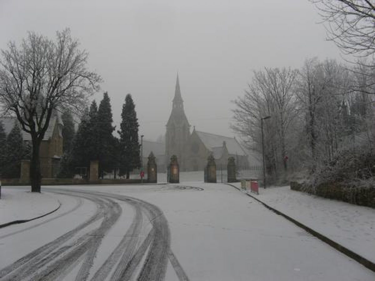
The approach to the principal entrance, which dates to 1860-1, is from Burngreave Street to the south, a tree-lined road of late Victorian and Edwardian housing. This entrance can also be reached from Melrose Road situated south of the cemetery. Consisting of a central carriage entrance with pedestrian access to either side, the four stone gatepiers (listed grade II) have gabled tops with pyramidal caps and crocket finials. There are three pairs of cast-iron gates and, beyond the gate piers, cast-iron railings on a chamfered stone plinth. Beyond these, to either side, short boundary walls link to the two lodges. The entrance is situated in the lowest part of the cemetery, the ground rising gradually towards the chapels. A second entrance, created c 1900 when additional land was acquired by Sheffield Corporation, is situated on the north-east boundary with access off Scott Road. It consists of a carriage entrance with pedestrian access on the south-east side, with three stone gate piers and cast-iron gates.
Principal Buildings
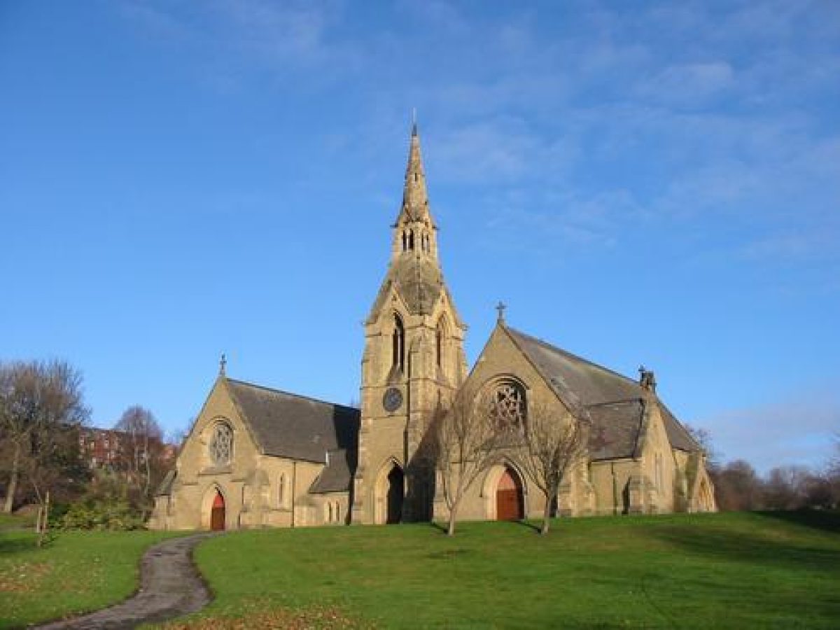
The cemetery chapels (listed grade II) stand 80m north of the principal entrance oriented towards a south-westerly aspect. Designed by William Flockton & Son, the layout of the buildings is symmetrical with a central tower, spire, and archway joined by single-storey links to the chapels which have large side vestries and porches. Built of coursed rubble and dressed stone with ashlar dressings and slate roofs, the chapels and adjoining tower are in the Gothic style. Above the central moulded archway is a clock and bell stage surmounted by a spire with a tapering square base surmounted by a square bell turret. Above the turret is an octagonal needle spire topped with a cross. The buildings are an important focal point seen from the approaches, the principal entrance, and from many parts of the cemetery. The spire is also a significant landmark within the city. The buildings are no longer in use, boarded up for protection (2001).
Situated c 10m west of the principal entrance is a lodge, formerly the superintendent's house, also designed by William Flockton & Son and built 1860-1. It is in Jacobean Revival style in coursed square stone and ashlar, with slate roofs. A smaller lodge (listed grade II), formerly the sexton's house, is situated 25m north-east of the principal entrance; this is a simpler version of the same style. Recently re-roofed and refurbished, both lodges are leased to the North Sheffield Housing Association and are currently occupied (2001).
Other Land
The main carriage drive leads north-west from the principal entrance, passing the former superintendent's house. A curving pedestrian route commences 30m north of the entrance leading uphill to the forecourt of the chapels. This route presently (2001) runs through an area of well-maintained grass slopes and tree planting providing an open setting for the chapel buildings and forecourt. The main carriage route continues uphill to the north-west, passing a brick building (C20) used for storing maintenance equipment, then turns eastwards to reach the wide, level tarmacked forecourt of the cemetery chapels. Proceeding to the north-east, through the archway or porte-cochère joining the chapels, the cemetery grounds come into view.
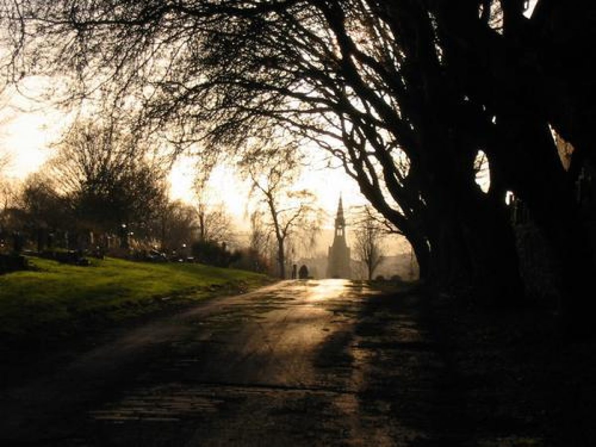
The main avenue, 6.5m wide, leads from the chapels directly and fairly steeply uphill in a north-easterly direction providing a strong spine to the layout of the cemetery. The axial relationship of this route with the chapel buildings is emphasised by the topography, the route following the floor of a former valley, the valley sides rising steeply to the north-west and slightly less steeply to the south-east. The two sections of the cemetery on either side of the main avenue are served by a rectilinear grid of paths. The north-west section is informally, and, in parts, closely planted with groups of trees including rowan, birch, sycamore, and lime. Here the groupings of graves are dense, with more elaborate monuments occupying elevated positions. Persistent drainage problems caused by issuing streams remain a problem (2001) in some parts. The south-east section of the cemetery has a more open aspect, with well-spaced plantings of deciduous tree specimens.
Presently tarmacked (2001), the original stone setts of the main avenue can be seen in parts just below the surface. To either side of the main avenue, beyond a 5m wide strip of grass stand rows of headstones which reflect the symmetrical layout typical of this part of the cemetery. An avenue of trees (OS 1889), affected by Dutch elm disease in the late-1980s, has been removed, as have holly and rhododendron specimens which formed regular groupings up the length of the main avenue (Friends of Burngreave Cemetery pers comm, 2001). Almost all the stone surrounds have also been removed for ease of maintenance.
Two paths intersect the main avenue at right angles 280m north-east of the principal entrance, one leading steeply uphill to the north-west and the other leading uphill to the south-east, forming part of the rectilinear grid pattern adopted by the Burial Board in the cemetery layout. Further uphill along the avenue, 380m north-east of the principal entrance, is another path intersection, this path running adjacent to the north-east boundary of the first phase of the cemetery. The slope levels off 385m north-east of the main entrance at a circular area of grass with several graves around its perimeter. In the centre of the circular area, reached by two short paths (OS 1905), is the space formerly occupied by a small wooden gazebo or summerhouse (now gone, 2001).
The avenue proceeds uphill from the circular area towards the Scott Road entrance, lined by a row of mature London plane trees on its north-west edge. The line of a former path leading off to the north-west is now grassed over (2001). The line of a footpath link to the south-east (OS 1905) is no longer in evidence. A diagonal path leads uphill to the east-north-east to the war memorial (erected c 1920, listed grade II), thought to have been designed by Sir Reginald Blomfield (1856-1942), 490m north-east of the principal entrance. Situated on the crest of the slope, excellent views are afforded from the war memorial to the west and south-west across the cemetery, and to the south, south-east, and east across the city, the valley of the Don, and beyond.
REFERENCES
Pawson & Brailsford, Illustrated Guide to Sheffield (1862), 72-4
Francis White & Co, Directory of Sheffield (1862)
Pawson & Brailsford, Sheffield and Neighbourhood (1889), 70
Harman R, Four Sheffield Cemeteries, (Victorian Society, South Yorkshire Group 1989)
Maps
Plan, Burngreave Cemetery Added Portion, 1912 (Sheffield Local Studies Library)
OS Old Series 1" to 1 mile, published 1855
OS 6" to 1 mile: 1st edition published 1894; 2nd edition revised 1901-3, published 1906
OS 25" to 1 mile: 1st edition published 1889; 2nd edition published 1905; 1935 edition
Archival items
City of Sheffield, Burngreave Cemetery Added Portion: Tables of Burial Fees and particulars of extra and optional fees, 1912 (Sheffield Local Studies Library)
S Welsh, William Flockton Architects (unpublished notes), 1963 (Sheffield Local Studies Library)
Contact Magazine [Christ Church, Pitsmoor parish magazine], (Sept-Oct 1981), 13-14 (Sheffield Local Studies Library)
Views of Sheffield, photograph album, nd, 26 (Sheffield Local Studies Library)
REASONS FOR DESIGNATION
Burngreave Cemetery is designated at Grade II for the following principal reasons:
* A good example of a High Victorian (1859-60) public cemetery for a provincial town informal grid-pattern style complimented by later C19 extensions in similar style.
* The buildings were designed by local architects, William Flockton & Son.
* The linked Gothic chapels form a striking focal point in the design dominating the main axis, set at the bottom of a gentle valley and heralded by the Superintendent's house and lodge flanking the main entrance.
* Social interest is expressed in a variety of C19 monuments, most of which are relatively modest.
* The cemetery layout and structures survive intact, together with planting including many trees from the C19.
Description written: October 2001
Amended: November 2001
Edited: December 2009
- Visitor Access, Directions & Contacts
Access contact details
This is a municipal site for general public use. Please see: https://www.sheffield.gov.uk/caresupport/bereavement/burial/cemeteries.html
Owners
Sheffield City Council
Town Hall, Pinstone Street, Sheffield, S1 2HH
- History
The following is from the Register of Parks and Gardens of Special Historic Interest. For the most up-to-date Register entry, please visit the The National Heritage List for England (NHLE):
www.historicengland.org.uk/listing/the-list
HISTORIC DEVELOPMENT
Burngreave Cemetery, constructed 1859-60, was one of the first public cemeteries established in Sheffield, provided and managed by the Brightside Burial Board for the township of Brightside Bierlow. Some 27 acres (c 11ha) of land formerly occupied by Burn Greave Wood and land used for gravel pits and mine shafts was bought at an initial cost of £5400 with a further £11,600 spent on the grounds, which were laid out in a rectilinear grid of paths, and on the building of chapels and lodges. William Flockton & Son of Sheffield designed the buildings which comprise two mortuary chapels, one for the Church of England and the other for Nonconformist use. On 16 March 1861 the Archbishop of York consecrated one chapel and about two thirds of the cemetery for Anglican use. Two lodges were built, one as a residence and office for the superintendent and the other as a house for the sexton. In 1900 Sheffield City Council took over the administration of the cemetery. By 1905 adjoining land to the north-east had been purchased, extending the cemetery by a further 9 acres (c 3.5ha) (OS 1905; Plan, 1912) and a new entrance and lodge were built on the south side of Scott Road. By the early-1980s the cemetery had become largely overgrown and works were carried out to 'improve' the cemetery for public use, including the removal of many stone surrounds and some monuments. The cemetery is today (2001) maintained by Sheffield City Council Bereavement Services and supported by a recently (late-C20) formed local Friends group.
Period
- Post Medieval (1540 to 1901)
- Victorian (1837-1901)
- Features & Designations
Designations
The National Heritage List for England: Register of Parks and Gardens
- Reference: GD5082
- Grade: II
Features
- Gate Lodge
- Description: A lodge, formerly the superintendent's house, also designed by William Flockton & Son and built 1860-1. It is in Jacobean Revival style in coursed square stone and ashlar, with slate roofs.
- Earliest Date:
- Latest Date:
- Entrance
- Description: Consisting of a central carriage entrance with pedestrian access to either side, the four stone gatepiers (listed grade II) have gabled tops with pyramidal caps and crocket finials. There are three pairs of cast-iron gates and, beyond the gate piers, cast-iron railings on a chamfered stone plinth.
- Earliest Date:
- Latest Date:
- Entrance
- Description: The principal entrance consists of a central carriage entrance with pedestrian access to either side, the four stone gatepiers (listed grade II) have gabled tops with pyramidal caps and crocket finials. There are three pairs of cast-iron gates and, beyond the gate piers, cast-iron railings on a chamfered stone plinth.
- Earliest Date:
- Latest Date:
- Entrance
- Description: A second entrance consists of a carriage entrance with pedestrian access on the south-east side, with three stone gate piers and cast-iron gates.
- Earliest Date:
- Latest Date:
- Chapel (featured building)
- Description: Built of coursed rubble and dressed stone with ashlar dressings and slate roofs, the chapels and adjoining tower are in the Gothic style. Above the central moulded archway is a clock and bell stage surmounted by a spire with a tapering square base surmounted by a square bell turret.
- Earliest Date:
- Latest Date:
- Gate Lodge
- Description: A smaller lodge, formerly the sexton's house, is situated 25m north-east of the principal entrance. This is a simpler version of the same style.
- Earliest Date:
- Latest Date:
- Drive
- Description: The main carriage drive leads north-west from the principal entrance.
- Arch
- Description: The archway or porte-cochere joining the chapels.
- Avenue
- Description: The main avenue, 6.5m wide, leads from the chapels directly and fairly steeply uphill in a north-easterly direction providing a strong spine to the layout of the cemetery.
- War Memorial
- Earliest Date:
- Latest Date:
- Cemetery
- Key Information
Type
Funerary Site
Purpose
Sacred / Ritual / Funerary
Principal Building
Religious Ritual And Funerary
Period
Post Medieval (1540 to 1901)
Survival
Part: standing remains
Hectares
14.5
Open to the public
Yes
- References
References
- {English Heritage Register of Parks and Gardens of Special Historic Interest}, (Swindon: English Heritage, 2008) [on CD-ROM] Historic England Register of Parks and Gardens of Special Historic Interest