
Introduction
Broadlands has the remains of formal gardens, pleasure grounds and a landscape park. The gardens were developed around 1736 by the 1st Viscount Palmerston. Between 1763 and 1779 Capability Brown continued this work for the 2nd Viscount. Further adaptations were undertaken from 1868 to 1875 by William Eden Nesfield.
Terrain
The site occupies the floor of the Test Valley, the ground rising up a slight bank east of the course of the river to form a level plateau. William Eden NesfieldThe following is from the Register of Parks and Gardens of Special Historic Interest. For the most up-to-date Register entry, please visit The National Heritage List for England (NHLE):
A house and garden of C16 and C17 origin with work possibly by William Kent, remodelled in the late C18 as part of a comprehensive new landscape of pleasure grounds and parkland by Lancelot Brown, which was additionally planted by the third Viscount Palmerston in the early to mid C19.
Location, Area, Boundaries, Landform and Setting
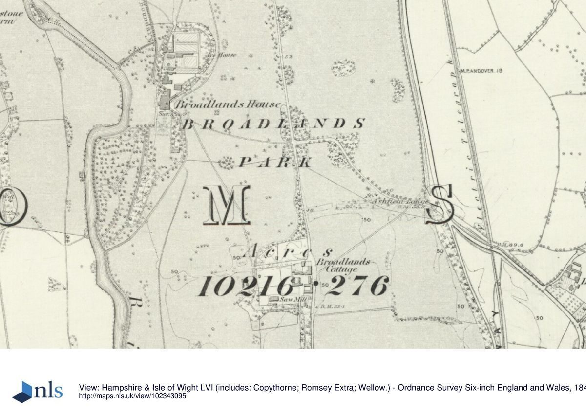
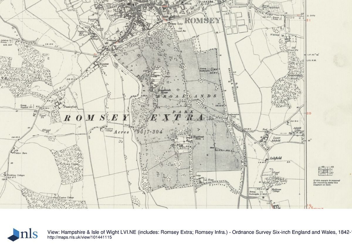
Broadlands is situated on the southern edge of Romsey, between the A31 and the A27 and some 6km north of Southampton. The registered site comprises 186ha, of which some 16ha are formal and walled gardens and pleasure grounds and c 170ha parkland and farmland, part of the latter being used as a showground. The site occupies the floor of the Test Valley, the ground rising up a slight bank east of the course of the river to form a level plateau.
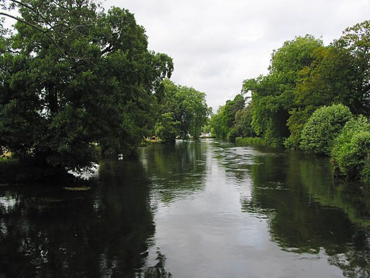
The northern and eastern boundaries are partly walled, from the adjacent Romsey bypass and town buildings to the north and from the A27 and open farmland to the east, the latter boundary enclosed by the Mile Wall, erected in the mid C19. An early C19 milestone (listed grade II) stands at the foot of the wall some 1.5km south of the junction of the A31 and A27. To the south, the parkland is enclosed by a minor lane (Spaniard's Lane) from flat arable farmland beyond, while to the west, the southern half of the park is bordered by the tree-fringed Test and the northern half by meadowland, beyond which the west side of the valley rises steeply to wooded ridges.
Entrances and Approaches
The main entrance lies at the northernmost point of the park, on the A31. A drive enters through gates beside the C20 Romsey Lodge and follows a gentle 'S' curve for c 800m through the park to the principal, east entrance front. A secondary drive to the house enters from the Southampton road on the eastern boundary (some 850m south-east of the house) at Sunflower Lodge (listed, as Ashfield Lodge, grade II*, with flanking walls and gates grade II), a two-storey, Tudor-style building of brick and a timber-framed upper floor with panels of pargetting, designed by W E Nesfield in 1868 (Riley 1993).
A further drive runs due south from the east side of Romsey Lodge to Lee Lodge and Lee House on Spaniard's Lane. This, known as the Burma Road, was the route of the former main Romsey to Southampton road (and the boundary of the park in the C18), which was diverted to its present line on the eastern boundary in the C19. The present main drive, and the section of the south-east drive west of the Burma Road, were laid out by Lancelot Brown, the south-east drive terminating at a pair of lodges on the Burma Road which were replaced by Nesfield's new lodge in 1868. Brown designed a third entrance on the northern boundary beside Middle Bridge over the Test (the entrance lost in the 1930s when the bypass was built) from which a drive (now a track) wound east then south, giving vistas of the house. The bridge was rebuilt in 1783 by the architect and engineer Robert Mylne (1734-1811), with an embellished south side, paid for by the second Lord Palmerston, which formed a feature in the view from the west front of the house.
Principal Building
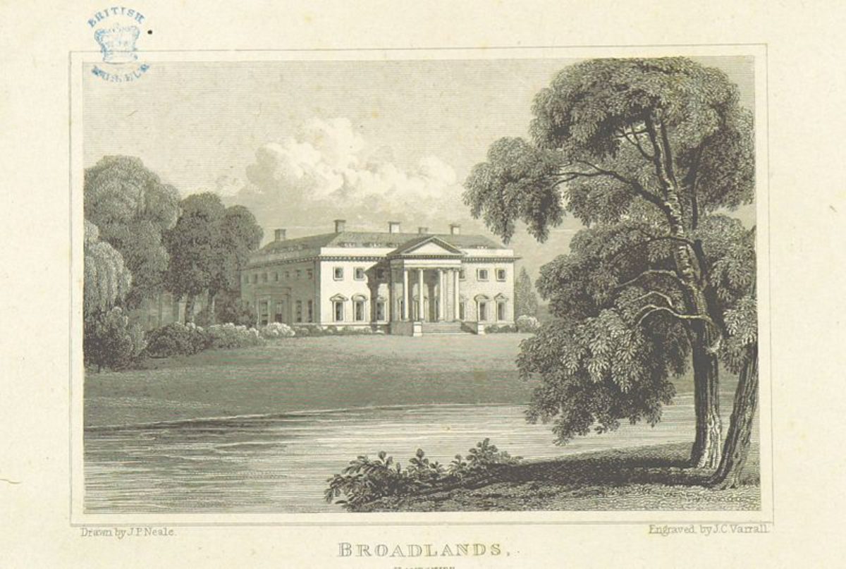
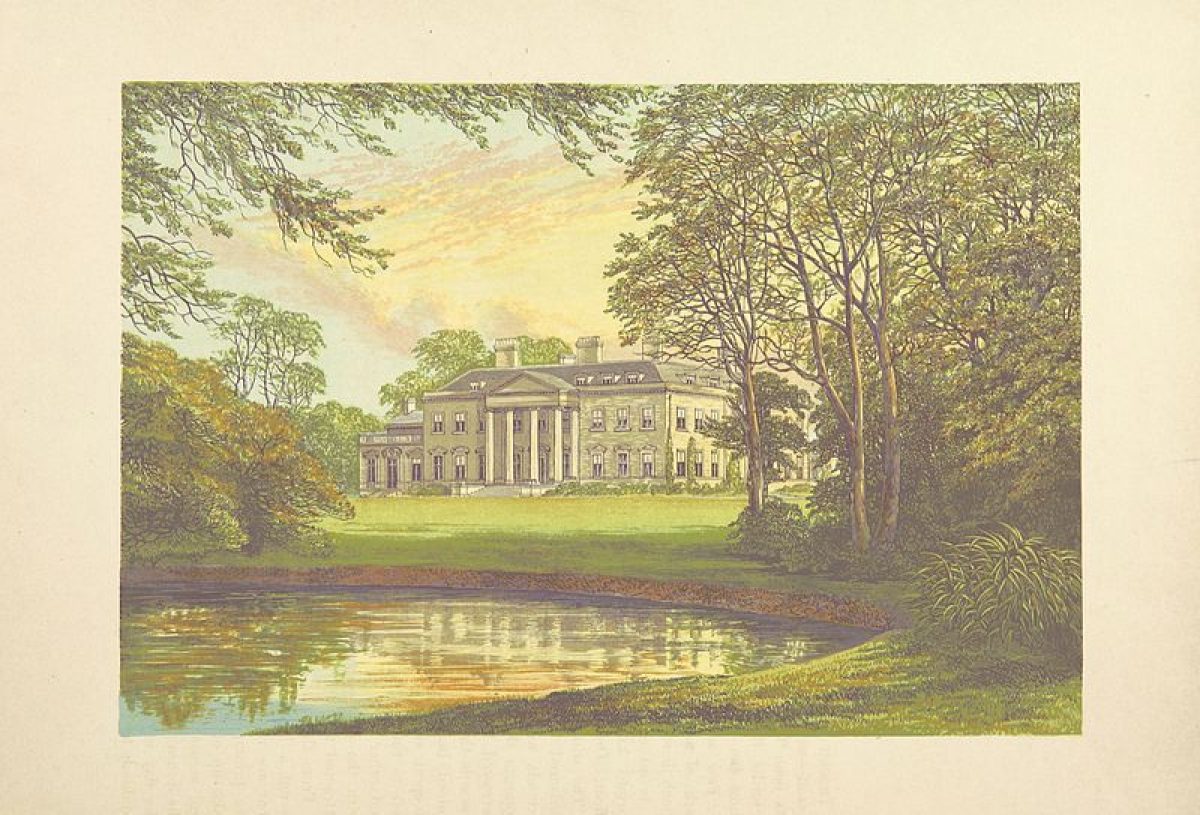
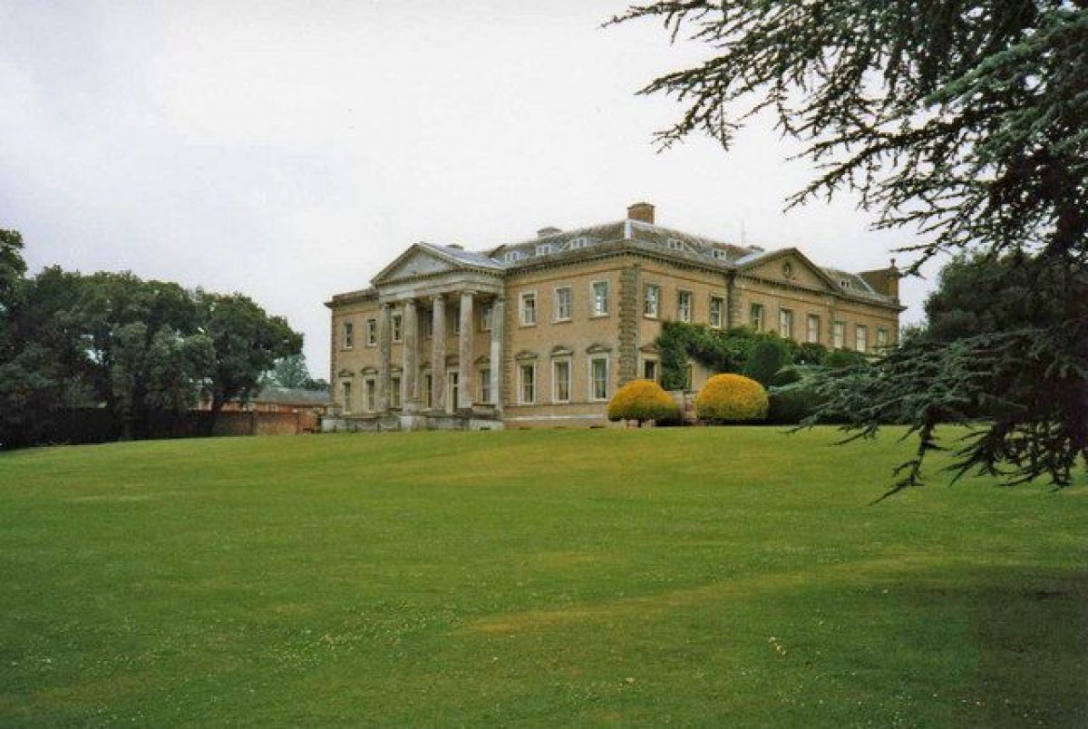
Broadlands (listed grade I) stands north of the centre of the park, on a slightly raised terrace above the Test with views westwards over lawns and the river to parkland and the wooded ridges around Sparsholt (with the remains of a gothic eyecatcher façade) beyond. The house is square in plan, of two storeys with an attic on the east and west sides and with a hipped, slate roof. Its walls are faced with yellow brick and the principal, east front consists of nine bays with a central three-bay portico with pediment, rendered to appear as stone. The main structure of the house was built in the C16 as an east-facing `U'.
Brown's external work from 1767 consisted of its refacing with the present brick and the remodelling of the west front with its Ionic portico and of the south front with its projecting pedimented bays. Henry Holland carried out internal alterations in 1788-9 and added the east front portico which enclosed the former, open entrance courtyard. Further alterations were made in 1859 to the east front when T L Donaldson raised the attic to a full extra storey and in 1899 when the walls which form the present entrance forecourt (listed grade II) were built by C H Nisbett.
To the immediate north-east of the house are the stables (listed grade II), a C17 and C19 red-brick block of two storeys with a hipped, tiled roof and with upper window openings of alternate circles and ovals. North-west of the stables is the Dairy House (listed grade II), an C18, part brick and part stuccoed building with gothic detailing which was probably converted by Brown from an older structure and was altered in the late 1780s by Henry Holland.
Gardens and Pleasure Grounds
The formal gardens and pleasure grounds lie to the west and south of the house, enclosed between the river along the west side and a brick ha-ha, with a footbridge to the park (ensemble listed grade II) on the eastern side.
The portico on the west front faces onto open lawn sloping gently down to the river. This is framed by trees, those at the northern end lining a stream which flows southwards, parallel to the Test (culverted beneath the lawn), into the pleasure grounds. Some 50m north-west of the house, beside the stream and buried beneath a grassed mound, is a late C17 engine house of vaulted chambers (rebuilt C19, listed grade II). Further north (c 25m north-west of the Dairy House), a late C19 brick and weatherboarded Pavilion (listed grade II), which formerly housed a generator, stands beside the stream.
The south front opens onto a gravelled walk and a rectangular terrace laid to open lawn and enclosed by a low stone wall and by topiary yew hedges. At the southern end is a circular pool. Beyond the terrace, further open lawns extend towards the ha-ha, those to the south open in character with a vista over the park and those to the east planted with tree groups including exotics. An C18 rectangular orangery (listed grade II*) of yellow brick stands some 120m south of the house, the Ionic portico at the western end designed by Brown in 1769 and the eastern four bays added by Holland in 1788. Immediately south of the south wall an early C19 Coade stone urn stands on a square pedestal (listed grade II).
A series of formal garden enclosures to the south of the house and extending south-west into the present pleasure grounds are shown, with the Orangery, on two mid C18 plans, one undated, the other of 1747 (Broadlands archive). Two surveys by Randall in 1785 and 1787 show these replaced by Brown's design of open lawns enclosed to the east on the line of the present ha-ha. By 1856 (early draft of OS 1st edition), a parterre had reappeared on the south front and in 1868-75, W E Nesfield was commissioned to lay out a formal terrace with a parterre and a pool which was simplified to its present appearance in 1954 (Riley 1993).
South and south-west of the formal garden, several paths lead into the pleasure grounds. These are planted informally with groups, loose belts, and individual trees of mixed ages and species, including exotics, interspersed with winding grassy glades. The stream, with occasional small waterfalls and an ornamental stone bridge, runs southwards through the centre of the grounds to the southern boundary where it flows into the Test. The redesigning of the gardens in a more informal style was begun in the mid C18 by the first Viscount Palmerston who reputedly employed William Kent (ibid).
Lord Palmerston wrote in 1736 that he was making `a fine gentle descent from the garden to the river, a little walk on each side, and a walk by the river half a mile long' (CL 1923). The plan of 1747 shows a wilderness at the southern edge of the present west lawn and trees planted along the stream. Randall's survey of 1785 shows Brown's pleasure grounds with a few tree clumps and the belt along the stream retained but with sweeping lawns of a largely open character. Further land east of the stream, which formed the limit of the garden in the mid C18, is shown enclosed as pleasure ground, although only the north-eastern length of the new boundary appears to follow the line of the present ha-ha. An extensive second phase of tree planting and the creation of shrubbery beds, which established the present character of the pleasure grounds, was begun in 1807. This appears on a plan at Broadlands dated 1825 and on the 1st edition OS map surveyed in 1866, this latter also showing the ha-ha wall on its present line.
Park
The park surrounds the house although only to a limited extent on the western side in the area known as Mainstone. To the north, north-east, and immediate east of the house as far as the Burma Road, the park is laid to permanent pasture and extensively planted with clumps, groups, and individual trees of mixed ages and species, including exotics, and with a perimeter belt along the northern boundary.
To the immediate south-east, towards Broadlands Farm in the area known as the South or New Park, the land is also laid to grass (re-established from arable in the 1990s) but is more open in character with largely clump planting. These areas of the park, with the eastern half of Mainstone, represent the extent of the land imparked and then laid out by Brown from 1767 to 1779, as shown on Randall's surveys of 1785 and 1787. The land was previously common fields, its only ornamental feature being a double avenue (described by Randall as of chestnut) which ran east from the house to the former main Southampton (now the Burma) Road (plan, 1747).
By 1811 (William Tubb survey), land south-west of Broadlands Farm to the present southern site boundary appears to have been added to the park and planted in Brown's style with clumps, a perimeter belt with rides, and a belt around the newly acquired farm itself. Tubb's survey also shows the beginnings of similar planting, including a perimeter belt, on land east of the Burma Road which was complete by the mid C19 (early draft of OS 1st edition, 1856). This land is now largely occupied by the showground and is laid to grass, its planting pattern surviving from the early to mid C19.
Considerable thinning and additional planting to Brown's clumps by the third Viscount was also carried out in the early to mid C19 and in the C20, Lord and Lady Mountbattten undertook the planting of commemorative trees. Following the loss of elms in the 1970s and severe storm damage in 1987 and 1990, the park has undergone comprehensive replanting to restore the structure of the Brown design as shown on the surveys of 1785 and 1787 and the additional areas laid out in the C19 in Brown's style.
Kitchen Garden
The kitchen garden lies some 70m north of the house and comprises a walled enclosure of c 125m x 100m built of red brick and dating from the C18 and C19 (walls listed grade II). The garden is subdivided by internal walls into a series of four compartments, the largest of which contains a range of glass (now, 1998, in poor condition), perimeter paths running beneath tunnel arbours of fruit trees, shrub beds, and lawn. The remaining compartments are laid to grass. The garden is enclosed from the park to the north and west by an ornamental belt of largely evergreen trees and shrubbery containing a gravelled walk which was planted as part of Brown's design and is shown on Randall's surveys. Within the tree belt, some 10m east of the east wall, is an early C19 icehouse (listed grade II) with a vaulted passage leading to a domed chamber.
Maps
- Survey of Broadlands estate, 1747 (Broadlands archive, University of Southampton)
- Survey of Broadlands estate, mid C18 (Broadlands archive, University of Southampton)
- Randall, Survey of Broadlands, 1767 (Broadlands archive, University of Southampton)
- Randall, Survey of Broadlands, 1785 (Broadlands archive, University of Southampton)
- Randall, Survey of Broadlands, 1787 (Broadlands archive, University of Southampton)
- William Tubb, Survey, 1811 (Broadlands archive, University of Southampton)
- Draft of OS 1st edition, c 1856 (Test Valley Archaeological Trust)
- OS 6" to 1 mile:
- 1st edition surveyed 1866
- 2nd edition published 1897
- 3rd edition published 1911
- 1938 edition
- OS 25" to 1 mile:
- 2nd edition revised 1896
- 3rd edition revised 1908
- 1941 edition
Archival items
- The Broadlands archive, with material dating from 1736, is held by the University of Southampton.
Description written: September 1998
Amended: May 2000
Register Inspector: VCH
Edited: January 2004, January 2022
- Visitor Access, Directions & Contacts
Access contact details
The house will open for tours in April 2022.
Guided tours are available on selected days. Group visits can also be arranged.
Visit the Broadlands Estates website for more information regarding tours.
Directions
The house is signposted from the A3090 south of Romsey.
Owners
Lord Brabourne and family
Broadlands, SO51 9ZD
- History
The following is from the Register of Parks and Gardens of Special Historic Interest. For the most up-to-date Register entry, please visit The National Heritage List for England (NHLE):
16th Century
Broadlands formed part of the abbey of Romsey in the C10. Surrendered to the Crown at the Dissolution in 1539, it was granted first to John Foster, a former steward to the abbey and then in 1544 to Sir Thomas Seymour, an uncle of Edward VI. He sold it in 1547 to Sir Francis Fleming whose granddaughter, Frances, married Edward St Barbe.
17th Century
It remained in the St Barbe family until the mid C17 and Sir John Barbe, who succeeded in 1661, made considerable improvements to the house and laid out an elaborate formal garden which was described by the writer Celia Fiennes on her visit c 1696 (Morris 1947).
18th Century
Sir John died in 1723 and his cousin and heir, Humphrey Sydenham, sold Broadlands in 1736 to Henry Temple, first Viscount Palmerston, the estate around the house and gardens consisting at this time of only the central part of the present park. Lord Palmerston began the replanning of the gardens down to the river along more informal lines in 1738-9, for which he is reported to have employed William Kent (1685-1748), before his death in 1757 and the succession of his grandson.
In 1767 the second Lord Palmerston commissioned Lancelot Brown (1716-83) to provide a comprehensive design for remodelling the house and surrounding grounds and for laying out and planting the parkland (Estate maps, 1785, 1787; Estate papers). Brown's son-in -law, the architect Henry Holland (1745-1806), further remodelled the house and two major garden buildings in 1788.
19th Century
The third Viscount Palmerston (1784-1865), who became Queen Victoria's Prime Minister in 1855, succeeded in 1802. He acquired further land to the west and south which allowed him to extend the park to its present boundaries and to continue with its improvement by replanting and adding to Brown's work and by new planting in Brown's style. Following Lord Palmerston's death, Broadlands passed first in 1865 to his younger step-son, William Cowper-Temple, Lord Mount Temple, for whom W E Nesfield (1835-88) designed a new formal garden with a pool on the south front.
20th Century
In 1917 Lord Palmerston's nephew, Evelyn Ashley, later created Lord Mount Temple of Lee (of the second creation), inherited. Broadlands then passed to his daughter, Edwina, who in 1922 married Lord Louis Mountbatten, later created Earl Mountbatten of Burma. The Romsey bypass was built along the northern edge of the park in the 1930s and after the Second World War, the Earl and Countess Mountbatten began planting commemorative trees in the park and simplified Nesfield's work in the garden. Broadlands passed to Lord Louis' grandson in 1979 and during the 1990s, following severe storm damage, the parkland planting was restored to Brown's design.
Broadlands remains (2022) in private hands.
- Associated People
- Features & Designations
Designations
The National Heritage List for England: Register of Parks and Gardens
- Reference: GD1063
- Grade: II*
Style
Informal
Features
- Mansion House (featured building)
- Earliest Date:
- Latest Date:
- Mansion House (featured building)
- Earliest Date:
- Latest Date:
- Key Information
Type
Estate
Purpose
Ornamental
Principal Building
Domestic / Residential
Survival
Extant
Hectares
250
Open to the public
Yes
Civil Parish
Romsey
- References
References
- {English Heritage Register of Parks and Gardens of Special Historic Interest}, (Swindon: English Heritage, 2008) [on CD-ROM] Historic England Register of Parks and Gardens of Special Historic Interest
- Pevsner, N. and D. Lloyd, {The Buildings of England: Hampshire and the Isle of Wight} (Harmondsworth: Penguin, 1967), p. 145 The Buildings of England: Hampshire and the Isle of Wight
- Page, W. {Victoria County History: Hampshire and the Isle of Wight, Volume 4 } (London: Constable, 1911), p. 452-4 Victoria County History: Hampshire and the Isle of Wight, Volume 4
- 53 (31 March 1923), pp 434-41; (7 April 1923), pp 466-73; 168 (11 December 1980), pp 2247-50; (18 December 1980), pp 2334-7 Country Life
- Riley, J., (1991) Broadlands Park, Hampshire, Landscape Report
- Riley, J., (1993) The Restoration of Broadlands Park