Introduction
Bradgate Park has developed from a medieval deer park with later 18th-century features, preserved as public parkland since 1928. Within the park are the ruins of Bradgate House, a brick mansion begun in the 1490s and abandoned in the 18th century, associated with which are the earthwork remains of its garden.
Terrain
The site lies on high ground on the south-east side of Charnwood Forest.www.historicengland.org.uk/listing/the-list
A medieval deer park, enclosed by 1241 and with later improvements, notably 18th-century stone walling and plantations, surviving as a public park. Within the park are the ruins of Bradgate House, a brick mansion begun in the 1490s and abandoned in the 18th century, associated with which are the earthwork remains of its garden.
DESCRIPTION
LOCATION, AREA, BOUNDARIES, LANDFORM, SETTING
Bradgate Park lies c 10km north of Leicester, on high ground on the south-east side of Charnwood Forest. The forest's remaining wastes were inclosed by Act of 1808, and the grid-like fields adjoining the park are of this date. It overlooks Cropston Reservoir, opened in 1870, which bounds the park to the east. The southern boundary runs along Bradgate Road, the northern a track leading west from Hallgates and the western follows field edges parallel to and east of Sharply Hill, the road leading north from Newtown Linford village. The area here registered is c 325ha.
ENTRANCES AND APPROACHES
There are numerous gates into the park, spaced every few hundred metres around its perimeter. Adjoining the entrances at the north-west (Hunt's Hill) and north-east (Hallgates) corners there are car parks. The third main entrance is at the south-west corner, from Newtown Linford. An engraving of 1794 (reproduced in Chandler 1993, 279) indicates that one of the main approaches to the mansion was at that date the track, then tree lined, which today passes between Holly Plantation and Thorn Spinney.
PRINCIPAL BUILDING
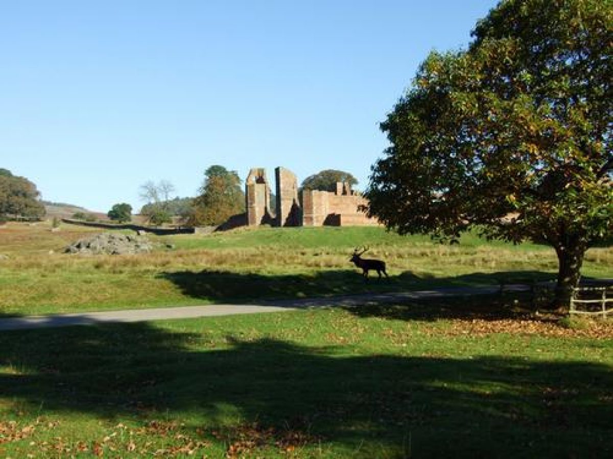
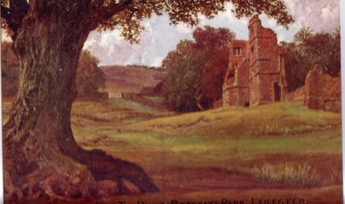
Standing in the south-eastern quarter of the park are the ruins of Bradgate House (listed grade II*), a brick mansion begun c 1490 by Thomas Grey and almost finished at the time of his death in 1501. It was of conventional U-plan, the long, east/west hall having projecting bays in the re-entrant angles, asymmetrical porches on the north and south sides, and a semicircular bay at the north, dias end. The south wing contained the private apartments, that to the west a kitchen and services. The only roofed portion of the House is the chapel, which leads off a solar east of the hall. This contains the monument to Henry Grey (d 1614), first Baron Grey of Groby, and his wife. Running east from the south-east corner of the mansion is a massive, diapered, stone and red-brick terrace wall (listed grade II*) of the early C16 which retains the 100m square level area to its north, known as the Tiltyard. The House was abandoned in 1720 on the death of the second Earl of Stamford in favour of the family's other seat at Enville.
Immediately outside the south-east corner of the Tiltyard are the ruins of a mill, fed from the triangular pond north of the House. When visited by Leland c 1540 he described the House as a lodge, and noted how a 'good and vigorous water supply has been channelled through the lodge by Master Brook (seemingly against the gradient) to turn a mill nearby' (Chandler 1993, 280).
GARDENS AND PLEASURE GROUNDS
On the east side of the House is a 100m square, brick-walled enclosure, probably laid out c 1500. The ground within is retained by the massive wall with external buttresses along its south side (listed grade II), its lower part of granite and slate rubble and its upper part, visible from within the complex, of brick. The interior of the enclosure is laid to grass, and has flat raised walks around the four sides. The enclosure is known as the Tiltyard, and was possibly built by the first Earl of Dorset, a celebrated jouster, as a practice ground. From at least the later C17 the enclosure was a walled lawn, divided by paths into quarters and with steps up onto the raised walks. These are shown on a drawing of the House made by Knyff c 1700 (reproduced in Stevenson and Squires 1994, 16) as are other walled compartments, probably kitchen and fruit gardens, to its east and along the north side of the whole complex. These are mostly represented today by wall footings. Knyff's view also shows how the leet down the east side of the Tiltyard had been made into a formal canal, crossed by a bridge. Before 1720 (map reproduced in Cantor and Squires 1997, 47) an avenue of Spanish chestnuts was planted running east from the House on the Cropston approach; no trace of these survives today.
Some 100m north of the Tiltyard is a triangular fishpond from which the House was supplied with water and the mill to its south-east powered.
PARK
The main car park lies at the south-west end of the valley, immediately outside the park. A broad tarmac path leads east from it, along the north side of the river, across a wide grass plain, past the south side of Bradgate House to the park's Visitor Centre, and then north-east up the edge of the park to the Hallgates car park.
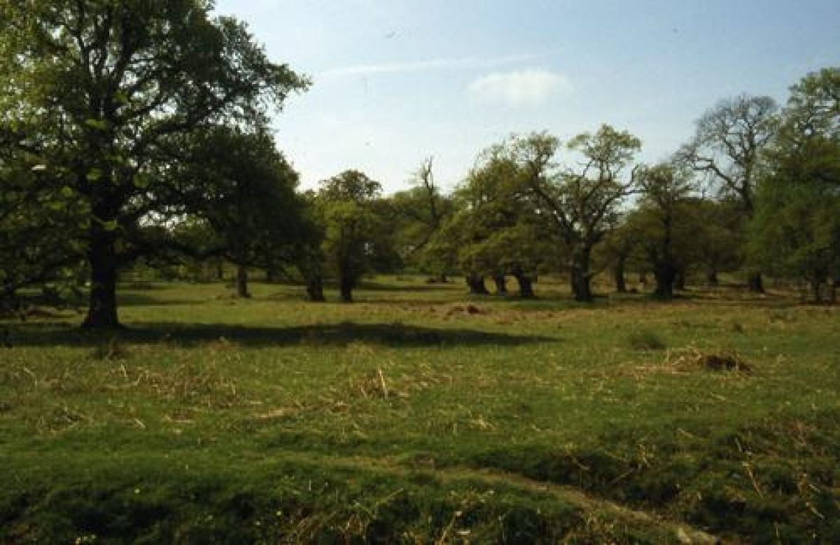
Bradgate Park is roughly square, and c 2km in diameter. It is almost wholly contained within a 2m tall stone wall, the north and west sides of the park being walled in the 1740s and much of the south and south-east in the 1790s. Its main topographical feature is the River Lyn, shallow and c 10m wide, which runs from east to west across its southern part and feeds Cropston Reservoir, which lies immediately east of the park. Near the south-west corner of the park the Lyn passes through a wooded valley with rocky outcrops called Little Matlock, and here the stream along the bottom of the valley was dammed c 1870 to create a chain of four ponds. The Wishing Stone, 400m north-east of the south-west entrance to the park, marks the site of a dam created c 1500 for a pond. From this water was carried in the leet which runs north-west to the triangular pond north of Bradgate House. Little Matlock, which is c 400m long, is one of the most densely wooded sections of the park, and both ancient oaks, some bearing the evidence of pollarding and others of coppicing, and coniferous and other specimen trees of C19 and later date, grow among the rocky outcrops of its sides.
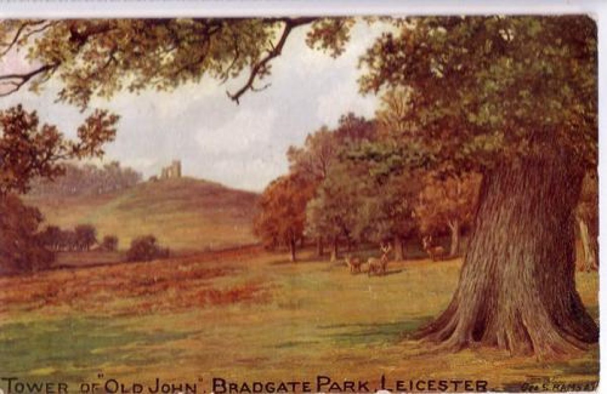
At the east end of Little Matlock the sometimes dense cover of ancient oaks continues along the land south of the Lyn, which is reserved as a deer sanctuary and not open to the public. To the north of the river, however, a broad, largely treeless, grass plain opens out at the end of Little Matlock, with the ruins of Bradgate House standing prominently 500m to the east. The plain is crossed by a 2m tall stone wall, like the park wall constructed c 1740, which passes along the north side of Little Matlock before running north-eastwards across the plain and to the north of the House. The wall divides the rising ground of the High Park, to the north, from the Low Park. Within the former, and one of the most distinctive features of the park, are six stone-walled woods and plantations, each roughly oval and most of them c 300m in diameter. These were created and walled c 1830 as cover for pheasants. Three other walled spinneys of that date lie in the Low Park. In the High Park the ground rises to the north, with the highest point being Old John, a rocky knoll close to the north-west corner of the park. On its top stands Old John Tower (listed grade II), a round, two-storey, crenellated gothick tower of 1784 to which a gothick arch was added some years later. It serves both as an eyecatcher and (although not currently accessible) as a viewing tower. Set in to the rock on the south side of the Tower are the surviving portions of stables built in the mid C19 for the seventh earl of Stamford's race horses, which ran on a course laid out in the park. Some 200m to the south-west on a lower knoll is the Leicester Yeomanry War Memorial (listed grade II) of 1920, a 10m high, granite chip, concrete obelisk on a stepped plinth. It incorporates a cross and wreaths and has plaques recording the fallen of both World Wars.
On the south side of the path through the park, midway between the east end of Little Matlock and Bradgate House, is the Pheasantry, a square enclosure surrounded by a 2.5m tall stone wall, perhaps C19. An enclosure, perhaps as now used for deer management, was already present here c 1700; in the C19 it was used as a pheasantry. A bridge south-west of Bradgate House marks the old approach to it from Leicester. The Visitor Centre, 500m east-north-east of the House, is an L-plan brick and stone complex, built in the mid C19 as a deer barn and agricultural buildings. To its south-west is a level area of improved grassland, improved in the early C19 as a water meadow to supplement the park's grazing. Two hundred metres north of the Visitor Centre is the Warden's Lodge, built c 1870 to replace a house lost beneath the new Cropston Reservoir. Also covered by the water is the site of the park's rabbit warren, and possibly at least a part of the area occupied by the medieval settlement of Bradgate. That had forty-one tax payers in 1377 and twenty-nine c 1400. The village was apparently removed c 1490 when the House and enlarged park were created; its inhabitants may have been rehoused in Newton Linford, immediately outside the southern boundary of the park. Ridge and furrow in the north-east corner of the park, east of Coppice Plantation, is believed to be part of Bradgate's open field land, inclosed c 1500. Similarly, ridge and furrow in the south-west corner of the park represents field land belonging to Newton Linford taken into the park about the same time.
A park was enclosed at Bradgate before 1241. It was probably oval and c 2km in diameter from east to west, its longer axis. Parts of its western and north-western boundary bank are traceable c 500m west and north-west of Bradgate House, running south from Anstey Tops (where oaks of c 1500 stand on the bank) past the east end of Little Matlock, the east side of Elder Plantation and then through Dale Spinney. Also extant is a length of its north-eastern boundary 1km north-east of the House to the south-east of Coppice Plantation. The site of this park's lodge is marked by a moated site on the north side of the main path c 250m west of Bradgate House. About 1500 the park was more than doubled in size and it was probably then that the park's present north, south and west boundaries were established, while the east boundary ran up to a kilometre east of the later one, encompassing inter alia the area now occupied by Cropston Reservoir.
The public had been admitted to the park on a regular basis since the early C19. In 1928 it was given to Leicester City by Charles Bennion for recreational purposes, and in 1970 was designated a country park. As far as is known the park has always contained deer; since the later C18 there have usually been c 300 head, about half red and the remainder fallow.
REFERENCES Used by English Heritage
Transactions of the Leicestershire Arch Hist Soc 46, (1970-1), pp 19-20 Bradgate Park, guidebook, (1974)
J Stevenson, The Greys of Bradgate (1974)
N Pevsner, E Williamson and G K Brandwood, The Buildings of England: Leicestershire and Rutland (1984), pp 108-9
A E Squires and W Humphrey, The Medieval Parks of Charnwood Forest (1987)
J Chandler (editor), John Lelands Itinerary: Travels in Tudor England (1993), pp 279-80
Bradgate Park, guidebook, (1994)
L Cantor and A Squires, The Historic Parks and Gardens of Leicestershire and Rutland (1997)
Maps
OS 6" to 1 mile: Leicestershire sheet 24 SE, 1st edition published 1888; 2nd edition 1904; 1930 edition
OS 6" to 1 mile: Leicestershire sheet 25 SW, 1st edition published 1888; 2nd edition 1904; 1950 edition
OS 25" to 1 mile: Leicestershire sheet 24.16, 1st edition published 1884; 2nd edition 1903
Description written: June 1998
Edited: July 1999
- Visitor Access, Directions & Contacts
Telephone
07740 406661Website
https://www.bradgatepark.orgAccess contact details
Open daily. For details see: http://www.goleicestershire.com/outdoors/thedms.aspx?dms=3&venue=2500180
- History
The following is from the Register of Parks and Gardens of Special Historic Interest. For the most up-to-date Register entry, please visit the The National Heritage List for England (NHLE):
www.historicengland.org.uk/listing/the-list
HISTORIC DEVELOPMENT
At the time of the Conquest Bradgate was part of the manor of Groby, within the waste of Charnwood Forest. The manor formed part of the possessions of the heiress Elizabeth Ferrers, who in 1427 married Edward, younger son of Lord Reginald Grey, third Baron Grey of Ruthin. Their son, Sir John Grey, married the wealthy Elizabeth Woodville, and they had two sons, Thomas and Richard. After the second Battle of St Albans in 1461 in which Sir John was killed, the Grey estates were confiscated. Elizabeth then secretly married Edward IV and had a son Edward, who after the death of Edward IV was almost certainly murdered by Richard III along with his brother Richard, 'The Princes in the Tower'. After the death of Richard III at Bosworth Field in 1485 the family fortunes revived, and Thomas Grey was created Marquis of Dorset. From about 1490 he began to create a major new manorial base at Bradgate in place of Groby, enlarging the park and beginning the construction of a large brick mansion within it. He died in 1501 before the house was complete, and it was his son, Thomas, second Marquis, who completed the work and was the first of the family to live there. He died in 1530, and was succeeded by his son Henry, who was created Duke of Suffolk in 1554 but beheaded later in the same year. The same fate also befell his daughter, Lady Jane Grey, who had been born at Bradwell in 1537 and brought up there before her marriage in 1553 to Lord Guildford Dudley and subsequent proclamation as Queen on the death of Edward VI. Bradgate was confiscated, but restored to the family in 1603 when Henry Grey (died 1614), the nephew of the third Marquis, was created Baron Grey of Groby. He made Bradgate his seat. His heir was his grandson Henry (died 1673), who in 1628 was created Earl of Stamford as acknowledgement of his wife's position as co-heir of William Cecil, second Earl of Exeter. His son Thomas, who predeceased him, was among the regicides. Thomas, the second Earl of Stamford, was the first Earl's grandson; during his time at Bradgate, in 1696, it was visited by William III. On his death in 1720 his estates and title passed to his cousin Henry Grey of Enville (Staffordshire - see description of this site elsewhere in the Register); Bradgate appears, effectively, to have been abandoned, and by the middle of the century was becoming ruinous. The park remained in the family until 1928 when it was bought by Charles Bennion, a local industrialist, who presented it to 'the people of Leicester for their quiet enjoyment'. Its administration was placed in the hands of the Bradgate Park Trust, which remains (1998) the managing body.
Period
- 20th Century (1901 to 2000)
- Early 20th Century (1901 to 1932)
- Features & Designations
Designations
The National Heritage List for England: Register of Parks and Gardens
- Reference: GD1956
- Grade: II
Features
- Folly
- Description: Old John Tower folly.
- Earliest Date:
- Latest Date:
- Ruin
- Description: The ruins of Bradgate House, the earliest parts of which date back to the 15th century.
- Mansion House (featured building)
- Description: Bradgate House, a brick mansion begun in the 1490s and abandoned in the 18th century.
- Earliest Date:
- Deer Park
- Gardens
- Key Information
Type
Park
Purpose
Recreational/sport
Principal Building
Parks, Gardens And Urban Spaces
Period
20th Century (1901 to 2000)
Survival
Part: standing remains
Hectares
325
Open to the public
Yes
Civil Parish
Newtown Linford
- References
References
- {English Heritage Register of Parks and Gardens of Special Historic Interest}, (Swindon: English Heritage, 2008) [on CD-ROM] Historic England Register of Parks and Gardens of Special Historic Interest
- Pevsner, N., {The Buildings of England: Leicestershire and Rutland} (Harmondsworth; Penguin, 1984). pp. 108-9 The Buildings of England: Leicestershire and Rutland