Introduction
Rauceby Hospital was a mental hospital designed by George T Hine, with grounds and gardens laid out by William Goldring in 1900. The layout featured airing courts, a chapel, a conservatory and a shelter. The hospital closed in the late-1990s and the site is currently (2008) being redeveloped for housing.
Terrain
The land is largely level, with a slight slope from the main building down to the north.www.historicengland.org.uk/listing/the-list
The grounds of a medium-sized, echelon-style psychiatric hospital, opened in 1902, laid out to a plan of 1900 by William Goldring.
DESCRIPTION
LOCATION, AREA, BOUNDARIES, LANDFORM, SETTING
Rauceby Hospital stands towards the centre of Lincolnshire, 3km west of Sleaford, between the villages of South Rauceby to the north-west, and Quarrington to the east. The c 50ha site lies in a rural setting, and is bounded to the north by the railway linking Grantham, Sleaford, and Boston (formerly GNR), and to the east by agricultural land, from which it is divided by an iron park fence. To the west and south the site is bounded by a lane, Willoughby Road, linking South Rauceby with Silk Willoughby to the south-east. Much of the boundary is marked by belts of trees and woodland. The land is largely level, with a slight slope from the main building down to the north. Rauceby Station (outside the area here registered) lies 400m north-west of the hospital building, at the north-west corner of the site, it having formerly provided a principal means of transport to the hospital for visitors and goods.
ENTRANCES AND APPROACHES
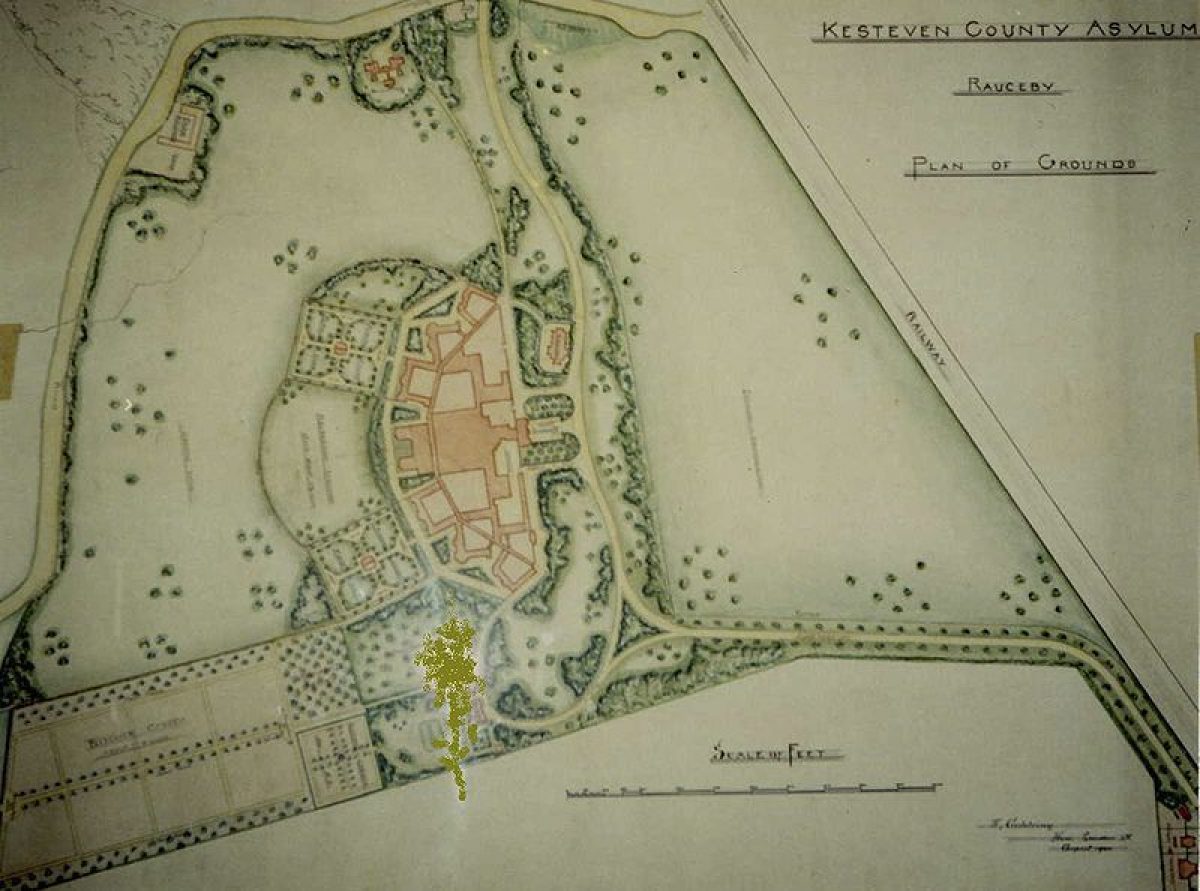
The north approach to the hospital enters the park at the north-east corner of the site, off the A153 Grantham to Sleaford road, 600m north-east of the main, north entrance to the hospital building, giving access directly from Sleaford. The entrance to the site is marked on the south side by an early C20, two-storey brick lodge in Tudor style, with several staff houses in similar style standing adjacent to the east. The entrance is flanked by a dwarf brick wall to the north and iron railings to the south. From here the north drive extends south-west for 150m, parallel to, and to the south of the nearby railway line, flanked by an avenue of mature trees. Some 450m north-east of the hospital building the drive turns south, running along the east side of the parkland, lined by an avenue of mainly lime trees and hollies. Two spurs lead west off the drive to give access to staff housing and Orchard House Hospital which are set in the north park. The drive turns west 175m north-east of the hospital, bounded to the north by a belt of mature trees and to the south by a lawn, before entering the forecourt on the north front of the hospital building and approaching the main, central entrance. The forecourt is bounded to the west and east by mature trees and shrubs and to the north by the belt of woodland including mature holm oaks and hollies. To the east of the forecourt a spur south, off the north drive, gives access to the service yards on the east side of the hospital.
Some 175m east of the hospital, a spur curves south from the north drive, flanked by mature trees and shrubs, leading to the north, entrance front of the former Medical Superintendent's residence (now, 2000, a medical training facility). From here the spur continues around in a loop to the north-west, through mature mixed woodland. It extends west along the east side of the north front of the hospital building to join the spur off the north drive east of the forecourt. This provides direct access from the Medical Superintendent's residence to the hospital.
A second, west drive enters 375m west of the hospital towards the centre of the west boundary, off Willoughby Road, giving access directly from the village of South Rauceby and Rauceby station. The entrance is marked on the south side by an early C20 two-storey brick lodge in Tudor style, and is flanked by iron gates and railings set upon dwarf brick walls. From here the drive, lined by an avenue of trees, extends east through the parkland to the forecourt on the north side of the hospital, passing close to the north side of the brick chapel (c 1900) which stands above the drive.
The drive system was laid out 1901?2, to Goldring's plan, and the lodges were built at the same time to designs by G T Hine (Minute Book, 1901-2).
PRINCIPAL BUILDINGS
The two-storey hospital building (G T Hine 1899-1902) stands at the centre of the site, built of brick as a series of pavilions set in echelon form. The Tudor-style administration block stands at the centre of the north front, with a water tower close by to the south-east. The administration block terminates the north end of a central, spinal service block, including kitchens and a recreation hall. This service block is in turn flanked to the east by the three former male accommodation pavilions, linked by a long corridor, and to the west by the three former female accommodation pavilions, linked in similar fashion. On the north front, to the west and east of the administration block, lie service yards and former drying grounds, separated from the ornamental grounds to the north by a brick wall. The north side overlooks the drives and their wooded backdrop to the north. The south, west, and east sides of the building overlook the areas of former airing courts, parkland, and orchard.
The Home Farm and isolation hospital were built on the west boundary at the same time as the main hospital building. Further buildings were added to the periphery of the main hospital building and in the north park during the C20.
GARDENS AND PLEASURE GROUNDS
The gardens consist largely of a series of former airing courts for the patients' recreation. Most of these lie to the west, south, and east of the pavilion wards, which open directly onto them. To the south of the wards lie the two main, rectangular airing courts, these being laid to lawn and flanked by mature trees and flowering shrubs. Each contains a formal path system in cruciform pattern, surrounded by a perimeter path, at the centre of which stands an octagonal wood and iron shelter (supplied by the firm Boulton and Paul, 1902/03). Each airing court retains lengths of iron boundary fencing along the west and east sides, and contains a small enclosed lawn, iron-fenced and gated, close to the main building. The now lost sections of boundary fence were taken down in 1930 when a policy of giving patients more freedom of access to the grounds was being adopted (Stratten 1992). Spurs off these two airing courts extend to north-west and north-east respectively, to allow direct access from the furthest west and east ward pavilions respectively. The north-east court contains an early C20, brick outdoor privy for male patients. The airing courts overlook the parkland and orchard to the south.
Two further airing courts lie enclosed by elements of the hospital building. They are largely laid to lawn with perimeter paths, with that to the west containing a pond. In each a rectangular shelter stands against the north wall.
To the south of the central service block, separating the two main airing courts, lies an area of lawns surrounded by mature trees. To the south of these lies a further area of lawn in which stands a mature walnut tree. At the centre of the south side of the service block stands a large wood and iron conservatory (early C20).
The airing courts were laid out according to the recommendations of the Commissioners in Lunacy's Suggestions and Instructions (1856), that they 'should be of ample extent so as to afford proper means for healthful exercise [for the patients]. They should all be planted and cultivated, and any trees existing within them should be preserved for shade'. This was amplified in H C Burdett's influential text Hospitals and Asylums of the World (1891): 'The courts should be laid out as gardens, and orchards, and lawns. The walks should be twelve or fifteen feet wide, and laid down to asphalt or concrete. All the courts should have sun-shades and kiosks'. Goldring's plan (1900) shows the two main, external airing courts, each laid to lawn divided by two central paths in a cruciform pattern and with a perimeter path and central shelter, a scheme which was executed. His suggested planting around the edges of the quarters of the lawns does not seem to have been carried out however; he also suggested a 2.25 acre (c 1ha) recreation ground between them, which does not appear to have been laid out in this form, the area instead being planted with trees enclosing lawns. Around the rest of the main building he suggested a ring of informal planting which was executed.
The former Medical Superintendent's residence (c 1900?02), built of two storeys in brick and set within its own grounds, stands 225m south-east of the hospital building. The garden door on the south front opens onto a grass terrace, from which two flights of stone steps, one at each end, lead south down a grass slope to a large square lawn, bounded to the west by a yew hedge (overgrown, 2000), and to the south by mature trees including several large holm oaks. East of the house lies a square sunken garden enclosed by mature trees and shrubs and laid out with stone kerbs and steps. To the south of the Superintendent's garden lies an area of orchard, formerly the kitchen garden for the house.
The Superintendent's garden was laid out much as Goldring envisaged, as indicated on his plan of 1900 for the asylum grounds.
PARK
The park is divided into northern and southern sections by the west drive, the hospital itself, and the southern loop of the north drive. The southern half of the park is largely open and laid to pasture, with an area of former playing fields to the south of the west airing court, adjoining Willoughby Road to the south and west. A rectangular orchard separates the east airing court from the Superintendent's residence and garden. At the south-west corner of the south park, 300m from the hospital building, stand the Home Farm buildings and yard (c 1900, now, 2000, derelict) and adjacent to the south of these, four C20 staff houses. North of the farm stands the former isolation hospital, set in its own grounds, overlooking Willoughby Road to the west. A C20 nurses' home and other buildings stand close to the north drive, west of the main hospital building.
The northern half of the park is bounded to the west by a belt of woodland and to the north by a belt of trees separating it from the railway beyond. The open west half is laid to pasture. The east half contains Orchard House Hospital (a mid C20, single-storey administrative unit), and staff housing, set in pasture and lawns.
The agricultural land and farm formed an important element of the therapeutic regime for the male patients, as in all pauper asylums, until the mid 1960s, when the farm was shut down.
Goldring's plan showed the north and south park planted with scattered clumps of trees and singles, although these, if ever planted, have now (2000) largely gone.
KITCHEN GARDEN
No kitchen garden appears to survive. Formerly (OS 1905) a c 0.8ha nursery lay at the north-east corner of the north park; this may have been the site of the tree and shrub nursery which was set up in 1902-3 (9th Annual Report, 1905) in advance of the grounds requiring planting and which was subsequently replenished. Goldring's plan (1900) showed a very large kitchen garden to be sited adjacent to, and south of the Medical Superintendent's own kitchen garden, but it is uncertain whether this was ever laid out. There was certainly a kitchen garden of some sort, as the Annual Reports regularly mention the provision of vegetables from the garden (eg Annual Reports 1905, 1907), which until the mid C20 was maintained by the male patients as part of the therapeutic regime.
OTHER LAND
The asylum cemetery lies 300m south-west of the hospital on level ground to the south of Willoughby Road. The site was bought in 1905 and laid out in 1906 (Committee of Visitors Minute Book), it first being used for interment on 11 October of that year. The rectangular cemetery, divided from the road to the north by a wall and entered via iron entrance gates, is laid to lawn and enclosed by mature trees. A further, triangular cemetery lies close by to the north-west, to the east of Brockwater Spinney.
REFERENCES
Commissioners in Lunacy, Suggestions and Instructions (1856, revised 1887, 1898)
H C Burdett, Hospitals and Asylums of the World (1891)
Royal Institute of British Architects, Journal, (23 February 1901), p 169, plate XI
Sleaford Gazette, October 1901
N Pevsner et al, The Buildings of England: Lincolnshire (2nd edition 1989), p 667
G M Stratten, Rauceby Reflections The Story of a Mental Hospital 1902-1992 (1992)
Maps
W Goldring, Kesteven County Asylum, Rauceby Plan of Grounds, 1900 (Orchard Hospital, Rauceby)
OS 6" to 1 mile: 2nd edition published 1905
OS 25" to 1 mile: 2nd edition surveyed 1903, published 1905
Archival items
Some archival items remain, including the Visiting Committee Minute Books and Annual Reports, at the Lincolnshire Archives, Lincoln.
Hospital file 102553 (National Monuments Record, Swindon)
Description written: May 2000
Edited: June 2002
- Visitor Access, Directions & Contacts
Owners
South Lincs. Comm. & Mental Health Services
- History
The following is from the Register of Parks and Gardens of Special Historic Interest. For the most up-to-date Register entry, please visit the The National Heritage List for England (NHLE):
www.historicengland.org.uk/listing/the-list
HISTORIC DEVELOPMENT
The Kesteven County Lunatic Asylum, situated at South Rauceby, was designed in 1898 by the asylum designer George T Hine, to supplement the provision offered by the Lincolnshire county asylum at Bracebridge Heath (opened 1852). The Kesteven asylum was intended to serve the pauper agricultural population of rural Lincolnshire. A 112 acre (roughly 46 hectare) agricultural estate, Quarrington Glebe, was acquired in the late 1890s at £50 per acre (£120 per ha). Hine produced a design to accommodate around 420 patients, the ward pavilions being laid out in echelon arrangement to form a broad arrow plan. The echelon style, developed in the 1870s and 1880s, had by this date become the common pattern for asylum buildings. The wards were intended each to be occupied by a different medical class of patient, including sick and infirm, recent and acute, and epileptic. The airing courts were arranged adjacent to the wards as in earlier 19th-century asylum designs, and the parkland, including a farm, enclosed the building and courts. The asylum opened to patients on 20 June 1902, the building works having cost £156,785 (8th Annual Report, 1904).
The Minute Books of the Visiting Committee of Kesteven County Asylum (1894-1925) provide information on the period during which the building was erected and the grounds were laid out, the latter starting in September 1899 and continuing until 1906. The Minutes detail the initial engagement in 1899 of Mr R Lloyd, Gardener at the Surrey County Asylum at Brookwood, to advise on the planting and layout of the grounds and roads. Lloyd was unable to carry out the commission due to ill health and following his resignation, William Goldring was engaged in July 1900 at 4 guineas per day and produced a layout plan in August 1900. Over the following six years the plan was executed largely to Goldring's design and under his supervision, incorporating some modifications suggested by the Committee.
By 1905 (9th Annual Report, 1905) the grounds layout had cost £1,072, with £624 spent on iron fencing and £125 upon a conservatory attached to the south front of the main building. Much of the landscaping, particularly the planting, was carried out by the male patients as a part of their therapy, as had been the case in many other asylums.
Several peripheral buildings were added during the 20th century, including an admission hospital in the north park and adjacent staff housing. The RAF occupied the hospital during the Second World War. The asylum, renamed Kesteven Mental Hospital in 1922, and Rauceby Hospital in 1948 (Stratten 1992), closed in the late 1990s and is at present (2000) awaiting redevelopment.
Period
- 20th Century (1901 to 2000)
- Early 20th Century (1901 to 1932)
- Associated People
- Features & Designations
Designations
The National Heritage List for England: Register of Parks and Gardens
- Reference: GD4376
- Grade: II
Features
- Hospital (featured building)
- Description: The hospital was designed by the asylum designer George T Hine. It opened to patients on 20 June 1902, the building works having cost #156,785.
- Earliest Date:
- Latest Date:
- Tree Belt
- Description: Much of the boundary is marked by belts of trees.
- Key Information
Type
Garden
Principal Building
Health And Welfare
Period
20th Century (1901 to 2000)
Survival
Part: standing remains
Hectares
50
Open to the public
Yes
Civil Parish
South Rauceby
- References
References
- {English Heritage Register of Parks and Gardens of Special Historic Interest}, (Swindon: English Heritage, 2008) [on CD-ROM] Historic England Register of Parks and Gardens of Special Historic Interest
- Pevsner, N. and J. Harris, {The Buildings of England: Lincolnshire} (London: Penguin, 2nd edition 1989), p. 667 The Buildings of England: Lincolnshire