Introduction
Belgravia Square is an early-19th century private square covering about 2 hectares. The development was begun in 1825 by Thomas Cubitt, with George Basevi as architect, and was completed about 1827. The layout and planting became more ornate during the late-19th century.
Terrain
The mainly level site has a raised area in the middle which survives from around 1894.www.historicengland.org.uk/listing/the-list
Four early 19th century garden squares established as part of the town-planning scheme for Belgravia by Thomas Cubitt and his associates.
DESCRIPTION
LOCATION, AREA, BOUNDARIES, LANDFORM, SETTING
Belgravia lies in central London, to the south of Hyde Park (qv), west and south of Green Park (qv), east of Kensington, and north of the River Thames. A single road connects all the squares registered here and runs south-east from the west side of Wilton Crescent to Belgrave Square, through Eaton Square as Belgrave Place, and then through Chester Square as Eccleston Street. This main axis is orientated north-west to south-east. At Ebury Street, c 60m south-east of Chester Square, the axis shifts slightly to the east and then crosses Buckingham Palace Road before entering Pimlico and running along the north-east sides of Eccleston Square (qv) and then Warwick Square (qv) as Belgrave Road.
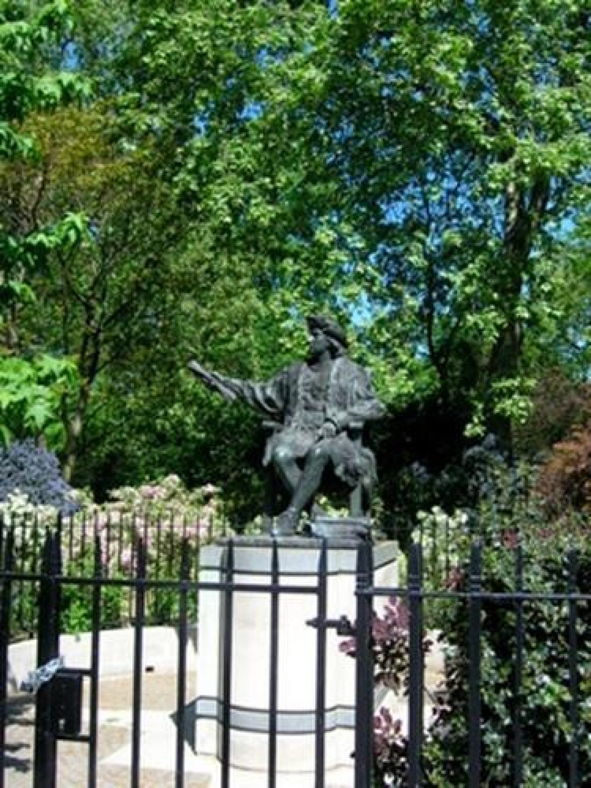
Belgrave Square is located in Belgravia, to the west of Buckingham Palace (qv), to the south of Hyde Park, and c 600m to the north-west of Victoria Station. It is bounded on all four sides by the roads and houses of Belgrave Square. The railings around the 2ha site were removed during the Second World War and, in the 1970s, new railings of a more modern design were installed. Memorial sculptures are positioned in the gardens on the east corner (Simon Bolivar, erected 1974), the south corner (Christopher Columbus, erected 1993), the north corner (San Martin, liberator of Argentina, erected 1994), and the west corner (Prince Henry the Navigator, erected 2002). These necessitated alterations to the railings and the boundary plantings. The mainly level site has a raised area in the middle which survives from c 1894. There are four entrances to the garden from Belgrave Square, one on each side of the site, all leading to the perimeter gravel path. The terraced houses around the square are of five or six storeys, including attic and basement. The north and east sides have a six-column centre, the centre on the south-side has eight columns, and that on the west centre has four. Houses Nos 1-36 and 38-48 are listed grade I, Nos 37 and 49 are listed grade II*.
Chester Square is located in Belgravia, c 75m to the south-east of Eaton Square, c 400m to the south-east of Belgrave Square, and c 300m to the west of Victoria Station. The two rectangular gardens of the square are laid out on level ground and are enclosed by railings which were reinstated to the original design in the 1970s. The c 0.4ha gardens are bounded to the north and south by Chester Square. Eccleston Street runs through the centre. There are entrances through simple gates in the north and south sides of the gardens, four to the west garden and two to the east garden, as pairs on the opposite sides. There are terraces of stuccoed houses by Thomas Cubitt (1835, mostly listed grade II) to the north, south, and at the east end. There are no houses along Eccleston Street which separates the gardens. The west end of the square is terminated by St Michael's church (Thomas Cundy 1844, listed grade II).
Eaton Square is located in Belgravia, c 600m to the west of Buckingham Palace, c 700m north of Victoria Station, and c 250m south-east of Belgrave Square. The six rectangular gardens that form the square fill a 6ha rectangular site, which runs north-east/south-west for c 473m, enclosed by the roads of Eaton Square, bisected north-east/south-west by King's Road, and further crossed north-west/south-east by Eccleston Street and Lyall Street. The streets effectively divide the area into six related rectangles, the middle pair being the largest. All the gardens are on level ground and are enclosed by railings which were reinstated in the 1970s. The individual gardens are all entered from the Eaton Square side; the larger two gardens have two entrances, the other four have one centrally placed entrance, positioned as recorded on the 2nd edition OS map of 1894. The houses of Eaton Square were developed by Cubitt and Seth-Smith who erected three blocks of houses on each side. The middle ones have the most pronounced motifs. Those on the north-west side of Eaton Square (listed grade II*) were built by Cubitt between 1826 and the end of the 1840s. The houses on the south-east side (the majority of which are also listed grade II*) were built by Seth-Smith c 1825-30. The stucco houses, most converted into flats in the 1950s, are of four storeys with basement and attic, and most have projecting Doric porches. All are an intergral part of Eaton Square's planned layout for which the gardens were made. The row of stuccoed houses to the south (listed grade II) dates to the mid C19; all the houses have five storeys and a basement, with a balustraded first-floor balcony and projecting Doric porches. The C19 St Peter's church (listed grade II*) is situated in the north-east corner of Eaton Square.
Wilton Crescent is situated in Belgravia, c 800m west of Buckingham Palace, c 100m north-west of Belgrave Square, and c 900m north-west of Victoria Station. The c 0.2ha crescent-shaped garden is bounded by C20 railings and has entrances on the east side of the straight south-east side and on the central part of the curve. The houses on Wilton Crescent (mostly listed grade II) surrounding the gardens were built in 1827 by Seth-Smith and Cubitt. Those on the curving north-west to north side are divided into two terraces by Wilton Place which runs off the centre of the curving side of the Crescent. These terraces were refaced in stone in the 1900s by Balfour and Turner. The houses along the south-east side are stuccoed.
GARDENS AND PLEASURE GROUNDS
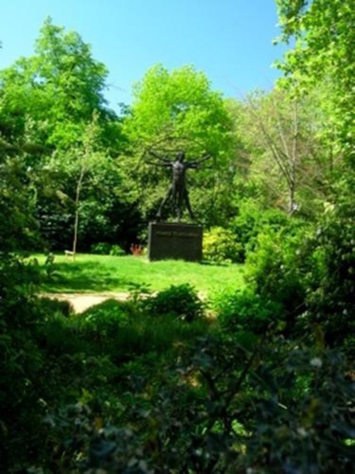
The garden of Belgrave Square is screened from the road by evergreen shrubberies much as shown on the OS maps of 1864 and 1897, although the C19 grass verges have gone. The paths have recently (late C20) been renovated and restored to their original layout. From the gravel perimeter path a series of serpentine paths leads to a circular inner path. The ground between the outer and inner paths is laid to grass and shrubberies similar to the C19 design. The entrance to the inner circle of the garden is controlled by a C20 chain-link fence and oak entrance gates. This innermost area of the inner circle is raised above the rest of the garden and supported first a single tree, then, in 1867, a seat, which is not shown on the next available map of 1894. A hard tennis court, screened from the rest of the garden by an evergreen hedge, was made on the south-west side of the mound in 1928, formalising the late C19 tradition of lawn tennis in the garden. A C20 children's playground is situated to the north-east of the mound. The circular inner gravel path has four C19 Classical-style shelters situated at regular intervals alongside the path. The shelters, painted with four Doric columns, and a plain entablature with pediment (2002), had by 1894 replaced seats shown on the 1867 plan. A late C20 wooden pergola with trellis sides has been erected on the south side of the inner circle and there is an enclosed garden in the south-west corner of the square. A number of mature plane trees survive on the lawns and in the shrub beds. Within the garden there is a statue of the Homage to Vitruvian Man by Plazzotta and a bust of George Basevi, architect of Belgrave Square. There is also a statue of Robert Grosvenor, first Marquess of Westminster, in the northern corner of the square, opposite the sculpture of San Martin.
The western of the two gardens of Chester Square was originally two gardens but by the late C19 (OS 1894), the central and western gardens (both west of Eccleston Street) had been joined together. In the space that was formally occupied by a road separating the two parts there is now (late C20) a formal garden hedged in yew. The east garden, and the two original areas of the present west garden (to the west and east of the formal garden) all follow the simple layout shown on the 1st edition OS map (1869) with an open lawn, bounded by a perimeter path and shrubbery, with mature trees. In the centre of each lawn is a very large plane tree.
The gardens of Eaton Square are screened from the roads by evergreen shrubberies, very much as shown on the OS maps of 1897. The entrances from Eaton Square lead to gravel perimeter paths which encircle central lawns and, like the entrances, these reflect the late C19 design. There are slight variations to the layout of the individual gardens, but plane trees and shrubberies, and in some instances cross-paths reinstated in the 1950s, remain a constant feature from the late C19 design. The south-west garden retains the height added in 1867, but the central garden to the east has been substantially altered to accommodate an air-raid shelter and the needs of tenants, with an early C20 tennis court at the southern end, and a timber-clad shed and formal planted area over the former air-raid shelter.
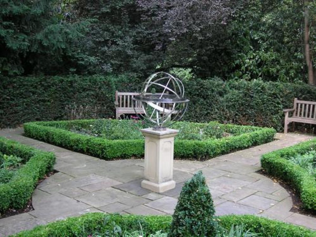
The garden of Wilton Crescent is laid out simply and is little altered from the design shown on the 1st edition OS map (1869). A paved path runs around the perimeter of the garden, which is bordered by a shrubbery with mature planes. A lawn occupies the centre of the garden, which has a centrally positioned stone urn.
REFERENCES
E B Chancellor, The History of the Squares of London (1907), pp 333, 335, 338-41
E Cecil, London Parks and Gardens (1907), p 239
Royal Commission Report on London Squares (1928)
London Squares Preservation Act (1931)
Hermione Hobhouse, Thomas Cubitt, Master Builder (1971)
B Cherry and N Pevsner, The Buildings of England: London 1 The Cities of London and Westminster (3rd edn 1973), pp 553-8, 635
London Historic Parks and Gardens Trust, London Squares (conference proceedings, June 1995)
Maps
J Rocque, Plan of the Cities of London and Westminster and Borough of Southwark and the country near ten miles around, surveyed 1741-5, published 1746
R Horwood, Map of London, 1792-9, 2nd edition 1813 by William Faden
Christopher and John Greenwood, Map of London, 1827
Thomas Cubitt, Plan of Pimlico, 1830, 1840, 1860
Bacon, Map of London, 1888
OS 25" to 1 mile:
1st edition published 1869
2nd edition published 1894
3rd edition published 1916
OS 60" to 1 mile:
1st edition published 1867
2nd edition published 1894
Description written: April 1998 Amended: December 2001, November 2002, April 2003
Register Inspector: LCH, CB
Edited: August 2003
- Visitor Access, Directions & Contacts
- History
The following is from the Register of Parks and Gardens of Special Historic Interest. For the most up-to-date Register entry, please visit the The National Heritage List for England (NHLE):
www.historicengland.org.uk/listing/the-list
HISTORIC DEVELOPMENT
The Grosvenor Estate lands in Belgravia and Pimlico, the Manor of Ebury, were acquired by the family in 1677 through marriage. The 300 acres (about 121 hectares) were fields, largely used by the 18th century for market gardening, except for a small strip off Grosvenor Place. No attempt had been made to build on it because most of the ground was marshy. A plan for part of the area, known since 1851 as Belgravia (derived from Belgrave, a village in Cheshire on Grosvenor land), was drawn up before 1813 by a Mr Wyatt (probably James Wyatt or Thomas Wyatt) but not executed. In 1820, Ebury Square (outside the area here registered) was laid out on the site of Ebury Farm but nothing further was done about Wyatt's plan until 1821 when Thomas Cundy was appointed surveyor of the Grosvenor Estate. Cundy adapted the Wyatt plan by adding Wilton Crescent to the planned Belgrave and Eaton Squares. Cundy's plan was ready in 1825 and building leases were sold to a number of contractors of whom Thomas Cubitt (1788-1855, who had already developed estates in North London and Bloomsbury) was the main developer. In 1825 Cubitt solved the problem of the marshy ground by taking earth excavated from St Katherine's Dock (another Cubitt project) and raising the height of the ground. The plan connected a series of irregular squares and crescents by means of a single spine road, on the main axis and a subsidiary axis.
Belgrave Square, Chester Square, Eaton Square, and Wilton Crescent stand on land which was known as Five Fields, and lay to the west of a single row of gentlemen's houses in what is now Grosvenor Place. The land is shown on Horwood's map of 1813 as open and overlooked by the backs of houses in the surrounding roads. The first square to be laid out was Belgrave Square, which takes its name from one of the estates held by the freeholder, the first Marquess of Westminster. It was started in 1825, largely built by George Basevi, and Wilton Crescent followed in 1827, built by Thomas Cubitt and W H Seth-Smith, another builder and contractor. Wilton Crescent derives its name from the first Earl of Wilton, father-in-law of the first Marquess of Westminster. In 1840 trustees were appointed to manage Belgrave Square and this arrangement continued until 1947 when a separate committee was formed to advise on the management of the garden. The gravel walks were laid in 1854, privet hedges were planted around the perimeter, and the site was enclosed in iron railings.
Eaton Square was also started in 1827 and derives its name from Eaton Hall in Cheshire, the seat of the Duke of Westminster. Greenwood's survey of that year shows the six rectangular gardens that form Eaton Square, with trees planted in lawns encircled by perimeter paths and shrubberies, and with multiple entrances. The central garden on the south-east side had a central bed with curvilinear lawns to the east and west, slightly constricted in the centre. The north-east garden on the south-east side had a central flower bed, and the garden to the south-west on the south-east side had three circular beds. John Allen, founder of the nearby Union Nursery (Sloane Square) was responsible for planting the gardens on the south side. The area of the north-east garden on the north-west side was used as a nursery garden by the firm of McKenzie by 1822. Despite the developments, McKenzie continued to conduct business there until 1842. By 1843, the houses to the north-west and south-west sides of Eaton Square had been completed by Cubitt and his map of 1843 includes the layout of the gardens, all with individualdesigns. It was not until 1853, by which time another builder, Seth-Smith had taken on the development, that the houses on the north-east side were built.
The 1st edition OS map of 1864 shows the completed buildings and gardens in Eaton Square, with the designs of the south-west and north-east gardens on the south-east side resembling those shown on Cubitt's plan, and the other gardens to slightly altered plans. The south-west garden on the south-east side was raised by 4ft (about 1.2 metres) in the 1860s and was subsequently replanted by James Veitch, nurseryman. The 2nd edition Ordnance Survey (OS) map of 1894 shows that, in addition to alterations to thoroughfares, the entrances to the gardens had been changed. The north-east garden on the south-east side retained two entrances, from King's Road and Eaton Square; access to the other gardens was from the Eaton Square side only.
The fourth square to be laid out was Chester Square, which was planned in 1828 but was not started until 1835. Thomas Cundy designed St Michael's church at the southern end of the square in 1844 and the houses were designed by Cubitt. Chester Square had been laid out as three gardens but by the late 19th century (OS 1894) the central and southern gardens had been joined together to form a single garden.
During the Second World War, the gardens in Belgrave Square were covered with clinker and used as an army vehicle compound, and the six gardens which make up Eaton Square were ploughed up, and the railings were removed. The gardens in all the squares were reinstated after the war.
The gardens of all the squares remain (2003) in private ownership.
- Associated People
- Features & Designations
Designations
The National Heritage List for England: Register of Parks and Gardens
- Reference: GD1785
- Grade: II
Features
- Shrubbery
- Folly
- Statue
- Town House (featured building)
- Earliest Date:
- Key Information
Type
Designed Urban Space
Purpose
Ornamental
Principal Building
Parks, Gardens And Urban Spaces
Survival
Extant
Hectares
2
- References
References
- {English Heritage Register of Parks and Gardens of Special Historic Interest} (Swindon: English Heritage 2008) [on CD-ROM] Historic England Register of Parks and Gardens of Special Historic Interest
- Cherry, B and Pevsner, N {The Buildings of England: London 1: the Cities of London and Westminster} (Harmondsworth: Penguin, 1973) pp 553-558, 635 The Buildings of England: London 1: the Cities of London and Westminster
- The Landscape Agency {Belgrave Square Gardens: Management Plan} (2002) Belgrave Square Gardens: Management Plan
- Related Documents
-
CLS 1/79/332
Management Plan - Hard copy
The Landscape Agency - 2003
-
CLS 1/79/332