Introduction
Attingham Park has a landscape park, deer park and woodland of around 200 hectares. The park encloses gardens around the hall. There is also a Home Farm run by National Trust tenants.
The following is from the Register of Parks and Gardens of Special Historic Interest. For the most up-to-date Register entry, please visit The National Heritage List for England (NHLE):
A landscape park improved by Thomas Leggett around 1770 and by Humphry Repton around 1798, the latter incorporating structures by John Nash, associated with a country house.
Location, Area, Boundaries, Landform and Setting
Attingham Park (c 270ha) lies immediately north-east of the village of Atcham, which itself lies on the east bank of the River Severn. The park is bounded to the south by the Watling Street (the B4380), and to the west by a minor road connecting Atcham with Berwick Wharf and Upton Magna. The other boundaries follow field and wood edges.
Entrances and Approaches
The main approach is along a drive which runs c 1km north-east across the park, the porticoed façade of the Hall only properly being revealed c 300m before it is reached. This approach was among Repton's Red Book suggestions of 1798, and its construction was apparently anticipated by work of c 1799 by John Nash who devised a scheme to improve the surrounds of the intended new entrance by adding gothick touches to several of Atcham's cottages and by knocking down a group on the north side of Watling Street. The drive enters the park at an entrance on the edge of Atcham village, at the east end of the bridge which carries the Watling Street across the River Severn. Here stands Atcham Lodge (listed grade II*), an ashlar triumphal arch with screen and lodges, of 1807 by John Nash.
Until the construction of this entrance the main approach off Watling Street was via a gate 1.5km to the east, adjoining which in the late C18 stood a small lodge or turnpike cottage. Soon after 1800 this was replaced by Tern Lodge (listed grade II), an octagonal, ashlar building, probably designed by John Adey Repton (d 1860). Repton's father, Humphry, intended this to be faced by an identical lodge, on the south side of Watling Street, to give the impression that the traveller was passing through the park rather than along its edge. This gate was not used in the late C20.
A rear approach is from the west. At its end is Back Lodge (listed grade II), a small, two-storey gothick lodge with battlemented, two-storey porch of the mid to late C18.
Principal Building
Attingham Hall (listed grade I), built for the first Lord Berwick in 1783-5 to a design by George Steuart (d 1806), is an imposing sandstone ashlar building, comprising a main, three-storey, U-plan block with curved colonnaded wings (from which there are views south across the park) leading to set-back flanking pavilions. Dominating the main, south front of the building is a tetrastyle Ionic portico with triangular pediment. Internal alterations were made in 1805-7 by John Nash. Behind (north of) the Hall is a walled service yard (listed grade II*), in the later C20 its interior used mainly as a car park. Tern Hall, Attingham's predecessor, stood on the site of the inner courtyard until demolished c 1840.
About 200m west of the Hall is a quadrangular, ashlar-faced stable block (listed grade II*) of c 1785 by George Steuart. Half hidden behind a low hill, the nine-bay south front with its end and central pavilions, the latter with a blocked carriage arch, forms a large eyecatcher as the Hall is approached from the south-west.
Gardens and Pleasure Grounds
A gravel sweep lies before the south portico; beyond a lawn extends c 50m to a 200m long, slightly curving, red-brick ha-ha (listed grade II), probably of c 1798 and part of Repton's improvements. The lawn extends around to the east and west of the Hall. From the east lawn, which has a stand of cedar, perhaps early C19, on its northern part, there are views across the River Tern at the bottom of the lawn to the deer park beyond. A 100m long gravel path runs east across the southern part of the same lawn, from the sweep in front of the Hall to a compact estate bridge (listed grade II*) across the Tern. Of grey, sandstone ashlar, the bridge is of 1780. It has been attributed both to William Hayward (d 1782) and to Robert Mylne (d 1811). The path continues east, over a small island and a C20 bridge over a weir, to a gate into the deer park.
About 70m south-east of the Hall is an icehouse (listed grade II), probably late C18.
In 1929, Brenda Colvin (d 1981) designed a wild garden for north of the Hall and a formal scheme including a knot garden extending east from the Hall down to the River Tern. Both were unexecuted.
As well as a kitchen garden and orchard Tern Hall had pleasure grounds; a lease of 1711 mentions the best flower garden and the Greenwalk leading from it to the river. Improvements were made in 1754-5 by John Burkenshaw (or Berkinshaw) (d 1774), a gardener brought in to improve the Hall's surrounds. Terracing was extended towards the river, a bowling green created and shrubberies planted. William Emes (d 1803) added a greenhouse in 1774.
Park
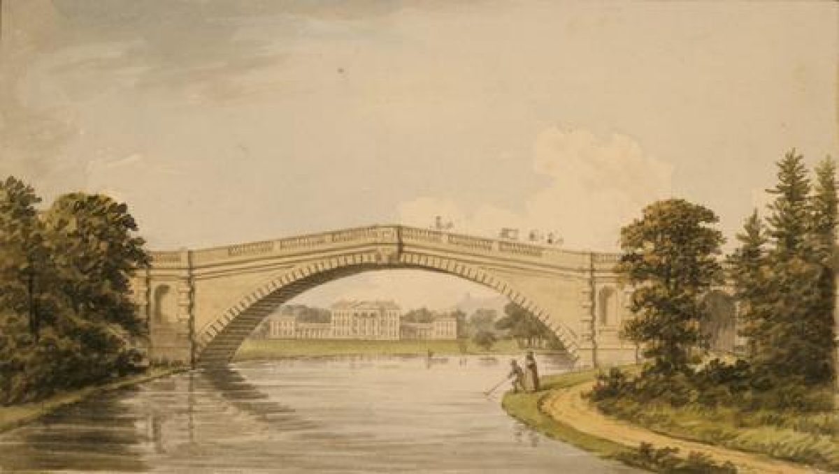
Attingham Hall lies on the west bank of the River Tern, close to the centre of its parkland. This is bisected from north to south by the river which separates the landscape park and the Hall to the west from the deer park to the east. About 1770 Thomas Leggett directed works to improve the view of the river from the old house, but Repton found the results unsatisfactory and broadened and smoothed the line of the Tern. On the southern edge of the park the river is carried under the Watling Street at Tern Bridge (listed grade II*), probably constructed in 1780 by William Hayward to a design by Robert Mylne. Of ashlar, with a single span and balustraded parapet, the bridge provides one of the best views of Attingham and, equally, is an eyecatcher when the park is viewed from the Hall. Among Repton's unexecuted Red Book suggestions was a proposal to make the bridge more monumental by adding an arch on the east side. West of the bridge the landscape park is bounded, in part, by a brick wall. It was presumably this which John Byng saw in 1793 when he noted that 'Lord Berwick ... does right to begin building a wall ... to keep out insolence and roguery' (Andrews 1936 iii, 232).
The landscape park is flat permanent pasture, underlain in parts by ridge and furrow, with large numbers of mature parkland trees, mostly in clumps. There are plantation belts along its south and west boundaries. There is denser planting, including of ornamental trees, linking the Hall, stables and kitchen gardens, and along the west bank of the Tern. This, essentially, is the course followed by the circuit known as the Mile Walk. From its 800m long riverbank section, northward of the Hall, there are extensive views east over the deer park. Along its length are some of the largest specimen trees at Attingham including sweet chestnut and cedar.
East of Back Lodge, on the west edge of the park, is the site of the village of Berwick Maviston, depopulated in the years after 1800 as the park was enlarged to the west. Remaining upstanding is what is now Home Farmhouse (listed grade II), a large, red-brick building ostensibly of C18 and C19 date, incorporating fabric of the C15 and C17. Some 200m north-east are the remains of a water-filled moat, the site of the manor house. Earthworks of the village south of this are confused by those of a Second World War camp. Running south from the village site, parallel with the brick wall of c 1800 which forms the west boundary of the park, are the 500m long earthworks of a branch arm of the Shrewsbury Canal, probably intended to serve a wharf at Atcham. Its construction was presumably abandoned when the park was extended.
The deer park east of the river is reached both by Mylne's bridge off the east lawn and by a suspension bridge 1km north of the Hall. The deer park, largely bounded to the south by cleft paling (of the 1970s and replacing a brick wall) and to the east by iron hurdles, is permanent pasture and contains large numbers of mature parkland trees. Its northern third is wooded; the Berwick Memorial stands towards the edge of the wood.
In 1710, Thomas Hill, to his later regret, entered into an agreement allowing the construction of an industrial complex on the River Tern hard by his new house. The noise of the mill had to be endured until 1755, and during that time the Hall remained in an agricultural landscape. In 1754 however, anticipating the end of industrial activity, gardener Burkenshaw was assessing the situation as 'better than he expected and that he never has seen any place where so great an Improvement was to be made at so small an Expence' (TSAS 66 (1989), 101). Burkenshaw planted some clumps but otherwise little, if anything, may have been done about laying out a park until 1769 when the Irish garden designer Thomas Leggett (fl 1780-1810) was brought in.
Between then and 1774 large sums were expended on planting thousands of trees - Burkenshaw acted as Leggett's foreman - including Scots pine, oak, elm, beech, flowering trees, shrubs and fruit trees, and on grading the slope down to the River Tern which was itself dredged and deepened. John Byng, the traveller, was unimpressed, in 1784 noting 'ugly grounds which are a flat with small circular plantations' and in 1793 'trees in clumps; water designed , and not finished' (Andrews 1936 i, 183; iii, 232).
Humphry Repton visited Attingham in April 1797 and produced a Red Book in 1798. He suggested enlarging the park along its western side by c 300m, and improving the view from the Hall by widening the Tern and removing the last remnants of Atcham forge, by planting trees in larger plantations and clumps and by opening gaps in Leggett's shelter belts to give glimpses of the world beyond. Proposals not taken up included making Tern Bridge more monumental and adding a spire to Wroxeter church, 5km to the south-east, as an eyecatcher.
Kitchen Garden
The walled kitchen gardens, built c 1793 to replace predecessors which lay adjacent to Tern Hall, lie 600m north-west of the Hall. They are hidden from it by woodland and shrubs and are reached via a wood-screened track which loops past the north side of the stables courtyard. The main brick-walled compartment (listed grade II) is rectangular, 120m long from east to west and 70m wide, and has rounded south-west and south-east corners. It is of c 1783-5. The interior is planted with Christmas trees (1998). A second, triangular, compartment (not listed), 30m wide, abuts the east end of the main garden. There are several greenhouses in the interior, while along the outside of the north wall are sheds. Brick bothies stand against its east wall.
North of the kitchen garden is an orchard, while to the south of it is a grass strip at the west end of which is a weatherboarded bee house (listed grade II), probably early C19.
Maps
[The following maps are all held in the Shropshire Records and Research Centre.]
- Map of Atcham and Attingham, 1793 (112/8/2)
- Map of Atcham and Attingham, nd (late C18), (112/8/1)
- Map of Atcham and Attingham, 1807 (3651)
- Map of Atcham and Attingham, 1813 (3651)
- R Baugh, Map of Shropshire, 1808
- OS 6" to 1 mile: 1st edition surveyed 1880-1, published 1890-1
- OS 25" to 1 mile:
- 1st edition surveyed 1881, published 1882
- 2nd edition surveyed 1900, published 1902
Archival items
- Humphry Repton, Red Book for Attingham (1798) [facsimile edition by The Balisk Press, London, 1977]
- Attingham Collection (Shropshire Records and Research Centre)
Description written: August 1998
Register Inspector: PAS
Edited: February 2000
- Visitor Access, Directions & Contacts
Telephone
441743708123Access contact details
Please note: The information on this website is advisory, but please always check the website of the house or garden you intend to visit before travelling.
Attingham is open daily from 8.00am, last entry is 6.00pm and the site closes at 6.30pm.
For detailed visitor opening times visit the National Trust website.
Directions
On B4380, 4 miles south-east of Shrewsbury, follow brown directional signage to the main gates and on to one way access drive through front parkland. Please note there may be cattle grazing in the parkland and the site is closed at 6.30pm.
- History
The following is from the Register of Parks and Gardens of Special Historic Interest. For the most up-to-date Register entry, please visit The National Heritage List for England (NHLE):
18th Century
The manor of Attingham or Atcham was purchased in 1700 by Richard Hill (died 1727), Deputy Paymaster on William III's Flemish campaigns. He immediately contracted to build a new house on the west bank of the River Tern, Tern Hall (or House). A bachelor, he left a reversion on the property to his nephew Thomas, who took the name Hill.
In 1768, Thomas settled the property on his son Noel, who almost immediately brought in Thomas Leggett to improve the park. It was only after his father's death in 1782 however that Noel (created Baron Berwick 1784, died 1789) was able to begin more ambitious improvements. Tern Hall was replaced with a grand new house which he called Attingham, for which enlarged kitchen gardens were provided. A decade later, in 1794, his son and heir Thomas Noel Hill, second Baron Berwick (died 1832) returned home from a European tour.
In 1797, he brought in Humphry Repton (died 1818) to improve the park, for which Repton's then partner John Nash (died 1835) supplied some of the architectural details.
19th Century
Nash returned to Attingham in 1805 to make alterations and additions to the house, the latter including a picture gallery to house paintings acquired on the European tour. Berwick had, however, over-extended himself and in 1827 a sixteen-day sale saw the disposal of most of the house's contents.
20th Century
Attingham nevertheless remained in the family until 1947 when the eighth Lord Berwick bequeathed the estate to the National Trust. The Trust remained the owner in 1998.
Period
- 18th Century (1701 to 1800)
- Late 18th Century (1767 to 1800)
- Associated People
- Features & Designations
Designations
The National Heritage List for England: Register of Parks and Gardens
- Reference: GD2117
- Grade: II*
Features
- Great House (featured building)
- Description: George Steuart designed the hall for the 1st Lord Berwick in 1785. There is also a picture gallery by John Nash.
- Earliest Date:
- Latest Date:
- Key Information
Type
Park
Purpose
Ornamental
Principal Building
Domestic / Residential
Period
18th Century (1701 to 1800)
Survival
Extant
Hectares
264
Open to the public
Yes
Civil Parish
Atcham
- References
References
- {English Heritage Register of Parks and Gardens of Special Historic Interest}, (Swindon: English Heritage, 2008) [on CD-ROM] Historic England Register of Parks and Gardens of Special Historic Interest
- Stamper, P. A., {Historic Parks and Gardens of Shropshire} (Shrewsbury: Shropshire Books, 1996), pp. 57-60, 62, 64-5, 84, 102, 106 Historic Parks and Gardens of Shropshire
- Chris Burnett Associates {Attingham Park: Historic Survey and Restoration Plan} (2000) Attingham Park: Historic Survey and Restoration Plan
- 49 (5 February 1921), pp 158-66; (12 February 1921), pp 186-93 Country Life
- Andrews, C. B. (ed), (1936) i, p 183; iii, pp 232-3 The Torrington Diaries
- Ionides, J., (1999), pp 207-18 Thomas Farnolls Pritchard of Shrewsbury
- 2 (1998), pp 8-14 Shropshire Parks & Gardens Trust Newsletter
- 65 (1987), pp 64-9; 66 (1989), pp 97-105 Transactions of the Shropshire Archaeological Society
- Attingham Park: Historic Survey and Restoration Plan
- National Trust (1979) Attingham Park, Guidebook