Introduction
Early and mid 19th century pleasure grounds and gardens surrounding an early 19th century mansion, set in a late 18th and early 19th century parkland landscape with surviving early and mid 19th century elements.
Arlington Court is an 18th century landscape park, woodland and agricultural estate of around 1400 hectares. The house is set within about 20 hectares of formal gardens and pleasure grounds, with a further 125 hectares of parkland, a lake, plantations and woodlands.
Terrain
The house, pleasure grounds and gardens occupy high ground to the north-east of the River Yeo, with parkland running down the south-west-facing slope, and with woodland opposite.The following is from the Register of Parks and Gardens of Special Historic Interest. For the most up-to-date Register entry, please visit The National Heritage List for England (NHLE):
Location, Area, Boundaries, Landform and Setting
Arlington Court is situated c 8km north-north-east of Barnstaple and c 5km south-south-east of the coastal village of Combe Martin, on the east side of the A39 which runs north-east from Barnstaple to Lynton. The c 145ha site comprises some 20ha of formal gardens and pleasure grounds, and c 125ha of parkland, lake, plantations, and woodland. The house, pleasure grounds and gardens occupy high ground to the north-east of the River Yeo, with parkland running down the south-west-facing slope, and with woodland opposite.
The site is partly bounded to the north-west by the A39, and to the north and north-east by a minor lane leading to Arlington village. The parish church and churchyard adjoin the site c 200m east-south-east of the house. Elsewhere the site is enclosed by traditional hedge banks and farm fences which allow the parkland and woodland to merge with the surrounding wooded agricultural landscape. Deerpark Wood c 1km south of the house is significant in framing views from the site up the Yeo valley.
Entrances and Approaches
The site is approached from a minor lane which leads from the A39 to the village of Arlington, and which forms the north-east and north boundary of the site. Some 80m south-south-east of the gabled mid C19 Home Farm, convex drystone-faced banks c 1.5m high flank stone gate piers originally surmounted by ball finials and cast-iron herons (missing 1998) which support latticed painted timber gates (listed grade II). The gravelled drive runs c 240m south-south-east between grass verges with mature oaks and other deciduous trees underplanted with rhododendrons and evergreen shrubs to create the effect of woodland glades.
Passing the site of a lodge marked on the Tithe map (1844) and the 1904 OS map, the drive turns and runs a further 250m east and south to reach a carriage circle to the north of the house. The central lawn is planted with trees and shrubs, and a service drive leads south-west to the service court, while the main drive continues to the east front of the house where there is a further gravelled forecourt. An approach from Woolley Lodge c 1.5km south-west of the house was completed before 1809, with a farm track carried under the drive through a tunnel. The neo-classical single-storey lodge and gate piers supporting cast-iron herons (all listed grade II) survive, together with the mid C19 supports for a projected suspension bridge to carry the drive over the lake c 800m south-west of the house. The Tithe map (1844) shows that a network of carriage drives through the pleasure grounds and park was already established by that date.
Principal Building
Arlington Court (listed grade II*) stands on high level ground c 200m west-north-west of the parish church and enjoys wide views within and beyond the site to the east, south and west. Built in 1820 by Thomas Lee of Barnstaple for Colonel John Chichester, the main range is a neo-classical villa showing the influence of Soane (listed building description). The two-storey ashlar building has basement service rooms concealed by a stone-flagged terrace on the east and south facades, while on the west a late C20 cast-iron pergola has been constructed at basement level.
The entrance façade to the east has a Greek Doric porch supported by fluted columns and approached from the carriage court by stone-flagged steps. A wing was built to the north-east of the original house c 1864-5 and has distinctive rusticated arched windows under a pitched slate roof. A corresponding wing to the north-west contained a new dining room, subsequently used by Miss Chichester as a museum. Infested with dry rot, this was demolished in 1949.
Gardens and Pleasure Grounds
The formal and informal gardens and pleasure grounds lie to the east, south and west of the house. Stone steps lead from the flagged terrace below the south façade of the house to the pleasure grounds which are separated from the park to the south and west by a late C20 ha-ha which replaced C19 metal estate fencing. Groups of trees and ornamental shrubs to the south-east, south-west and north-west of the house frame vistas across the park and surrounding agricultural landscape, and a circuit of gravel and mown grass walks passes through the shrubberies. Within the shrubbery c 100m south-west of the house a stone pedestal on a rusticated base supports a marble carving of a sleeping puppy which commemorates Sir Bruce Chichester's dog Memory (d 1868); beyond this is the C19 pheasantry, restored c 1990.
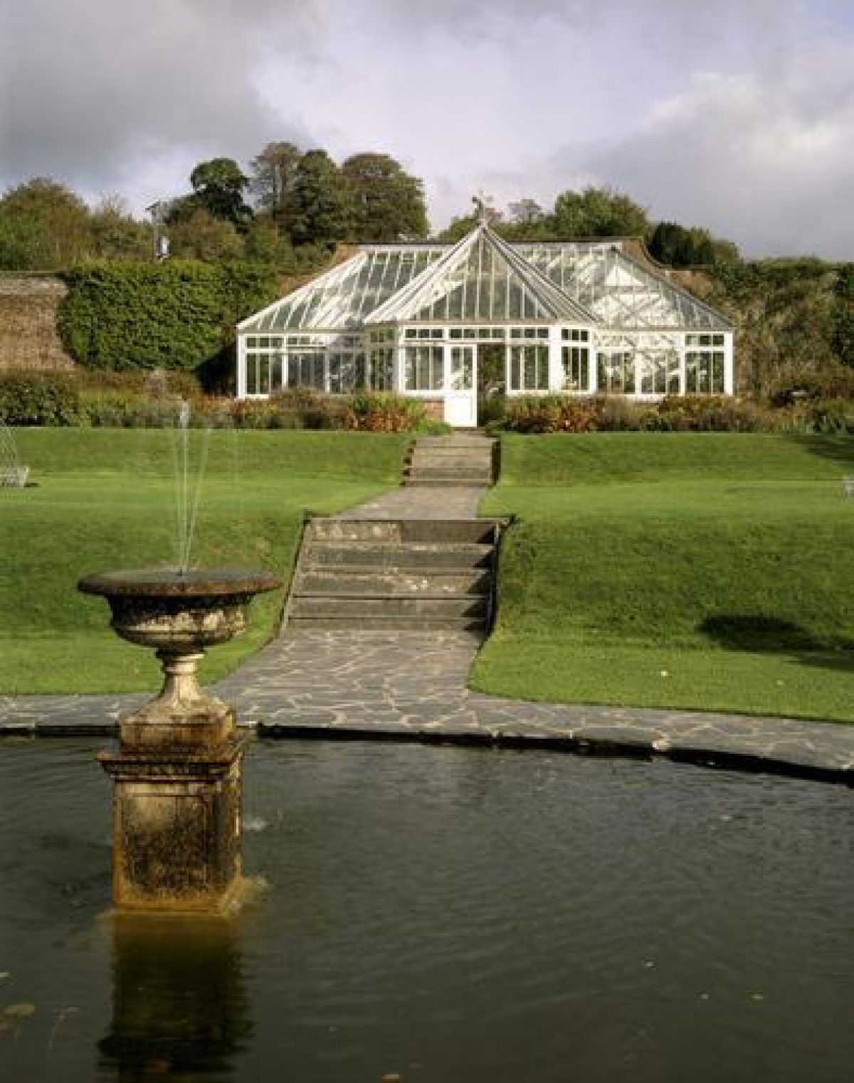
Some 130m north-east of the house the mid C19 formal flower garden is separated from the pleasure grounds by a low metal fence to the south-west, by hedges to the north-west and south-east, and by a brick wall to the north-east which forms the boundary of the kitchen garden. The flower garden is laid out with four terraces descending from a timber and glass conservatory, rebuilt against the north-east wall in the late C20 to the mid C19 plan. The terraces are linked by centrally placed steps flanked by stone urns and cast-iron herons, and by a gravel walk which adjoins perimeter beds which are edged with white quartz.
The lower terrace has a rocky retaining wall planted with azaleas, above which the second terrace has a central circular pool surrounded by white quartz and a narrow flower bed. The pool contains a fountain which rises from an urn on a pedestal, while wire lattice arches enclose it to the north and south. The third terrace comprises a wide lawn with two symmetrically placed wire-lattice-edged circular flower beds, and two late C20 monkey puzzles which replace C19 specimens.
The upper terrace has a transverse gravel walk which adjoins the low brick plinths for the north-west and south-east wings of the C19 conservatory, which are now ornamentally planted. The walk is terminated at each end by a wisteria arch placed in front of a metal seat. The conservatory has a half-octagonal bay placed on the central axis of the garden, and its roof is ornamented with a further cast-iron heron. Planted with tender climbers and shrubs, a door in the rear wall connects with the kitchen garden. To the south-east the Flower Garden is adjoined by the grounds of Glebe House (listed grade II*), the early C19 former rectory. Lying within the registered site, these have a gravelled carriage circle to the south of the house, and early and mid C19 pleasure grounds with evergreen shrubbery planting and lawns to the west and north-west.
Some 370m east-south-east of Arlington Court, and beyond the parish church and mid C19 stables and coachman's house (listed grade II), the late C19 stone and brick Kennel Cottages adjacent to the site of the C19 kennels form the eastern extremity of the pleasure grounds. Some 200m south-east of the house, and concealed from it by late C19 rhododendrons, shrubbery and conifers, the Wilderness Pond (restored 1970s) lies at the head of The Wilderness, a wooded valley and stream which extends c 500m south-south-west into the park from the main area of pleasure grounds around the house.
Replacing an area of late C18 orchards (Hassall, 1776) and possibly medieval fishponds, The Wilderness is separated from the parkland to the west by a low stone wall and bank, and is shown as woodland on the Tithe map (1844). A carriage drive on the west side of The Wilderness connects the pleasure grounds to the circuit of drives in the park.
Park
Lying principally to the south and west of the house, the parkland occupies the west- and north-west-facing slopes of the Yeo valley and is characterised by pasture with scattered ornamental trees, mainly beech and sycamore, and by perimeter belts, originally planted in the early and mid C19. To the south and south-west of the house some trees are planted on mounds retained by circular drystone walls which act as cattle guards.
In the valley bottom the River Yeo is dammed to form a serpentine lake c 650m south-west of the house. Created for Sir John Chichester in 1837, the lake was extended to its present size in 1851 when the two surviving stone pylon supports for the projected bridge designed by William Dredge of Bath were built on the site of the original dam. Severely silted by the 1930s, it remains significantly silted despite dredging in 1980 (guidebook).
The carriage drive runs along the north-east bank of the lake, passing an C18 stone urn and pedestal by Robert Adam c 670m south-west of the house erected in 1949 to commemorate Miss Chichester. The drive passes north through Brockham Plantation, established c 1842, and is flanked by monkey puzzles originally planted in the 1860s and extensively replanted in the late C20. Turning north-east, the carriage drive joins the principal drive adjacent to the entrance gates c 400m north-west of the house. East Park, the focus of the late C18 landscape at Arlington, lies c 400m south-east of the present house and to the south of the site of the C16 and late C18 house south of the parish church. Bounded to the west by The Wilderness, East Park remains pasture with a circular, tapering, random white quartz cairn or rustic obelisk (listed grade II) c 400m south-east of the house commemorating Queen Victoria's Golden Jubilee (1887). Some 300m north of the house Town Meadow was developed as a paddock in the early C19 and adjoins the late C20 visitors' entrance to the site.
Kitchen Garden
Immediately north-east of the Flower Garden, the kitchen garden was established in its present form by 1844 (Tithe map). Enclosed by tile- and slate-coped random stone walls c 3m high to the south-west, north-west and south-east, and by a brick-faced stone wall to the north-east, the kitchen garden retains cruciform sand paths, together with a circular central dipping pool surrounded by white quartz stones. Largely laid to grass, there are young wall-trained fruit trees on the south-east wall, together with a rebuilt brick and timber glasshouse in the north corner. Timber doors survive in the south-west and north-east wall, the latter leading to the 'outer garden and pinery' in 1844 (Tithe map). The outer garden is now (1998) a meadow, while c 30m north of the kitchen garden the remains of the pinery designed in 1814 survive under shrubbery.
Other Land
Woolley Wood c 1km south-west of the house on the north-east-facing slopes of the Yeo valley appears to have existed by the early C16, and remains a plantation principally of oak. A spur of woodland, Woolley Belt, extends c 800m west and south-west from Woolley Wood to the early C19 Woolley Lodge on the Barnstaple road which was built for the early C19 south-west drive. Deerpark Wood c 1km south-east of the house and south of Sir John Chichester's late C18 park may have been the site of a C16 deer park (Colvin and Moggridge 1994), and was developed in the mid C19 by Sir Bruce Chichester with an extended series of walks and carriage drives. The drives extend south through Webber's Wood, which is also included in the registered site.
Maps
- B Donn, A Map of the County of Devon, 1765
- C Hassall, Survey of Arlington Court, 1776 (private collection), [in Colvin and Moggridge 1993]
- A Map of North Wooly, late C18 (North Devon Record Office) Plan of proposed penstock near the old stables at Arlington, 1792 (50/11/161), (North Devon Record Office)
- W Mudge, Map of Devon, 1" to 1 mile, 1809
- W A Hay (?), Plans and Elevations of Pine Pits at Arlington Court, 1814 (50/11/145-50), (North Devon Record Office)
- T Lock, Tithe map for Arlington parish, 3 chains to 1", 1844 (Devon Record Office)
- R Turner, Sketch of Proposed Conservatory for Sir Bruce Chichester Bart, 1849 (50/11/152), (North Devon Record Office)
- J W Thomson, Elevation of proposed conservatory, nd (50/11/151), (North Devon Record Office)
- W Walker, Plan and elevation of proposed circular conservatory, nd (50/11/153), (North Devon Record Office)
- Elevation of square conservatory, nd (50/11/154), (North Devon Record Office)
- OS 6" to 1 mile:
- 1st edition surveyed 1888
- 2nd edition revised 1903, published 1905
- OS 25" to 1 mile:
- 1st edition surveyed 1888, published 1889
- 2nd edition revised 1903, published 1904
Illustrations
- Maria Pixell, four views of Arlington Court, 1797 (at Arlington Court 1998)
Archival items
- The Chichester family papers including household and stewards' accounts are held at the North Devon Record Office (B170add/35, B170add/234 and B170add/50/11).
Description written: October 1998 Amended: June 1999
Register Inspector: JML
Edited: July 2000, March 2022
- Visitor Access, Directions & Contacts
Telephone
441271850296Access contact details
The house and gardens are open from March to December.
For more information visit the National Trust website.
Directions
The property lies 8 miles north of Barnstaple on the A39.
For more detailed directions visit the National Trust website.
Owners
The National Trust
Heelis, Kemble Drive, Swindon, SN2 2NA
- History
The following is from the Register of Parks and Gardens of Special Historic Interest. For the most up-to-date Register entry, please visit The National Heritage List for England (NHLE):
11th - 16th Century
The manor of Arlington, which is mentioned in Domesday Book (1086), was acquired by John Chichester in 1384 when he married the heiress of John Ralegh. The Chichesters did not take up residence at Arlington until 1534, when Amyas Chichester rebuilt an existing manor house which stood south-east of the parish church, some 200 metres south-east of the present house.
16th - 17th Century
Despite heavy fines for recusancy, the family increased its wealth in the 16th and 17th centuries through a series of marriages with heiresses, which also brought estates inn Wales. Woolley Wood south-west of the house and park is known to have existed by the early 16th century and is probably the earliest surviving feature of the Arlington landscape (guidebook). Deerpark Wood about 1 kilometre south-south-east of the present house and outside the registered site may indicate the existence of a deer park associated with the 16th century house. Open fields were gradually enclosed from about 1630 to form a mixed agricultural landscape from which the ornamental landscape evolved in the late 18th century.
18th Century
A survey by Charles Hassall (1776) shows enclosed gardens south of the house, two areas of woodland north-east and south-east of the house known as Grove Woods which may have been ornamental, and orchards on the site of the present Wilderness.
Colonel John Chichester (1769-1823) rebuilt the 16th century manor house on the same site in about 1790, employing the London architect John Meadows to produce designs. Lacking proper supervision during its construction, this house had to be demolished in about 1820.
Late 18th century paintings by Maria Pixell, now hung in the house, show Colonel Chichester's house to have been a conventional white-painted three-storey villa with a full-height bow window on the south façade overlooking the wooded valley known as The Wilderness, and canted bays to the east and west. Pixell's suggestion of parkland south and south-west of the 1790 house is confirmed by William Mudge's county map of 1809. This also indicates that the south-west approach from Woolley Lodge was established, and Deerpark Wood planted before 1809.
19th Century
In about 1820 Colonel Chichester built the present house on a new site about 200 metres west of the Church from designs commissioned from the Barnstaple architect Thomas Lee. It is likely that Colonel Chichester was responsible for the layout of the pleasure grounds around the new house, but it was his son, John Palmer Bruce Chichester (1794-1851) who carried out much of the parkland planting and first created the lake to the south of the house. The landscape recorded on the 1844 Tithe map corresponds closely to what survives today with the flower garden, pinery, kitchen garden, Wilderness and areas of park east, south, south-west and west of the house all established.
Nurseries about 300 metres north of the church (now outside the site) were established to produce trees for the park (Gardener's Magazine 1838). Sir John's son, Sir Bruce, was a minor when he inherited in 1851. The last of the male line, Sir Bruce added a new service wing and dining room to the house and adapted it for fashionable entertaining. He was also responsible for the introduction of features such as the Monkey Puzzle Avenue, embellishing the early and mid 19th century landscape. Spending lavishly on yacht racing, at his death in 1881 he left debts which took fifty years to pay off.
20th Century
Miss Rosalie Chichester assumed control of the Arlington estate, where she lived until her death in 1949. An avid collector, Miss Chichester amassed a diverse collection of artefacts at Arlington, which, together with the house and estate, she bequeathed to the National Trust. The grounds were first opened to the public by Miss Chichester, who had been impressed by National Parks in Australia and New Zealand in the 1920s. The National Trust undertook essential management including a programme of woodland regeneration, and further renovation of the formal garden and pleasure grounds was undertaken during the 1970s and early 1980s.
The site is now in the care of the National Trust.
Period
- 18th Century (1701 to 1800)
- Late 18th Century (1767 to 1800)
- Associated People
- Features & Designations
Designations
The National Heritage List for England: Register of Parks and Gardens
- Reference: GD1678
- Grade: II*
Style
English Landscape Garden
Features
- Stable Block
- Kitchen Garden
- Description: Walled kitchen garden, recently restored.
- House (featured building)
- Description: A gabled mid C19 Home Farm
- Earliest Date:
- Latest Date:
- Lake
- Formal garden, Pleasure ground
- Description: 0ha of formal gardens and pleasure grounds,
- Woodland, Parkland
- Description: 125 hectares of parkland, a lake, plantations and woodlands.
- Mansion
- Description: Early 19th century mansion,
- Church
- Description: The parish church and churchyard adjoin the site c 200m east-south-east
- Woodland, Parkland
- Description: Traditional hedge banks and farm fences which allow the parkland and woodland to merge with the surrounding wooded agricultural landscape. Deerpark Wood
- Gate Piers
- Description: A high flank stone gate piers originally surmounted by ball finials and cast-iron herons.
- Gates
- Description: Latticed painted timber gates
- Shrubbery, Trees
- Description: Grass verges with mature oaks and other deciduous trees underplanted with rhododendrons and evergreen shrubs to create the effect of woodland glades.
- Drive, Bridge
- Description: Mid C19 supports for a projected suspension bridge to carry the drive over the lake
- Lawn, Flower Bed, Monkey puzzles
- Description: The third terrace comprises a wide lawn with two symmetrically placed wire-lattice-edged circular flower beds, and two late C20 monkey puzzles which replace C19 specimens.
- Church
- Garden Terrace, Conservatory, Flower gardens
- Description: The flower garden is laid out with four terraces descending from a timber and glass conservatory
- Serpentine lake
- Description: In the valley bottom the River Yeo is dammed to form a serpentine lake
- Dipping Pool
- Description: A circular central dipping pool surrounded by white quartz stones.
- Memorial
- Description: A rusticated base supports a marble carving of a sleeping puppy which commemorates Sir Bruce Chichester's dog
- Drive, Gates
- Description: The carriage drive joins the principal drive adjacent to the entrance gates
- Kitchen Garden
- Key Information
Type
Estate
Purpose
Ornamental
Principal Building
Domestic / Residential
Period
18th Century (1701 to 1800)
Survival
Extant
Hectares
1400
Open to the public
Yes
Civil Parish
Arlington
- References
References
- {English Heritage Register of Parks and Gardens of Special Historic Interest} (Swindon: English Heritage 2008) [on CD-ROM] Historic England Register of Parks and Gardens of Special Historic Interest
- Pevsner, N {The Buildings of England: Devon} (Harmondsworth: Penguin, 1952) The Buildings of England: Devon
- Colvin and Moggridge {The Historic Landscape of Arlington Court - Survey and Management Plan} (1993) The Historic Landscape of Arlington Court - Survey and Management Plan
- Lovie, Jonathan {Arlington Court: Conservation Statement} (2009) Arlington Court: Conservation Statement
- Vol 14, (1838), pp 505-10 The Gardener's Magazine
- (National Trust 1996) Arlington Court, guidebook
- Vol 169 (30 April 1981), pp 1178-81 Country Life